
Minnesota’s mix of big-city energy, small towns, and vast wilderness means getting around is part of the adventure. Whether you are cruising the interstate between Minneapolis and Duluth, flying into a regional airport in the north woods, or catching a bus across prairie country, understanding how transportation works in the state will help you make the most of your trip. This guide walks through the key driving routes, airports, and regional travel options so you can move confidently from the Twin Cities to the Canadian border and everywhere in between.
Understanding Minnesota’s Geography and Travel Distances
Planning travel in Minnesota starts with understanding its scale. The state stretches roughly 400 miles from north to south and about the same distance from east to west. Minneapolis and Saint Paul sit near the southeastern quadrant, while destinations like Duluth on Lake Superior, Rochester in the southeast, Moorhead on the North Dakota border, and Bemidji in the north are spread widely across the map. Even though many drives are straightforward, the distances can be longer than visitors expect, especially when traveling into lake country or the Boundary Waters region.
Within the Twin Cities, Minneapolis and Saint Paul are less than 10 miles apart, so it is easy to treat them as a single metro area. But heading farther afield quickly adds mileage. Driving between Rochester and Duluth, for example, covers roughly 190 miles, while Minneapolis to Moorhead is more than 200 miles by road. These are manageable half-day drives, but they are long enough that you will want to factor in rest stops, weather, and daylight hours, especially in winter.
Most long-distance road travel in Minnesota is oriented toward the Twin Cities. Major routes radiate outward from Minneapolis and Saint Paul toward regional centers such as St Cloud, Brainerd, Mankato, and Fargo–Moorhead. Because the road network is well developed, you can often choose between faster interstate highways and more scenic state and county roads that pass through farm towns, river valleys, and lake districts.
Travelers should also consider seasonal changes. In summer, long daylight and generally clear roads make it easy to cover a lot of ground in one day. In late fall, winter, and early spring, snow, ice, and shorter days can slow every leg of your itinerary. Building extra time into your travel schedule is a wise move, particularly if you are connecting to flights or events.
Key Driving Routes and Scenic Road Trips
For many visitors, driving is the most flexible and rewarding way to see Minnesota. Two interstate corridors form the backbone of the state’s highway system. Interstate 35 runs north–south, linking the Twin Cities to Duluth and, farther south, to Iowa. Interstate 94 is the primary east–west route, connecting Minneapolis and Saint Paul with St Cloud, Alexandria, and the Fargo–Moorhead area before continuing into North Dakota. These interstates are designed for efficient travel and are usually the fastest way to move between major cities.
Alongside the interstates, U.S. and state highways tie together key regions. U.S. Highway 52, for example, runs south from the Twin Cities to Rochester and then on toward the Iowa border, serving as a main artery for travelers headed to Rochester’s medical facilities or to the bluff country near the Mississippi River. State and U.S. highways also thread across central and northern Minnesota, linking lake resorts, small towns, and state parks. While these roads may have lower speed limits and occasional two-lane stretches, they often deliver the most memorable views.
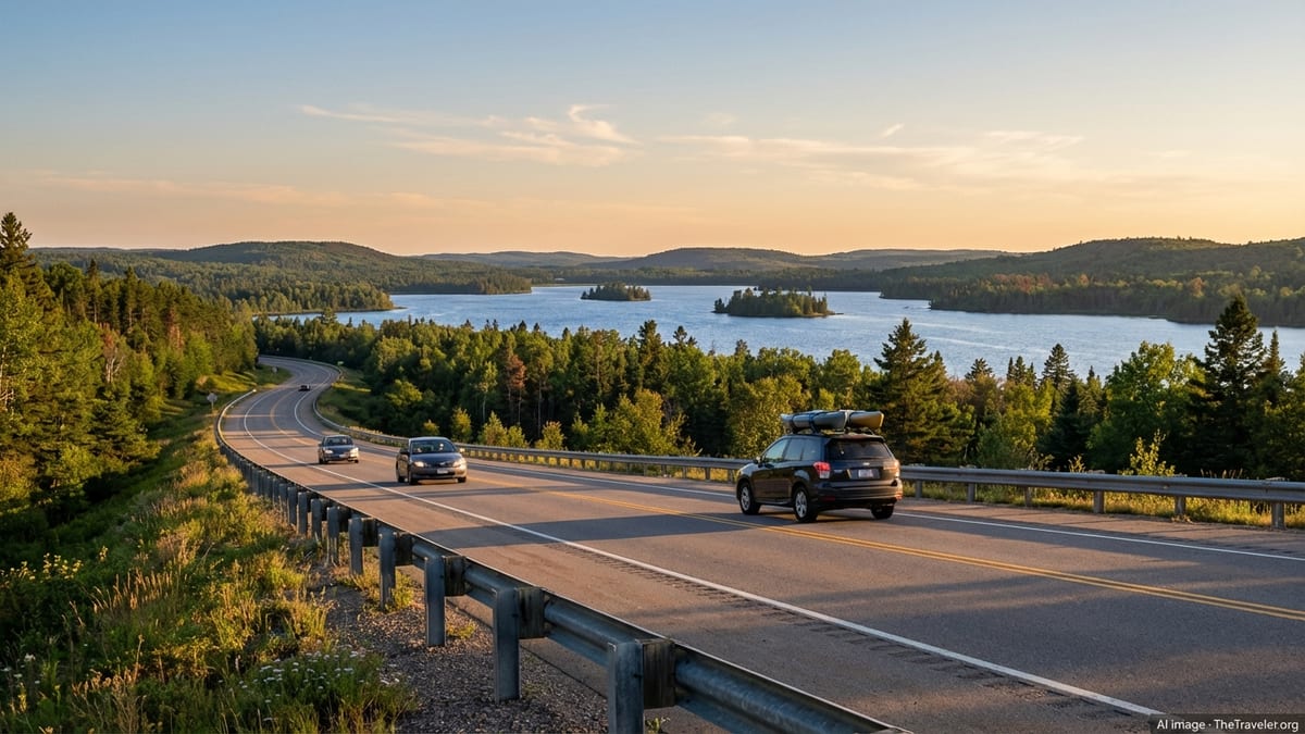
Some of Minnesota’s most iconic drives are deliberately scenic. The North Shore route from Duluth to Grand Marais and beyond hugs the Lake Superior shoreline, passing waterfalls, rocky cliffs, and state parks. In the southeast, the Great River Road follows the Mississippi River through historic river towns and limestone bluffs. Central Minnesota offers winding routes through the Brainerd Lakes and Alexandria areas, where tree-lined highways reveal glimpses of water around nearly every bend. These drives reward a slower pace, especially during autumn when fall colors peak.
When planning a road trip, consider balancing efficiency with scenery. You might take Interstate 35 straight to Duluth, then slow down along the North Shore. Or use Interstate 94 to reach central Minnesota quickly, then wander on smaller highways to explore lakes, trails, and small communities. Rest areas, waysides, and local diners dot the major routes, making it easy to pause, stretch, and experience local flavor along the way.
Driving Seasons, Winter Safety, and Road Conditions
Weather has a major influence on how you get around Minnesota, particularly if you are driving in late fall, winter, or early spring. Snow, ice, and occasional blizzards are a fact of life, and even locals adjust their habits when conditions turn. State and local road crews are experienced at plowing and treating highways, but it can still take time to restore normal travel conditions after a storm, especially in rural or northern areas.
Before you set out, it is important to check current road conditions and forecasts. The Minnesota Department of Transportation maintains statewide information on pavement conditions and visibility, using categories such as normal, partially covered, and completely covered to describe how much snow, ice, or slush is on the road. In severe situations, you may see advisories that travel is not advised or that certain highways are temporarily closed to most vehicles. Paying attention to these warnings and adjusting your plans can significantly improve safety and reduce stress.
If you do drive in winter, allow more time, slow down, and increase your following distance. Keep your gas tank at least half full and carry basic supplies such as warm clothing, a blanket, snacks, and a phone charger. Visibility can change quickly when wind-driven snow creates whiteout conditions, especially on open stretches of highway. On those days, it may be more comfortable to delay travel, focus locally, or use transit in urban areas instead of undertaking a long highway drive.
In contrast, summer and early fall offer some of the best driving conditions of the year. Road construction is more common in warmer months, so you may encounter lane closures or detours on interstates and state highways. These projects are usually well marked, and information is widely publicized. Building a small cushion into your schedule allows for construction delays, photo stops, and spontaneous detours down side roads that look inviting.
Major Airports and Flying Within Minnesota
Air travel plays a central role in how people enter and move around Minnesota. Minneapolis–Saint Paul International Airport is the primary gateway, handling the vast majority of domestic and international flights to the state. Located between the two downtowns, it offers a large selection of nonstop routes across the United States and to select overseas destinations. For many visitors, flying into this hub and then continuing by car, bus, or regional flight is the most efficient way to reach other parts of Minnesota.
Beyond the main hub, a network of regional airports connects outstate communities with the Twin Cities and other cities. Destinations such as Duluth, Rochester, Bemidji, Brainerd, International Falls, Hibbing, Thief River Falls, and St Cloud all maintain airports with scheduled commercial service that typically links back to Minneapolis–Saint Paul. These flights are particularly useful if you are heading directly to the North Shore, the Iron Range, the north woods, or Rochester’s medical centers and prefer to minimize highway driving.
Regional airports tend to be smaller and easier to navigate than large hubs. Parking is usually close to the terminal, security waits are often shorter, and check-in can be swift. However, flight schedules may be limited, with fewer daily departures and arrivals, so it pays to book early and plan connections carefully. Weather, especially winter storms, can also affect regional flights. Building in time buffers between flights and ground travel is wise, particularly if you have a time-sensitive appointment or event.
Many travelers blend air and road travel to see more of Minnesota. For example, you might fly into Duluth to explore the North Shore, then drive south to the Twin Cities before departing through Minneapolis–Saint Paul International Airport. Or you could arrive in Rochester and make a loop through bluff country and small river towns before returning by car to the metro area. Using regional airports in combination with the highway network can significantly shorten travel times while still giving you plenty of flexibility.
Public Transit, Light Rail, and Urban Mobility in the Twin Cities
The Twin Cities region offers the most robust public transportation in Minnesota, making it possible to explore much of Minneapolis and Saint Paul without a car. Metro Transit operates local buses, light rail lines, and bus rapid transit routes that connect downtowns, major neighborhoods, universities, and key employment centers. For visitors, these services are particularly useful for reaching cultural districts, stadiums, and airport hotels while avoiding downtown parking costs.
The light rail system links Minneapolis–Saint Paul International Airport with both downtowns and the University of Minnesota. One line runs between downtown Minneapolis and the Mall of America, passing directly through the airport terminals, while another line connects downtown Saint Paul with downtown Minneapolis. Together, they form a spine of frequent, all-day service that is convenient for travelers staying near the rail corridor. Trains run regularly throughout the day, with reduced but still practical service in early morning and late evening hours.
Bus rapid transit and limited-stop bus routes complement the rail network. These lines typically run more frequently and make fewer stops than standard bus routes, using features such as dedicated lanes, off-board fare payment, and signal priority to improve travel times. In recent years, the Twin Cities have expanded bus rapid transit corridors to connect major streets and business districts, offering a faster alternative to local buses on busy routes. For visitors, these services can provide a reliable way to travel longer distances in the metro without renting a car.
Outside the core of Minneapolis and Saint Paul, suburban and regional providers operate additional bus routes. Agencies such as the Minnesota Valley Transit Authority and others link park-and-ride lots, shopping centers, and residential areas to the downtowns and key transit hubs. If you are staying in the suburbs, using these services in combination with light rail or bus rapid transit can be an efficient way to reach events, museums, and airports while leaving your car at your hotel or a park-and-ride facility.
Regional Buses, Trains, and Travel Beyond the Metro
While most of Minnesota is best explored by car, travelers without access to a vehicle still have options for reaching many regional centers. Several intercity bus operators connect the Twin Cities with communities across the state and into neighboring regions. Buses often depart from central hubs in Minneapolis and Saint Paul, including major terminals served by multiple carriers. From there, routes fan out along interstate and highway corridors to cities such as Duluth, Rochester, St Cloud, Mankato, Bemidji, and beyond.
Intercity buses are generally comfortable, with reserved seating, climate control, and onboard restrooms. They are a good choice for travelers who prefer not to drive, are watching their budgets, or want to work or rest en route. Because schedules can be limited, especially on weekends or in smaller communities, advance planning is essential. Checking departure and arrival times a few days before travel allows you to coordinate local transit or rideshare options on either end of your journey.
Rail options complement bus service on some corridors. The Northstar commuter rail line connects downtown Minneapolis with several communities to the northwest, ending in Big Lake, where connecting bus services continue toward St Cloud. This can be a convenient combination for travelers who want to avoid driving in the core metro area but still reach central Minnesota. Passenger trains on national routes also serve the Twin Cities and a selection of Minnesota towns, providing another alternative for regional and cross-country travel.
In Greater Minnesota, local public transit systems offer dial-a-ride and fixed-route services in many counties. These systems are often designed to help residents reach shopping, medical appointments, and employment, but visitors can also use them. The Minnesota Department of Transportation maintains information to help riders locate their local transit provider, including maps and contact details. In smaller communities, you may need to call ahead to reserve rides or confirm schedules, especially outside typical weekday hours.
Biking, Walking, and Water-Based Travel
Minnesota is widely regarded as a bike-friendly state, and in many cities and towns, cycling is an enjoyable way to get around. The Twin Cities feature an extensive network of bike lanes, trails, and riverfront paths that connect neighborhoods, parks, and downtowns. Shared-use paths along lakes and rivers offer scenic alternatives to busy streets, and many hotels and bike shops provide rentals. Helmets are strongly recommended, and cyclists should use front and rear lights when riding at night or in low-visibility conditions.
Outside the metro, paved and crushed-gravel trails link small towns, state parks, and rural landscapes. Well-known long-distance routes pass through central and northern Minnesota, following former rail corridors or river valleys. These trails are ideal for day rides or multi-day trips, especially in late spring, summer, and early fall when weather is mild. In winter, some trail segments are groomed for fat biking, while others are dedicated to cross-country skiing or snowmobiling, so it is important to check local rules before you go.
Walking is an underrated way to experience Minnesota’s urban centers and small towns. Downtown Minneapolis and Saint Paul are compact enough for pedestrians to explore major sights, restaurants, and cultural venues on foot. In many communities, riverfronts, historic main streets, and college districts are designed with sidewalks, crosswalks, and parks that encourage strolling. During winter, be prepared for icy patches and snow-packed sidewalks, and consider traction aids for your boots if you plan to walk significant distances.
With thousands of lakes, water travel in Minnesota is more about recreation than transportation, but it still shapes how people move. Ferries and charter boats operate on select lakes and rivers, and in some northern regions, lodges are accessible primarily by boat or seaplane during the open-water season. In the Boundary Waters and similar wilderness areas, canoe travel is the primary way to reach remote campsites and portage trails. When planning itineraries that rely on boats, canoes, or paddling routes, be sure to factor in seasonal access, permit requirements, and weather-related delays.
Car Rental, Rideshare, and Practical Tips for Visitors
For most visitors who plan to explore beyond the core of Minneapolis and Saint Paul, renting a car is the most flexible way to get around Minnesota. Major rental companies operate at Minneapolis–Saint Paul International Airport and at regional airports such as Duluth, Rochester, and others. In the Twin Cities, some agencies also maintain locations in downtown areas or suburban hubs. Booking ahead is especially important during peak summer season, major events, and holiday periods, when demand for vehicles can be high.
Rideshare services and traditional taxis are widely available in the Twin Cities and to a lesser extent in larger regional centers. They provide a convenient option for airport transfers, nights out, and point-to-point trips where parking is limited or expensive. In smaller towns and rural areas, rideshare coverage may be intermittent, so it is best not to rely on it as your only form of transportation. In those regions, pre-arranged shuttles, hotel courtesy vans, or local transit services can help fill the gaps.
When driving, visitors should familiarize themselves with local rules and norms. Speed limits are strictly enforced on interstates and state highways, and seat belts are required for all occupants. In urban areas, watch for bike lanes, bus-only lanes, and light rail tracks. In rural areas, be alert for wildlife, farm equipment, and slow-moving vehicles, especially at dawn and dusk. Gas stations are plentiful along main highways, but in more remote regions, it is wise to refuel before leaving larger towns.
Finally, remember that Minnesota’s climate can change quickly. A sunny fall morning may give way to cold rain or wet snow by afternoon, especially in the northern part of the state. Checking forecasts daily, dressing in layers, and keeping a flexible mindset will help you adapt. Whether you are behind the wheel, on a train, or boarding a regional flight, a bit of preparation goes a long way toward keeping your travels smooth and enjoyable.
The Takeaway
Getting around Minnesota is ultimately about matching your transportation choices to the size and diversity of the state. The interstate network and major highways make it straightforward to drive between big cities and regional centers, while scenic routes invite slower exploration along lakes, rivers, and forested backroads. Minneapolis–Saint Paul International Airport and a network of regional airports provide efficient gateways, with public transit and intercity buses extending your reach even if you do not plan to drive.
In the Twin Cities, light rail, bus rapid transit, and local buses allow you to move comfortably without a car, while smaller communities offer dial-a-ride and fixed-route transit for shorter trips. Bikes, walking paths, and, in some regions, water routes add variety to how you experience both urban and rural landscapes. The key is to plan for distance, season, and weather, build in extra time, and remain flexible when conditions change.
Whether you are visiting for a long weekend in Minneapolis and Duluth, a medical trip to Rochester, or an extended journey into the north woods, Minnesota’s transportation network can get you where you want to go. With thoughtful planning and a willingness to adapt to local conditions, getting around becomes part of the story of your trip, revealing everything from city skylines to quiet lake roads along the way.
FAQ
Q1. Do I need a car to explore Minnesota?
In the Twin Cities you can rely on light rail, buses, and rideshares, but a car is very helpful if you plan to visit smaller towns, lakes, or remote parks.
Q2. What is the best time of year for road trips in Minnesota?
Late spring through early fall usually offers the most comfortable driving, with long daylight hours and generally clear roads, though summer construction is common.
Q3. How safe is winter driving in Minnesota?
Road crews are experienced, but snow and ice can still be challenging. Check road conditions, slow down, and consider delaying travel during storms or low visibility.
Q4. Which airport should I fly into for most trips?
Minneapolis–Saint Paul International Airport is the main hub with the widest choice of flights, making it the best starting point for most Minnesota itineraries.
Q5. Are there regional flights within Minnesota?
Yes. Several cities, including Duluth, Rochester, Bemidji, Brainerd, International Falls, Hibbing, Thief River Falls, and St Cloud, have airports with scheduled commercial service.
Q6. Can I get from the airport to downtown without a car?
In the Twin Cities, light rail and buses link the airport with both downtowns and major destinations, and taxis and rideshares are widely available.
Q7. Is public transit available outside the Twin Cities?
Many regional centers and rural counties have local transit, often including dial-a-ride services, but schedules can be limited and may require advance reservations.
Q8. Are intercity buses a good option for regional travel?
Intercity buses connect the Twin Cities with many Minnesota communities and neighboring states, offering a practical choice for travelers who prefer not to drive.
Q9. Is Minnesota bike-friendly for visitors?
The Twin Cities and many towns offer extensive bike paths and lanes, and several long-distance trails make cycling a scenic way to explore in warmer months.
Q10. How should I plan for weather when traveling?
Check forecasts daily, allow extra travel time in winter or during storms, and be ready to adjust routes or departure times if conditions change unexpectedly.