
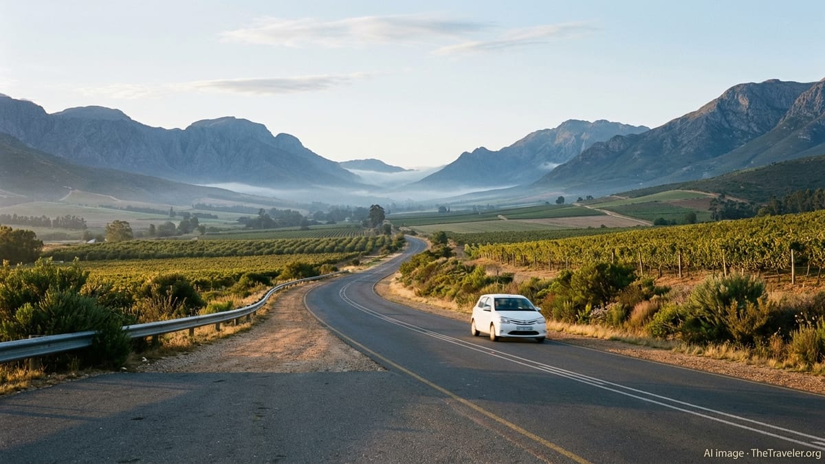
Nestled between rugged mountains and rolling vineyards in South Africa’s Western Cape, the small town of Wolseley is one of those places that reveals its charms most fully when you arrive under your own steam. With good regional roads, spectacular mountain passes and a cluster of wine farms and country escapes nearby, this is a destination that lends itself perfectly to a self-drive trip. Whether you are setting out from Cape Town, looping through the Boland and the Swartland, or using Wolseley as a springboard to explore Ceres and Tulbagh, travelling by car gives you the flexibility to meander, stop for farm-stall coffee and pull over for viewpoints whenever the landscape demands it.
Understanding Where Wolseley Fits in the Western Cape
Wolseley sits in the Witzenberg region of the Western Cape, close to the better-known towns of Ceres and Tulbagh. It lies just off the R46 regional route, which runs west towards Tulbagh and the Swartland and east over Michell’s Pass to Ceres. The R43 route begins on the same stretch of road and runs south towards Worcester before eventually heading for the Overberg coast. This road layout makes Wolseley a natural crossroads between the Cape Winelands, the Breede River Valley and the Koue Bokkeveld plateau beyond Ceres.
From Cape Town, Wolseley is roughly 120 to 130 kilometres inland by road, depending on your precise starting point and chosen route. In light traffic and normal conditions, most drivers cover the distance in about one and a half to two hours. The town is backed by rugged peaks and surrounded by farmlands, with higher mountain terrain rising to more than 2 000 metres in the broader area. This combination of accessible valley roads and dramatic relief is part of what makes driving in and out of Wolseley so rewarding.
Because Wolseley is small, with limited public transport and only a basic rail connection, a car is by far the most practical way to arrive and then move around. Local roads tend to be in reasonable condition, but they are predominantly single carriageway, often with narrow shoulders. Distances between fuel stops are not extreme, yet it is sensible to top up in larger centres such as Cape Town, Paarl, Wellington, Worcester or Ceres before you start detouring onto passes or gravel backroads.
Seasonal weather also shapes driving conditions around Wolseley. Summers are hot and dry, sometimes with high fire risk in surrounding fynbos and plantations. Winters bring rain, low cloud and occasionally snow on the highest peaks, which can affect visibility and traction on mountain passes. Planning your journey with local forecasts in mind will help you choose the safest and most scenic timing for your drive.
Driving from Cape Town to Wolseley
The vast majority of visitors reach Wolseley from Cape Town. Several viable road options exist, all paved and generally well signposted. The most direct approach involves taking the N1 national route out of the city towards Paarl and Worcester, then connecting with the R43 and R46 into Wolseley. The total driving distance is typically just over 120 kilometres, with a travel time of around 90 minutes in steady conditions, longer if you encounter weekday peak-hour traffic leaving Cape Town or crossing the Winelands corridor.
Leaving central Cape Town, the N1 climbs out past the northern suburbs and the Huguenot Tunnel corridor towards the interior. You pass near Paarl, one of the main Winelands towns, before continuing towards Worcester. Close to Worcester, signboards for the R43 point you off the N1 and onto the regional route that curves north through the Breede River Valley. The R43 then meets the R46 near the southern approach to Wolseley, where you follow signs into town.
An attractive alternative, particularly for those who want more scenery and are in no rush, is to route via Wellington and Bain’s Kloof Pass on the R301. This historic mountain pass, which links Wellington with the Breede River Valley, is celebrated for its dramatic cliffs and river views. From Cape Town you still begin on the N1 towards Paarl, but then turn off to Wellington and pick up the R301 over the pass, which later connects with the R43 near Wolseley. Although this route is a little slower, many self-drive travellers consider it one of the most memorable ways to arrive.
Whichever route you choose, it is good practice to check for any temporary roadworks, fires or pass closures on the day of travel. Bain’s Kloof in particular has seen periods of closure and controlled access due to maintenance and, at times, wildfire risk. Conditions can change quickly during the Cape’s summer fire season and winter storm period, so a quick look at updated mapping or regional traffic advisories before setting out is prudent.
Key Routes and Passes Around Wolseley
Once you are in Wolseley, the town’s position at a junction of regional roads makes it easy to fan out in several directions. To the west, the R46 leads towards Tulbagh and the Nuwekloof Pass, offering a gentle but scenic drive through farmlands framed by the Witzenberg and surrounding ranges. To the east, the same R46 climbs Michell’s Pass, a historic route through rocky slopes that ascends towards the fruit-growing hub of Ceres. Both passes have regular curves and changes in gradient, so unhurried, attentive driving is important.
South of Wolseley, the R43 heads first towards Worcester and then onward to other parts of the Western Cape. This section of road is less dramatically mountainous than the main passes but remains attractive, meandering through vineyards and farmland with mountain backdrops. It is also an important practical link, because Worcester offers more extensive services such as hospitals, major supermarkets, fuel stations and vehicle repair options that you might need on a longer road trip.
The R301 over Bain’s Kloof Pass is a highlight for many motorists who enjoy mountain driving and viewpoints. The road clings to the sides of the Limietberg range, with the river running below and steep drops beside you in places. The pass is paved but relatively narrow, and you will encounter tight bends, blind corners and occasional rockfall debris, especially after heavy rain or strong winds. While tourist vehicles, local traffic and cyclists all use the route, it is important to drive conservatively, keep an eye out for oncoming vehicles in the centre of the road and pull into designated lay-bys rather than stopping in unsafe positions.
Seasonal factors play a large part in how these routes feel to drive. In midsummer, heat shimmer, dry vegetation and bright sun can increase fatigue, making sunglasses, water and rest stops important. In midwinter, shaded sections of passes can remain wet and cold through the day, particularly after frontal systems. Visibility can drop quickly in low cloud or mist at altitude. Taking your time, using headlights where appropriate and being prepared to slow dramatically when conditions deteriorate will keep the journey enjoyable rather than stressful.
Planning Your Self-Drive: Cars, Navigation and Safety
For most visitors, a standard sedan or compact car is perfectly adequate for reaching Wolseley and exploring the surrounding area via the main paved routes. The R46, R43 and R301 are all surfaced, and while some access roads to farms, guesthouses or hiking areas may turn to gravel, they are generally driveable in two-wheel-drive vehicles when dry. A higher-clearance vehicle or small SUV can be more comfortable on corrugated surfaces, but is not essential unless you intend to spend significant time on backroads.
Navigation is straightforward thanks to clear route numbering and signposting, yet it is still wise to combine digital tools with common sense. Smartphone mapping applications provide good coverage in this part of the Western Cape, but cell signal can weaken in certain mountain sections and remote valleys. Downloading offline maps before you leave a major centre and carrying a basic paper map or printed directions as backup can prevent frustration if your device loses signal or battery power at a crucial junction.
Standard driving regulations for South Africa apply: driving is on the left-hand side of the road, seatbelts are mandatory, and the use of mobile phones while driving is restricted. Speed limits generally sit at around 120 kilometres per hour on major highways and 100 or 80 kilometres per hour on regional routes, dropping further through settlements and on sharp bends. Around Wolseley and the nearby passes, it is common to encounter slower-moving agricultural vehicles, heavy trucks and cyclists. Keeping a modest following distance and being patient when stuck behind slower traffic is safer than attempting risky overtakes on blind curves.
In terms of safety, many travellers drive these routes independently without incident. Nonetheless, basic precautions remain sensible. Avoid leaving valuables visible in a parked car. Try to plan long drives so that remote stretches are covered in daylight rather than late at night. In hot weather, carry extra water and ensure your car’s coolant and tyres are in good condition. If you are renting, inspect the vehicle carefully before departure and make sure you have a working spare tyre and jack, along with the emergency contact details of your rental company.
Exploring Wolseley and its Surrounds by Car
Having your own vehicle transforms Wolseley from a simple stopover into a base for wide-ranging exploration. Within a short drive you can access wine and olive farms, nature reserves, riverside picnic spots and small towns that each tell a different chapter of the region’s story. Many of these are strung along the R46 between Wolseley, Tulbagh and Ceres, making it easy to build relaxed day drives that loop out and back without long distances.
To the east, Michell’s Pass opens out towards Ceres, a town known for orchards, fruit juice production and mountain scenery. The pass itself offers viewpoints where you can safely pull off to admire the engineering and the layers of peaks in the distance. Continuing through Ceres, various side roads lead up into higher valleys and plateaus where hiking, mountain biking and farm stays are on offer. Conditions on these smaller roads vary from paved to gravel, so driving cautiously and checking road conditions locally before heading into more remote areas is advisable.
Heading west, the R46 brings you to Tulbagh, a historic town with an impressive array of restored Cape Dutch and Victorian buildings, particularly along its main heritage street. The roadway between Wolseley and Tulbagh is scenic rather than technically challenging, passing between vineyards and farmlands pressed up against mountain walls. Allow time to park and explore Tulbagh on foot, then perhaps extend your drive through Nuwekloof Pass towards the Swartland for wider valley views before returning to Wolseley.
To the south, the routes towards Worcester and Bain’s Kloof Pass reveal yet another side of the region. Worcester itself is a practical stop for provisions and services, but the backroads and passes nearby are where the driving becomes particularly memorable. Bain’s Kloof, when open, provides not just a link to Wellington and the Winelands but also access to picnic and swimming spots along the river. Parking is often in designated bays just off the road, after which short walks lead down to natural pools. Always park well clear of traffic lanes and obey any signage relating to fire risk, litter and safety.
Seasonal Considerations and Best Times to Drive
The Western Cape’s Mediterranean climate means that summers are typically hot and dry, while winters are cooler and wetter. For drivers heading to Wolseley and beyond, this has practical implications. Between about November and March, temperatures in the interior valleys can rise significantly during the day, and the landscape dries out. Heat can exacerbate driver fatigue and mechanical stress on vehicles, and peak fire season often coincides with this period. It is not uncommon for authorities to close certain passes for short periods if fire threatens the roadway or smoke severely reduces visibility.
By contrast, the months from late May through August bring cold fronts and rain. The mountains around Wolseley often catch more of this precipitation, and snow on high peaks is not unusual in midwinter. While the main passes generally remain open, heavy rain can lead to minor rockfalls, localized flooding in low-lying sections and slippery surfaces, especially on corners. Early morning and evening driving can coincide with fog or low cloud, which requires slower speeds, dipped headlights and increased following distances.
Spring and autumn stand out as particularly pleasant seasons for a self-drive visit. In spring, roughly from late August into October, temperatures are milder, snow lingers on the highest ridges and the surrounding countryside tends to be greener after winter rains. Fields and road verges may show seasonal flowers, especially in years with good rainfall. Autumn, from March into May, often brings stable weather, softer light and calmer winds, with vineyards taking on rich colours. These shoulder seasons balance decent road conditions with comfortable temperatures for exploring on foot once you park.
No matter when you travel, planning your driving schedule around daylight can make a big difference to both safety and enjoyment. The most scenic mountain sections are best appreciated in full light, and wildlife or livestock near rural roads are easier to spot before dusk. Checking sunrise and sunset times for the date of your trip and structuring your main driving legs accordingly will help you avoid long stretches of night driving on unfamiliar roads.
Practicalities: Fuel, Supplies and Local Services
Although Wolseley itself is small, it lies within a network of towns that provide all the essentials for a road-based holiday. Fuel stations are available in Wolseley and in nearby centres such as Ceres, Tulbagh and Worcester. That said, it is sensible to fill up in larger towns before exploring isolated backroads or venturing onto gravel detours where services are limited. Watching your gauge and topping up when you dip below half a tank, rather than pushing on until the low-fuel light comes on, is a good habit in rural areas.
For groceries and general supplies, Worcester and Ceres offer the broadest range of supermarkets and shops. Tulbagh and Wolseley provide more modest options, along with farm stalls and small convenience stores. If you are self-catering, doing a larger shop in one of the regional hubs at the start of your stay can save time and additional driving later. Many travellers combine supply stops with coffee breaks or meals in these towns, breaking up their driving days into manageable segments.
Mechanical assistance and medical services are chiefly clustered in Worcester and Ceres, with smaller facilities in towns like Tulbagh. Carrying a basic emergency kit in your car is still worthwhile. This might include a reflective triangle, a torch, a first-aid kit, water, snacks and a portable phone charger. In the event of a breakdown on a pass or a regional road, it is generally safer to pull as far off the carriageway as possible, switch on your hazard lights and call your rental company, roadside assistance provider or local emergency number for guidance.
Parking in and around Wolseley is usually uncomplicated. Most guest farms, lodges and small-town accommodations offer on-site parking. When stopping at viewpoints or river access points, use designated bays rather than informal shoulders where the surface may be unstable. In busy holiday periods, particularly over summer weekends and school holidays, popular picnic spots and river pools near passes can fill up quickly, so arriving earlier in the day reduces the chances of needing to park in awkward or potentially unsafe places.
The Takeaway
Reaching Wolseley by car unlocks a part of the Western Cape that is rich in scenery yet still relatively quiet compared with the busiest Winelands centres. The drive from Cape Town is short enough to be comfortable, yet long enough to feel like a genuine escape as the city gives way to vineyards, orchards and mountain passes. Once you arrive, the web of regional roads radiating from Wolseley makes it easy to explore in multiple directions, whether you are drawn to the heritage architecture of Tulbagh, the orchards of Ceres or the sweeping viewpoints of Bain’s Kloof.
With sensible planning around route choice, weather and daylight, driving in this region is straightforward for most motorists. A reliable vehicle, a flexible schedule and a willingness to slow down for curves, viewpoints and farm stalls are the main ingredients for a rewarding trip. Combined with the area’s mix of outdoor activities, culinary stops and rural tranquillity, Wolseley becomes more than just a dot on the map. It is a gateway to some of the Western Cape’s finest road-trip country, best experienced behind the wheel at your own pace.
FAQ
Q1. Is a standard two-wheel-drive car sufficient for visiting Wolseley and nearby attractions?
A standard two-wheel-drive sedan or hatchback is adequate for most visitors, as the primary routes to and around Wolseley are paved. You may encounter some gravel access roads to farms or hiking areas, but these are usually manageable in ordinary vehicles if you drive slowly and avoid them in very wet conditions.
Q2. How long does it take to drive from central Cape Town to Wolseley?
In typical conditions, the drive from central Cape Town to Wolseley takes around one and a half to two hours. Actual travel time depends on traffic leaving the city, your chosen route and how often you stop for viewpoints or breaks along the way.
Q3. Which is the most scenic driving route into Wolseley?
Many travellers consider the route via Wellington and Bain’s Kloof Pass particularly scenic, thanks to its combination of river gorges, mountain cliffs and valley views. The more direct N1 and R43 approach is also attractive but emphasizes efficiency over dramatic high-mountain scenery.
Q4. Are Bain’s Kloof Pass and Michell’s Pass open all year?
Both passes are generally open year-round, but they can experience temporary closures or restrictions due to roadworks, storms or wildfires. It is wise to confirm their status on the day of your trip using updated mapping tools or local traffic advisories.
Q5. Is it safe to drive in the Wolseley area after dark?
Many people do drive these roads after dark, but for visitors unfamiliar with the area, daytime travel is usually more comfortable. At night, it is harder to see bends, livestock or pedestrians, and emergency assistance can take longer to reach remote stretches.
Q6. Where should I plan to refuel when exploring by car?
Fuel is available in Wolseley itself and in nearby towns such as Ceres, Tulbagh and Worcester. For peace of mind, it is best to top up in larger centres, particularly before driving mountain passes or exploring side roads where services are sparse.
Q7. Do I need special permits to drive the main passes around Wolseley?
No special permits are usually required to drive the main public passes such as Bain’s Kloof or Michell’s Pass. Normal road rules apply, and it is important to obey posted speed limits, warning signs and any temporary instructions during maintenance or high fire-risk periods.
Q8. What is the best time of year for a road trip to Wolseley?
Spring and autumn are often the most pleasant seasons for a road trip to Wolseley, with milder temperatures and relatively stable weather. Summer can be very hot and prone to fires, while winter is cooler and wetter, with occasional mist and rockfalls on passes.
Q9. Is mobile phone reception reliable on the roads around Wolseley?
Mobile reception is generally good on main routes and in towns, but certain mountain sections and remote valleys can have weak or intermittent signal. Downloading offline maps and sharing your route plans with someone before you travel are sensible precautions.
Q10. Can I comfortably explore Wolseley as a day trip by car from Cape Town?
Yes, Wolseley can be visited as a long day trip from Cape Town, particularly if you leave early and return before dark. However, many travellers prefer at least one overnight stay so they can explore nearby towns, passes and countryside at a more relaxed pace.