
Circling Lake Superior is one of North America’s great road and shoreline journeys, linking three US states and one Canadian province in a single sweep of rugged cliffs, boreal forest, historic harbor towns, and long empty beaches. Planning a trip that crosses these borders and regions takes a bit more forethought than a typical weekend drive, but the payoff is a seamless experience of the world’s largest freshwater lake by surface area and the distinctly different cultures that ring its shores.
Understanding Lake Superior’s Regions and Road Network
Lake Superior’s shoreline stretches past Minnesota, Wisconsin, and Michigan in the United States, and Ontario in Canada. Travelers often envision it as one continuous coastal drive, but the reality is a patchwork of state and provincial highways, some hugging the water’s edge and others running inland before darting back to lake views. Thinking in regional segments helps make planning intuitive. Common trip frameworks include the full circle tour, which loops around the entire lake, and partial itineraries focused on the North Shore in Minnesota, Michigan’s Upper Peninsula, or Ontario’s wild central coastline.
The core driving network is relatively straightforward. In Minnesota, the North Shore Scenic Drive follows Highway 61 from Duluth northeast toward the Canadian border, linking a string of small towns and state parks. From Thunder Bay east across northern Ontario, the route transitions to the Trans Canada Highway, with long, remote stretches flanked by granite, forest, and shield country lakes. In Michigan’s Upper Peninsula, state and federal highways connect towns such as Marquette and Munising with more secluded coves and dunes, while in northern Wisconsin short spurs reach harbor towns that double as gateways to islands and coastal trails.
Because the shoreline is not a single uninterrupted road at the water’s edge, you will move between true coastal viewpoints and inland forest corridors many times each day. For a smooth experience, build your route with a mix of scenic pullouts, trailheads, and lighthouse stops, then use the inland stretches for transit between anchor towns. Cell coverage can be intermittent, particularly in rural Ontario and along quieter parts of the Upper Peninsula, so it is wise to download offline maps and keep printed directions or a paper atlas in the car.
Driving times between key towns can be longer than they look on the map due to two lane roads, construction zones, and weather. While Duluth to Thunder Bay or Sault Ste. Marie to Marquette are straightforward highway runs, they pass through areas prone to fog, sudden temperature changes, and wildlife crossings. Planning generous buffers between stops and identifying backup overnights or campgrounds will keep your schedule feeling flexible instead of rigid.
When to Go and How Weather Shapes Your Trip
Seasonality is one of the most important factors in planning a Lake Superior shoreline trip. Summers around the lake are generally mild compared with inland Midwest and Ontario heat, with many shoreline areas seeing daytime highs that are comfortable for hiking and evenings cool enough for a light jacket. The lake’s enormous volume moderates coastal temperatures, which means it can stay notably cooler near the water than just a few miles inland and spring can lag weeks behind interior regions. Travelers often remark on how a simple change in wind direction can make a warm afternoon feel suddenly brisk along the shoreline.
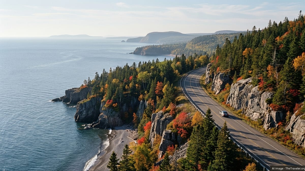
Autumn is widely considered one of the most rewarding times to circle Lake Superior. From mid September into October, hardwood forests in Minnesota, Michigan, Wisconsin, and Ontario shift through shades of red, orange, and gold, and crowds thin after the busy summer holiday period. Roads and parks typically remain open into late fall, though higher elevations and more northerly stretches may see frost or early snow. Fall storms are part of the lake’s lore, and while they can bring heavy waves and dramatic skies, they also require extra caution for shoreline walking and small craft.
Winter along the lake is beautiful but demanding, and it changes the basic logistics of travel. Ferry services, such as the Madeline Island connection between Bayfield and La Pointe, typically run only when ice conditions allow and shift to ice roads or specialized vehicles once the surface freezes sufficiently. State and provincial parks keep many trails open for snowshoeing and skiing, but short daylight hours, lake effect snow, and subfreezing temperatures make winter trips best suited to experienced cold weather travelers with proper gear and flexible plans. Shoulder seasons in late fall and early spring can mix thaw, freeze, and heavy fog in the same week.
If you are planning your first multi region shoreline trip, late June through early October is the most forgiving window. Early summer tends to bring longer days and high waterfalls fueled by spring snowmelt, while late summer and early fall offer warmer lake breezes and more stable road conditions. Whatever the season, plan to pack layers, including a windproof outer shell, because conditions can change quickly near the water, especially on exposed headlands or long bridge crossings.
Border Crossings, Documents, and Practical Logistics
Because a full Lake Superior shoreline loop crosses between the United States and Canada, you will need to plan around border formalities. Adult travelers should carry a valid passport or equivalent approved travel document. Citizens of some countries require visas or electronic travel authorizations for Canada or the United States, so verifying entry requirements well in advance is essential. If you are renting a car, confirm that your rental company allows cross border travel and that your insurance coverage remains valid on both sides of the lake.
Lake Superior crossings are typically handled at land ports of entry such as the one between Grand Portage, Minnesota, and the Thunder Bay region of Ontario, or the bridge crossing between Sault Ste. Marie, Michigan, and Sault Ste. Marie, Ontario. Wait times are usually manageable outside of peak holiday weekends, but they can still add an hour or more to your day. Build in extra time if you are crossing on Fridays, Sundays, or major summer and fall holidays, and keep snacks and water accessible in the vehicle.
Travelers with pets should check vaccination and documentation rules for both countries, as requirements for proof of rabies vaccination and pet health can differ slightly and may be updated periodically. If you plan to transport outdoor gear, such as canoes, kayaks, or camping equipment, be ready to answer routine questions about your plans and ensure you are not carrying restricted items like certain fresh foods or plants across the border. Many visitors plan their major grocery and supply stops around larger centers like Duluth, Thunder Bay, or Sault Ste. Marie to simplify these issues.
Time zones are a quieter but important logistical detail. Portions of the Lake Superior shoreline region observe different time zones, and daylight saving time observance can differ between US states and the Canadian province. Using a phone that automatically updates is convenient, but you should still verify local time when coordinating activities like guided boat tours, ferries, or park program start times. When booking lodging and activities, double check the time zone listed on confirmations so that sunrise photography sessions, dinner reservations, and check in times line up with your route.
Planning Your Route by Region
A practical way to plan a multi region Lake Superior shoreline trip is to divide the circuit into four segments and then decide how many days you want to devote to each. The southwestern shore centers on Duluth and the Minnesota North Shore, where a relatively short driving distance encompasses multiple state parks, waterfalls, and high viewpoints above the lake. This stretch rewards slower travel, with short hops between towns, frequent trailheads, and easy access to services and dining in hubs like Duluth and Grand Marais.
Continuing into Ontario, the route shifts to a more remote feel as you travel between Thunder Bay, smaller communities such as Marathon and Wawa, and eventually Sault Ste. Marie. Here the Trans Canada Highway threads through rugged rock cuts and forest with periodic long views over the lake. Visitor services are more widely spaced, so it makes sense to plan fuel, meals, and overnights with care. Ontario’s coastal parks, including large protected areas with long undeveloped shorelines, often lie a short drive off the main route and can serve as full day detours for hiking and beach time.
From Sault Ste. Marie west across Michigan’s Upper Peninsula, the personality changes again. Historic industrial and maritime towns meet wide sand beaches, sandstone cliffs, and dense forest. Towns such as Munising, Marquette, and Ontonagon provide access to scenic coastal drives, iconic lighthouses, and national lakeshore viewpoints. Because many of the most photographed viewpoints sit within protected areas that limit roadside parking, you will often leave the car and explore on foot or by boat.
Closing the loop through northern Wisconsin brings you through quieter harbor towns and small cities that serve as gateways to islands and coastal trails. Places like Bayfield on the south shore act as starting points for boat excursions and ferries, while nearby inland forests hold campgrounds and trail systems. The final leg back to Duluth or another starting point is a chance to revisit favorite shoreline stretches or detour inland to waterfalls and lakes that drain into Superior. By approaching the lake as four distinct but linked regions, you can build an itinerary that balances driving days with time spent out of the car.
Lodging, Camping, and Booking Strategy
Lodging around Lake Superior ranges from chain hotels and independent motels in larger towns to lakeside cabins, boutique inns, and extensive public campgrounds. On the Minnesota North Shore and in popular Upper Peninsula and Ontario parks, summer and fall weekends can book up well in advance. If your trip coincides with local festivals, school holidays, or peak fall color, consider reserving your key nights several months ahead, especially for waterfront properties or campgrounds with desirable views.
Public campgrounds in state, provincial, and national parks are a highlight for many shoreline travelers. These sites offer immediate access to beaches, cliffs, and forest trails, often within walking distance of the water. However, they can also be among the first to fill. Many park systems now use centralized online reservation platforms with rolling booking windows that open months before arrival. If you prefer a more spontaneous style, look for first come, first served campgrounds in less visited parks or plan weekday overnights, when demand is lower.
In more remote parts of northern Ontario and the Upper Peninsula, you may encounter longer distances between accommodations. In those stretches it is wise to identify at least two possible overnight towns per day and confirm that lodging is operating in the current season. Family run motels and cabins sometimes close or change hands, and small properties can fill up quickly when there is an event or local work project. Calling ahead, even for simple roadside motels, helps avoid long after dark drives in areas with active wildlife and limited lighting.
Travelers who prefer flexibility can mix pre booked anchor nights in hubs like Duluth, Thunder Bay, Sault Ste. Marie, and Marquette with more open days in between. This approach lets you adjust for weather, spending extra time on a sunny North Shore day or lingering in a favorite Ontario coastal park if the skies clear. Just remember that last minute options along particularly popular stretches, especially near major parks in peak season, may be limited or more expensive than bookings secured in advance.
Transport, Ferries, and Island Side Trips
Most Lake Superior shoreline trips rely on a private vehicle, whether your own car or a rental. The roads around the lake are largely paved and accessible in standard passenger vehicles during snow free seasons. Nonetheless, it is helpful to treat the lake’s circumference as a remote road trip rather than an urban commute. Check tire condition, carry a basic emergency kit, and be conservative with fuel stops in stretches of rural Ontario and the Upper Peninsula, where gas stations may be widely spaced or keep limited hours.
Ferry travel is a distinctive component of the Lake Superior shoreline experience, especially on the south shore. The Madeline Island Ferry Line, which connects Bayfield in northern Wisconsin with La Pointe on Madeline Island, generally runs multiple trips daily during open water seasons, with pedestrian, bicycle, and vehicle options. Schedules adjust throughout the year and operations are closely tied to weather and ice conditions, so travelers should verify current timetables before building same day connections or long detours around a specific crossing.
Beyond ferries, a variety of boat tours operate from shoreline towns during the warmer months. From Wisconsin harbors, narrated cruises offer views of offshore islands and lighthouses, while Minnesota and Michigan operators run sightseeing and photography tours that bring visitors close to cliffs, rock formations, and sea caves that are difficult to appreciate from land. On the Canadian side, charter operators and park affiliated services sometimes provide access to otherwise remote stretches of coast. These outings are highly dependent on lake conditions; strong waves, fog, or storms can prompt last minute cancellations, so it is prudent to schedule boat trips early in your stay to allow alternate days if needed.
If you are towing or transporting your own kayak or canoe, pay close attention to weather forecasts and local advice. Lake Superior’s cold water, fast changing conditions, and long fetch can surprise even experienced paddlers. Many shoreline visitors instead opt for guided trips with local outfitters who know how to read the lake’s mood and select safer routes in bays or behind islands. Whether traveling under your own power or by tour boat, always carry appropriate flotation gear and be prepared for temperatures that are significantly cooler on the water than ashore.
Culture, History, and Responsible Travel
Planning a shoreline trip around Lake Superior is not only about scenery. The communities that line the coast hold deep Indigenous histories, long maritime traditions, and layered stories of mining, forestry, and shipping. Duluth and Thunder Bay have museums and cultural centers that explore the lake’s role in regional development, while smaller towns around the shore showcase lighthouses, working harbors, and local art that reflects a close relationship with the water and surrounding forests. Building time for museum visits and local festivals into your itinerary turns a drive into a richer, more place based journey.
Many shoreline communities emphasize locally owned businesses, from cafes and breweries to galleries and outfitters. Seeking out local food, crafts, and guiding services spreads the economic benefit of tourism more evenly and often leads to more memorable encounters. Simple conversations with innkeepers, park rangers, and boat captains can yield insight into the lake’s changing conditions, from fluctuating water levels to storm patterns, and can point you toward less publicized trails or viewpoints that match your interests and abilities.
Lake Superior’s environment is both resilient and fragile. Its clear, cold waters are the result of a vast watershed and tight environmental protections, but shorelines and forests can still be strained by heavy visitation. When planning your trip, familiarize yourself with Leave No Trace principles and local regulations on fires, camping, and wildlife interaction. Stick to established trails where possible, pack out all trash, and respect posted closures intended to protect nesting birds, sensitive plants, or eroding cliffs.
Climate and environmental changes are visible along the lake, from shifting ice patterns and storm intensity to erosion along bluffs and beaches. Traveling responsibly includes being attentive to local advisories, supporting conservation focused organizations when opportunities arise, and approaching the lake with humility. Safety practices such as staying well back from cliff edges in high winds, respecting wave conditions on breakwalls, and being cautious around cold, fast moving rivers at spring melt also protect emergency responders and local communities that share the shoreline with visitors.
The Takeaway
A multi region Lake Superior shoreline trip is less about checking off attractions and more about finding your own rhythm around an immense body of water. Thoughtful planning around seasons, border crossings, road segments, and lodging can turn what might seem like a daunting circuit into a clear, flexible itinerary spread comfortably over a week or more. Dividing the lake into regional segments allows you to appreciate how the character of the shoreline shifts, from the dramatic headlands of Minnesota’s North Shore to the long undeveloped stretches of Ontario, the beach lined Upper Peninsula, and the island dotted harbors of Wisconsin.
As you move through these landscapes, small logistical choices add up. Booking key nights ahead but leaving space for serendipity, checking ferry and tour schedules against the season, and packing for conditions that range from warm sun to sudden cold winds will make long days feel easier. Equally important is the mindset you bring. When you slow down enough to watch fog roll across a cove or the sun rise over a quiet harbor, the lake’s scale and subtlety become clear.
In the end, the best planned Lake Superior shoreline trips are those that balance structure with openness. With sensible preparation and a willingness to adjust to the lake’s moods, you can craft a journey that feels both grounded and adventurous, connecting not only the physical shoreline but also the cultures and stories that have grown up around it on both sides of the border.
FAQ
Q1. How many days do I need for a full Lake Superior shoreline loop?
Most travelers allow 7 to 10 days for a relaxed full loop, which provides time for driving, hiking, and weather delays without rushing each regional segment.
Q2. Do I need a passport to drive the entire circle around Lake Superior?
Yes. A passport or other approved travel document is required to cross between the United States and Canada if you plan to complete the full international loop.
Q3. What is the best season for a first time Lake Superior shoreline trip?
Late June through early October is generally best, offering long daylight, more stable road conditions, and open park facilities while still avoiding the harshest weather.
Q4. Is it safe to camp around Lake Superior without reservations?
It can be, especially midweek or in less visited areas, but popular parks and waterfront campgrounds often fill, so reservations are recommended in peak summer and fall.
Q5. How challenging is winter travel around Lake Superior?
Winter travel can be demanding, with snow, ice, limited daylight, and changing ferry operations. It is best suited to drivers experienced in winter conditions and properly equipped vehicles.
Q6. Can I swim in Lake Superior during summer?
Yes, but the water remains very cold even in midsummer. Many visitors limit swims to brief dips in sheltered bays and always keep a close eye on wave and weather conditions.
Q7. Are there good options for traveling without a car?
Options are limited. Some segments offer regional buses or tour shuttles, but a car or organized tour is usually necessary for flexible access to shoreline parks and small towns.
Q8. How often do ferries like the Madeline Island route operate?
During ice free months, the Madeline Island ferry typically makes multiple trips daily, but schedules vary seasonally and depend on weather, so checking current timetables is important.
Q9. What should I pack for a summer Lake Superior road trip?
Pack layers including a warm sweater, windproof jacket, sturdy walking shoes, rain gear, sun protection, and a basic emergency kit, since temperatures and conditions change quickly.
Q10. Is it realistic to combine Lake Superior with other Great Lakes on one trip?
It is possible on a long journey, but Lake Superior alone easily fills a week or more. Focusing on Superior for one trip allows a deeper, less rushed experience of its shoreline.