
At the far northern tip of Michigan’s Upper Peninsula, the Keweenaw Peninsula narrows into a wind-battered finger of rock reaching into Lake Superior. Getting there requires commitment, but drivers who follow its northernmost roads are rewarded with empty shorelines, dense forest canopies, historic mining towns and some of the darkest night skies in the Midwest. This is a place where the pavement simply ends at the lake, the highway turns into a tunnel of trees, and a nine-mile ridge road can feel like the top of the world.
Understanding the Keweenaw’s Geography and Seasons
The Keweenaw Peninsula juts into Lake Superior from Michigan’s Upper Peninsula, with the twin cities of Houghton and Hancock serving as the practical gateway. From there, the land narrows into a long spine of rocky hills and forest before reaching Copper Harbor and the literal end of US 41, one of America’s great north–south highways. Distances are modest on paper, but the roads are winding, the weather highly variable and services surprisingly sparse once you leave the larger towns.
Lake Superior controls the peninsula’s climate. Spring arrives late, with lingering snowbanks and closed side roads often into May. Summers are generally mild and can be downright cool along the lakeshore, while inland forests feel slightly warmer and more humid. Autumn is primetime for color, when the birch, maple and aspen forests blaze with orange and gold. Winters are long, snowy and beautiful, but they shift the region into a different kind of destination best suited to experienced winter drivers.
Seasonality matters because some of the Keweenaw’s most beloved routes are not maintained year-round. Brockway Mountain Drive, the steep ridge road above Copper Harbor, typically opens for vehicle traffic in late spring once snow and ice have cleared and closes again by early winter, at which point it effectively becomes a snowmobile and ski route. Similarly, many forest and seasonal roads near the tip of the peninsula can remain muddy, rutted or snow-covered well into early summer, and they may be impassable for low-clearance vehicles after heavy storms.
As you plan your trip, build flexibility into your schedule. Road conditions can change quickly with lake-effect squalls, fog banks rolling off the water or late-season ice. Check regional tourism and road commission updates before driving long distances for a specific scenic byway, and always have a backup plan that keeps you on paved, state-maintained highways if the weather turns.
Getting to the Keweenaw by Road
Most visitors reach the Keweenaw Peninsula by car, approaching from the south or west through the broader Upper Peninsula before turning north at Houghton. From the Lower Peninsula, the most direct route is typically across the Mackinac Bridge, then west on US 2 or M 28 before angling north toward Houghton via US 41 or M 26. Travelers from Minnesota and Wisconsin often follow US 2 along the south shore of Lake Superior, then head north through L’Anse or Baraga toward Houghton.
Houghton and Hancock straddle the Keweenaw Waterway and are linked by the iconic Portage Lake Lift Bridge. This crossing marks a psychological threshold: once you drive across the bridge heading north, you enter the Keweenaw proper, with narrower roads, older mining towns and long stretches of forest. Both towns offer fuel, groceries, lodging and auto services; it is wise to top off your tank here and stock up on essentials before continuing.
US 41 and M 26 together form the peninsula’s primary north–south routes. They share pavement in places, split apart in others and offer slightly different experiences on the way to the tip. US 41 is the more direct highway and ultimately carries you to the very northern terminus at Copper Harbor. M 26 tracks closer to Lake Superior in sections, weaving through smaller communities and skirting wave-battered shoreline. Both are fully paved, state-maintained roads suitable for standard passenger vehicles in the warm seasons.
Regardless of the route you choose, budget more time than you would for similar distances in an urban area. Speed limits fall as you travel north, and the roads become curvier and more frequently lined with driveways, deer crossings and occasional logging trucks. Cell coverage is improving but can still be patchy, particularly in the forests north of Calumet. Download offline maps before leaving Houghton, and carry paper maps as backup if you plan to explore beyond the main highways.
Driving the Northernmost Highways: US 41, M 26 and Brockway Mountain
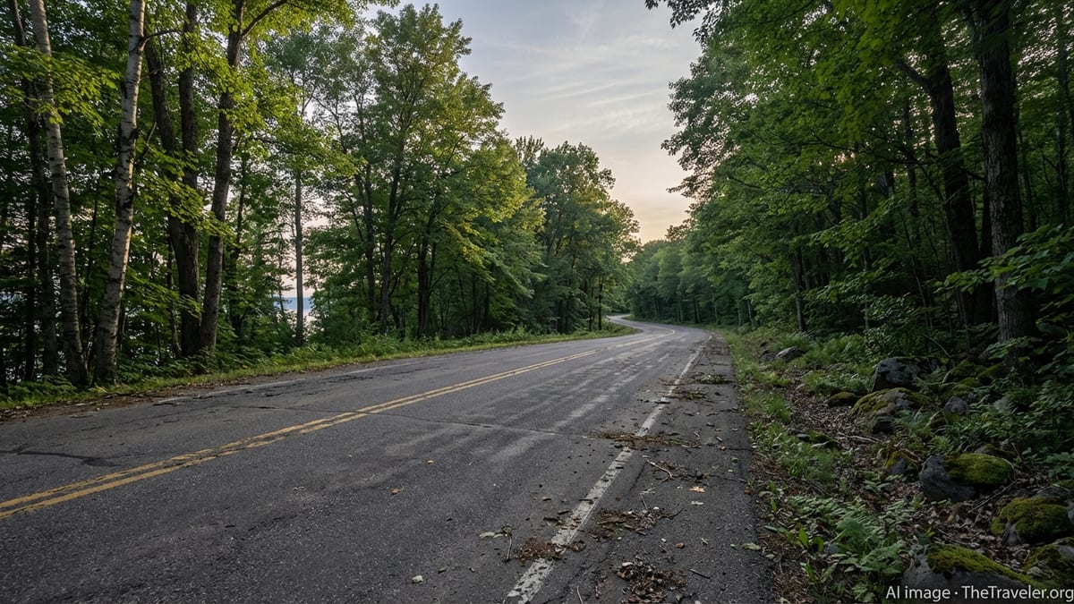
The last stretch of US 41 between Phoenix and Copper Harbor is one of Michigan’s signature drives. Here the highway narrows as it enters a dense “tunnel of trees,” where hardwoods arch overhead and the summer light filters green across the pavement. In autumn, these same trees create a blazing canopy of color. The road threads past small lakes, wetlands and rock cuts before easing into Copper Harbor, where a simple sign marks the northern end of the highway that begins over 1,900 miles away in Florida.
M 26 offers a contrasting experience as it hugs the Lake Superior shoreline in places. Between Eagle River and Copper Harbor, the highway passes roadside parks, small waterfalls and cobble beaches studded with wave-rounded stones. Pullouts allow for safe views of the lake’s shifting moods: on calm days it can glow Caribbean-blue, while in rough weather it heaves with cold gray surf. Even in high summer, the water is frigid, so treat it with respect and avoid scrambling on wet, algae-covered rock.
Brockway Mountain Drive, which climbs above Copper Harbor along a rocky ridge, is often the highlight for scenic drivers. When open to vehicle traffic in the warmer months, the nine-mile route rewards careful drivers with panoramic views over Lake Superior, forested hills and the small harbor town far below. The grades are steep, the pavement narrow and the curves sometimes sharp. Pullouts and parking areas dot the ridge so you can step out, feel the wind and watch weather systems sweep across the lake. In winter, the drive is not plowed and is instead used as a snowmobile corridor, so do not attempt to drive it once seasonal barriers are up.
If you are traveling by bicycle, be conservative about riding US 41 and Brockway Mountain Drive. US 41 has limited or no paved shoulder in stretches north of Calumet, and traffic can feel tight where forests meet the roadway. Brockway Mountain is steep with hairpin turns, and local outfitters often recommend using mountain bike trails or shuttle services instead of sharing the road with vehicles. Always wear high-visibility gear, use lights even during the day and ride single-file on these narrow sections.
Exploring Side Roads, Seasonal Routes and Remote Shorelines
Beyond the main highways, the Keweenaw is laced with gravel, dirt and seasonal roads that reach secluded coves, old mine sites and rocky points on Lake Superior. Many of these routes are unsigned, lightly maintained or unmaintained altogether. They are a large part of the region’s appeal, but they demand caution, patience and a willingness to turn around when conditions deteriorate.
Near the tip of the peninsula, rough roads lead toward remote places such as High Rock Bay and other isolated shoreline access points. In dry midsummer conditions, confident drivers in high-clearance vehicles may be able to navigate rocks, ruts and mudholes slowly, but after heavy rain or during spring thaw these tracks can become deeply rutted and potentially hazardous. Rental car agreements often discourage driving on unpaved or unmaintained roads, so read the fine print before venturing far from pavement.
Even inland, forest roads can feel more remote than their proximity to the highway suggests. It is easy to drive for half an hour without seeing another vehicle, and GPS apps sometimes show these routes as continuous when, on the ground, they are blocked by fallen trees, washouts or seasonal gates. Travel with a full tank, carry extra drinking water and snacks, and let someone know your plans if you intend to explore beyond major communities. In shoulder seasons, snow and ice can linger on shaded gravel tracks long after the main highways have cleared.
When in doubt, check in at visitor centers, ranger stations or local outfitters in towns like Copper Harbor, Calumet or Eagle River before committing to a long side trip. Local staff can provide current information about washouts, construction, private land boundaries and safe parking areas. Respect posted signs, avoid driving on soft, saturated ground that could deepen ruts, and leave room for other vehicles to pass or turn around on narrow dead-end roads.
Harbor Towns, History and Roadside Stops
Part of the pleasure of driving the Keweenaw’s northernmost roads is how frequently they deliver you into small towns and historic sites that feel worlds away from modern highway sprawl. South of the tip, Calumet retains impressive brick architecture and remnants of its copper-mining boom years, with historic buildings, old mine shafts and interpretive sites scattered along side streets and nearby back roads. It makes a logical base if you prefer a slightly larger town with services and a central location.
Further north along M 26, communities like Eagle River and Eagle Harbor cluster at natural harbors and river mouths. Roadside parks provide access to Lake Superior beaches where you can stretch your legs, skip stones and feel the full force of the lake’s wind. Short detours lead to waterfalls such as Eagle River Falls and others that plunge over volcanic rock close to the road, particularly dramatic during spring melt or after heavy rain.
Copper Harbor itself is more hamlet than town, but it is the emotional anchor of the peninsula’s northern tip. Summer brings a steady hum of travelers, mountain bikers and paddlers, yet the streets remain compact and walkable. From the harborfront, short drives lead to Fort Wilkins Historic State Park, where preserved 19th-century buildings recall the early years of the copper rush. Nearby trails connect to overlooks, lakes and river gorges, offering reasons to park the car and explore on foot.
Along the way, watch for low-key roadside businesses: rustic motels with neon signs, family-run restaurants catering to locals and travelers, seasonal ice cream stands and small markets. Hours can be limited outside of peak summer; it is sensible to confirm opening times in shoulder seasons and to carry basic snacks in your vehicle so you are not caught hungry on an empty stretch of road late in the evening.
Dark Skies, Outdoor Adventures and Getting Out of the Car
For all its remarkable roads, the Keweenaw is ultimately a destination best appreciated when you step away from the driver’s seat. The peninsula is home to an officially designated dark sky park headquartered at the Keweenaw Mountain Lodge near Copper Harbor, where lighting is managed to preserve nighttime darkness. On clear nights, stars explode overhead, the Milky Way arcs visibly across the sky and, during periods of solar activity, the northern lights occasionally ripple above Lake Superior.
Reaching these dark-sky viewpoints usually requires a short drive from town followed by a walk across fields, along ridge trails or around the lodge grounds. Because the area is intentionally kept very dark, it is smart to scout routes in daylight and to bring a red-filtered flashlight to preserve your night vision while minimizing glare for others. Warm layers, a hat and gloves can be essential even in midsummer nights, when temperatures drop quickly in the open clearings above Copper Harbor.
By day, the peninsula is crisscrossed with hiking and mountain biking trails that often begin right off the main roads. Trail systems near Copper Harbor, Brockway Mountain and the Keweenaw Mountain Lodge offer a range of experiences, from rocky, hand-built singletrack to smoother, machine-built descents. Signage and maps help visitors choose routes that match their ability, and local outfitters in Copper Harbor can provide rentals, shuttles and current trail conditions.
Water is another defining feature. Short drives from US 41 or M 26 lead to inland lakes for paddling, roadside waterfalls accessible via brief walks and cobble beaches where agate hunters scan the shore. When parking at these sites, be considerate of limited spaces, avoid blocking private driveways and be prepared for pit toilets or no facilities at all. Pack out everything you bring in, particularly at lightly managed roadside pullouts where trash service may be infrequent or nonexistent.
Safety, Weather and Responsible Travel on Narrow Roads
The remoteness that makes the Keweenaw so appealing also demands respect from drivers. Weather can shift rapidly. A sunny afternoon can turn into dense fog as cool lake air floods over warm pavement, and passing thunderstorms can produce sudden downpours that reduce visibility along narrow ridges and lakeshore stretches. Carry an extra layer, rain gear and an emergency kit in your vehicle, including jumper cables, a small shovel in winter and a basic first-aid kit year-round.
Wildlife is a constant presence along the northernmost roads. White-tailed deer frequently graze at roadside clearings, especially around dawn and dusk, and can dart into the roadway unexpectedly. Smaller animals such as foxes and porcupines occasionally appear after dark. Reduce speed when you see animal crossing signs or reflective eyes at the shoulder, and resist the urge to swerve sharply, which can be dangerous on narrow pavement without shoulders.
In winter, the Keweenaw becomes one of the snowiest regions in the Midwest, with lake-effect snow measured in many feet rather than inches. State highways are generally plowed and passable for vehicles equipped with proper winter tires, but side roads can be treacherous or closed altogether. Some summer-accessible lakefronts and trailheads are simply unreachable by car. If you are unfamiliar with heavy-snow driving, consider visiting in late spring through fall instead, or base yourself in Houghton and limit winter driving to well-maintained routes.
Responsible travel also means understanding your impact on small communities and fragile shorelines. Park only in established pullouts, do not drive onto beaches or vegetated dunes, and keep noise to a minimum in residential areas and after dark. Many of the most scenic viewpoints sit near private land, even if the access road is public. Respect fences and signs, leave gates as you find them and remember that for year-round residents, these narrow roads are daily commuting routes rather than simply scenic drives.
The Takeaway
Reaching the Keweenaw Peninsula and exploring Michigan’s northernmost roads is less about racing from point to point and more about adopting a slower rhythm. The journey from Houghton to Copper Harbor meanders through old mining towns, along wave-swept shores and up to a ridge that lifts you above Lake Superior itself. Paved highways such as US 41 and M 26 provide dependable spines for your trip, while gravel side roads, trailheads and shoreline pullouts invite careful detours.
With thoughtful planning, a flexible attitude toward weather and an appreciation for both the history and the wildness of this narrow peninsula, the drive becomes an experience in its own right. You will remember the feel of a tunnel of trees closing overhead, the hush of a dark-sky clearing far from city light and the way the road simply stops at the edge of the lake. In the Keweenaw, the end of the highway is not an endpoint at all, but a prompt to step outside the car and let the landscape set the pace.
FAQ
Q1. When is the best time of year to drive to the tip of the Keweenaw Peninsula?
The most reliable months for driving the northernmost roads are typically June through early October, when snow is gone, seasonal roads are more likely to be open and daylight hours are long. Late September and early October are especially popular for fall color, but expect cooler temperatures and the possibility of early frost.
Q2. Do I need a four-wheel-drive vehicle to explore the Keweenaw?
No, you do not need four-wheel drive to travel the main highways such as US 41 and M 26 or to reach Copper Harbor and most state parks in normal summer conditions. However, a high-clearance or four-wheel-drive vehicle is strongly recommended if you plan to explore rough seasonal roads near the tip of the peninsula, particularly after heavy rain or during spring thaw.
Q3. Is Brockway Mountain Drive open year-round for cars?
No. Brockway Mountain Drive is a seasonal road that typically opens to vehicle traffic in late spring once snow and ice have melted and closes again in early winter. During the snowy months it is not plowed and instead functions as a route for snowmobiles and other winter recreation, so drivers should not attempt to bypass seasonal barriers.
Q4. How much driving time should I plan between Houghton and Copper Harbor?
Although the distance is only around 50 to 60 miles depending on your route, it is wise to allow at least 75 to 90 minutes of driving time, not including scenic stops. The roads are two-lane, with varying speed limits, curves and frequent opportunities to pull off for views, small towns and waterfalls, all of which naturally slow the journey.
Q5. Will I have cell service on the northernmost roads?
Cell coverage is generally good in and near Houghton, Hancock and Calumet, and it exists in pockets up the peninsula, but it can be weak or nonexistent in forested stretches and around some remote shorelines. Download offline maps before leaving larger towns, share your plans with someone you trust and avoid relying solely on real-time navigation or messaging once you head north of Calumet.
Q6. Are there fuel and food options between Houghton and Copper Harbor?
Yes, but they are limited compared to more populated regions. You will find fuel and basic services in communities such as Calumet and a smaller selection closer to the tip, but options thin out quickly away from the main highways. It is sensible to start with a full tank in Houghton or Hancock, carry snacks and drinks in the car and not assume you can refuel late at night in the smaller towns.
Q7. Is it safe to drive the Keweenaw’s roads in winter?
It can be safe for experienced winter drivers equipped with appropriate tires and a well-prepared vehicle, especially on the main state highways, which are plowed and treated. However, lake-effect snow can be intense, visibility can drop quickly and many secondary and seasonal roads are unplowed or closed. If you are not used to heavy-snow driving, consider visiting outside the core winter months or limiting your travel to short, well-timed drives in daytime conditions.
Q8. Can I camp or sleep in my vehicle along the roadside?
Overnight camping is generally restricted to designated campgrounds, state parks and other approved sites. Sleeping in vehicles at highway pullouts, trailhead parking lots or dark-sky viewing areas may be prohibited or discouraged, and enforcement can vary by jurisdiction. Check current rules with state parks, local governments or visitor centers, and always adhere to posted signs regarding overnight parking.
Q9. What should I bring if I plan to stargaze in the Keweenaw?
Bring warm layers, including a hat and gloves even in summer, as temperatures drop quickly after dark near Lake Superior. A red-light flashlight or headlamp helps you see without spoiling your night vision or others’ viewing. A blanket or portable chair makes it more comfortable to watch the sky for extended periods, and if you plan to photograph the stars, research night-sky settings for your camera or phone before you arrive.
Q10. How can I explore without harming the Keweenaw’s environment or communities?
Stay on paved or established gravel roads, park only in designated areas or obvious pullouts and never drive onto beaches, dunes or fragile vegetation. Pack out all trash, keep noise low near homes and after dark, and respect private property and posted signs. Supporting local businesses, choosing locally owned lodging where possible and traveling outside of peak weekends can all help distribute the benefits of tourism more evenly across the region.