
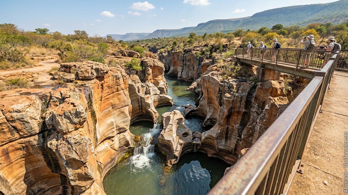
Carved by water and time into bands of orange, cream and rust, Bourke’s Luck Potholes are one of the signature sights of South Africa’s Panorama Route. Set at the confluence of the Treur and Blyde (now Motlatse) rivers, this network of cylindrical potholes, waterfalls and sculpted canyon walls lies within the Motlatse Canyon Provincial Nature Reserve in Mpumalanga.
For many travelers the challenge is not deciding whether to go, but how to fit a visit into a Kruger itinerary or a stay in Graskop. With a bit of planning, it is entirely possible to stand on the footbridges above the swirling pools on a relaxed day trip from either Kruger National Park or the small gateway town of Graskop.
Understanding Where Bourke’s Luck Potholes Fit Into Your Trip
Bourke’s Luck Potholes sit roughly midway along the Panorama Route, a scenic drive that runs along the rim of the Drakensberg escarpment between the Blyde River Canyon viewpoints in the north and the waterfalls and forested valleys around Sabie and Graskop in the south. The potholes mark the point where the Treur River plunges into the Motlatse River, and where the green canyon officially begins. The site is about 35 kilometers north of Graskop on the R532, and within manageable day-trip distance of several southern and central Kruger gates.
If you are based inside Kruger, the drive time will depend heavily on which gate you use. From Phalaborwa Gate on the park’s central-western side, it is around 159 kilometers by road to the potholes, which translates to roughly two hours forty minutes of driving once you are out of the park on regular roads, plus the time it takes to exit Kruger itself and clear formalities. From the southern gates such as Phabeni or Kruger Gate near Hazyview, many visitors prefer to combine the potholes with a full Panorama Route circuit, making a long but rewarding day that showcases mountains, waterfalls and lowveld views as a contrast to the bushveld of Kruger.
Graskop, by contrast, sits on the doorstep of the Panorama Route. With cafés, fuel, small supermarkets and a growing choice of guesthouses, it has evolved into the main overnight base for travelers focused on the escarpment. At just 35 to 37 kilometers from Bourke’s Luck Potholes, Graskop is ideal if you want a slower start, to visit at quieter times of day, or to slot the potholes into a broader self-drive exploration of the region without rushing.
Practical Details: Opening Hours, Fees and Facilities
Before planning a side trip from Kruger or a morning out from Graskop, it pays to understand how the site operates. Bourke’s Luck Potholes are managed as part of Motlatse Canyon Provincial Nature Reserve, and there is a formal entrance gate where you pay a per-person conservation and access fee. As of the 2024 to 2025 season, published rates for Bourke’s Luck Potholes distinguish between South African residents, visitors from other Southern African Development Community (SADC) countries and international tourists. For foreign visitors, expect to pay in the region of 150 rand per adult and about half that per child, with slightly lower rates for South African and SADC residents. Fees are periodically adjusted, so you should budget a little extra and confirm current tariffs locally when you arrive in Mpumalanga.
The attraction is generally open daily and operates during daylight hours, typically from early morning into late afternoon. Exact opening and closing times can vary with the season, but entry around 08:00 and a last admission in mid to late afternoon is common. Because the site lies in a mountain area where afternoon thunderstorms are frequent in the summer wet season, arriving earlier in the day is a wise move, especially if you are driving from Kruger. This allows you to enjoy the views in clearer conditions and build in time for a leisurely walk to the various viewpoints without worrying about long drives after dark.
On site, facilities are better developed than at many roadside viewpoints. There is a parking area for cars and tour buses, a small visitor center with displays that explain the geology and cultural history of the canyon, toilets, and a basic kiosk or café offering drinks and snacks. A craft market showcases locally made souvenirs and curios. The path network is designed for casual walking, with paved and gravel paths leading about 700 meters from the visitor center to the main footbridges and viewpoints. Allow an hour to ninety minutes for an unhurried visit that includes time to take photographs, read interpretive panels and simply watch the water swirl below.
Driving From Graskop: The Easiest Route to the Potholes
For most travelers, Graskop is the simplest and most flexible starting point for a visit to Bourke’s Luck Potholes. The town sits at the southern end of the Panorama Route, and the potholes are located a straightforward drive north along the R532. Road distance calculators and local tourism information give the distance as roughly 35 kilometers, with an estimated driving time of between 25 and 35 minutes depending on traffic, the performance of your vehicle and the number of stops you make along the way.
To reach the potholes from central Graskop, head north on the R532, following signs for Blyde River Canyon and Bourke’s Luck Potholes. This is a tarred, two-lane provincial road that climbs and dips along the rim of the escarpment. You are sharing the route with tour coaches, local traffic and occasional heavy vehicles, so it is important to drive cautiously, keep your speed down on blind corners, and allow faster vehicles to pass when it is safe to do so. In clear weather, the drive is scenic and straightforward, but in mist or rain visibility can drop quickly and you should use headlights and increase following distances accordingly.
One of the advantages of basing yourself in Graskop is the flexibility to fold other Panorama Route sights into the same outing. South of town you find the waterfall route leading to Lisbon and Berlin falls, while to the north the first major viewpoint is God’s Window, around nine kilometers out, followed by various other lookouts and forest trails. Bourke’s Luck Potholes are about 35 kilometers from Graskop along this same road, with the turn-off signed and the access road leading directly to the pay point and parking area. Continuing north beyond the potholes leads you to Lowveld View and the Three Rondavels viewpoint, which frames the northern end of the canyon.
Planning a Day Trip From Kruger National Park
Visiting Bourke’s Luck Potholes from Kruger requires more planning than a short hop from Graskop, but many travelers consider the detour a highlight of a longer safari. The key is to be realistic about distances and to account for the slower speeds and gate rules within Kruger. The park enforces strict speed limits and requires you to exit before the area gate closing times, which vary month by month. This means that a day trip that includes both game viewing and a Panorama Route excursion may be too ambitious unless you are staying in a camp close to a western gate and are prepared to spend much of the day on tar roads.
From Phalaborwa Gate, the distance to Bourke’s Luck Potholes is around 159 kilometers on public roads once you have exited the park. At average regional speed limits this translates into roughly two hours forty minutes of continuous driving. When you add the time spent traveling from your rest camp to the gate, clearing paperwork and possibly stopping for fuel or supplies, plus the return journey, you can see how a visit to the potholes becomes a full-day undertaking. For that reason, many itineraries use Phalaborwa as an exit point at the end of a Kruger stay, then add a night in or near the canyon rather than making a same-day out-and-back trip.
From the southern gates near Hazyview, the geography invites a loop that combines lowveld bush with escarpment scenery. Travelers leaving Kruger via Phabeni, Kruger or Numbi gates often drive to Hazyview, then follow the R40 to Sabie and on to Graskop, or go directly from Hazyview along the R536 and then the R532 to reach the Panorama Route. From Hazyview itself, road distance figures put the drive to Bourke’s Luck Potholes at about 90 kilometers, with a typical driving time of around one and a half hours. As with Phalaborwa, it is more comfortable to treat the potholes and associated viewpoints as part of a transition day between nights in Kruger and nights on the escarpment, rather than squeezing everything into a fast-paced return trip.
Sample Itineraries: Combining Kruger, Graskop and the Panorama Route
For a traveler starting in Kruger and wanting to include Bourke’s Luck Potholes without rushing, one of the simplest itineraries is to schedule a transfer day from the park to Graskop, then a dedicated Panorama Route day. For example, after a final early-morning game drive, you could exit Kruger via Phabeni or Kruger Gate late in the morning and drive to Graskop via Hazyview and Sabie, arriving mid-afternoon. This leaves time to check in, stretch your legs and perhaps visit the Graskop Gorge lift or a nearby waterfall before an early night.
On the following day, you could depart Graskop after breakfast and drive north along the R532, stopping first at God’s Window if the weather is clear, then continuing to Bourke’s Luck Potholes by late morning. An hour to ninety minutes at the potholes is usually sufficient for most visitors, leaving midday and early afternoon free to continue to Lowveld View and the Three Rondavels before looping back to Graskop. Alternatively, you could spend the evening further north near the Blyde River Dam if you prefer breaking the journey and exploring the canyon area in greater depth.
Travelers arriving from Johannesburg or Pretoria might invert this pattern. An early departure along the N4, then R36 and R532, brings you to the canyon area by early afternoon. Depending on your pace and interest, you could visit Bourke’s Luck Potholes on the way to Graskop or reserve them for the following day. After a full Panorama Route circuit, you would then drive down to Hazyview and enter Kruger via one of the southern gates for several days of safari. In each case, the potholes function as a natural anchor point within a broader landscape of cliffs, waterfalls and viewpoints rather than as an isolated destination.
On the Ground: What to Expect When You Arrive
Once you have paid at the entrance gate, you follow a short internal road to the main parking area. From here, a series of clearly marked, mostly paved footpaths lead you through low shrubland toward the rim of the canyon. The route passes a small visitor center where panels explain how the distinctive potholes were carved over many thousands of years by swirling pebbles and sand in the eddies where the two rivers meet. The paths are generally gentle and suitable for most reasonably mobile visitors, although there are steps and uneven sections that can be challenging for those with limited mobility.
The heart of the site is a cluster of pedestrian bridges that span the deeply scoured channels where the Treur and Motlatse rivers intersect. From these bridges you can look straight down into cylindrical potholes filled with greenish or amber water, their walls banded in shades of ochre, cream and black from mineral deposits and algae. In the wet season, water levels rise and small waterfalls and cascades pour through narrow rock chutes, adding sound and motion to the scene. In the drier winter months, flows are lower but the shapes of the rock formations are often easier to see.
Allow yourself time not just to take photographs from the obvious vantage points but also to explore the various side paths and railings, which reveal new angles on the rock formations and the canyon walls. In some sections you can look downstream into the broader Motlatse Canyon, while in others you can appreciate the intricate sculptures carved into the sandstone. Staying on the designated paths and behind safety barriers is essential. The rock can be slippery when wet, and the drop into the potholes is sheer in many places.
Seasonal Considerations, Safety and Responsible Travel
Mpumalanga’s escarpment has a subtropical climate with distinct wet and dry periods, and your experience of Bourke’s Luck Potholes will differ according to the season. In the summer months from roughly November to March, the region is warm and humid, with frequent afternoon thunderstorms. Rivers run higher, the surrounding vegetation is lush and green, and the potholes themselves may be partially filled, with stronger currents and more dramatic waterfalls. This can make for excellent photography, but also requires more care on wet surfaces and a willingness to adjust plans if low cloud settles over the escarpment and obscures views.
Winter, spanning roughly May to August, tends to be dry and cooler, with clearer skies and more stable conditions for driving and sightseeing. Daytime temperatures are pleasant, and visibility along the Panorama Route is often at its best, making it a prime period for combining Kruger safaris with canyon views. The trade-off is that water levels are lower, so the potholes may look less dramatic in terms of moving water, though their sculpted shapes might be more sharply defined. Shoulder seasons can be a mix of both dynamics and are often less busy than peak holiday periods.
Whatever the season, basic safety and responsible travel habits go a long way toward protecting both you and the fragile environment. Stick to marked paths and official viewing areas rather than trying to scramble onto unprotected rock ledges for a better selfie. Keep a close eye on children, who can be tempted by rocks and streams near the edges. Do not throw coins or litter into the potholes, and carry out all rubbish. Inside Kruger, respect speed limits and animal right-of-way on your way to or from the Panorama Route, and be aware that fatigue can creep in on days that combine long game drives with long road transfers.
The Takeaway
For travelers to northeastern South Africa, Bourke’s Luck Potholes are a natural complement to the wildlife of Kruger and the forests and waterfalls around Graskop. The site distills the drama of the escarpment into one compact, accessible stop: sculpted rock, plunging water, canyon views and a tangible sense of geological time. From Graskop, the potholes are an easy 35-kilometer drive on a tarred road, making them a simple addition to any Panorama Route day. From Kruger, a visit requires more careful timing and an honest assessment of distances, but pays off in striking contrast to the flat bushveld just a few hours away.
By understanding opening hours, current access fees, typical driving times and seasonal patterns, you can slot Bourke’s Luck Potholes into your itinerary without stress. Allow at least an hour on site, combine the visit with neighboring viewpoints along the canyon, and consider using Graskop or another escarpment town as an overnight base to avoid rushed out-and-back trips from the park. In doing so, you will give this remarkable confluence of rivers and rock the time and attention it deserves in your broader journey through Mpumalanga.
FAQ
Q1: How far is Bourke’s Luck Potholes from Graskop by road?
From central Graskop it is roughly 35 to 37 kilometers north along the R532 to Bourke’s Luck Potholes, with a typical driving time of about 25 to 35 minutes in normal conditions.
Q2: Can I visit Bourke’s Luck Potholes as a day trip from Kruger National Park?
Yes, it is physically possible, but it makes for a long day, especially from central or northern parts of Kruger. Many travelers prefer to exit Kruger, spend at least one night in Graskop or nearby, and then visit the potholes and other Panorama Route highlights on a separate, more relaxed day.
Q3: What are the current entrance fees for Bourke’s Luck Potholes?
Fees are structured by visitor category and are updated periodically, but as a guideline for the 2024 to 2025 period, international adults can expect to pay in the region of 150 rand per person, with lower rates for South African and SADC residents and for children. Always check locally for the latest tariffs before budgeting.
Q4: How long should I plan to spend at Bourke’s Luck Potholes?
Most visitors find that one to one and a half hours is enough to walk the paths, cross the bridges, read the interpretive displays and take photographs. If you like to linger, sketch or shoot extensively, you may be happier allowing up to two hours.
Q5: Is the site suitable for young children and older travelers?
The main paths are relatively short and gently graded, making the site accessible to most reasonably mobile visitors. However, there are steps, uneven surfaces and railings near drop-offs, so young children should be closely supervised and anyone with limited mobility may need to move slowly and choose routes carefully.
Q6: Which Kruger gate is best if I want to combine the park with the Panorama Route?
The southern gates near Hazyview, such as Phabeni, Kruger and Numbi, are often the most convenient for combining Kruger with Graskop and the Panorama Route, because they minimize public-road distances and allow you to structure a loop that includes both bushveld and escarpment scenery.
Q7: When is the best time of year to visit Bourke’s Luck Potholes?
Dry winter months from about May to August offer cooler temperatures, clearer skies and generally better visibility for views and photography. Summer brings lusher vegetation and stronger river flows but can involve heat, humidity, afternoon thunderstorms and occasional low cloud or mist along the escarpment.
Q8: Are there guided tours from Kruger or Graskop to Bourke’s Luck Potholes?
Yes, many lodges, guesthouses and safari operators in Hazyview, Graskop and around Kruger offer full- or half-day Panorama Route tours that include Bourke’s Luck Potholes, often combined with waterfalls and viewpoints such as God’s Window and the Three Rondavels.
Q9: Can I hike from Bourke’s Luck Potholes into the canyon?
There are longer hiking routes in the broader canyon area, and certain trails, such as day hikes starting near the potholes, may require permits from local tourism offices and early starts. Conditions and access rules can change, so you should inquire in Graskop or at the visitor center before planning any extended hikes.
Q10: Is it safe to drive the Panorama Route on my own?
For most visitors with normal driving experience, self-driving the Panorama Route is straightforward. Roads are tarred but can be winding and steep in places, so it is important to drive conservatively, avoid nighttime travel where possible, watch for sudden weather changes and give yourself enough time so you are not rushing between viewpoints or racing daylight back to your accommodation.