
Duncan, British Columbia is a compact, walkable city in the heart of the Cowichan Valley on Vancouver Island, roughly midway between Victoria and Nanaimo.
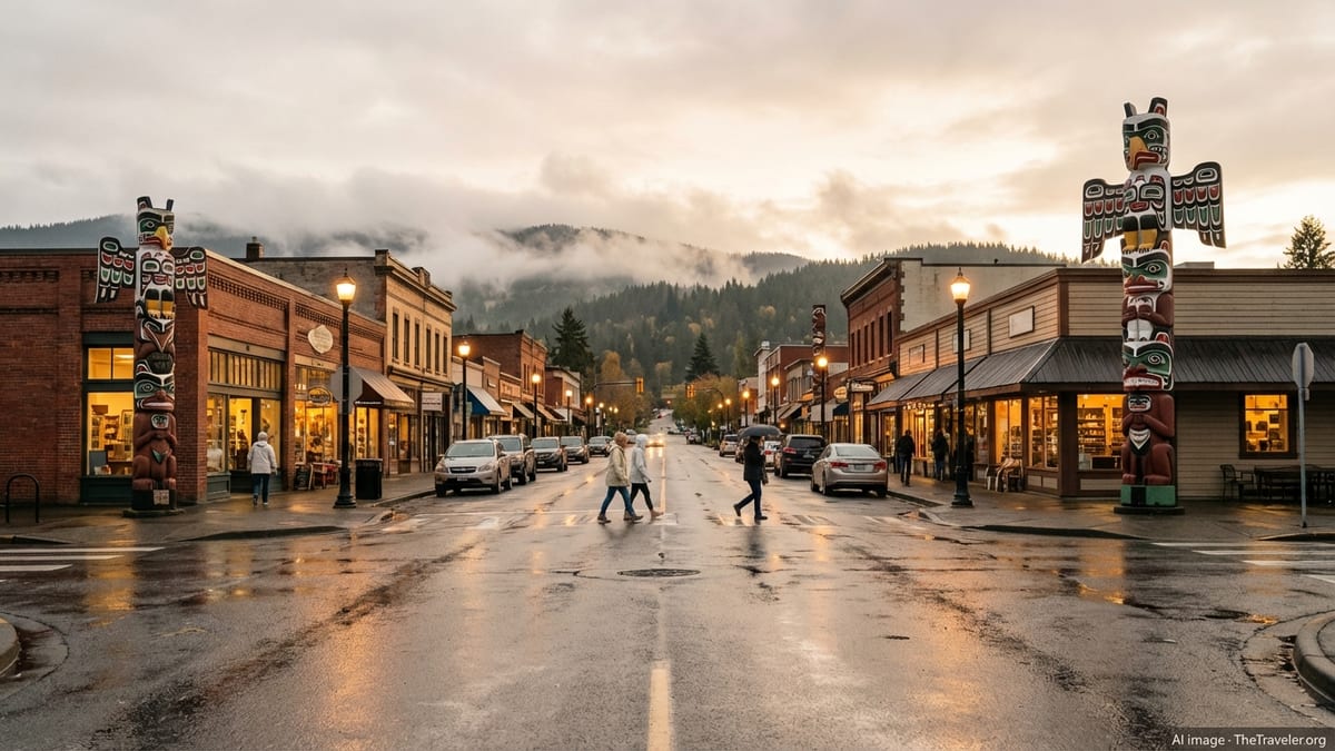
Known as the City of Totems and surrounded by farms, forests, wineries, and shoreline, it makes a relaxed base for exploring southern Vancouver Island.
This guide covers how to get to Duncan, how to get around once you arrive, and the essential planning details to help your trip run smoothly.
Understanding Duncan and the Cowichan Valley
Duncan sits just off Highway 1, the Island portion of the Trans Canada Highway, and functions as the main service hub for the Cowichan Valley. Although the city itself is small, it blends seamlessly into North Cowichan and nearby rural areas, so visitors often experience it as a single mid sized community stretched along the highway and the Cowichan River. For trip planning, this means that many services, accommodations, and attractions are within a short drive or transit ride even if they are technically outside Duncan’s municipal boundary.
The city centre is compact and pedestrian friendly, with most shops, cafes, and civic buildings clustered within a few blocks of the train station area and City Hall. Totem poles line many downtown streets, and there are several small parks and lanes that make walking a pleasant way to get oriented. Outside the core, commercial strips along Highway 1 and around major intersections host supermarkets, chain hotels, and large format stores that are easiest to reach by car, taxi, or bus.
The broader Cowichan region stretches from the Malahat summit north toward Ladysmith and west toward Lake Cowichan. Many visitors who say they are “going to Duncan” are really exploring this wider area of vineyards, lakes, and coastal bays. When you book accommodation or activities, check maps carefully so you understand how far your base will be from Duncan proper and what transportation options will be practical for your itinerary.
Because the climate is relatively mild, Duncan is a year round destination, but transportation patterns are strongly seasonal. Ferry sailings between Vancouver and Vancouver Island are busiest in summer and on long weekends, and seaplane routes typically add more daily flights during spring, summer, and fall. Public transit runs all year, but intercity routes operate on fixed timetables that can feel sparse compared with big city standards, so building in extra time and checking schedules before you travel is important.
Getting to Vancouver Island for Duncan
Most visitors reach Duncan by first traveling to Vancouver Island via ferry or plane. If you are coming from the Vancouver area with a vehicle, the usual approach is to take a BC Ferries sailing from Tsawwassen to Swartz Bay near Victoria, or from Tsawwassen or Horseshoe Bay to Nanaimo area terminals at Duke Point or Departure Bay. Once you disembark on Vancouver Island, Duncan is roughly a one to one and a quarter hour drive south of Nanaimo or north of Victoria, depending on traffic and road conditions.
Foot passengers can also use BC Ferries, but connecting to Duncan without a car requires a bit more planning. From Swartz Bay or the Nanaimo terminals, you can link to regional buses that connect into Victoria or Nanaimo, then transfer to intercity or regional transit services bound for the Cowichan Valley. If you travel this way, build in a generous buffer between your ferry arrival and your onward bus, as schedules do not always line up perfectly and delays on the water can cascade into missed connections.
For a faster but more expensive option, seaplanes link downtown Vancouver or the Vancouver airport area with Nanaimo Harbour on a year round basis, with flight times of about 20 minutes and several departures most days. Once you land in Nanaimo, you can rent a car, arrange a taxi or rideshare, or connect to transit for the roughly 60 kilometre journey to Duncan. Seasonal seaplane services also operate between other coastal communities and the Island; if your trip includes multiple coastal stops, combining ferries with a short scenic flight can save time and provide memorable views over the Strait of Georgia.
Travelers arriving from farther afield can fly into Victoria International Airport or Nanaimo Airport and then drive, shuttle, or bus to Duncan. Victoria’s airport, north of the city near Sidney, generally has more non stop routes and rental car options, while Nanaimo Airport offers a quieter experience and easy access to Highway 1 toward Duncan. In both cases, advance car rental reservations are recommended during peak periods, and checking for any schedule changes close to your departure date is wise given occasional adjustments by regional airlines.
Driving to and Around Duncan
For many visitors, especially those interested in wineries, lakes, and rural scenery, having a car is the simplest way to reach and explore Duncan. Highway 1 is the main corridor linking Victoria, Duncan, and Nanaimo. From Victoria, the route climbs the Malahat, a winding segment with viewpoints and occasional slowdowns due to weather, construction, or collisions. From Nanaimo, the highway runs more gently along the east coast of Vancouver Island before descending into the Cowichan Valley. Travel times in normal conditions are usually under 90 minutes from either city, but weekend congestion and summer roadwork can add delays.
Within Duncan, driving is straightforward, though traffic can back up around key intersections on Highway 1, particularly near the main commercial areas and at rush hour. Many accommodations provide free parking, and on street parking downtown often has time limits but is generally easy to find outside the very busiest times. If you plan to park for several hours while exploring on foot, look for public lots or clarify policies with your hotel or host so that you avoid tickets or towing.
Driving is also the most flexible way to explore surrounding attractions such as the Cowichan River, Cowichan Bay, Maple Bay, the Pacific Northwest Raptor Centre, and the wineries scattered across the valley. Distances are short in terms of kilometers, but travel can feel slower than the map suggests because most local roads are two lane, with lower speed limits through villages, curves, and school zones. Allow ample time for each leg and be prepared for occasional farm vehicles or cyclists sharing the road, especially on sunny weekends.
In winter, snow at sea level is relatively rare, but the Malahat summit and some higher rural routes can experience snow, ice, or heavy rain that reduces visibility. Before you set out from Victoria or Nanaimo, it is sensible to check provincial road condition reports and be sure your vehicle has seasonally appropriate tires. Even in good weather, driving at night in rural areas requires alertness for wildlife. Planning to complete most of your driving during daylight hours can make your trip both safer and more scenic.
Public Transit, Taxis, and Rideshares
Duncan is served by the Cowichan Valley Regional Transit System, operated in partnership with BC Transit and the regional district. Local fixed route buses connect Duncan with nearby communities such as North Cowichan, Cowichan Bay, Chemainus, and Lake Cowichan, while interregional routes offer express service to Victoria and connections toward Nanaimo. After a long labour dispute that shut down service for many months in 2025, buses resumed regular operations in October 2025, and current plans include expanded service on key express routes from early 2026 onward.
For visitors, this means that buses can again be a workable option for getting around the valley and making day trips, provided you are comfortable planning around published schedules. The Route 66 Cowichan Victoria Express links the region with downtown Victoria, and Route 70 connects Cowichan and Nanaimo, with some trips designed to provide timed transfers. Service levels continue to evolve, so for the most accurate information it is important to consult the official transit website or trip planning apps shortly before your travel dates rather than relying on older printed guides.
Within Duncan itself, local bus routes can help you travel between the downtown core, residential areas, and nearby communities, though frequencies are typically lower than in large cities. If your plans involve early morning departures, late evening events, or travel on Sundays and holidays, pay special attention to the timetable as service may be limited or not offered on certain routes at certain times. Given the recent disruptions, it is wise to build a backup option into your plans, such as a taxi or pre arranged ride, in case of unexpected cancellations or delays.
Taxis operate in Duncan and can be useful for transfers between downtown, hotels along the highway, and nearby attractions. They are also practical for short hops from transit stops to accommodations that are not directly on a bus route. App based rideshare options may be available at times but are not as ubiquitous as in larger centres, so do not rely solely on them. If you anticipate using taxis more than once or twice during your stay, storing the phone number of a reliable local company in your phone can save time.
Walking, Cycling, and Car Free Stays
Because downtown Duncan is compact, it is entirely feasible to enjoy a mostly car free stay if you choose accommodation within or close to the city centre. Once you are based there, you can walk to cafes, restaurants, shops, cultural venues, and key services, including banks and pharmacies. The City of Totems walking route highlights many of the carved poles around town, and several small parks and riverside paths make for pleasant short strolls. If you arrive by bus or are dropped off, choosing a centrally located hotel or guesthouse reduces your dependence on taxis for everyday errands.
Cycling is another practical way to explore Duncan and parts of the Cowichan Valley. Local roads range from quiet residential streets to busier highway segments, so route choice matters. Many cyclists stick to backroads and designated cycling routes where available, linking wineries, farm stands, and viewpoints at an easy pace. Multi use trails, including sections of the Cowichan Valley Trail that forms part of the larger Trans Canada Trail, offer scenic off road options, though access points may require short rides on regular roads. If you bring your own bike, be prepared for a mix of pavement and gravel and carry basic repair supplies.
Rental bikes or e bikes may be available through local outfitters, especially during the warmer months. If you are relying on a rental, consider reserving in advance for summer weekends or holiday periods when demand is highest. Helmets are required by law in British Columbia, and lights are essential if you will be riding at dusk or after dark. Locking your bike securely is important, particularly near busy commercial areas, just as it would be in any small city.
For visitors who prefer not to drive at all, a combination of walking, selective taxi trips, scheduled tours, and carefully planned transit use can cover many highlights. Wineries, cultural sites, and outdoor attractions often offer set tour times or transfers from central pickup points, particularly in peak season. When booking, ask operators about transportation options and whether they can accommodate travelers without cars. A realistic expectation of travel times and some flexibility in your schedule will make a car free trip both relaxing and workable.
When to Visit and How Long to Stay
Duncan’s climate is among the mildest in Canada, with relatively dry, warm summers and cool, wet winters. The most popular visiting period runs from late spring through early fall, when vineyards are in full leaf, local markets are busy, and outdoor activities on lakes, rivers, and coastal bays are most appealing. Summer brings the highest ferry traffic and the busiest days on regional highways, so reservations and a bit of patience are part of the experience. Shoulder seasons in May, June, September, and early October can offer a pleasant balance of good weather and lighter crowds.
Winter visits have their own appeal, with quieter streets, easier bookings at accommodations and restaurants, and a slower pace in the valley. Rain is common, so packing waterproof layers and footwear makes city walks and short hikes more comfortable. Transportation services tend to run on their regular schedules in winter, though storms can occasionally disrupt ferry sailings or cause slowdowns on the Malahat and other higher elevation routes. Building some flexibility into your itinerary can help you adjust if conditions change.
In terms of trip length, two to three days is usually enough for a first taste of Duncan and nearby highlights such as Cowichan Bay, a few wineries, and a local hike or two. If you want to add Lake Cowichan, multiple vineyard visits, more extensive trail time, or side trips to communities like Chemainus or Ladysmith, four to five days allows a more relaxed pace. Travelers who pair Duncan with Victoria or Nanaimo often allocate a week or more to the region as a whole, using Duncan as either a central base or a quieter second stop after time in a larger city.
When you plan your stay, also consider local events and peak weekends. Regional festivals, sports tournaments, and holiday long weekends can fill hotels quickly and add extra traffic on roads and ferries. Checking community calendars and booking transportation and lodging early for those periods is prudent. At the same time, these events bring a lively atmosphere to town, and transit agencies sometimes add extra service for major gatherings, which can be an advantage if you are trying to minimize driving.
Practical Trip Planning Basics
A bit of advance planning goes a long way toward making transportation in and around Duncan straightforward. If you are bringing a vehicle over from the mainland, reserving your ferry sailing is strongly recommended for summer, long weekends, and school holiday periods. Arriving at the terminal early reduces the stress of cut off times and potential delays. For walk on passengers, reservations are not always required, but checking expected sailing waits and considering off peak times can still make the journey smoother.
For those relying on public transit, the key is to think in terms of connections. Look at your arrival point, whether that is Swartz Bay, downtown Victoria, Nanaimo, or one of the airports, then map out how you will reach a Cowichan Valley transit connection or intercity bus. Online trip planners and apps that integrate BC Transit schedules can help you identify realistic transfer points and travel windows. Keep in mind that schedules may change seasonally and that temporary adjustments are possible after events such as labour disputes or service expansions, so confirm details within a few days of travel.
Accommodation location is another critical factor. If you plan to use buses or travel mostly on foot, choosing lodging within the walkable core of Duncan or very close to a major bus stop will save time and taxi fares. If you are focused on wineries or rural stays, a car becomes more important, though some tour companies offer door to door pickup from central hotels. In either case, asking your host or hotel about the nearest transit options, parking arrangements, and any local transportation quirks before you arrive can help you avoid surprises.
The Cowichan Regional Visitor Centre, located just off Highway 1 near the northern entrance to Duncan, is a useful first stop when you get into town. Staff can provide maps, current information on tours, transit, and driving conditions, and suggestions tailored to your interests. Visitor centre hours may vary by season, but on weekdays you can usually expect to speak with someone during standard business hours. Stopping in early in your trip can fine tune your plans based on whatever is happening locally during your stay.
The Takeaway
Visiting Duncan is as much about slowing down and settling into the rhythm of the Cowichan Valley as it is about checking off sights. Transportation is part of that experience. Whether you choose to arrive by ferry and car, land in Nanaimo on a seaplane, or stitch together a journey using buses and taxis, understanding how the different pieces connect will make your trip feel easy rather than complicated. The city’s small scale and its position between Victoria and Nanaimo mean that, with a bit of preparation, it can serve as a convenient hub for a wide range of island adventures.
By thinking ahead about how you will get to Vancouver Island, how you will move between communities, and where you will base yourself, you can match your transportation choices to the kind of trip you want. Drivers gain maximum flexibility for wineries and rural roads, while car free travelers can still enjoy a rewarding visit by focusing on downtown Duncan, carefully timed bus journeys, and occasional taxis or guided tours. In all cases, staying informed about current schedules and road conditions and giving yourself ample time for connections will keep your journey stress free.
Ultimately, the logistics of reaching and exploring Duncan are manageable, and the rewards are considerable. Between the totems and murals of downtown, the markets and vineyards of the valley, and the easy access to water and forest, this small city offers a lot within a relatively compact area. With transportation sorted out before you go, you can spend your days tasting, walking, and exploring rather than worrying about how to get from place to place.
FAQ
Q1. How do I get to Duncan from Vancouver without a car?
From Vancouver you can sail as a foot passenger to either Victoria or Nanaimo, then connect by regional bus and Cowichan Valley transit or an intercity coach to Duncan. Because schedules change, check ferry and bus times close to your trip and allow extra time for transfers between services.
Q2. Is it possible to visit Duncan as a day trip from Victoria?
Yes, many people visit Duncan as a day trip from Victoria by driving Highway 1 over the Malahat or using the Cowichan Victoria express bus when it is running. Travel time each way is usually around 60 to 90 minutes, not including any delays, so starting early gives you more time in town and in the surrounding valley.
Q3. Do I need a car to enjoy Duncan and the Cowichan Valley?
You do not strictly need a car if you stay in downtown Duncan and focus on walking, local attractions, and occasional taxis or tours. However, a car makes it much easier to reach wineries, lakes, and rural viewpoints, so travelers interested in exploring widely across the valley often find driving the most convenient option.
Q4. What is the status of public transit in Duncan right now?
After a prolonged labour dispute that shut service down in 2025, Cowichan Valley buses resumed in October 2025 and are currently operating, with plans for expanded express service. Because routes and frequencies may evolve, it is important to consult current schedules and service alerts shortly before you travel rather than relying on older information.
Q5. How long should I plan to stay in Duncan?
A two or three night stay works well for first time visitors who want to explore downtown Duncan, see some totems, visit nearby Cowichan Bay, and perhaps stop at a winery. If you want to add Lake Cowichan, more extensive hiking or cycling, and additional side trips, four or five nights allows a more relaxed and varied itinerary.
Q6. When is the best time of year to visit Duncan?
Late spring through early fall offers the warmest weather, the fullest schedule of outdoor events, and the best conditions for vineyards and water activities. Winter is quieter, cooler, and wetter but can be appealing for travelers who prefer a slower pace and easier bookings, provided they pack for rain and shorter daylight hours.
Q7. Is Duncan walkable for visitors without mobility challenges?
Yes, the central part of Duncan is very walkable, with shops, restaurants, services, and cultural sites concentrated within a few blocks. Sidewalks are generally good, though the terrain rolls a little in places, and some attractions outside the core still require a drive or a longer walk, so checking distances in advance is helpful.
Q8. How far is Duncan from Victoria and Nanaimo?
Duncan is roughly 60 to 65 kilometres from both Victoria and Nanaimo along Highway 1, with typical driving times of about one to one and a quarter hours in normal conditions. Actual travel time can be longer during peak holiday traffic, roadwork, or poor weather, especially on the Malahat section south of Duncan.
Q9. Are there bike friendly routes in and around Duncan?
There are several bike friendly options, including quieter backroads linking farms and vineyards and multi use paths such as sections of the Cowichan Valley Trail. Some routes involve sharing space with vehicle traffic and occasional hills, so choosing your route carefully, riding with lights and helmets, and allowing extra time will make cycling more enjoyable.
Q10. Where can I find local help with trip planning once I arrive?
The Cowichan Regional Visitor Centre near the highway on the north side of Duncan is a good first stop for maps, current event information, and tailored advice. Staff there can help you understand local transportation options, recommend routes and attractions suited to your interests, and point you to services such as bike rentals or guided tours.