
Hubbard Glacier has a way of making even the biggest cruise ship feel impossibly small. Its towering ice walls crack, thunder and collapse into the sea in a show so powerful it can be felt through the soles of your feet.
At more than 70 miles long and over six miles wide where it meets the ocean, this is the largest tidewater glacier in North America and one of the most dramatic natural spectacles you can see from a ship anywhere in the world. This guide explains what makes Hubbard Glacier so massive, how it behaves, and exactly what you can expect to see on a visit today.
Where Hubbard Glacier Is and Why It Matters
Hubbard Glacier straddles the border of eastern Alaska and Canada’s Yukon, flowing out of the immense icefields around Mount Logan in Kluane National Park and descending to sea level in Wrangell–St. Elias National Park and Preserve. Its icy front meets the ocean in Disenchantment Bay near Yakutat, a remote stretch of the Gulf of Alaska visited almost exclusively by ships and flightseeing planes. For most travelers, this isolation only adds to its sense of scale and wildness.
The glacier is what scientists call a tidewater glacier, meaning it flows all the way from the mountains down into saltwater. Those ocean-facing cliffs of ice are what cruise passengers come to see. Here, the glacier’s face is typically about 300 to 400 feet high above the waterline, with several times that depth hidden beneath the surface. In places the active ice front curves across more than six miles, forming a broken blue and white wall that dominates the head of the bay.
Hubbard is also a transboundary glacier. Its upper reaches lie in Canada, while its lower tongue and calving face sit in Alaska. That location connects two of North America’s great protected areas: Kluane National Park and Reserve on the Canadian side and Wrangell–St. Elias National Park and Preserve in the United States. Together with neighboring parks, they form one of the largest protected mountain and icefield complexes on Earth. Seeing Hubbard is, in a sense, witnessing the beating heart of this larger glacial system.
For Indigenous Tlingit communities, the glacier is not just scenery but part of a living cultural landscape. Known in Tlingit as Sít’ Tlein, meaning something close to “big glacier,” it has shaped local hunting grounds, travel routes and stories for generations. When you arrive in Disenchantment Bay, you are stepping into a place that has been under active ice, open sea and freshwater lake at different points in recent history, all because of Hubbard’s shifting front.
How Massive Is Hubbard Glacier Really?
Statistics can only go so far in conveying Hubbard’s size, but they help explain why it feels so overwhelming from the deck of a ship. The glacier is roughly 76 miles, or about 120 kilometers, long from its high mountain origins to its terminus at sea level. Its overall area is on the order of 2,400 square kilometers, making it not just the largest tidewater glacier in North America but one of the largest outside the polar ice sheets.
At the ocean, the visible ice cliffs often soar 300 to 400 feet above the water. That is the height of a 25 to 35 story building. Yet only about one-seventh to one-eighth of a floating ice face sits above water, so the actual ice thickness at the front can easily exceed 1,500 to 2,000 feet. In some interior sections, the ice is even thicker, compressed by centuries of snowfall and glacial flow.
The width of the calving front is equally staggering. The active face curves across more than six miles where it meets Disenchantment Bay and the entrance to Russell Fjord. Because the terminus is not a flat wall but an irregular line punctuated by inlets and protrusions, different sections calve and advance at slightly different rates, giving the front its jagged and visually complex character.
Another way to understand its mass is time. Ice that you see at the face of Hubbard today likely began its journey as snow high on Mount Logan’s flanks about 400 years ago. Over centuries, that snow compacted into ice and slowly crept downhill, channeled into a vast, slow-moving river of frozen water. When a block finally breaks free with a roar and crashes into the sea beside your ship, you are watching the end of a process that started before the age of modern maps in this region.
Why Hubbard Glacier Is Still Advancing
One of the most intriguing aspects of Hubbard Glacier is that it is advancing, not retreating. While the overwhelming majority of glaciers in Alaska have thinned and receded over the past century, Hubbard has thickened and pushed forward at its lower reaches. This apparent contradiction has made it a focus of scientific research and a prime example of how tidewater glaciers can behave differently from expectations based purely on air temperature trends.
Glaciologists describe Hubbard as part of a tidewater glacier cycle. In this cycle, a glacier that flows into the sea can spend long periods steadily advancing, even in a warming climate, because changes at its ocean front govern its behavior as much as air temperature. If the submarine topography beneath its face provides a stable platform, or if underwater moraines build up and buttress the ice, the glacier can hold a thick, tall front that resists rapid break-up. In Hubbard’s case, bathymetric measurements and long-term monitoring have shown significant thickening and a slow but persistent push forward over many decades.
Measurements taken in the second half of the twentieth century found that the lower parts of Hubbard Glacier had gained tens of meters in thickness over a few decades, and that its terminus had advanced at average rates on the order of tens of meters per year. While those exact values fluctuate seasonally and from year to year, the general pattern has continued into the twenty-first century. The result for visitors is a glacier that still presents a high, vigorous ice front rather than a stagnant, collapsing cliff.
This does not mean Hubbard is immune to climate change. The icefield that feeds it, like most in the region, is sensitive to long-term shifts in snow accumulation and melt. Over centuries, those shifts will influence how much ice ultimately reaches the sea. For now, however, Hubbard’s particular configuration, combined with its underwater support and the mechanics of its calving front, have allowed it to remain a rare advancing giant in a region where most glaciers are in retreat.
A Glacier That Can Re-Shape the Coastline
Perhaps the most dramatic sign of Hubbard Glacier’s power is its ability to re-engineer the local geography in real time. At the eastern side of its terminus, the glacier reaches across a narrow channel that connects Russell Fjord to Disenchantment Bay. When the ice and its underwater moraine push far enough, they can close this channel, sealing off Russell Fjord from the ocean and creating a large glacier-dammed lake.
That is not a theoretical future outcome but something that has already happened twice in recent decades. In 1986, Hubbard surged and blocked the fjord’s outlet, causing the water level in what became known as Russell Lake to rise as freshwater inflow far exceeded the small amount seeping through the ice barrier. Over the course of months, the level climbed scores of feet above sea level. Eventually, the dam failed in a sudden outburst, sending a massive release of water and ice back into the ocean channel.
A similar closure occurred again in 2002, demonstrating that Hubbard is capable of repeating this cycle. Each time, the temporary lake expanded until the pressure of the higher water column and the erosive power of the outflow carved through the ice and sediment. The process posed potential risks to the nearby community of Yakutat because a much larger and more sustained closure could, in principle, raise water levels high enough to alter river systems and flood low-lying areas around the fjord.
Today, scientists closely monitor Hubbard’s advance and the evolving shape of the underwater moraine near Russell Fjord’s mouth. For travelers, this slow-motion engineering project underscores how alive the glacier is. The smooth, fjord-carved mountains you admire as your ship enters Disenchantment Bay have been sculpted by cycles of ice advance and retreat over thousands of years. Hubbard’s modern surges and closures are just the latest chapter in that ongoing story of landscape transformation.
What You Will Actually See on a Hubbard Glacier Visit
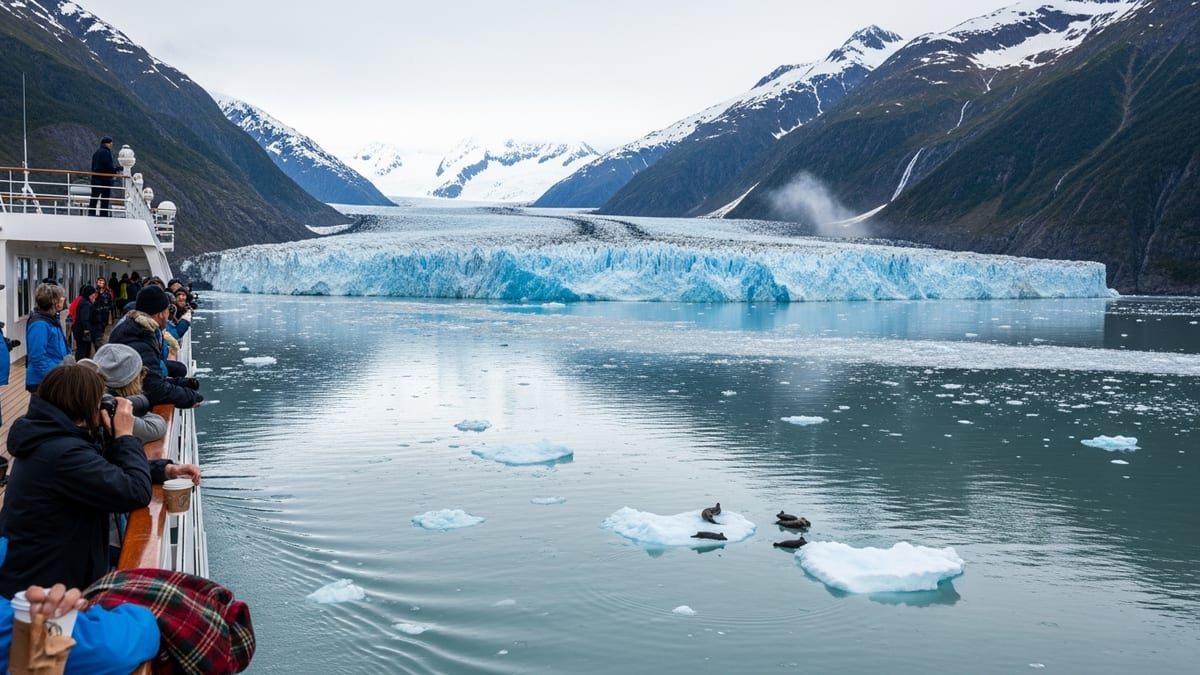
Reading about Hubbard’s statistics is one thing; approaching it by ship is another. Most visitors experience the glacier on an Alaska cruise that includes scenic cruising in Yakutat and Disenchantment Bays. On a typical approach, your ship spends hours gliding up Yakutat Bay, with mountains rising higher and higher on either side as you near the ice-draped skyline of the St. Elias Range.
As the ship turns into Disenchantment Bay, the air grows noticeably colder and fresher, especially if a light breeze blows off the ice. Bits of floating brash ice appear first as pale specks on the water, then as larger chunks with a characteristic glassy blue sheen. Seals sometimes haul out on flat floes, and seabirds patrol the channel, diving where currents concentrate krill and small fish. In clear weather, the serrated ridges behind the glacier come into full view, streaked with snow and flanked by smaller valley glaciers.
Once the captain has navigated through the denser ice near the head of the bay, the ship slows or stops to give everyone time to absorb the sight of Hubbard’s face. Large cruise ships generally hold a safe distance that can range from roughly half a mile to a mile or more, depending on ice conditions. If icebergs from recent calving events spread too widely, the vessel will remain farther out. Many captains slowly rotate the ship so that both port and starboard passengers enjoy unobstructed views, and some will complete a full 360-degree turn if conditions allow.
Visually, the glacier is a complex patchwork of ice textures. Some sections appear smooth and pale, sculpted into rounded forms by flow and melt, while others crack into sharp spires and towers known as seracs. Freshly fractured surfaces shine with intense blue color, a sign of dense, bubble-poor ice that absorbs more of the red portion of sunlight. Dark lines of rock debris trace through the surface where tributary glaciers have joined, creating lateral and medial moraines that mark different flow channels within the overall river of ice.
The Drama of Calving: Sound, Motion and Ice
What many travelers remember most vividly from Hubbard Glacier is not just what they saw, but what they heard and felt. Calving is the process by which chunks of ice break off the glacier’s front and tumble into the sea. At Hubbard, these events can range from modest collapses to major blocks the size of multi-story buildings falling away in a single, thunderous moment.
On deck, you will likely hear what locals sometimes call “white thunder” long before you locate the exact source of a calving event. The sound begins as a deep crack or boom that echoes off the surrounding cliffs, followed by a rolling rumble as ice shatters and bounces. Only after this sonic warning will you see the plume of ice and snow cascades at the glacier’s face. Light travels much faster than sound, but the complex acoustics of the bay and your distance from the ice mean your ears still lag behind your eyes when it comes to pinpointing the action.
When a large block of ice breaks free and plunges underwater, it displaces an immense volume of seawater. That motion generates rolling waves that radiate outward and jostle nearby ice floes. Newly submerged ice rapidly bobs and rolls, and sometimes entire bergs that had been floating hidden-side-down suddenly rotate to reveal intensely blue, sculpted undersides. From the safely distant deck of a cruise ship, you may feel a gentle lift and roll beneath your feet as those swells reach you.
Calving at Hubbard is not constant, but it is frequent enough that patient observers almost always see multiple events during a typical viewing window. Warmer afternoon temperatures and falling tides can sometimes increase activity, although the exact timing is governed by complex internal stresses within the ice. Captains often linger for an hour or more within viewing distance so that guests have repeated chances to witness these dramatic moments.
Wildlife and Natural Highlights Around the Glacier
While Hubbard Glacier is the star attraction, the surrounding waters and shorelines offer their own quiet spectacles. The cold, fresh meltwater pouring from the glacier’s face mixes with saltwater to create nutrient-rich conditions that support plankton blooms, fish and the animals that feed on them. As your ship navigates the bay, watch for marine mammals and birds that depend on this dynamic environment.
Harbor seals are among the most common wildlife sightings near tidewater glaciers in Alaska. They often rest on floating ice, using the bergs as safe haul-out platforms away from many land-based predators. In late spring and early summer, females give birth and nurse pups on these ice floes, taking advantage of the relative safety of the glacial environment. Binoculars or a camera zoom lens will help you spot their sleek bodies and the smaller shapes of pups lying nearby.
Birdlife can be equally engaging. Black-legged kittiwakes, gulls and other seabirds swirl above the ice edge, occasionally forming dense flocks where currents concentrate food. Bald eagles sometimes perch on ice or low rock outcrops, watching for fish near the surface. On the fjord walls, you may notice waterfalls fed by hanging glaciers and snowfields, tumbling down steep rock faces into the bay below.
On rare, exceptionally clear days, you may also catch distant views of some of the region’s high summits. Mount St. Elias and Mount Logan, two of the tallest peaks in North America, rise within the broader mountain chain that feeds Hubbard’s icefield. Even when clouds partially obscure them, their sheer bulk is evident in the scale of the surrounding ridges. These mountains collect the heavy snowfall that ultimately compresses into the glacier you see calving at your feet.
Planning Your Visit and What to Expect
Most travelers reach Hubbard Glacier on large cruise ships operating the Gulf of Alaska or one-way routes between southcentral Alaska and Southeast Alaska. Some itineraries list “scenic cruising at Hubbard Glacier” as a dedicated day, while others combine it with port calls in towns such as Yakutat or nearby coastal communities. When comparing trips, pay attention to how much time is allocated in the bay and in which months the line typically visits.
The core cruise season for Hubbard Glacier generally runs from late spring through early fall. May and June can bring clearer skies and cooler temperatures, with crisp visibility but still-snowy mountains. July and August are often milder on deck but can be cloudier or wetter, with more variable weather patterns. Early fall voyages in September can encounter stronger storms in the Gulf of Alaska but may reward passengers with dramatic light and fewer ships in the area. Ice and weather conditions always dictate how close any vessel can safely approach.
On board, expect the ship’s crew to treat a Hubbard Glacier visit as a marquee event. Naturalists or guest speakers often provide commentary over the public address system, describing glacial processes, local wildlife and the history of research in the region. Hot drinks and blankets may appear on deck to keep guests comfortable in the chill air. Photography enthusiasts will crowd railings and observation decks, but the ship’s rotation usually ensures that you can find a good vantage point if you are patient.
What you should not expect is any opportunity to walk on the glacier or go ashore at its face as part of a standard large-ship itinerary. The combination of deep water, unstable ice cliffs and actively calving fronts makes close landings both logistically difficult and unsafe. Specialized expedition voyages or chartered small boats in the region may offer more intimate perspectives, but these still observe careful distances from the active ice. For most visitors, the experience is one of extended, close-range observation rather than direct contact.
The Takeaway
Hubbard Glacier is massive in ways that are both measurable and indescribable. Measured in miles and meters, it is the largest tidewater glacier in North America, an advancing river of ice that has reshaped bays, blocked fjords and carved deep into the spine of the St. Elias Mountains. Measured in experience, it is the echoing boom of calving ice, the sudden tilt of a newly born iceberg, the hush that falls over a ship’s deck as hundreds of people watch an entire wall of ice slowly reveal itself around the next bend.
For travelers, a visit here offers more than just a scenic detour on an Alaska cruise. It provides a window into how glaciers function, how they interact with the ocean and atmosphere, and how they can behave differently from the broad trend of regional retreat. It is also a reminder that Earth’s grandest landscapes are not static backdrops but active systems, constantly adjusting, cracking and rearranging themselves on human as well as geological timescales.
Whether you arrive under blue skies or a low gray ceiling, whether you witness a huge calving or dozens of smaller collapses, Hubbard Glacier is likely to be one of the defining memories of any trip to Alaska. Plan your visit with realistic expectations of weather and distance, pack warm layers and a sense of wonder, and let this immense, slow-moving giant show you what four centuries of snow compressed into ice looks and sounds like when it finally meets the sea.
FAQ
Q1. How big is Hubbard Glacier compared with other glaciers in Alaska?
Hubbard Glacier is the largest tidewater glacier in North America, stretching roughly 76 miles from its high mountain source to its terminus at sea level and covering an area on the order of 2,400 square kilometers. At the ocean, its calving front spans more than six miles and rises about 300 to 400 feet above the water, significantly larger than many other well-known Alaskan tidewater glaciers.
Q2. Why is Hubbard Glacier advancing when most glaciers are retreating?
Hubbard’s advance is linked to the unique dynamics of tidewater glaciers and the underwater shape of the fjord it occupies. A supportive submarine moraine and fjord topography help stabilize its tall calving front, allowing the glacier to thicken and push forward even in a warming climate. Over very long timescales, regional climate will still influence its behavior, but in the current phase of the tidewater glacier cycle, Hubbard continues to advance.
Q3. What causes the loud cracking and booming sounds at the glacier?
The sharp cracks and deep booms are the sounds of ice under stress. Internal fractures form as the glacier creeps forward and responds to tides, temperature changes and its own weight. When those fractures reach the surface and a block of ice breaks free, the collapse and impact with the sea or other ice generate the thunder-like sounds visitors hear echoing across the bay.
Q4. Can ships get right up to the face of Hubbard Glacier?
Large cruise ships usually maintain a safe distance that can range from about half a mile to a mile or more from the ice front, depending on conditions. The barrier of floating icebergs and brash ice, combined with the risk of sudden large calving events, makes closer approaches unsafe. Smaller expedition vessels may navigate somewhat nearer, but all operators follow conservative guidelines to protect passengers and crew.
Q5. What wildlife am I likely to see near Hubbard Glacier?
Common wildlife sightings include harbor seals resting on floating ice, various gulls and kittiwakes, and occasionally bald eagles perched along the fjord. In the broader Yakutat Bay region, whales and porpoises are sometimes seen, though not guaranteed. The nutrient-rich waters created by the mixing of glacial melt and seawater support a rich food web that attracts these animals.
Q6. When is the best time of year to visit Hubbard Glacier?
The primary viewing season runs from late spring through early fall, roughly May through September, when cruise ships can reliably access Yakutat and Disenchantment Bays. Early in the season you may enjoy crisp visibility and snow-covered peaks, while mid-summer tends to be milder on deck but somewhat cloudier. Conditions vary by year, and ice and weather always determine how close ships can safely approach.
Q7. Is it possible to walk on Hubbard Glacier during a cruise visit?
On standard large-ship itineraries, there are no shore landings or glacier walks at Hubbard. The steep fjord walls, deep water and actively calving face make land access impractical and hazardous. Travelers who want to set foot on a glacier typically do so via separate excursions elsewhere in Alaska, such as helicopter landings on accessible icefields or hikes to land-terminating glaciers.
Q8. How long do ships usually stay in front of the glacier?
While exact timing varies by cruise line and daily conditions, many ships spend between one and three hours in the upper part of Disenchantment Bay within visual range of Hubbard’s face. Captains use this time to maneuver for different viewing angles, linger during periods of active calving and allow passengers on both sides of the vessel ample opportunity to take in the scene.
Q9. What should I wear and bring for viewing Hubbard Glacier?
Even on a sunny summer day, the air near the glacier can feel chilly and damp. Plan to wear layered clothing, including a warm hat, gloves and a windproof outer layer. Non-slip footwear is helpful on potentially wet decks. Binoculars enhance wildlife and ice detail viewing, and a camera with a good zoom lens allows you to capture calving events and textures on the glacier’s face.
Q10. Is Hubbard Glacier safe to visit given its surges and Russell Fjord closures?
Yes, organized ship visits are planned with safety in mind, and vessels maintain conservative distances from the active ice front. The surges and temporary closures of Russell Fjord involve changes in the glacier’s position and the water level within the fjord over weeks and months, not sudden events that would catch ships unaware in the bay. Scientific monitoring and cautious navigation practices help ensure that travelers can experience Hubbard Glacier’s power without undue risk.