
Idaho rewards curious travelers with big-sky valleys, deep forests, and wild rivers, but it also demands a bit of preparation. Distances are longer than they look on the map, weather can shift quickly as you climb from sagebrush plains into high passes, and you share the landscape with everything from black bears to moose and rattlesnakes. With thoughtful planning, those factors become part of the adventure instead of a surprise. This guide walks you through realistic drive times, seasonal weather changes, wildlife awareness and practical packing tips so you can explore the Gem State confidently and responsibly.
Understanding Idaho’s Distances and Driving Reality
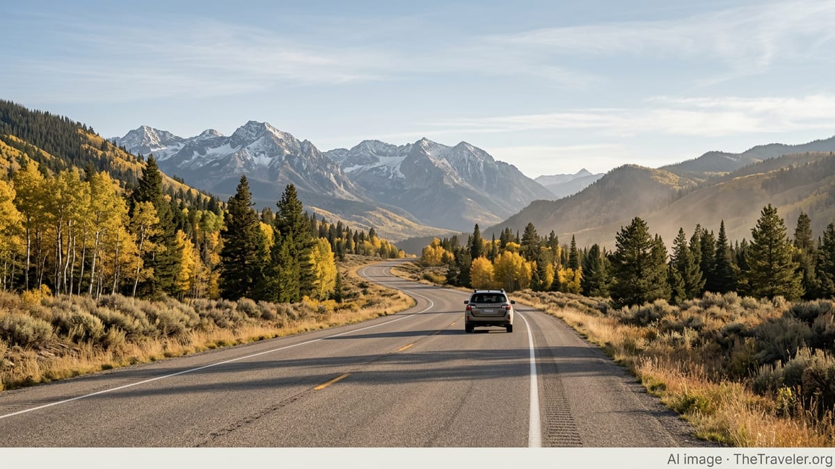
Glancing at a map, Idaho can look compact, especially compared with neighboring states like Montana or Nevada. On the ground, though, travel takes time. Mountains, river canyons and two-lane highways slow average speeds, and there are relatively few interstate shortcuts. The main north–south artery is U.S. 95, which winds through rural communities and mountain passes, while Interstate 84 links the Oregon border to Boise and then the Magic Valley and southeast Idaho. Even on these larger routes, you will often find long stretches between services, so plan fuel and food stops before you set out.
Distances that seem modest on paper often take longer than visitors expect. A trip between major hubs such as Boise and Idaho Falls typically involves a mix of interstate and high-desert driving, while reaching popular recreation areas in the Sawtooth Mountains, Salmon River country or the Idaho Panhandle usually requires leaving the freeway for curvier, slower highways. Add in variable weather, wildlife on the road, and occasional construction or rockfall controls in canyons, and it is wise to build extra time into every leg of your itinerary.
Drivers accustomed to dense service stations may be surprised by gaps between fuel stops and limited late-night options. In rural areas, some gas stations still keep traditional business hours, especially in winter, and credit card readers at unattended pumps are not universal. Before you leave a larger town, top up your tank, carry drinking water and snacks, and keep a paper map or saved offline mapping data in case of spotty mobile coverage, which is common in canyons and high country.
The reward for this slower pace is that the drive is part of the trip. Idaho’s scenic byways trace the Salmon, Clearwater and Snake rivers, cross high plateaus and pass trailheads, hot springs and historic sites. Planning realistic daily driving distances allows time to pull over safely for viewpoints, short walks and unexpected roadside stops without feeling rushed or tempted to push too hard when light or weather changes.
Navigating Mountain Passes and Seasonal Road Conditions
Idaho’s character is defined by its mountains, and many popular routes involve crossing passes where conditions can change with little warning. Even in late spring or early fall, travelers can encounter wet snow, slush, fog or sudden temperature drops over higher summits, while lower valleys stay mild. In winter, the Idaho Transportation Department and Idaho State Police regularly remind drivers that slowing down, increasing following distance and checking conditions before departure are essential habits on major passes.
Key corridors such as Lookout Pass on the Montana border, White Bird Pass in north-central Idaho, Fourth of July Pass in the Panhandle and high routes leading toward the Tetons and Yellowstone can all see rapidly deteriorating conditions when storms move through. Agencies stress that you should adjust speed well below posted limits in poor weather, avoid using cruise control on icy roads and remember that bridges and overpasses tend to freeze first. Plows operate across the state each winter, but they cannot eliminate black ice or low visibility, so a flexible schedule and a willingness to wait out storms are important safety tools.
Even in summer, mountain driving in Idaho requires patience and attention. Steep grades, sharp curves and narrow shoulders are common, and slower vehicles including RVs and logging trucks may dictate the pace. Use turnouts to let faster traffic pass and resist the urge to cut corners on blind bends. On long downhill sections, shift to lower gears to avoid overheating brakes rather than relying solely on constant braking. These habits are particularly important on two-lane highways where passing opportunities are limited and where rockfall or wildlife in the roadway can create sudden hazards.
Because conditions vary so widely by elevation and region, checking a trusted road information source close to departure is more reliable than relying on a forecast from several days earlier. Winter and shoulder-season travelers should be prepared for temporary closures or chain requirements over certain passes and understand that advisory messages may be updated throughout the day. Build contingency time into your itinerary, especially if you must cross multiple passes or if your route includes remote stretches with limited services.
Weather Changes Across Idaho’s Regions
Idaho spans several climate zones, from relatively mild valleys to subalpine basins and heavily forested mountains. That variety is a major draw for travelers, but it also means you can encounter three seasons in a single day as you move between regions and climb in elevation. Typically, lower-elevation cities such as Boise or Lewiston experience hot, dry summers and comparatively moderate winters, while central mountains and the Panhandle receive deeper winter snow, cooler summers and more frequent storms.
Elevation is the biggest factor. For every climb into higher terrain, temperatures generally drop and the likelihood of precipitation increases. A sunny, 80-degree afternoon in the Snake River Plain can coincide with brisk winds and afternoon thunderstorms over the Sawtooth, Bitterroot or Selkirk ranges. In shoulder seasons like May, June, September and October, this contrast is even sharper, with valley hiking trails already dry while higher routes still hold lingering snowfields or mud. Travelers planning scenic drives into mountain basins or high passes should check whether roads are fully open and consider that even paved routes may experience frost or overnight icing well into spring.
Winter timing also varies. Some regions see persistent snowpack from late fall into early spring, while lower valleys cycle through episodes of snow, rain and freeze-thaw that can leave roads slick even when they look clear. Freezing rain and dense fog are periodic hazards in river valleys, where inversions trap cold air and exhaust, reducing visibility and air quality. In contrast, clear, cold days in the mountains can be bright and inviting but still present avalanche concerns in steep backcountry terrain well away from plowed roads and groomed ski areas.
Summer visitors often underestimate day-to-night temperature swings, particularly in arid valleys and high basins. It is common for warm afternoons to cool quickly after sunset, especially near rivers and lakes. Afternoon thunderstorms can build rapidly on hot days in July and August, bringing lightning, brief downpours and gusty winds that affect hikers, boaters and campers. Planning clothing and gear for both strong sun and chilly evenings will keep you comfortable whether you are strolling through Boise’s Greenbelt or camping beside a remote alpine lake.
Sharing the Landscape With Idaho’s Wildlife
Idaho’s wild reputation is not just marketing. The state supports healthy populations of large mammals and predators, including elk, deer, pronghorn, moose, black bears and, in some regions, grizzly bears and wolves. State wildlife agencies emphasize that encounters are possible not only in backcountry settings but also along roads, trails and even in the outskirts of towns, particularly where forests meet neighborhoods and where corridors connect mountain ranges. Travelers can enjoy the chance to see wildlife while also reducing risk to themselves and the animals.
Current guidance from Idaho tourism and conservation organizations highlights the importance of distance. Experts often recommend staying at least tens of meters away from large herbivores such as deer, elk and moose and significantly farther from predators including bears, wolves and mountain lions. Binoculars and telephoto lenses allow for close viewing without approaching. Never attempt to feed wildlife or lure them closer for a photograph. Animals that become habituated to people and food sources are more likely to be involved in conflicts and may ultimately have to be relocated or removed.
In bear country, the emphasis is on prevention. Conservation groups and wildlife agencies in Idaho advise travelers to store food, garbage and scented items securely when camping or picnicking, use bear-resistant containers where available, and maintain clean campsites. Hikers are encouraged to make noise on the trail in dense vegetation or near running water so bears are not surprised at close range, to travel in groups when possible and to carry bear spray and know how to use it. Similar principles apply around mountain lions: keeping children close, avoiding trail running at dawn or dusk in high-use wildlife corridors, and backing away slowly if you encounter a cat rather than turning and running.
Smaller but still significant hazards include rattlesnakes in dry, rocky environments and ticks and mosquitoes in brushy or wet areas, especially in late spring and early summer. Staying on established trails, watching where you place your hands and feet, and wearing long pants and insect protection in tick-prone areas all lower your risk. If you are traveling with dogs, keep them leashed in areas where they could disturb wildlife or encounter snakes, and be aware of local rules regarding pets on trails and in campgrounds.
Roadside Wildlife and Safe Driving Practices
Many travelers’ closest wildlife encounters in Idaho happen from behind the wheel. Elk, deer and moose frequently cross highways, especially at dawn and dusk, and smaller animals like foxes and coyotes are often active at night. Some corridors in the Idaho Panhandle and other regions are known pathways for animals moving between mountain ranges, which is one reason you may see signs warning of increased wildlife crossing activity. Paying attention to these warnings, especially in low light or poor weather, is a key safety measure.
To reduce collision risk, slow down in signed corridors and scan the shoulders and ditches as you drive, particularly where vegetation grows close to the road. Remember that animals often travel in groups: if one deer has crossed, others may be about to follow. Use high beams when safe and legal to do so, dimming for oncoming traffic, and avoid the temptation to swerve sharply if an animal appears suddenly. In general it is safer to brake firmly in a straight line than to jerk the wheel and risk losing control, especially on slick or gravel surfaces.
At night and in winter, the combination of ice, snow or fog and wildlife requires extra care. Reflections from animal eyes may be one of the first signs of movement ahead, but blowing snow can obscure them. In rural stretches, be prepared for livestock as well, particularly in open-range areas where cattle graze near or even on the roadway. If you do hit an animal or come upon a collision, move your vehicle safely out of traffic if possible, turn on hazard lights and contact local law enforcement for guidance rather than approaching a large injured animal yourself.
Drivers pulling trailers or driving RVs should be particularly cautious about braking distances and stability when an unexpected obstacle appears. Slower speeds, greater following distances and gentle steering inputs give you more time to react and reduce the likelihood of a secondary incident. Planning to avoid driving at peak wildlife movement times whenever feasible, especially in heavily forested or riparian areas, further reduces the chances of close calls.
Packing Smart for Idaho’s Varied Climates
Packing for Idaho is less about formality and more about versatility. Even if your itinerary focuses on one region, you are likely to encounter different temperatures, sun exposure and precipitation types during your trip. Layers are your best friend. A base layer that wicks moisture, a light insulating layer such as a fleece or light puffy, and a wind and water-resistant outer layer can be combined or shed easily as conditions change. This system works for shoulder-season city strolls as well as for high-country day hikes.
Footwear deserves particular attention. In towns and on short, paved walks, comfortable walking shoes or sneakers are usually sufficient, but for dirt trails, rocky viewpoints and wet or snowy conditions, sturdy shoes or boots with good traction provide far more security. Winter and early-spring visitors should consider waterproof footwear and warm socks, while summer travelers will appreciate breathable shoes that still offer protection from rocks, cactus spines and the occasional muddy patch. Flip-flops are best reserved for hot springs or campground showers rather than trail use.
Regardless of season, sun protection is essential. Much of Idaho sits at higher elevation than coastal regions, and UV exposure can be significant, especially around reflective surfaces like snow, water and light-colored rock. A brimmed hat, sunglasses with good UV protection and broad-spectrum sunscreen will keep you more comfortable on long driving days and outdoor excursions. Refillable water bottles or hydration bladders help you stay ahead of dehydration in the dry climate, and a small daypack makes it easy to carry layers, snacks and safety items on walks or short hikes away from the car.
Travelers heading into more remote areas should go a step beyond everyday packing and assemble a simple safety kit. Items might include a paper map, compact first-aid supplies, a flashlight or headlamp, a basic tool or multi-tool, emergency snacks, and in colder seasons, a blanket or extra warm clothing stored in the vehicle. For winter road trips, consider adding an ice scraper, small shovel, traction aids, and extra windshield washer fluid suitable for freezing temperatures. None of these items take up much space, but they can make an unexpected delay or change in conditions far less stressful.
Seasonal Strategies for a Safer Idaho Adventure
Each season in Idaho has its character, and tailoring your plans to the calendar can improve both safety and enjoyment. Winter rewards prepared travelers with quiet trails, snow-covered peaks and lively ski towns, but also brings the most demanding driving. Authorities often emphasize carrying appropriate tires, reducing speed on snow and ice, and watching for plows. If your plans are flexible, consider scheduling long drives during daylight hours, when ice patches and hazards are easier to see and when help is more readily available if needed.
Spring and fall are shoulder seasons that appeal to many visitors seeking fewer crowds and milder temperatures. These periods can be among the most unpredictable for weather, with rapid swings between warm sun and late-season snow or hard frosts. Roads may alternate between clear pavement, wet surfaces and occasional slush within a single day, particularly near passes and higher valleys. Hiking trails can be muddy or partially snow-covered, and some high-country roads, campgrounds and services may open later than expected or close earlier depending on conditions. Building backup hikes and drives at lower elevations into your plans helps you pivot without losing a day.
Summer is the most straightforward season for road access, but it has its own considerations. High temperatures in some valleys, especially in southern Idaho, can make midafternoon hikes uncomfortable, so early starts are wise. Thunderstorms may develop quickly on hot days, affecting exposed ridges, lakes and river trips. By late summer, wildfire smoke is a periodic factor across the interior West, including Idaho; checking air quality and fire information when planning outdoor activities can help you choose destinations and exertion levels that are comfortable for you. Wherever and whenever you travel, staying attuned to local advisories from land managers and tourism offices will keep you aligned with current conditions.
Across all seasons, flexibility is perhaps the most valuable thing you can pack. Idaho rewards those who can shift a hike to a lower trail when snow lingers, postpone a long mountain drive when a cold front moves in, or swap a stormy lake day for a museum visit and hot springs soak. Building that adaptability into your mindset before you arrive turns weather and road surprises into manageable variations rather than trip-ending frustrations.
Frequently Asked Questions (FAQ)
Q1. How long does it really take to drive across Idaho?
Drive times vary with your route, but due to mountains, two-lane highways and slower scenic sections, it often takes longer than map distances suggest. For planning purposes, assume lower average speeds than on flat interstates and build generous breaks into each day.
Q2. Do I need special tires or chains to drive in Idaho in winter?
Many travelers manage with good winter or all-weather tires, but conditions can be severe on mountain passes. Chain requirements may be announced during storms, particularly on higher routes. Check current advisories close to departure and consider carrying chains if you expect to cross significant passes.
Q3. How quickly can the weather change between Idaho’s valleys and mountains?
Weather can shift over the course of a single drive. It is common to leave a dry, mild valley and encounter colder temperatures, wind, fog or snow over nearby passes within a few hours, especially in shoulder seasons and winter.
Q4. Is it safe to stop and take photos of wildlife from the roadside?
It can be, if you stay in a safe pullout, remain inside or very near your vehicle, and give animals plenty of space. Never stop suddenly in the travel lane, do not approach animals on foot, and leave if your presence seems to change their behavior.
Q5. Are there rattlesnakes on popular hiking trails in Idaho?
Rattlesnakes are present in many drier, lower-elevation areas, including some popular trails. Staying on marked paths, watching where you step and avoiding placing hands on unseen ledges or into rock piles greatly reduces risk.
Q6. What should I pack for a summer road trip through Idaho?
Plan on light, breathable clothing for hot days plus a warm layer for cool evenings, along with sturdy walking shoes, sun protection, refillable water bottles and a basic car safety kit. Nights in higher elevations can still feel chilly, even in midsummer.
Q7. How can I prepare for wildlife encounters while camping?
Store food and scented items securely, keep a clean campsite, and follow local guidance on bear-resistant containers. Making noise when moving around at night, keeping pets leashed and carrying bear spray in known bear country further reduces risk.
Q8. Is cell service reliable in Idaho’s backcountry and mountain areas?
Coverage is good along many interstates and near larger towns, but it can be limited or absent in remote valleys, canyons and high-country roads. Download maps for offline use, carry a paper map as backup and let someone know your planned route and timing.
Q9. What is the best time of year to avoid hazardous driving conditions?
Summer generally offers the most predictable driving, with clear roads over most passes. However, thunderstorms, construction and occasional wildfire smoke can still affect travel, so it remains important to check conditions shortly before driving.
Q10. How much extra time should I add to my schedule for Idaho’s roads?
It depends on distance and season, but many travelers find that adding 25 to 50 percent more time than a basic map estimate allows for fuel stops, weather, slower traffic and scenic pauses. Building a comfortable margin helps keep your trip relaxed and safe.