
More news on this day
Heavy rain, thunderstorms and localized flooding risks are being flagged for later this week, as the India Meteorological Department (IMD) highlights a strong wet spell expected to peak on the 27th and 28th across several regions.
Get the latest news straight to your inbox!
Stronger Wet Spell Building Ahead of 27th and 28th
Recent national and regional bulletins from the India Meteorological Department indicate that a fresh spell of intense weather is likely to organize over parts of northern, eastern and northeastern India in the coming days, with model guidance clustering around the 27th and 28th for the heaviest rain. The pattern follows a month of highly changeable conditions, from heat over western India to frequent thunderstorms over the Indo-Gangetic plains.
Publicly available outlooks suggest that a combination of western disturbances moving in from the northwest and moisture transport from the Bay of Bengal could overlap late in the month, increasing the odds of widespread moderate to heavy rainfall. While exact rainfall totals will vary by district, several states are being highlighted for potential downpours, including sections of the western Himalayan region, the eastern plains and parts of the northeast.
Earlier seasonal guidance from IMD and other agencies has already underlined an active pre-monsoon period, with frequent convective storms over central and eastern India. The anticipated 27–28 window is being viewed as part of this broader active phase, rather than an isolated event, raising concerns about saturated soils and a quicker onset of waterlogging in urban areas.
Meteorological analyses point to sharp temperature contrasts between hot air over the plains and cooler air aloft associated with passing disturbances. This contrast tends to fuel strong updrafts, setting the stage for thunderstorms that can produce intense short-duration rain, gusty winds and, in some pockets, hail.
Regions Most Likely to Be Affected
According to recent forecast charts and narrative discussions, the highest rain probabilities around the 27th and 28th focus on the western Himalayan states, adjoining plains in north India, and a belt stretching toward Bihar, Jharkhand and West Bengal. Northeastern states are also expected to remain under an unsettled pattern, with some models indicating heavy to very heavy rain, especially in orographically elevated terrain.
In the western Himalayas, a renewed western disturbance is projected to enhance cloudiness and precipitation, leading to spells of moderate to heavy rain and snowfall at higher altitudes. This could affect travel across mountain passes and increase the likelihood of landslides in vulnerable slopes where snowmelt and earlier showers have already loosened soil.
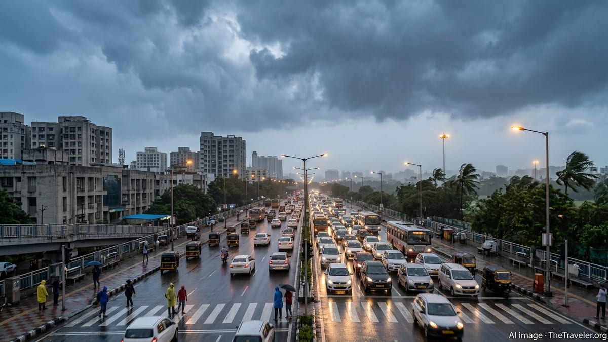
For the northern plains, including parts of Punjab, Haryana, Delhi and western Uttar Pradesh, a mix of scattered thunderstorms and organized rain bands is likely. These systems often form during late afternoon and evening, bringing sudden downpours that can overwhelm drainage in dense urban corridors and trigger localized flash flooding.
Farther east, convergence of moist winds from the Bay of Bengal with cooler air from the northwest may support long-lasting rain over sections of Bihar, Jharkhand, West Bengal and the northeast. Hill districts in states such as Meghalaya, Nagaland, Manipur and Tripura are particularly prone to heavy orographic rainfall, which can quickly raise river and stream levels.
Potential Travel and Infrastructure Disruptions
For travelers and local commuters, the timing of the heaviest rain around the 27th and 28th aligns with busy work and school days, heightening the risk of disruption. Past heavy-rain episodes in India have frequently caused delays to flights, regional rail services and long-distance buses, as low visibility, waterlogged tracks and blocked roads compound the impact of intense showers.
In major cities, short but intense cloudbursts can flood key junctions, underpasses and airport approach roads within minutes. Drainage systems clogged by debris or ongoing construction are particularly vulnerable, leading to traffic jams and longer travel times even after rain intensity begins to ease.
Hill and foothill regions face a different set of concerns. Continuous or repeated heavy rain over steep terrain can trigger landslides that block highways and rural roads, isolate communities and disrupt tourism flows to popular hill stations. Riverfront and low-lying resorts, homestays and campsites may also need to watch for rapid rises in water levels, especially where catchments are already wet.
Power supply can be impacted as well, as strong winds and lightning associated with thunderstorms occasionally damage overhead lines or substations. Travelers relying on electronic ticketing, navigation and digital payments may find it helpful to prepare offline backups and keep devices charged where possible.
What the Alerts Mean for Residents and Tourists
IMD uses a color-coded system to communicate changing risk levels to the public, ranging from green outlooks for settled conditions to yellow, orange and red alerts for increasingly severe weather. Heavy rain episodes that can disrupt daily life and travel usually trigger yellow or orange alerts at first, with escalation possible if model guidance converges on very intense rainfall or if impacts begin to materialize on the ground.
For residents, a yellow or orange alert around the 27th and 28th typically signals a need to plan ahead for possible delays rather than panic. This can include allowing extra commuting time, avoiding unnecessary trips during peak storm periods and monitoring local forecasts from regional meteorological centers and reliable news outlets.
Tourists, particularly those on tight itineraries, may face schedule changes if sightseeing, trekking or intercity travel overlaps with the most active phases of the wet spell. Mountain hikes, river rafting and visits to waterfalls or gorges can become dangerous quickly in heavy rain, and operators often suspend activities when alerts are in force.
Accommodation choices also matter during severe weather. Stays in low-lying areas near rivers, lakes or stormwater channels are more vulnerable to flash flooding, while properties on unstable slopes may face increased landslide risk. Checking recent local conditions and favoring lodgings with clear drainage and access to main roads can reduce exposure.
Practical Safety Advice for the 27–28th Wet Spell
Publicly available guidance from disaster management agencies and meteorological services consistently emphasizes avoiding unnecessary exposure during episodes of heavy rain and thunderstorms. Around the 27th and 28th, residents and visitors in affected regions may want to organize errands, travel and outdoor activities for the morning hours, when convective storms are generally less intense, while remaining flexible as local forecasts are updated.
Motorists are advised in many advisories to avoid driving through waterlogged stretches where road depth is uncertain. Even shallow moving water can destabilize smaller vehicles, while hidden potholes and open manholes are a recurring hazard during urban flooding. Those using two-wheelers are particularly vulnerable in such conditions.
Basic household precautions can also make a difference. Securing loose outdoor items, clearing roof drains and balconies, checking backup power arrangements and storing essential documents and electronics away from floor level all help minimize damage if water enters homes. Residents in buildings with basements or underground parking may need to be alert to rapid water accumulation.
For travelers, monitoring airline, railway and bus operator advisories in parallel with weather updates is important, as transport providers may adjust schedules or temporarily suspend services for safety reasons. Keeping identification, critical medications and a small emergency kit accessible can ease unexpected delays. As the 27th and 28th approach, forecasters are expected to refine district-level projections, so those in potentially affected areas are encouraged to follow the latest bulletins rather than relying on older forecasts.