
Iowa rewards travelers who are willing to slow down. Beyond the interstate, a network of scenic byways threads through limestone bluffs, ancient river valleys, quirky small towns, and a surprisingly varied lineup of state parks. A road trip here is less about racing between big-name sights and more about drifting along back roads, lingering over pie in a family cafe, and waking up to birdsong in a forested campground. This itinerary-style guide outlines how to link Iowa’s most compelling small towns, scenic drives, and parks into a three to seven day journey that feels unhurried yet full.
How Long To Spend On An Iowa Road Trip
The ideal length for an Iowa road trip that focuses on small towns, scenic byways, and state parks is between three and seven days. In three days, you can sample one region in depth, such as the Driftless northeast or the Loess Hills in the southwest. With a full week, you can comfortably connect two or three of the state’s most scenic corridors without feeling rushed.
Driving distances are manageable, but secondary roads and byways are slower than the interstate. Many of Iowa’s most beautiful routes, including the Driftless Area Scenic Byway in the northeast and the Loess Hills National Scenic Byway along the western border, wind through hilly terrain with frequent curves and overlooks, which naturally slows your pace. Planning on two to four hours of actual driving per day leaves room for hiking, museum stops, and unplanned detours.
Accommodation options range from basic state park campgrounds to historic inns in towns like Decorah, McGregor, Winterset, and Pella. Summer and early fall are the busiest periods, especially around festival dates and school holidays, so advance reservations are recommended if you want specific campgrounds or popular small town lodgings. Outside those peaks, it is usually possible to keep plans flexible and book only a day or two ahead.
Weather matters in Iowa more than many visitors realize. Summer brings lush green fields and long evenings, but also humidity and the possibility of thunderstorms. Early fall is a sweet spot, with colorful foliage along the Mississippi River bluffs and Loess Hills, cooler hiking temperatures, and generally stable conditions. Spring wildflowers and migrating birds are a bonus in April and May, though some trails can be muddy.
Northeast Iowa: Driftless Bluffs, Decorah, And River Towns
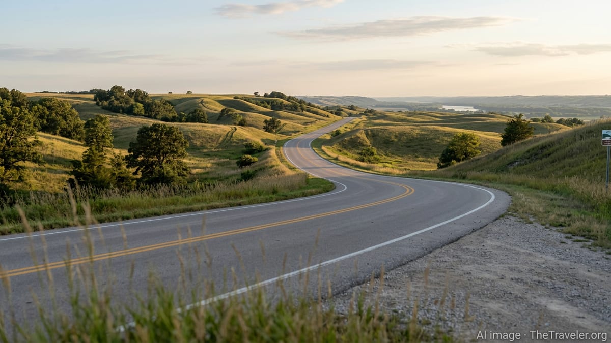
Northeast Iowa is where many travelers first realize how varied the state’s landscapes can be. The Driftless Area Scenic Byway loops through Allamakee and Winneshiek counties, a pocket of land bypassed by the last glaciers. Instead of flat prairie, you will find steep forested ridges, deep valleys, and rivers that carve tight meanders through limestone. The byway itself covers roughly 140 miles and is frequently described as one of the most scenic drives in the state, with constant views of bluffs, farms perched on high ridgelines, and winding stretches of the Upper Iowa and Yellow rivers.
Decorah makes an excellent base for this section of an Iowa road trip. The town blends a walkable historic downtown with easy access to outdoor activities. Travelers often pair strolls past brick storefronts and local breweries with side trips to Dunning’s Spring, Palisades Park, or the trout streams and river put-ins that dot the area. Decorah’s location near the byway means you can either loop out in a day and return to the same lodging, or move gradually from town to town as you follow the route.
Further east, river towns such as McGregor and Marquette sit tucked against limestone bluffs along the Mississippi. Just south of here, Pikes Peak State Park provides one of Iowa’s classic viewpoints, with a broad overlook above the confluence of the Mississippi and Wisconsin rivers and a network of forest trails around waterfalls and rock outcrops. Many itineraries slot Pikes Peak as either a day stop from Decorah or as a one-night pause before heading south along the Great River Road.
If you have an extra day in the northeast, consider folding in Effigy Mounds National Monument near Harpers Ferry or Yellow River State Forest. Both offer more remote hiking and, in the case of the mounds, significant Indigenous cultural history, which deepens the sense that this pocket of Iowa has long been a landscape people traveled to, not just through.
Central Iowa: Canyons, Farmland Views, And Ledges State Park
Central Iowa is often associated with wide fields and the state capital of Des Moines, but it also hides some surprisingly rugged corners. Ledges State Park, just south of Boone, is one of the state’s earliest parks and remains a favorite for in-state road trippers. Here, a narrow sandstone gorge carved by Pea’s Creek and the Des Moines River creates 50 foot rock walls and shaded canyon roads that feel a world away from the nearby cornfields. A winding one lane drive crosses the creek several times, and short trails lead to overlooks above the bluffs and down into cool, mossy side ravines.
Ledges works well as a half day to full day stop in a longer itinerary, particularly if you are connecting the northeast region with the covered bridge country of Madison County. Many travelers pair a morning hike among the sandstone formations with an afternoon drive through Boone County and across the Des Moines River valley, timing their visit for late afternoon light over the rolling farmland.
Nearby towns such as Boone and Madrid offer a practical mix of motels, local diners, and small museums. For a more urban interlude, Des Moines is within reasonable driving distance and can anchor a night or two on either side of your nature-focused days. The city’s restaurants, art venues, and botanical garden can provide a welcome contrast to campground meals and back road cafes.
Backbone State Park, located northeast of central Iowa near Strawberry Point, is another worthwhile addition if your route bends that way. Often called Iowa’s oldest state park, it is named for a narrow limestone ridge known as the Devil’s Backbone, carved by a loop of the Maquoketa River. Trails follow the top of the ridge and drop down into forested valleys, while the lake and picnic areas offer quieter spots to pause mid road trip.
Eastern Iowa: Maquoketa Caves, Bellevue, And The Great River Road
Eastern Iowa offers a different flavor of scenery, with karst landscapes, caves, and dramatic river views. Maquoketa Caves State Park in Jackson County is one of the state’s most distinctive parks, where a network of trails links sinkholes, natural bridges, and caves of varying sizes. Some passages are tall enough to walk through comfortably, while others require stooping or crawling and are best for those comfortable with tight spaces. The main loop combines boardwalks, stone steps, and forest paths, so visitors can choose how adventurous they want the experience to be.
Because the caves are a sensitive environment, portions of the park can be subject to seasonal closures or restrictions, often related to bat habitat protection or safety conditions. It is wise to check recent updates from park authorities before planning a long detour. When open, the caves can be busy on summer weekends, so early morning or late afternoon visits provide a quieter atmosphere and cooler temperatures.
From Maquoketa, a natural next step is to drive east to the Mississippi River and link up with the Great River Road National Scenic Byway. This long route tracks the Mississippi through multiple states, and the Iowa portion passes river towns, wildlife areas, and overlooks. Bellevue State Park, perched just south of the town of Bellevue, offers classic river views, short trails past Native American burial mounds, and a restored prairie with a butterfly garden. It works well as a picnic and hiking stop between longer driving legs.
Continuing north or south along the Great River Road, travelers can string together stops in communities that still feel closely tied to the river, from fishing access points and small marinas to Main Streets that look much as they did a century ago. The pace along this corridor is naturally slow, both because of the curving roads and the temptation to pull over at every new bluff top overlook.
Western Iowa: Loess Hills, Waubonsie, And The Open Road
Western Iowa has a distinct landscape shaped by windblown silt that piled into long ridges known as loess. The Loess Hills National Scenic Byway parallels the Missouri River in the western part of the state, weaving among rolling hills with steep, narrow slopes unlike anything else in the Midwest. The byway combines mainline routes with spurs that climb to overlooks and drop into quiet valleys. It is especially striking in late afternoon or early evening, when low sun angles emphasize the contours of the hills.
Waubonsie State Park, in Fremont County near the southern reach of the Loess Hills, is a standout stop. Overlooks from the ridges provide wide views across both the hills and the Missouri River valley, while trails traverse forests, prairies, and sheltered hollows. The geology is a central part of the park’s story, with signage explaining how fine silt carried by ancient winds accumulated into the sharply sculpted hills seen today.
Small towns along or near the Loess Hills Byway tend to be quiet and low key, with a mix of grain elevators, historic main streets, and single cafes that also serve as informal community hubs. Many travelers treat this region as a scenic alternative to the interstate when driving between Omaha and Sioux City or Des Moines and the Dakotas. Given how empty some stretches can feel, it is sensible to top up fuel when you have the chance and carry water and snacks between towns.
Camping in this region can be especially atmospheric on clear nights, with broad sky views for stargazing and relatively little light pollution away from larger centers. Spring and fall are particularly pleasant, as summer heat and humidity can be more noticeable in the exposed prairies and open hillsides.
Covered Bridges, Storybook Towns, And Central Byways
Southwest of Des Moines, the Covered Bridges Scenic Byway in Madison County threads past some of Iowa’s most photographed structures. The timber bridges scattered across the countryside inspired the novel and film set here, and today they anchor a driving loop that mixes nostalgia with rolling farmland vistas. The county seat of Winterset serves as both a practical base and a destination in its own right, with a restored courthouse square, local museums, and a connection to the birthplace of actor John Wayne.
Pammel State Park, near Winterset, adds outdoor variety to a covered bridge themed day. As one of Iowa’s earlier state parks, it features mature forests, river access along the Middle River, and a road that famously passes through a low water tunnel carved through rock. Visitors often combine a picnic and short hike at Pammel with time spent photographing bridges in the softer light of morning or evening.
For travelers who enjoy small town architecture and cultural heritage, Pella offers a different but complementary atmosphere. Known for its Dutch roots, the town is dotted with brick storefronts, windmill structures, and bakeries selling European style pastries. In spring, tulips fill public gardens and line sidewalks during a long running festival period, while the rest of the year the town remains a pleasant stop for walking, coffee, and local history exhibits.
Linking Winterset and Pella can be part of an unofficial central Iowa loop that touches multiple scenic routes, including the Iowa Valley Scenic Byway to the east. That corridor follows the Iowa River through rolling farm country, passing the Amana Colonies and other historic communities. Drivers who enjoy layering history, food stops, and light hiking will find that these central routes knit together smoothly into a two or three day circuit.
Planning Your Route, Seasons, And Practical Tips
Because Iowa’s scenic highlights are spread across the state, road trippers have several choices in how to structure an itinerary. One common approach is to focus on a single region, such as the northeast Driftless Area or the western Loess Hills, and build a three or four day loop around it. This suits travelers who want to spend more time hiking, paddling, or browsing small town shops and less time in the car. Another strategy for those with a week is to create a broad arc, starting in one corner of the state and finishing in another while linking two or three major byways.
Seasonality is central to planning. Summer offers the fullest set of options, with all parks open, festivals in many towns, and long daylight hours that stretch well into the evening. However, temperatures and humidity can be high, and thunderstorms are more common. Spring brings budding trees and wildflowers, especially in wooded parks such as Ledges, Backbone, and Yellow River State Forest, but some trails may be wet or partially closed after heavy rain. Autumn is prized by many in-state travelers, with harvest colors, cooler days, and especially vivid views along the Mississippi bluffs and Loess Hills ridgelines.
Regardless of season, pack with flexibility in mind. Footwear that can handle mud, gravel, and slick rock will make cave and gorge hikes more comfortable. Lightweight layers are important in a state where a sunny afternoon can turn cool quickly once clouds move in. In summer, insect repellent is handy around rivers, forests, and prairies. A small headlamp or flashlight is essential for exploring darker sections of Maquoketa Caves or early morning walks around campgrounds.
Finally, remember that much of the appeal of an Iowa road trip lies in unplanned moments. Antique shops that appear in the middle of nowhere, farm stands at the end of gravel lanes, and unexpected overlooks along a byway all invite lingering. Leaving some gaps in the schedule will let you pull over for an extra photo stop, add an impromptu detour to a county park, or simply sit on a small town bench and watch daily life unfold.
The Takeaway
Driving across Iowa on the interstate gives only a thin impression of the state. Drop down onto its scenic byways and you discover a different place entirely, shaped by ancient river systems, windblown hills, and communities that have grown up alongside them. Small towns like Decorah, McGregor, Winterset, and Pella offer walkable centers, distinct local character, and access to surrounding landscapes that reward slow exploration.
State parks such as Ledges, Maquoketa Caves, Backbone, Waubonsie, and Pikes Peak add depth to any itinerary, turning a simple drive into a series of immersive stops. Short trails, river overlooks, and shaded picnic spots make it easy to break long stretches behind the wheel into manageable segments. For travelers willing to camp, many of these parks can become overnight homes, with night skies and morning bird calls replacing hotel corridors.
Whether you dedicate a long weekend to one corner of Iowa or a full week to a multi region loop, you will likely leave with a different sense of the Midwest than the one you arrived with. This is a landscape of subtle drama rather than spectacle, where the best memories often come from sitting quietly on a bluff at dusk or following an unmarked gravel road just to see where it goes.
Plan your route, respect the weather, and leave room for spontaneity. Iowa’s small towns, scenic byways, and state parks will do the rest.
FAQ
Q1. How many days do I need for an Iowa road trip focused on byways and state parks?
Most travelers find that three to seven days works well. Three days is enough for one region, while a week lets you comfortably combine two or three scenic byways without rushing.
Q2. When is the best time of year to drive Iowa’s scenic byways?
Late spring through early fall is ideal. Summer has the longest days and most open attractions, while early fall adds cooler temperatures and colorful foliage along bluffs and hills.
Q3. Are Iowa’s state parks suitable for first time hikers?
Yes. Parks such as Ledges, Pikes Peak, Backbone, and Bellevue have short, clearly marked trails and overlooks. More challenging routes exist, but beginners can easily choose gentler options.
Q4. Do I need a four wheel drive vehicle for this itinerary?
No. The main scenic byways and park access roads are paved or well maintained gravel. Standard passenger cars are fine in normal conditions, though heavy rain or snow can temporarily affect some smaller roads.
Q5. Can I visit Maquoketa Caves and still enjoy the park if I am not comfortable in tight spaces?
Yes. Several larger caves and natural bridges can be appreciated from trails and boardwalks without squeezing into narrow passages, and the forest setting alone makes the park worthwhile.
Q6. Is camping necessary, or can I base in small towns each night?
You can do either. Many visitors combine nights in small town inns or motels with occasional stays in state park campgrounds. Larger hubs like Decorah, Dubuque, and Winterset work well as bases.
Q7. Are reservations required for Iowa state park campgrounds?
Reservations are strongly recommended during summer weekends, holidays, and peak fall foliage periods. Outside those times, some campgrounds may still have first come, first served sites, but availability can vary.
Q8. How much driving should I plan per day on an Iowa road trip?
Planning two to four hours of actual driving per day is comfortable for most travelers. Scenic byways are slower than interstates and invite frequent photo and hiking stops.
Q9. Are there good food options in smaller Iowa towns along these routes?
Yes. While choices are fewer than in cities, many small towns have locally owned cafes, bakeries, or diners. Part of the fun is discovering a favorite pie, pastry, or daily special along the way.
Q10. Is Iowa a good destination for families on a road trip?
It can be excellent for families that enjoy the outdoors and slower travel. Short hikes, caves, easy river views, and low key towns keep drives manageable, and many state parks have playgrounds and kid friendly facilities.