
More news on this day
Once a sleepy strip of sand and canals just beyond Rome’s airports, Isola Sacra is now at the center of one of Italy’s most controversial coastal transformations, raising urgent questions for travelers planning a seaside stop here in 2026.
Get the latest news straight to your inbox!
A Tiny Island at the Mouth of the Tiber under Big Pressure
Isola Sacra, part of the Fiumicino municipality just west of Rome, has long been a low-key alternative to the capital’s crowds, known for informal beaches, seafood restaurants and its Roman archaeological sites between Ostia Antica and the modern airport. Publicly available geographic and historical information shows that this is an artificial island formed between branches of the Tiber River, bordered by unstable shoreline and low-lying land close to sea level.
In recent years, this coastal setting has turned from quiet backwater to strategic waterfront. Regional and national planning documents highlight the area’s vulnerability to flooding and subsidence, prompting hydrogeological risk mitigation projects and renewed attention to how the Tiber’s shifting course and the Tyrrhenian Sea interact along this exposed stretch of coast.
For visitors, the combination of low elevation, changing currents and more frequent winter storms in the central Mediterranean is no longer an abstract climate story. It is starting to shape which beaches are accessible, when seafront areas are deemed safe, and how easy it is to move between Rome, Fiumicino and the island’s shoreline on a short stay.
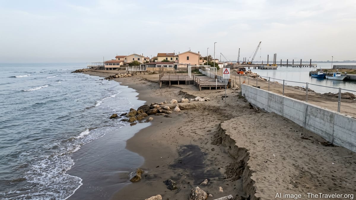
New Fiumicino Cruise Port: Concrete, Construction and a Changing Waterfront
The biggest single shift facing Isola Sacra in 2026 is the large cruise and tourist port planned on its seafront, marketed as the Fiumicino Waterfront project. Company statements and transport-sector coverage describe a multi-berth facility designed to host some of the world’s largest cruise ships, backed by international infrastructure funds and a major cruise line, with the site sitting almost between the beach and Rome’s main international airport.
An Environmental Impact Assessment decree issued in late 2025 confirmed national-level approval of the port concept, with promoters arguing that associated works could help manage erosion and modernize the shoreline. At the same time, Italian and international media have documented strong criticism from environmental groups and neighboring municipalities, with concerns that new breakwaters, dredging and extensive concrete surfaces could disrupt currents at the Tiber’s mouth and accelerate loss of sand along nearby beaches.
Evidence from previous waterfront schemes along the Lazio coast, including earlier proposals in the same area, is frequently cited in this debate. Reports note that older port and defense structures in the region have already contributed to uneven sediment flows, where some stretches of coast gain sand while others see severe retreat. Travelers arriving in Isola Sacra over the next few seasons should expect a visibly altered seafront, active building sites, restricted access around the future piers and a landscape that may look very different from guidebook photos printed only a few years ago.
Coastal Erosion and Storm Damage along Rome’s Shoreline
Broader coastal trends around Rome put Isola Sacra’s makeover in a sharper light. Recent photo coverage of the nearby Ostia shoreline in early 2026 shows storm surges eating into beach clubs, collapsing wooden decks and leaving seafront structures hanging over eroded sand. Regional technical studies on the Lazio coastline report decades of progressive beach loss in multiple municipalities, driven by changing wave patterns, rising sea level and hard infrastructure that interrupts the natural movement of sediment.
Italy-wide assessments by environmental agencies describe coastal erosion as a “noteworthy” and growing problem, with the central Tyrrhenian sector among the hotspots. Scientific literature on Mediterranean coasts links these patterns to a combination of climate change, altered river sediment supply and local construction choices that include harbors, groynes and seawalls. For a low-lying island like Isola Sacra, hemmed in by canals and exposed to both river flooding and marine storm events, the risk profile is complex.
Travelers may notice practical effects in several ways. Some stretches of beach can be significantly narrower than in past seasons or even temporarily closed after severe storms for safety reasons. Temporary barriers and warning signs are more common on eroding stretches, and some long-established beach clubs have reduced usable space. Compared with images from a decade ago, the entire seafront between Ostia, Fiumicino and Isola Sacra appears more fragmented, with alternating armored sections, construction areas and pockets of still-natural dune and scrub.
Flood Risk, Infrastructure Works and Getting Around in 2026
Coastal changes near Isola Sacra are not just about shorelines; they are also reshaping transport and basic services. Local planning coverage outlines ongoing dredging of the Fiumicino port canal and river mouth to maintain safe navigation, works that can temporarily affect small-boat access and create zones off-limits to casual swimming. Parallel projects target hydrogeological safety on Isola Sacra itself, where the combination of subsiding ground and high water tables has prompted investments in drainage and flood defenses.
On land, visitors are likely to encounter intermittent disruption tied to both port construction and broader mobility planning. Public information notes the creation of a “Mobility Committee” that brings together regional and transport players to address the spike in traffic expected when cruise operations intensify. While this is designed to improve long-term connections between the cruise quays, airport and Rome’s rail network, the near term could mean diversions, new one-way systems and heavier construction traffic on already crowded local roads.
Rail users should also be aware that recent years have seen periodic weekend engineering works affecting train services between central Rome and Fiumicino, leading to bus substitutions and longer journey times. Although these disruptions are announced locally and may vary season by season, they underline how infrastructure on the coast is being reconfigured. Travelers planning tight connections between an Isola Sacra hotel, the airport and city-center sightseeing in 2026 should therefore allow extra time, especially during winter and spring when storm damage repairs and rail maintenance works are more frequent.
What 2026 Visitors Should Watch Before Booking
For those weighing a stay on Isola Sacra in 2026, several evolving factors are worth monitoring in the months before departure. First is the construction timetable for the Fiumicino Waterfront cruise port. Industry and media reports indicate that enabling works and ground preparation are already underway, with further phases likely to push heavy construction activity through the mid-2020s. This means noise, restricted shoreline access and changing views, even before the first large vessels are permanently berthed.
The second is the pace of erosion and storm-related closures along adjacent beaches from Ostia to Fiumicino. As recent winter seasons have shown, a single sequence of strong storm surges can transform local beaches in a matter of weeks, affecting everything from where beach clubs can place umbrellas to whether certain seafront promenades remain open. Travelers hoping for relaxed coastal walks or wide sandy stretches immediately outside Rome should be prepared for a more rugged, sometimes damaged landscape than marketing images suggest.
Finally, evolving regional initiatives such as the “Parco del Mare” regeneration project in Ostia signal a broader shift toward softer defenses, expanded dunes and greener waterfronts along parts of the Roman coast. While Isola Sacra’s own future balance between cruise infrastructure and ecological restoration remains contested, visitors in 2026 will be arriving at a shoreline in transition, where rising environmental pressures and ambitious development plans collide at the very point where the Tiber meets the sea.