
More news on this day
A powerful Kona low storm system is unleashing what reports describe as Hawaii’s most severe flooding in more than two decades, inundating Oahu’s North Shore, threatening the aging Wahiawa Dam and triggering mass evacuations and flood alerts from Maui and Molokai to Lanai and the Big Island.
Get the latest news straight to your inbox!
North Shore Oahu Reels as Wahiawa Dam Faces Extreme Stress
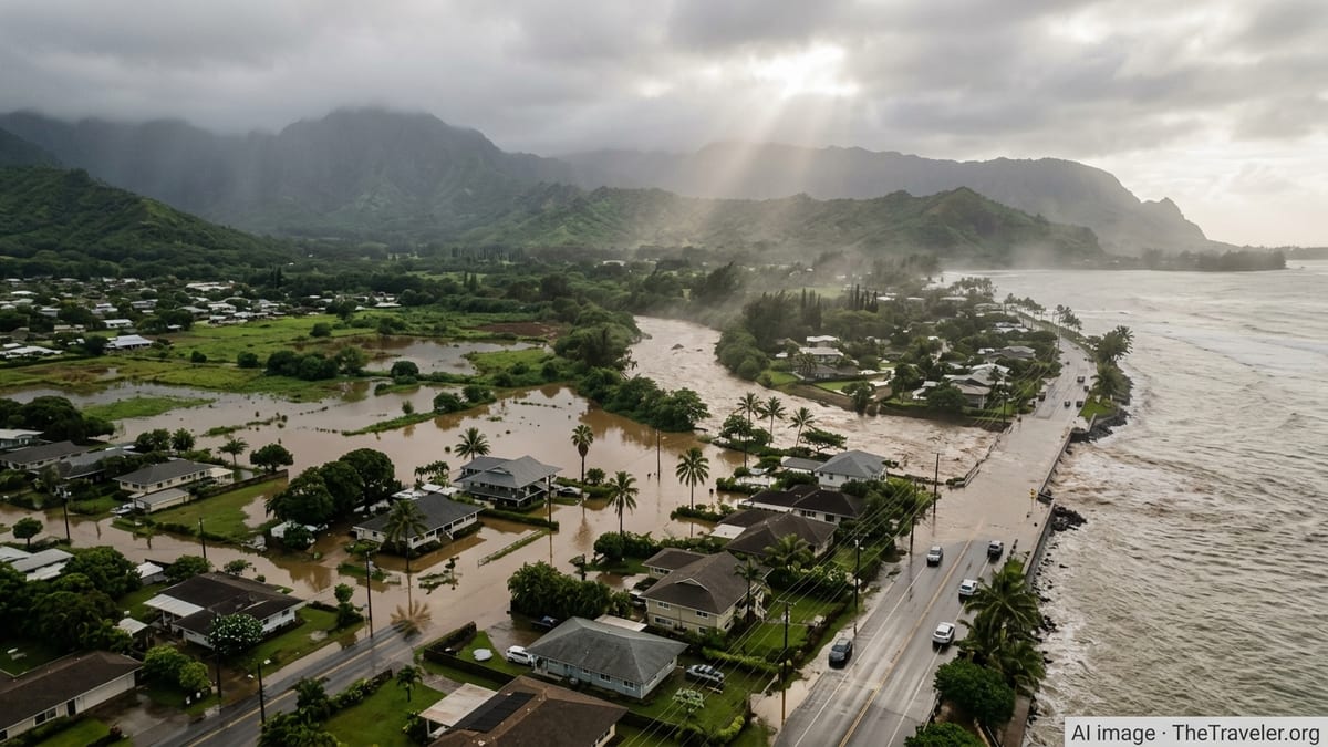
Publicly available information from state and national outlets indicates that intense, moisture-laden bands associated with the Kona low began pounding Oahu late Thursday, March 19, before stalling over the island’s North Shore into Friday and Saturday. Rain gauges and radar estimates show large swaths of the coast north of Honolulu receiving more than 8 to 12 inches of rain in less than 24 hours, with higher totals at upper elevations. The deluge turned rural roads into brown torrents, pushed homes off their foundations and swept vehicles into swollen streams.
On Friday, March 20, local emergency messaging ordered residents downstream of the Wahiawa Dam, also known as Lake Wilson, to evacuate as rapidly rising water levels brought the 120-year-old structure under intense scrutiny. National and local news coverage describes the dam as long identified as vulnerable, with high-hazard classification due to the potential consequences of failure. While the reservoir level later began to recede, alerts remained focused on the possibility that additional heavy rain bands could push the aging infrastructure past safe operating thresholds.
Across the North Shore, from Haleiwa through Waialua and on toward Mokuleia and Kahuku, muddy floodwaters smothered streets, rushed through plantation-era drainage corridors and poured into low-lying homes. Reports indicate that more than 5,000 people were at one point covered by evacuation notices in communities north of Honolulu, and hundreds of rescues have been documented as residents were trapped in inundated houses and vehicles. Shelters opened in schools and community centers, some of which later had to be relocated as floodwaters crept into their own facilities.
Even as skies briefly cleared at times on Saturday, March 21, forecasters warned that the Kona low remained slow moving and that additional heavy bands could pivot across Oahu. Travel advisories urged residents and visitors to avoid unnecessary movement on the North Shore, where sections of the Kamehameha Highway and adjacent rural roads were intermittently closed by deep standing water, debris and undermined pavement.
Maui, Molokai and Lanai Brace for Secondary Flood Impacts
While Oahu has experienced the most acute damage so far, the broader Kona low circulation is also driving hazardous conditions across Maui County. Forecast discussions and local news reports highlight a corridor of persistent heavy rain aimed at the windward and leeward slopes of Haleakala, with retention basins above Lahaina and other vulnerable communities nearing capacity as runoff accelerates down steep watersheds. Evacuation advisories for low-lying sections of West Maui have been upgraded at times to more urgent warnings as rainfall spikes.
Historical analyses from the National Weather Service show that previous Kona low events have produced 11 to 22 inches of rain over eastern Maui in similar multiday setups, underscoring the potential for rapid-onset flash flooding when saturated soils meet renewed downpours. In the current storm, Maui County agencies have been clearing culverts, monitoring stream gauges and pre-positioning resources in districts such as South Maui, Upcountry and the Central Valley, where past events have sent floodwaters through residential neighborhoods and resort zones.
On Molokai and Lanai, the same southerly flow funneling tropical moisture toward Oahu and Maui is enhancing showers and isolated thunderstorms. Earlier Kona low episodes documented by regional media have shown that even three to five inches of concentrated rainfall over a few hours can quickly overwhelm small gulches and dry washes on these smaller islands, where drainage infrastructure is limited and many communities sit close to sea level. Current advisories stress that flash flooding is possible on short notice, particularly near steep terrain and along unlined streambeds.
Travelers moving between Maui, Molokai and Lanai are being warned to anticipate rapidly changing conditions, including localized whiteout rain squalls, ponding on runways and temporary closures of smaller harbors and inter-island ferry routes. Airlines and ferry operators are adjusting schedules around the worst weather windows, with passengers urged through public statements and online notices to monitor status updates closely and build flexibility into their plans.
Big Island Faces Flood Watches, Surf Hazards and Powerful Kona Winds
On Hawaii Island, or the Big Island, the Kona low’s impacts are manifesting in a different but still disruptive mix of hazards. Flood watches and advisories have been issued repeatedly for North and South Kona districts over the past week, as deep tropical moisture wraps around the sprawling circulation and collides with the island’s high volcanic terrain. Radar imagery and ground reports show downpours flaring along the lower slopes of Hualalai and Mauna Loa, at times prompting warnings for communities including Kailua-Kona, Holualoa and Waikoloa.
Past Kona low events documented by the National Weather Service have delivered double-digit multi-day rainfall totals over windward and southeastern portions of the Big Island, leading to widespread stream flooding, rockfall along coastal highways and damage to low-lying infrastructure. In the present storm, county messaging and independent local outlets are emphasizing the risk of fast-rising gulches, landslides on saturated slopes and dangerous conditions at usually calm beach access points as runoff surges seaward.
In addition to inland flooding, coastal impacts are intensifying. Recent coastal flood statements and high surf advisories describe elevated tides and long-period north and west swells combining with storm-enhanced sea levels to produce overtopping and saltwater intrusion along exposed shorelines. Low-lying neighborhoods and resort areas in Kohala and Kona are on alert for water encroaching onto roads and parking lots around high tide, with authorities urging drivers to avoid saltwater-covered pavement where hidden erosion or debris may be present.
Strong southerly and southwesterly winds, characteristic of Kona lows, are also battering the Big Island’s typically sheltered leeward coasts. Gusts over 40 to 50 miles per hour have been reported in some districts, raising concerns about downed trees and power lines. Visitors are being advised to secure outdoor gear, avoid hiking on heavily forested trails during peak wind periods and maintain extra caution when driving near slopes or along coastal routes exposed to crosswinds.
Travel Disruptions and Safety Concerns Across the Islands
As the Kona low lingers, the combined effect of flooding, coastal inundation and high surf is rippling through Hawaii’s tourism infrastructure. Inter-island flights, particularly to and from smaller airfields on Molokai and Lanai, have encountered intermittent delays and cancellations as intense rain bands and low ceilings move overhead. On Oahu and Maui, the temporary closure of key road links has complicated airport transfers and tour operations, leaving visitors and residents alike navigating detours and extended travel times.
Travel industry updates and local news coverage point to multiple closures of popular beaches and coastal parks on the North Shore of Oahu, including areas celebrated for winter surf breaks, due to contaminated floodwaters, debris and hazardous rip currents. Similar closures and advisories are reported on Maui and the Big Island, where brown-water events are working their way offshore and increasing the risk of marine hazards. Public guidance stresses staying out of discolored water, avoiding stream mouths and heeding all posted warnings.
Hotel and resort operators across Oahu, Maui and the Big Island are activating severe-weather protocols, ranging from sandbagging low-lying entrances to relocating ground-floor guests away from flood-prone wings. Some properties are adjusting check-in and check-out flexibility to accommodate stranded travelers, while tour companies are rescheduling excursions around windows of safer weather. Travel insurers and airlines are reiterating policies related to weather disruptions, and travelers are encouraged by consumer advocates to document itinerary changes and keep receipts for potential claims.
For those already in Hawaii, travel planners and safety experts recommend maintaining a conservative approach to movement until the storm fully departs. That includes allowing extra time when driving, respecting all barricades and closure notices, and building backup plans in case of sudden route changes. Prospective visitors with upcoming trips in late March are watching forecasts closely, weighing whether the system’s eventual exit will allow infrastructure on the hardest-hit islands, particularly Oahu and Maui, to recover quickly enough for planned activities.
Climate Context and Ongoing Risk from Kona Low Systems
Meteorologists describe Kona lows as slow-moving, cold-core storm systems that typically form northwest of the Hawaiian Islands during the cool season and drive unusually moist southerly winds across the state. National Weather Service analyses and academic research show that these systems can remain nearly stationary for days, repeatedly training heavy rain over the same terrain and producing some of Hawaii’s most destructive flood events. Historical case studies cite multiple examples where Kona lows have overwhelmed dams, reservoirs and legacy plantation-era drainage networks.
Recent climate assessments focused on the central Pacific suggest that, in a warming atmosphere, the intensity of heavy precipitation events associated with Kona lows is likely to increase, even if the number of storms does not rise significantly. Observations over the past decade have documented several high-impact Kona low episodes bringing record-setting daily rainfall and rare off-season flooding to the islands, aligning with model projections that a hotter ocean and atmosphere can hold and release more moisture in short bursts.
The current storm has renewed attention on the vulnerability of Hawaii’s aging dam infrastructure, including structures such as the Wahiawa Reservoir that date back more than a century. State reports list a significant share of dams as high-hazard because of the potential consequences of failure for downstream communities, even if their structural integrity is not deemed imminently compromised. Events like this week’s flooding highlight the tension between managing historic irrigation and water storage systems and ensuring modern safety standards for growing populations in floodplains.
As the Kona low gradually weakens and shifts away from the islands in the coming days, forecasters expect rainfall and surf to subside, but warn that residual risks will linger. Saturated slopes will remain prone to landslides, damaged roadways may need days or weeks of repair, and brown-water and debris conditions will persist in many nearshore areas. For Hawaii’s tourism-dependent communities, particularly on Oahu’s North Shore and in vulnerable districts of Maui, the focus is likely to turn from immediate response to longer-term questions about resilience, land use and how best to adapt to a future in which severe Kona low flooding may become a more frequent part of island life.