
More news on this day
A powerful Kona low storm system has unleashed destructive flooding across O‘ahu, with the island’s North Shore facing dangerous conditions, road closures, and evacuation orders as residents and visitors are urged to steer clear of inundated areas.
Get the latest news straight to your inbox!
North Shore Communities Reel From Rapid Flooding
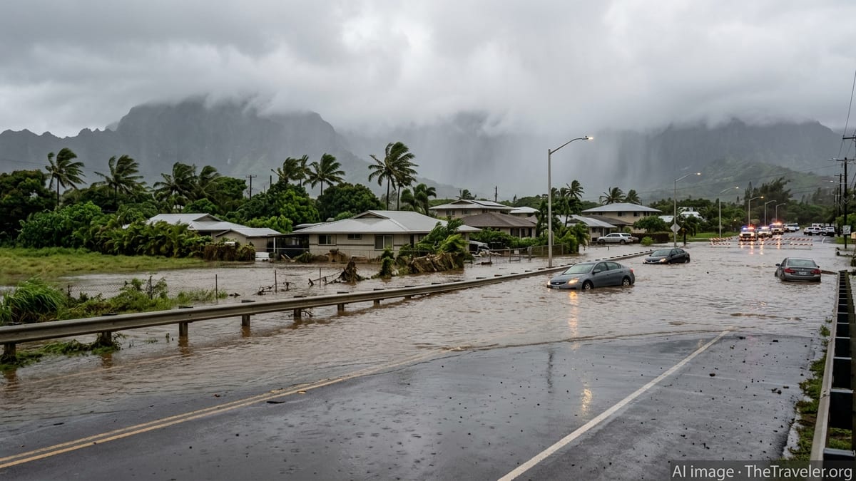
Heavy bands of rain associated with the Kona low began battering O‘ahu in recent days and intensified overnight into March 20, leading to rapidly rising waters across the island’s windward and northern communities. Publicly available information shows that streets, low-lying neighborhoods, and coastal areas on the North Shore have been hit especially hard, with muddy floodwaters overrunning drainage systems and flowing into homes and businesses.
According to published coverage, parts of Hale‘iwa and nearby North Shore communities have seen vehicles swept from roadways and structures knocked off their foundations as runoff from the Ko‘olau Range surged toward the coast. Reports indicate that several feet of standing water have rendered some residential streets impassable, with debris, silt, and damaged infrastructure complicating early cleanup efforts.
Weather discussions from the National Weather Service and local forecast outlets describe the current Kona low as one of two back-to-back systems affecting Hawai‘i in March, with already saturated ground on O‘ahu allowing new rainfall to run off quickly rather than soak in. This pattern has increased the likelihood of flash flooding and stream overflows, particularly on the North Shore, where inland watersheds drain toward coastal plains and popular surf towns.
Local community reports describe the scene as catastrophic in some pockets of the North Shore, with floodwaters surging through familiar tourist routes, engulfing parking areas and cutting off access to surf breaks and beach parks that are normally crowded with visitors.
Evacuation Zones Downstream of Wahiawā Dam
One of the most serious concerns arising from the storm has centered on the condition of Wahiawā Dam, located inland above O‘ahu’s North Shore communities. According to widely shared emergency updates and news coverage on March 20, the reservoir reached dangerously high levels, prompting urgent evacuation orders for thousands of people living downstream in parts of Waialua and Hale‘iwa.
Publicly available information indicates that residents in designated evacuation zones were instructed to leave immediately due to the risk that the aging dam could fail under the stress of extreme inflows. Maps and local reporting identify portions of Hale‘iwa between Pua‘ena and Kamehameha Highway, as well as low-lying areas of Waialua closer to the shoreline and river channels, among the areas most at risk from potential downstream flooding.
Travelers staying in vacation rentals, small inns, and surf camps within these zones have been urged by local advisories and community groups to relocate to higher ground or move toward urban Honolulu until conditions stabilize. Visitors unfamiliar with the island’s floodplains have been encouraged to consult local announcements, hotel notices, and broadcast updates to confirm whether their accommodation lies within any current evacuation area.
Reports from the scene note that evacuation traffic has placed additional strain on the island’s limited road network, particularly where narrow bridges and coastal stretches intersect with inundated zones. Even outside formal evacuation boundaries, some residents and visitors have chosen to move voluntarily to safer locations due to fast-changing water levels and the ongoing risk of landslides and road washouts.
Road Closures, Disrupted Travel, and Visitor Safety
The storm has severely disrupted surface travel around O‘ahu, with several key routes on the North Shore and central parts of the island affected by inundation. Community updates and traffic reports describe Kamehameha Highway, the essential coastal road linking Hale‘iwa to other parts of the island, as partially cut off in segments where floodwaters have overtopped the pavement or undercut shoulders.
In addition, access roads into residential neighborhoods and popular beach parks have been blocked by standing water, debris, and localized sinkholes. Some bridges and stream crossings are under close observation or temporarily closed due to high flows and concerns over structural stress. These disruptions have stranded some vehicles and limited the ability of residents and visitors to move in and out of the North Shore area.
Travel industry notices and local tourism forums are advising visitors currently on O‘ahu to avoid nonessential travel to the North Shore until conditions improve. Travelers staying in Waikīkī, Ko Olina, or other resort areas on the leeward side of the island are being encouraged to remain where they are rather than attempting scenic drives or day trips into affected zones while flood warnings and road closures remain in effect.
For those whose flights or inter-island plans intersect with the storm, airlines and accommodations are reported to be reviewing change policies as the situation evolves. Visitors are being urged to check with their hotels and transportation providers before setting out, allow extra time for any necessary travel, and be prepared for last-minute diversions or delays caused by flooded roadways and traffic congestion.
Continuing Hazards: Flash Flooding, Contaminated Water, and Landslides
Forecasters expect the Kona low pattern to linger, with additional rounds of showers and thunderstorms possible through the weekend. Weather outlooks compiled from National Weather Service discussions and regional forecast platforms indicate that soils across O‘ahu remain highly saturated, meaning that even moderate new rainfall could lead to renewed flash flooding, stream rises, and dangerous runoff.
Beyond the immediate threat from fast-moving water, reports from across the state point to significant water quality concerns. Brown-water conditions have been documented at numerous beaches in recent days, including around O‘ahu, where storm runoff has carried sediment, debris, and in some locations sewage overflows into nearshore waters. Health advisories warn that swimming, surfing, or wading in discolored water can carry a heightened risk of illness due to bacteria and other contaminants.
The combination of saturated slopes, undercut stream banks, and ongoing rain also raises the risk of landslides, rockfall, and erosion in steep terrain above roads and communities. This is of particular concern on the windward and northern sides of O‘ahu, where narrow valleys and cliff-lined highways hug the coastline. Travelers are being urged to treat any posted closure or warning seriously, avoid parking under unstable hillsides, and remain alert for falling rocks or sudden debris flows.
Power outages and localized utility disruptions have also been reported in some neighborhoods, adding to challenges for both residents and visitors. Travelers staying in smaller properties without backup power may experience temporary interruptions to air conditioning, internet service, and refrigeration, and are advised to conserve phone batteries and keep essential items easily accessible in case of further outages.
Guidance for Current and Upcoming Visitors to O‘ahu
For travelers already on O‘ahu, publicly available advisories emphasize a few key points: stay out of designated evacuation zones on the North Shore, avoid driving through flooded intersections or around barricades, and do not attempt to cross fast-moving water on foot or in vehicles. Even shallow floodwaters can conceal washed-out pavement, sharp debris, or strong currents capable of sweeping cars off the road.
Visitors with upcoming trips in the next several days are encouraged to track the evolving forecast, review the status of flood watches and warnings, and remain flexible with daily plans. Popular outdoor activities such as hiking, waterfall visits, and river kayaking may be unsafe or temporarily closed due to high water and trail damage. Travelers are advised to prioritize safety over itineraries and to choose activities in less-affected areas once conditions begin to improve.
Those considering last-minute travel changes are turning to airlines, hotels, and travel agents to understand rebooking or cancellation options in light of the storm. While O‘ahu’s major resort districts and the island’s primary airport remain open, the widespread impacts of flooding, especially on the North Shore, mean that experiences may differ significantly from typical conditions in the short term.
As the Kona low system gradually weakens, cleanup and assessment across the North Shore and other hard-hit communities are expected to take time. Until floodwaters fully recede, infrastructure is inspected, and evacuation zones are lifted, travelers are being urged to approach O‘ahu with heightened awareness, respect for local conditions, and a willingness to adjust plans to support both personal safety and community recovery.