
More news on this day
A powerful Kona low storm system has unleashed Hawaii’s most severe flooding in more than two decades, inundating communities from Oahu’s North Shore to Maui, Molokai, Lanai and the Big Island, while rising waters at Oahu’s aging Wahiawa Dam have prompted mass evacuations and urgent safety warnings.
Get the latest news straight to your inbox!
Widespread Flooding From Oahu North Shore To Neighbor Islands
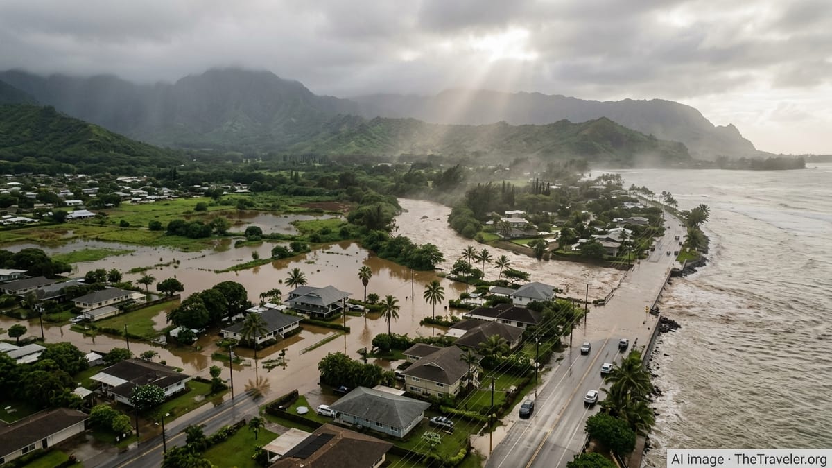
Over the past week, a slow-moving Kona low has drenched the Hawaiian Islands with repeated bands of heavy rain, saturating steep terrain and low-lying coastal plains alike. Publicly available information shows that parts of Oahu, including the North Shore and central plateau, have endured some of the heaviest totals, with muddy floodwaters pouring through neighborhoods and across key roadways.
Reports indicate that this system follows an earlier winter storm that had already primed the landscape with soaked soils. As the latest round of downpours arrived, runoff intensified quickly, filling streams and drainage channels and sending water into homes, businesses and agricultural lands. Observers describe it as the most extensive flooding event to affect the state in roughly 20 years, with damage still being tallied.
Beyond Oahu, the reach of the storm has been regional. Forecast discussions and local coverage describe elevated flood risk extending across Maui County, including Molokai and Lanai, and into Hawaii Island. The multi-island footprint of the event reflects the broad circulation of the Kona low, which has funneled deep tropical moisture over large areas for days.
Travel and essential services have been severely disrupted in pockets across the state. Low-lying roads have intermittently closed, while residents and visitors have faced detours, shelter operations and repeated alerts as additional rain bands continue to sweep through the archipelago.
Wahiawa Dam At Center Of Oahu’s Flood Emergency
At the heart of Oahu’s emergency is the Wahiawa Dam, a more than century-old structure that forms Wahiawa Reservoir above the communities of Waialua and Haleiwa. According to published coverage, intense runoff from the central mountains has driven reservoir levels near critical thresholds, triggering high concern about the dam’s ability to safely contain the surge.
Emergency alerts issued on Friday, March 20, and into the weekend warned of an imminent threat of failure or life-threatening flooding downstream if water levels continued to rise. Sirens sounded along the North Shore and text alerts urged people in designated inundation zones to move to higher ground. Subsequent updates indicated that water levels at the dam had begun to recede at times, but officials extended warnings and evacuation advisories as additional rounds of heavy rain remained in the forecast.
Publicly available regulatory documents had long noted deficiencies at Wahiawa Dam, including its age and the need for upgrades to meet modern safety standards. The current event has brought those concerns into sharp focus, as billions of gallons of water pooled behind the structure while downstream communities managed both ongoing flash flooding and the possibility of a rapid release.
Monitoring data shared through local media and community channels suggest that reservoir height has fluctuated just below the elevation associated with overtopping or structural failure. While a catastrophic breach has not been confirmed, the combination of aging infrastructure and extreme inflows has added a layer of anxiety to an already dangerous flood situation.
Mass Evacuations And Shelter Operations Across The Islands
As floodwaters rose and dam alerts escalated, evacuation orders and advisories rippled across parts of the state. On Oahu, reports indicate that roughly 5,500 residents north of Honolulu were urged to leave flood-prone neighborhoods near streams and low-lying coastal areas on March 20 and March 21, including sections of Waialua, Haleiwa and the wider North Shore.
Community updates shared through local news outlets and online forums describe residents being directed toward school campuses and community centers converted into evacuation shelters. One shelter at Waialua High and Intermediate School reportedly had to be relocated due to encroaching floodwaters, requiring buses to move evacuees and their pets to a safer site.
Parallel advisories emerged on neighboring islands as the Kona low shifted eastward. On Maui, publicly available information shows that an evacuation advisory for parts of Lahaina, still rebuilding from the devastating 2023 wildfire, was upgraded to a warning when stormwater retention basins neared capacity. Shelters have also been activated on Hawaii Island, particularly in the Kona and leeward districts, to accommodate residents in areas where intense rainfall and runoff closed roads and threatened homes.
Despite occasional periods of blue sky and receding waters, emergency managers have cautioned that conditions can deteriorate quickly when new rain bands arrive. The on-and-off nature of the evacuations, with some orders lifted and later reinstated, has created an extended period of uncertainty for communities already facing property damage and disrupted livelihoods.
Maui, Molokai, Lanai And Big Island Feel The Storm’s Secondary Impacts
While Oahu’s North Shore and the Wahiawa Dam have drawn national attention, the broader island chain continues to experience significant yet more dispersed impacts from the Kona low. On Maui, heavy showers have triggered localized flash flooding, particularly in West Maui and windward valleys where steep topography funnels runoff into narrow gulches.
According to weather updates compiled from public sources, Molokai and Lanai have also seen rounds of intense rain and thunderstorms, along with hazardous surf and strong southerly winds typical of Kona systems. These conditions have complicated inter-island travel and nearshore activities, with harbors, coastal roads and small communities contending with pounding rain and rough seas.
On the Big Island, the storm’s influence has been most pronounced along the Kona and windward districts, where saturated slopes have sent water cascading onto highways and through rural subdivisions. Community reports mention intermittent closures along key corridors such as parts of Highway 11 and other low-lying segments that are vulnerable during prolonged wet periods.
The cumulative effect across Maui, Molokai, Lanai and Hawaii Island is a patchwork of flooded fields, damaged infrastructure and ongoing repair work. While many of these impacts are smaller in scale than the catastrophic scenes on Oahu’s North Shore, together they underscore how a single Kona low can strain resources throughout the state’s far-flung island communities.
Climate Context And What Comes Next For Travelers
Climatologists and disaster-planning documents have increasingly highlighted the role of Kona lows and other extreme rainfall events in Hawaii’s future. Research cited in public reports notes that human-driven climate change is likely contributing to an uptick in the intensity of heavy downpours across the islands, even as overall annual rainfall patterns shift.
This latest event aligns with that pattern, arriving on the heels of earlier winter storms and delivering exceptional rain totals over a relatively short period. The resulting floods have tested aging infrastructure, including dams, drainage systems and rural roads, and raised questions about long-term resilience for both residents and the tourism economy that underpins many coastal towns.
For travelers, the unfolding situation is a reminder to approach island itineraries with flexibility during Hawaii’s wet season. Airlines, resorts and tour operators have been adjusting schedules and activities in response to road closures, brown-water advisories at beaches and access restrictions near affected communities. Public advisories recommend checking the latest local forecasts and any county-level emergency updates before setting out, especially when traveling to or from the Oahu North Shore, West Maui, windward valleys or rural districts on the Big Island.
As of March 22, 2026, forecasts indicate that the Kona low remains in the region, with additional showers and thunderstorms possible over the coming days. While some evacuation orders have been lifted and waters have receded in select areas, the threat of renewed flash flooding and changing dam conditions keeps much of Hawaii on alert, turning what would normally be a peak travel period into a test of the islands’ preparedness and adaptability.