
Lake Huron is where Ontario’s cottage country softens into sweeping sand beaches, secluded islands, and low‑key harbor towns that still feel closely tied to the water. Stretching from the Bluewater Coast north to the Bruce Peninsula and east into Georgian Bay, this shoreline offers an appealing alternative to the busier Great Lakes: vast skies, translucent shallows, pine‑lined cliffs, and communities that welcome visitors but have not been completely reshaped by tourism. This guide explores the quieter side of Lake Huron, with a special focus on Georgian Bay and the small towns that give the coast its character.
Understanding Lake Huron and Georgian Bay
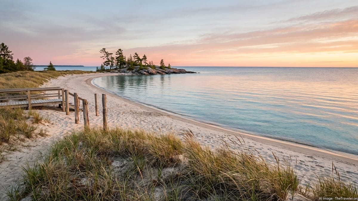
Lake Huron is one of the five Great Lakes, bordering Ontario on the Canadian side and Michigan in the United States. Its shoreline is deeply indented by peninsulas and bays, the largest of which is Georgian Bay, occupying the lake’s northeast corner. Georgian Bay is sometimes called the sixth Great Lake for its size and distinctive character: granite headlands, windswept pines, and thousands of islands that shelter clear channels of pale turquoise water. To the west, Lake Huron’s main body offers long sand beaches, sandbar‑sheltered shallows, and broad horizons where sunsets seem to swallow the sky.
The coast is usually divided into a few informal regions. The “Bluewater” and Bruce coastlines run north from Sarnia past Kincardine, Sauble Beach, and the Bruce Peninsula to Tobermory. Georgian Bay curves from the southern shallows around Wasaga Beach and Collingwood, up through the Thirty Thousand Islands near Midland and Parry Sound, and on toward Manitoulin Island and Killarney. Throughout, the landscape shifts from farm country and dune systems to rugged Canadian Shield rock and dense mixed forest, offering a surprising amount of variety within a relatively compact area.
Weather on Lake Huron can change quickly. Summers are typically warm and humid, moderated by lake breezes, with July and August the peak months for swimming. Spring and autumn bring cooler air, migrating birds, and fewer visitors, while winter transforms parts of the coast into a quiet, snow‑covered landscape suited to Nordic skiing, snowmobiling, and storm watching. Conditions on the open water can be windy and rough even in fine weather, so paddlers and boaters should always follow local forecasts and know their route and abilities.
Environmentally, Lake Huron and Georgian Bay remain relatively clean compared with more industrialized sections of the Great Lakes, but pressures from shoreline development, invasive species, and heavy summer use are real. Many communities and park agencies emphasize low‑impact travel, from maintaining dune vegetation to careful use of anchorages and designated campsites. Visitors who respect closures, keep to marked trails, and minimize waste help sustain the clarity and wild feel that make the lake so alluring.
Quiet Western Shores: Bluewater Coast to Bruce Peninsula
South of the Bruce Peninsula, Lake Huron’s western shore is lined with farming towns and modest cottage communities fronted by long beaches of pale sand. Places such as Grand Bend, Goderich, Kincardine, and Point Clark offer an accessible introduction to the lake, with waterfront parks, historic lighthouses, and gradual‑shelving shorelines that are especially appealing to families. In summer, beaches can be busy around main access points, but step away from central parking lots and you often find quieter stretches where dune grass sways and the only sound is surf.
As you drive north, the coast becomes more rugged and forested, edging into the limestone spine of the Bruce Peninsula. Sauble Beach, near the base of the peninsula, is one of the region’s best‑known summer resort communities, with more than 10 kilometers of sandy shoreline and shallow water warmed by offshore sandbars. The main strip can feel lively on hot weekends, but side streets and nearby backroads quickly return to a slower rhythm of cottages, marshes, and pine thickets. Just inland, conservation areas protect wetlands and remnants of rare Great Lakes shore ecosystems.
The Bruce Peninsula itself narrows between Lake Huron and Georgian Bay, culminating at Tobermory, a compact harbor town framed by cliffs and coves. Here, the western shore’s open‑lake feel blends with the clearer, cooler waters of Georgian Bay. Even at the height of summer, scenery just outside town retains a wild, almost northern quality: cedar‑fringed limestone edges dropping to deep water, orchids and ferns in shaded crevices, and night skies that can still show the Milky Way when conditions cooperate. If your idea of a perfect Lake Huron day involves hiking, paddling, and finishing with fish and chips on a working harbor, this corner of the coast delivers.
Outside peak summer, the western shore quiets noticeably. In late spring and early autumn, you may find yourself walking nearly empty beaches under changing skies, with migrating waterfowl on the move and local residents outnumbering visitors. Many businesses operate with reduced hours outside July and August, so advance checks and flexible plans are helpful. The reward is space, more accessible accommodation rates, and a sense of experiencing these communities closer to their everyday selves.
Georgian Bay’s Wild Heart: Bruce Peninsula and Fathom Five
Georgian Bay begins to reveal its distinct personality around the Bruce Peninsula’s northern tip. On the bay side, water appears noticeably clearer and often a deeper blue‑green, with submerged rock shelves visible beneath the surface. Along this shore, Bruce Peninsula National Park and Fathom Five National Marine Park protect some of the most dramatic scenery on Lake Huron: wave‑cut cliffs, sea caves, and offshore islands set in shockingly clear water. Well‑marked trails lead to iconic viewpoints, while boat tours and water taxis provide access to islands and snorkeling areas.
Near Tobermory, Fathom Five National Marine Park safeguards a cluster of islands and historic shipwrecks that have made the area a destination for divers and glass‑bottom boat tours. Visibility is often excellent, and even non‑divers can peer down on old hulls and anchors resting on the lake bed. Flowerpot Island, named for its eroded rock pillars, is one of the bay’s most photographed landmarks, reached by tour boat from Tobermory’s harbor. Trails on the island offer tight loops to viewpoints and backcountry corners where you can step away from crowds for a moment of quiet above clear water.
On land, Bruce Peninsula National Park stretches along the bay side south of Tobermory, with day‑use access points and longer trails that trace the escarpment edge. Routes range from short walks to viewpoints over sheltered coves to more demanding sections of the Bruce Trail that require sturdy footwear and attention to footing. Boardwalks and signed lookouts help concentrate use, but visitors should still expect uneven rock, variable weather, and the possibility of sudden fog or wind off the bay. Park managers typically promote advance reservations for popular attractions during summer, reflecting the balance they try to strike between access and protection.
For those seeking a quieter experience of Georgian Bay’s wild heart, shoulder seasons can be ideal. Early June, September, and even fair October weekends bring cooler temperatures, fall colors in mixed hardwoods, and significantly lighter visitation than mid‑July. Water is cold for swimming at these times, and some commercial operators reduce schedules, but trails are less congested and campsites easier to secure. Dress for rapid weather changes and shorter daylight, and you can experience the escarpment and islands with more solitude.
Southern Georgian Bay: Wasaga Beach, Collingwood, and Nearby Towns
At the southern end of Georgian Bay, the landscape softens again into long arc beaches and river mouths. Wasaga Beach, lining the south shore of Nottawasaga Bay, is widely recognized as one of the world’s longest freshwater beaches, with around 14 kilometers of sand broken into several managed sections. Much of the beachfront lies within a provincial park, which provides basic facilities and helps protect dune systems behind the beach. Summer visitors spread out along the numbered beach areas, choosing between livelier zones close to shops and quieter stretches where families picnic under shade trees and wade in shallow water.
The town of Wasaga Beach has been evolving in recent years, with efforts to refresh older commercial strips and expand year‑round amenities. New recreation facilities and a growing network of trails reflect the area’s shift from purely summertime resort to a more permanent community. Still, the mood remains casual and beach focused. Warm, relatively shallow water and gentle surf make this one of Georgian Bay’s most accessible spots for young children and tentative swimmers, though storm conditions can create strong currents that demand caution.
West of Wasaga, Collingwood and neighboring towns bridge the bay and the Niagara Escarpment. Collingwood’s historic downtown, working harbor, and proximity to ski slopes and cycling routes make it an all‑season base. In summer, boaters use the harbor as a jumping‑off point to explore the bay, while paddlers head for sheltered inlets and nearby wetlands. Rail‑to‑trail conversions and shoreline paths connect neighborhoods and viewpoints, and cafes, breweries, and small galleries give the town a lively feel in the evenings, especially on weekends.
Smaller communities along this stretch, including those in nearby townships, offer quieter public beaches, conservation areas, and marinas. Many lack the extensive facilities of larger resort towns, which is precisely their charm. Visitors who do not mind packing their own picnic or walking a little farther from roadside parking are often rewarded with less crowded waterfronts and a more local atmosphere. Regardless of which town you choose, respect for posted parking regulations and beach rules is important, as these communities juggle welcome tourist income with the daily needs of residents.
Thirty Thousand Islands and the Eastern Georgian Bay Coast
North of the southern bays and resort towns, Georgian Bay becomes a labyrinth of islands, channels, and rocky points commonly known as the Thirty Thousand Islands region. Communities such as Midland, Penetanguishene, and Parry Sound serve as gateways to this maze, providing marinas, outfitters, and day‑cruise operators. The landscape here is classic Canadian Shield: pink and gray granite worn smooth by glaciers, twisted pines clinging to cracks in the rock, and narrow passages of water that glitter under the sun. It is one of the most celebrated freshwater archipelagos in the world and a core part of a UNESCO‑recognized biosphere reserve near Parry Sound.
From these coastal towns, boat tours navigate among the islands to showcase lighthouses, summer cottages, and quieter inlets where wildlife is more easily spotted. Paddlers and small‑boat owners can weave through sheltered routes in calm weather, though open channels and changing winds demand experience and proper safety gear. The mood on the water is generally unhurried, with many visitors content to drift, photograph, or simply sit on warm rock and watch the play of light on ripples and stone. Late afternoon and early evening rides, when the sun drops low and long shadows scratch across granite, are especially memorable.
Onshore, cultural attractions tell the story of how people have lived with Georgian Bay’s waters for centuries. Historic sites and interpretive centers in the Midland and Penetanguishene area explore Indigenous history, early European settlement, and the fur trade era. In Parry Sound, waterfront walking paths, performance venues, and museums connect contemporary life to the bay’s shipping, logging, and fishing past. Summer festivals and outdoor concerts make the most of warm evenings, drawing both residents and visitors to piers and park lawns.
Further north, the coast stretches toward Killarney Provincial Park and Manitoulin Island, remote enough to feel like a different world yet still reachable by car and ferry connections. This upper section of Georgian Bay is less densely populated and several degrees wilder. Campgrounds, backcountry portage routes, and small marinas are more widely spaced, and services such as fuel, groceries, and repairs may require longer detours. For travelers comfortable with that trade‑off, the reward is a sense of space and sky that grows with every kilometer, and nights where loons and wind through the trees replace the hum of highways.
Coastal Towns, Culture, and Local Flavors
One of Lake Huron’s greatest attractions lies not only in its scenery but also in the string of small towns and villages that dot its shoreline. Each community offers its own take on what it means to live beside a vast lake: fishing harbors lined with tugs and charter boats, main streets with independent outfitters and ice cream stands, farmers’ markets that fill in summer with fresh produce and lake‑inspired crafts. Even where cottage development has grown substantially, the scale of settlement is still human, and it is easy to stroll from your accommodations to the waterfront for a sunset or morning coffee.
Local food often reflects a mix of agricultural hinterlands and Great Lakes fisheries. Menus may highlight lake‑caught whitefish, pickerel, or trout alongside produce from surrounding farms. Seasonal roadside stands sell berries, sweet corn, and preserves, while small breweries, cideries, and bakeries diversify dining options in larger centers such as Collingwood, Parry Sound, or Midland. As tourism becomes a year‑round part of the economy, more cafes and restaurants are staying open outside high summer, though winter hours can still be limited in smaller towns.
Cultural life tends to peak between late spring and early fall, when outdoor festivals, markets, and music events can take advantage of more reliable weather. Harborfront performance centers, local theatres, and community halls host concerts that range from classical and folk to contemporary bands. Art galleries along the coast frequently display works inspired by the lake and Georgian Bay’s distinctive rock and pine vistas. Indigenous artists and knowledge keepers are increasingly visible in regional events and programming, helping visitors understand long‑standing connections to the land and water.
Respectful interaction with local communities is essential. Busy weekends can strain small‑town infrastructure, from parking and waste services to emergency response. Simple steps such as using designated lots, carrying out trash, and supporting local businesses where possible contribute positively to the sustainability of tourism. Talking with residents, asking for recommendations, and learning a bit about local history also tend to open doors, turning a simple beach stop into a richer, more memorable visit.
Outdoor Activities: From Beach Days to Backcountry Trips
Lake Huron and Georgian Bay are built for time outside, with options ranging from relaxed beach afternoons to serious backcountry journeys. At the gentler end of the spectrum, families can spend full days swimming, building sandcastles, and walking shoreline trails at places like Wasaga Beach, Sauble Beach, or smaller municipal parks scattered along the coast. Many beaches feature accessible paths, washrooms, and clearly marked shallow areas, making them suitable for a wide range of visitors. Even so, water safety remains important, as lake conditions and near‑shore currents can change rapidly with shifting winds.
Hiking is another major draw, especially along the escarpment and in provincial and national parks. Sections of the Bruce Trail and local networks near Collingwood, the Bruce Peninsula, and further north around Killarney provide short lookouts and longer day hikes. Surfaces are often rocky and can be slippery when wet, so sturdy footwear and a cautious pace are recommended, particularly near exposed cliffs above Georgian Bay. Many trailheads feature signage detailing distances, difficulty levels, and natural features, helping walkers choose routes that match their abilities and schedules.
On the water, paddling offers a close‑up experience of the lake’s character. Calm mornings on sheltered bays are ideal for stand‑up paddleboarding and recreational kayaking, while more experienced paddlers venture into the island networks of eastern Georgian Bay or the deeper inlets of the Bruce Peninsula. Hiring a local guide or joining an organized tour is a good way to learn safe routes, weather patterns, and low‑impact shoreline practices. Powerboaters and sailors, meanwhile, can plan multi‑day cruises between marinas and anchorages in the Thirty Thousand Islands, Manitoulin Island, and other coastal hubs, always with attention to navigation hazards and quickly changing conditions.
In winter, selected parts of the Lake Huron and Georgian Bay coast shift focus to snow. Trail systems convert to Nordic skiing or snowshoeing routes, and inland networks open for snowmobiling. Lakeshore parks often remain accessible for walking and photography, though facilities are reduced and icy surfaces demand caution near the water’s edge. Storm watching has become a quiet niche activity, with some visitors timing stays around powerful low‑pressure systems that send dramatic waves crashing against breakwalls and headlands. Anyone considering this should keep a safe distance from the shoreline and follow local guidance about closures.
Planning Your Lake Huron and Georgian Bay Trip
Planning a Lake Huron getaway begins with choosing the rhythm and setting that suit you best. For classic summer beach holidays with easy access to amenities, look to places like Wasaga Beach, Sauble Beach, and the communities of the southern and central western shore. Those drawn to hiking and dramatic scenery may prefer basing themselves near Tobermory or along the escarpment, while travelers seeking boating and island exploration often gravitate toward Midland, Penetanguishene, and Parry Sound. Mixing a few nights in busier hubs with stays in quieter cottage country can provide a balanced view of the region.
Accommodation ranges from simple motels and family‑run inns to resorts, rental cottages, campgrounds, and in some areas yurts or backcountry sites. Peak summer, particularly late July and early August, sees the highest demand, and many waterfront properties book well in advance. Outside those weeks, especially in June and September, availability improves and rates can moderate, though some smaller operators reduce services or close entirely after Labor Day. Campers should check reservation systems for provincial and national parks, which often require advance bookings for popular sites.
Getting around typically involves driving. Public transit connects some larger centers, but many beaches, trailheads, and viewpoints sit beyond bus routes. Road conditions are generally good, though summer construction and weekend traffic around resort towns can slow travel. Distances may look small on a map yet take longer than expected, particularly along two‑lane highways that pass through numerous small communities. Building in extra time makes it easier to stop at unplanned roadside lookouts, farm stands, and harbor piers along the way.
Sensible packing helps make the most of a Lake Huron trip. Even in midsummer, evenings near the lake can be cool, so layers are useful. Sturdy footwear, sun protection, refillable water bottles, and waterproof bags for electronics are all practical. For shoulder‑season visits, add warmer clothing, rain gear, and traction aids if you plan to hike on rocky or potentially icy surfaces. Finally, travel insurance and emergency roadside coverage can provide peace of mind in remote stretches where services may be sparse.
The Takeaway
Lake Huron and Georgian Bay offer a version of Ontario’s waterfront that remains relatively spacious, diverse, and quietly compelling. From the long, shallow beaches of the southern coast to the carved limestone of the Bruce Peninsula and the granite islands of eastern Georgian Bay, the shoreline changes character repeatedly, yet always returns to the same essentials: fresh water, wide skies, and communities that live by the rhythm of the lake.
Whether you are drawn to simple beach days, ambitious island‑hopping journeys, or evenings wandering small‑town harbors after a plate of local fish, this corner of the Great Lakes is well suited to unhurried travel. Planning ahead for peak summer, traveling lightly on the landscape, and staying flexible enough to respond to the weather will help you experience Lake Huron at its best. In the end, it is often the quiet moments that linger: the echo of waves in a limestone cove, the feel of warm rock underfoot, or a sunset that seems to pause just a little longer over the lake’s broad horizon.
FAQ
Q1. When is the best time of year to visit Lake Huron and Georgian Bay?
The warmest and busiest period is from late June through August, ideal for swimming and beach days. For fewer crowds and cooler temperatures, consider late May to mid June or September, when many services are still available but the coast feels calmer.
Q2. Are the beaches on Lake Huron suitable for families with young children?
Many Lake Huron and southern Georgian Bay beaches have gradual slopes, sand bottoms, and relatively shallow water near shore, which suits families. Parents should still monitor children closely, as weather can create waves and currents, and always follow local safety signage.
Q3. Do I need a car to explore Lake Huron and Georgian Bay?
A car is highly recommended. While some larger centers have limited public transit, many of the most appealing beaches, lookouts, and trailheads are spread out along two‑lane highways and country roads without regular bus service.
Q4. Is the water warm enough for swimming in Georgian Bay?
In sheltered southern bays and shallow areas, water can feel comfortable for swimming by mid to late summer. Along more exposed shores and in the northern bay, temperatures stay noticeably cooler, so swimmers often limit time in the water or use wetsuits in shoulder seasons.
Q5. How far in advance should I book accommodations in popular towns?
For peak summer weekends in places like Wasaga Beach, Sauble Beach, Tobermory, and Parry Sound, booking several months ahead is wise, especially for waterfront rentals and campsites. Outside school holidays and in shoulder seasons, you may find more last‑minute options.
Q6. Are there options for travelers who prefer quieter, less crowded areas?
Yes. Smaller municipal beaches, conservation areas, and rural shorelines away from major resort towns typically see lighter use. Shoulder seasons, early mornings, and weekdays are also good times to experience popular spots with fewer people.
Q7. What safety considerations should boaters and paddlers keep in mind?
Weather on Lake Huron can shift quickly, so checking marine forecasts, wearing lifejackets, carrying communication devices, and knowing your route are all important. Paddlers should stay within their skill level, avoid long open‑water crossings in marginal conditions, and be aware of cold water risks.
Q8. Can I visit Lake Huron and Georgian Bay in winter?
Yes, but the experience is very different. Some towns maintain winter trails, lookouts, and basic services, while others partially shut down. Roads are generally maintained, but visitors should be prepared for snow, ice, limited daylight, and reduced accommodation and dining options.
Q9. How can I minimize my environmental impact while visiting?
Stay on marked trails, respect dune and vegetation fences, pack out your trash, use refillable water bottles, follow fire regulations, and support local conservation initiatives when possible. On the water, use established access points and avoid disturbing wildlife or sensitive shorelines.
Q10. Is Lake Huron a good destination for first‑time Great Lakes visitors?
Lake Huron is an excellent introduction. It offers classic Great Lakes scenery, varied beaches, and accessible towns, yet often feels less hectic than some other shorelines. With sensible planning and respect for local conditions, it is a manageable and rewarding destination for first‑timers.