
Lake Ontario may be the smallest of the Great Lakes by surface area, but its shoreline tells one of the region’s richest stories. From Toronto’s fast-changing waterfront and historic harbor towns in New York State to new protected waters, beaches and island escapes, the lake has become a dynamic destination where urban skylines, Indigenous heritage, and quietly restored wetlands meet.
Travelers find an accessible mix of big-city culture, small-town character and nature that still feels surprisingly wild in places.
Understanding Lake Ontario and Its Shores
Lake Ontario forms the eastern gateway of the Great Lakes, collecting the waters of the upper lakes before they pour through the St. Lawrence River toward the Atlantic. Its roughly oval shape stretches between Ontario in Canada and New York State in the United States, with a coastline that alternates between steep bluffs, working ports, soft-sand beaches and low, marshy deltas. For visitors, this geography means a wide variety of experiences within a manageable distance, especially if you follow the lake by car in stages.
Historically, these shores were key corridors for Indigenous nations, including the Haudenosaunee Confederacy and several Anishinaabe and Mississauga communities, well before European settlement. Later, the lake served as a strategic waterway for the fur trade, colonial wars and the growth of industrial cities. Today, remnants of that layered past are visible in lighthouses, canal infrastructure, military fortifications and compact 19th-century downtowns facing the water.
Although large industrial sites still occupy sections of shoreline, many communities have turned toward recreation and restoration. Waterfront districts that once held warehouses and rail yards now feature boardwalks, cycling paths, marinas and parkland. Ongoing ecological projects on both sides of the border are steadily improving water quality and reviving wetlands, which in turn draw migratory birds, fish and paddlers back to areas that were long off-limits.
Weather is part of the lake’s character. Conditions can shift quickly, with calm, glassy mornings giving way to choppy waves and strong winds by afternoon. In summer and early fall, that volatility can be thrilling for sailors and kiteboarders but demands respect from casual boaters. Winter transforms much of the shoreline into a quieter seascape of ice formations and snow-covered piers, while the open lake often remains partly ice-free, creating moody vistas that feel more like a northern sea than an inland lake.
Toronto: A Global City on the Lake
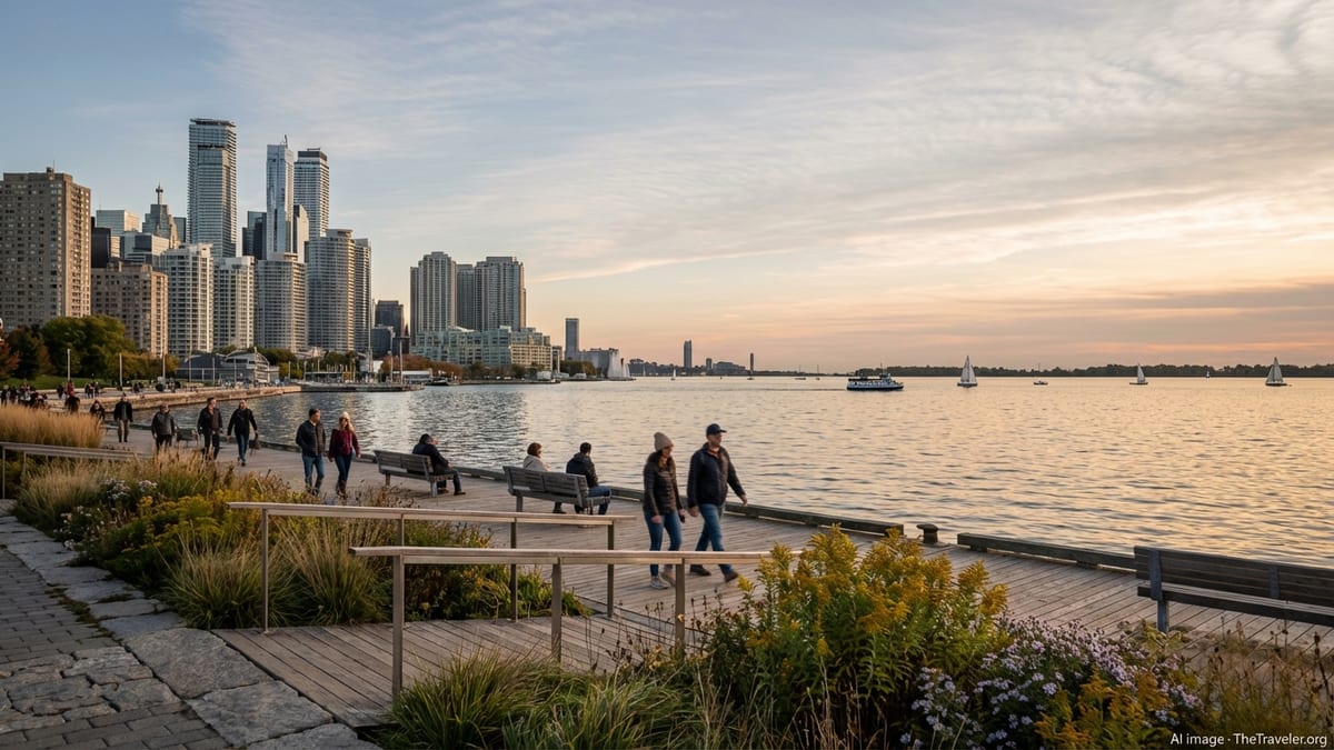
Toronto, the largest city on Lake Ontario, has spent the past two decades steadily turning back toward the water. What was once dominated by heavy industry and elevated expressways is now a patchwork of new parks, mixed-use neighborhoods and cultural spaces. Public investment in waterfront revitalization has been extended into the mid-2030s, with funding earmarked for additional housing, public realm improvements and new destinations along the harbor and inner shoreline. Visitors arriving today encounter a waterfront that is still evolving but already provides an impressive amount of accessible green space and pedestrian-friendly promenades.
Along the central harbourfront, a continuous ribbon of parks and plazas faces the downtown skyline. Ferries shuttle passengers to the Toronto Islands, a low chain of car-free islands with beaches, lagoons and views back toward the towers of the financial district. Nearby, reimagined industrial buildings house cultural venues, restaurants and seasonal events ranging from outdoor art installations to food festivals. The harbor itself hosts pleasure cruises, sailing schools and paddle craft, as well as commercial vessels delivering materials to the remaining port facilities.
To the west, districts such as Sunnyside and Humber Bay illustrate how urban shorelines can blend recreation and ecology. Beaches, public pools, rowing clubs and yacht clubs sit alongside bird-friendly parkland and restored shoreline habitat. Trails here connect to an extensive waterfront cycling route, allowing visitors to pedal for many kilometers with the lake in constant view. Morning and evening are particularly appealing times to visit, when soft light and long shadows flatter the skyline and the water is often calmer.
On the eastern side of downtown, a major project is reshaping the Port Lands and lower Don River. Engineers and landscape designers have been carving a new, more natural river channel and coastal wetland, reconnecting the river’s mouth to Lake Ontario and reducing flood risk to adjacent neighborhoods. As the channel is opened and new island parkland takes shape, early phases are already attracting wildlife and drawing attention as an example of large-scale urban ecological restoration. In the coming years, this area is expected to add more waterfront parks, trails and mixed-use spaces that travelers will be able to explore.
Canadian Waterfront Cities and Towns
Beyond Toronto, a series of smaller Canadian cities and lakefront communities offer a quieter, often more intimate relationship with the water. Mississauga’s Port Credit, sometimes branded as the “village on the lake,” combines a working marina with boardwalks, riverside trails and seasonal festivals. In summer, boat shows, music events and outdoor dining bring energy to the harbor, while nearby parks and trails remain popular with walkers and cyclists seeking open views across the lake.
Farther along the northern shore, cities such as Hamilton and smaller communities around the western end of the lake are steadily reclaiming industrial waterfronts. In Hamilton, for example, landscaped parks on the harbor provide curving pathways, integrated fish habitat and public access that did not exist a generation ago. These waterfront parks serve as front porches for the city, where residents fish from breakwalls, launch kayaks or simply watch the changing light on the water and the working harbor beyond.
Smaller Ontario towns along the north and east shores tend to have compact, walkable centers close to the water. Many feature century-old main streets, marinas and modest beaches or piers. Travelers can often park once and explore both town and waterfront on foot, moving easily between cafés, local shops and lakeside lookouts. While individual amenities vary, a consistent feature is the feeling that the lake is integral to daily life, whether through fishing, sailing, commuting or simply socializing along the shore.
These communities are also entry points to a growing network of regional trails and cycling routes. Portions of the Great Lakes Waterfront Trail follow the Lake Ontario shoreline, linking towns, conservation areas and urban parks. For visitors with time, exploring the lake by bicycle over several days offers a different perspective, with frequent chances to detour into beaches, cobblestone harbors or shaded picnic areas that motorists might miss.
New York’s South Shore and Historic Harbors
On the United States side, New York’s south shore of Lake Ontario has a more low-key atmosphere, with smaller cities, fishing villages and long stretches of rural shoreline punctuated by bluffs and river mouths. Rochester, the largest city on this side of the lake, connects to Lake Ontario via the Genesee River. Its harbor district combines marinas and waterfront dining with lakefront parks and a sizeable public beach. A short drive away, riverside trails and the remains of canal-era infrastructure hint at the region’s industrial and transportation history.
Continuing east, the shoreline passes through a succession of harbor towns and state parks. Communities such as Oswego and Sackets Harbor carry strong maritime and military legacies, reflected in preserved fortifications, interpretive centers and waterfront promenades. Their historic cores, with brick facades and narrow streets, sit close to the water and often orient around small marinas or public docks. Summer sees a rhythm of fishing tournaments, sailing regattas and community festivals that draw visitors from across the region.
Along this coast, state parks protect scenic headlands, stretches of beach and marshy inlets where migratory birds congregate. Many parks provide boat launches, picnic areas and simple campgrounds, offering a straightforward way to stay close to the lake without elaborate planning. Because these sites are spread along the shoreline, travelers can craft road trips that alternate between small-town stops and quieter nights near the water.
Weather and lake conditions are particularly important for visitors engaging in boating or shore fishing on this side of Lake Ontario. Offshore, the lake can develop short, steep waves when winds align with its length, and surface temperatures can remain surprisingly cool well into summer. Local marinas, visitor centers and charter operators are reliable sources for up-to-date advice on conditions, seasonal fish runs and recommended safety practices.
Thousand Islands and the St. Lawrence Gateway
At the lake’s eastern outlet, the landscape fractures into the famous Thousand Islands, a region where the waters of Lake Ontario spill into the St. Lawrence River. Here, wooded islands, shoals and channels create one of the most distinctive freshwater archipelagos in North America. The area stretches across the Canada–United States border, with parks, villages, and scenic lookouts on both sides. From the water, you see a blend of forested shorelines, historic cottages, colorful boathouses and prominent lighthouses marking key channels.
The Thousand Islands region has long been a summer destination, thanks to its combination of gentle cruising waters, sheltered anchorages and cool breezes. Visitors can explore by tour boat, water taxi, kayak or private vessel, navigating between islands that range from tiny rock outcrops to substantial, forested landscapes with established trail networks. Some islands are part of national or regional park systems, offering day-use facilities, campsites and short hiking paths with open views back toward Lake Ontario or up the St. Lawrence.
On the mainland, communities that face this island-studded waterfront serve as hubs for accommodation, dining and cultural experiences. Museums and interpretive centers highlight the maritime history of the region, its role in regional trade and the evolving relationship between shoreline communities and the waterway. Heritage sites, including grand “castle” homes built during the late 19th and early 20th centuries, add an architectural layer to the natural drama of granite outcrops and pine-fringed shores.
Because the Thousand Islands straddle an international boundary, many visitors combine Canadian and American stops in a single trip, crossing bridges or using local ports of entry. Travelers who plan to do this should verify current border requirements well in advance, including identification documents and any regulations affecting pets, recreational boats or fishing gear. The reward for that extra preparation is the ability to experience the distinct but complementary waterfront cultures on each side of the river.
Nature, Parks and the New Lake Ontario National Marine Sanctuary
While Lake Ontario’s cities absorb much of the attention, the broader shoreline and open waters offer significant natural experiences. Conservation areas and wetlands punctuate the coast, providing habitat for waterfowl, migrating songbirds and aquatic species. Some of these sites occupy the mouths of rivers and creeks, where marshes and lagoons filter runoff before it reaches the lake. Others are set back from the main shore, linked by short trails or boardwalks that lead visitors through reeds and sedges to quieter viewing platforms.
In September 2024, a large area of southeastern Lake Ontario off the New York coast was designated as the Lake Ontario National Marine Sanctuary. This federally protected sanctuary encompasses hundreds of square miles of water and protects a notable concentration of historic shipwrecks and other submerged cultural sites, as well as areas of importance to Indigenous communities. Management focuses on preserving this underwater heritage while supporting responsible tourism, education and scientific research.
For travelers, the sanctuary highlights a less visible dimension of the lake. Several communities along the protected shoreline serve as gateways to diving charters, maritime museums, lighthouse tours and interpretive exhibits that explain the stories behind the wrecks and navigation hazards. Local operators and visitor centers emphasize low-impact practices, from careful anchoring to respect for archaeological sites, and encourage visitors to appreciate the lake as a cultural landscape as much as a recreational one.
On the Canadian side, urban projects are also bringing back more natural shorelines within city limits. In Toronto’s Port Lands, newly constructed wetlands and meandering river channels are already drawing species such as waterfowl, amphibians and small mammals into spaces that were once dominated by fill and pavement. Environmental monitoring and Indigenous knowledge have informed plantings and habitat design, illustrating how even heavily modified shores can regain some ecological function when meaningful restoration is prioritized.
Recreation on and Along the Water
Recreation on Lake Ontario ranges from casual shoreline walks to more specialized pursuits such as open-water sailing, scuba diving and long-distance cycling. Urban waterfronts typically provide the most accessible entry points, with paved promenades, playgrounds and rental concessions for kayaks, paddleboards or small sailboats. In central Toronto and several New York harbors, seasonal water taxis and ferries expand the options, allowing passengers to reach islands or opposite shores without needing a vehicle.
Angling is a year-round presence on the lake and its tributaries, though specific seasons and regulations vary by jurisdiction. The lake supports recreational fisheries for species such as salmon, trout and bass, drawing both charter clients and shore-based anglers to key hotspots, especially during spring and fall runs. Visitors interested in fishing are generally advised to consult local authorities or outfitters for current licensing requirements, catch limits and consumption advisories, which are updated when conditions change.
For non-motorized enthusiasts, the combination of lakeside trails and connecting river corridors creates opportunities for multi-day cycling or paddle trips. Sections of the international Great Lakes Waterfront Trail and other regional routes follow the shoreline closely, weaving through parks and neighborhoods with frequent lake views. Paddlers can choose between urban harbors, sheltered bays, river mouths and, in suitable conditions, short crossings between islands or headlands. As always on large lakes, careful attention to weather forecasts, wind direction and water temperature is essential.
Winter brings a different set of experiences. While large expanses of Lake Ontario often remain partially ice-free, bays, harbors and wetlands can freeze, creating opportunities for skating, snowshoeing and photography. Lakeside parks take on a quieter feel, and icy spray can sculpt piers, breakwalls and shoreline vegetation into temporary natural art. Visitors should exercise extra caution around frozen water, as conditions can change quickly and safe ice thickness may vary significantly across short distances.
Planning a Trip Around the Lake
Because Lake Ontario spans an international border and includes several urban centers, planning a visit starts with clarifying which sections you hope to explore. Many travelers focus on a segment of coastline rather than attempting a full circuit. A long weekend might center on Toronto’s waterfront and nearby Ontario towns, while a week or more allows time to add Rochester, Oswego County, the Thousand Islands or smaller communities on either side.
Transportation options are varied. Major cities around the lake are connected by highways and, in some cases, intercity rail or bus services. Within urban areas, public transit, rideshare services and bike-share systems can reduce the need for a car, especially where waterfronts are compact and walkable. However, a personal vehicle remains the most flexible way to link smaller harbor towns, parks and viewpoints spread along the coast. In summer, parking near popular beaches and marinas can fill quickly, so early starts often make for easier days.
Accommodation ranges from downtown hotels with harbor views to family-run motels, lakeside cottages, campgrounds and short-term rentals. In popular areas, water-facing rooms and cabins book out well ahead of peak summer and fall weekends. Shoulder seasons in late spring and early autumn can be attractive, with milder temperatures, active foliage and generally lighter crowds, though some seasonal businesses may operate on reduced hours.
Travelers should also consider the practicalities that come with large bodies of water. Even on warm days, nearshore water temperatures can be cool enough to cause discomfort or hypothermia in extended swims. Weather patterns can shift rapidly, turning calm afternoons into windy, wave-tossed evenings. Checking marine forecasts, packing layers and having contingency plans for indoor activities in nearby cities or towns can help ensure a smoother experience, regardless of conditions.
The Takeaway
Lake Ontario rewards travelers who enjoy contrasts. In a single trip, you can move from high-rise skylines to quiet piers, from restored city wetlands to undeveloped bluffs, from historic shipwreck stories to contemporary waterfront festivals. The lake’s compact size relative to the upper Great Lakes makes it feasible to combine multiple destinations without long days of driving, yet the variety of shorelines and communities keeps each section feeling distinct.
As investment in waterfront revitalization and ecological restoration continues, both Canadian and American shores are offering more ways to experience this inland sea up close. Whether you are drawn by urban culture, small-town charm, outdoor recreation or the evolving story of how communities are reconnecting with the water, Lake Ontario provides a rich, accessible introduction to the Great Lakes as a whole.
FAQ
Q1. Is Lake Ontario safe for swimming?
Water quality varies by location and season, but many designated public beaches are regularly monitored and posted when conditions are suitable for swimming.
Q2. When is the best time of year to visit Lake Ontario?
Late spring through early fall generally offers the most reliable weather for outdoor activities, with peak warmth in July and August and colorful foliage in October.
Q3. Do I need a car to explore Lake Ontario’s waterfront?
You can experience major urban waterfronts using public transit and walking, but a car provides greater flexibility to reach smaller towns, parks and rural stretches of shoreline.
Q4. Can I visit both the Canadian and U.S. sides in one trip?
Yes, many travelers combine both sides, but you must carry appropriate identification and comply with current border and customs requirements for people and any equipment you bring.
Q5. What is the Lake Ontario National Marine Sanctuary?
It is a federally designated protected area in southeastern Lake Ontario that conserves historic shipwrecks, cultural sites and marine resources while supporting research and tourism.
Q6. Are there ferries that cross Lake Ontario?
At present there is no regularly operating long-distance passenger ferry crossing the full lake, but local ferries and water taxis serve islands and short routes in several harbor areas.
Q7. Is Lake Ontario good for fishing?
Yes, the lake and its tributaries support popular recreational fisheries, though specific species, seasons and regulations differ by jurisdiction and should be checked locally.
Q8. How cold is the water in summer?
Surface temperatures near shore can feel comfortable on warm days, but upwelling and depth often keep the water cooler than many visitors expect, especially away from shallow bays.
Q9. Are there cycling routes along the lake?
Yes, sections of long-distance trails and regional bike routes follow the shoreline on both sides, connecting urban waterfronts, smaller communities and parks with lake views.
Q10. What should I pack for a Lake Ontario trip?
Pack layers for changing weather, comfortable walking or cycling shoes, sun protection, and, if you plan to go on the water, suitable gear such as life jackets and quick-drying clothing.