
More news on this day
A potent late season winter storm is sweeping across Ohio and Pennsylvania this week, delivering a disruptive mix of snow, ice, and strong winds that is threatening travel, power reliability, and daily routines for millions of residents.
Get the latest news straight to your inbox!
Heavy Snow, Ice, and High Winds Hit at an Awkward Time
Publicly available National Weather Service outlooks for March 17 to March 19 indicate that a vigorous Arctic air mass and fast moving low pressure system are combining to produce winterlike conditions across the lower Great Lakes and interior Northeast, including large parts of Ohio and Pennsylvania. Forecasts describe periods of snow, snow squalls, and mixed precipitation, accompanied by gusty winds and sharply colder temperatures for mid March.
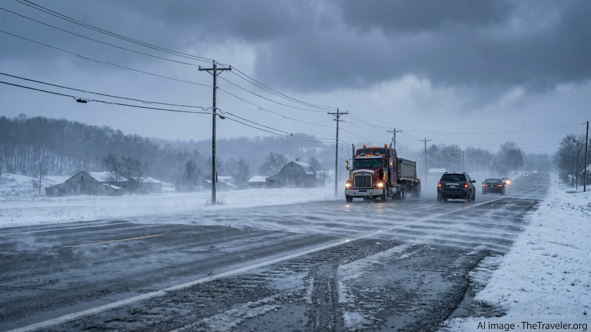
In central Ohio, including the Columbus region, reports describe breezy to very windy conditions with occasional snow showers and bands of heavier snow capable of briefly reducing visibility and making roads slick. Temperatures hovering in the 20s Fahrenheit are supporting accumulation on untreated surfaces, particularly in the morning and evening hours when road surface temperatures are lower.
Across western and central Pennsylvania, including the Pittsburgh area and higher terrain to the east, forecast discussions point to bursts of snow and localized snow squalls, with storm totals generally light but capable of creating hazardous travel where bands line up during commuting hours. Strong northwest winds behind the storm system are adding a significant wind chill factor, making conditions feel more like mid winter than the week before spring.
Farther north and in higher elevations of both states, colder air is supporting more persistent snow and patchy ice, especially on secondary roads, bridges, and overpasses. Travel bulletins from transportation agencies and local media highlight scattered slide offs, fender benders, and speed reductions on major interstates as plow and treatment crews work through the changing conditions.
Travel Disruptions Threaten Commutes and Spring Break Plans
The timing of this late season outbreak is particularly challenging for travelers and commuters who had already shifted mentally into a spring pattern. Morning and evening drives on March 17 and March 18 are expected to be the most affected, as bands of snow and gusty winds overlap with peak traffic volumes on corridors such as Interstates 70, 71, 76, 77, 79, 80, and 90.
Transportation agency updates and local news coverage across Ohio and Pennsylvania describe reduced speed limits, scattered crashes, and periods of low visibility where snow squalls pass over major highways. In some lake effect prone areas downwind of Lake Erie, brief whiteout conditions are possible, especially in open stretches of road where strong crosswinds can blow snow back across cleared lanes.
Air travel is also at risk of disruption, particularly at regional hubs in Columbus, Cleveland, Pittsburgh, and smaller airports throughout the Ohio Valley. While the storm is not expected to produce crippling snow totals at these locations, even light accumulation combined with gusty winds and rapidly changing visibility can slow deicing operations and contribute to delays and cancellations. Travelers are being advised in public guidance to check flight status frequently and allow extra time to reach airports on potentially slick roads.
For those driving for late winter getaways or returning from spring break trips, the shift back to winter driving conditions may come as a surprise. Travel safety campaigns emphasize the importance of slower speeds, increased following distance, and readiness for sudden visibility drops, particularly in rural stretches where cell coverage and services may be limited.
Power Outages and Infrastructure Strain a Key Concern
Beyond roadway impacts, the combination of strong winds, cold air, and pockets of heavy, wet snow is posing a risk to above ground infrastructure across Ohio and Pennsylvania. Energy sector bulletins and media reports note that gusty northwest winds are expected to persist behind the passing low pressure system, with higher gusts on exposed ridges and along lakeshores.
Where snow is wetter and clings to trees and power lines, the added weight can increase the chance of limb breaks and localized outages. This threat is most notable in areas where temperatures hover near the freezing mark and precipitation transitions between snow and mixed wintry types. Utilities and emergency management planners typically consider these setups among the more problematic late season events, as trees may have begun budding and can catch more snow and ice.
Cold temperatures following the storm, with lows dropping into the teens and 20s Fahrenheit in many communities, add another dimension to the risk. Households that lose power may struggle to maintain safe indoor temperatures, especially in older homes or rural properties. Public information campaigns from state and local agencies routinely encourage residents to have flashlights, blankets, and backup charging options ready during such events.
Road salt supplies and maintenance budgets can also be strained by late season storms, particularly after an active winter. While many communities anticipate occasional March snow, a widespread, high impact event with strong winds and recurrent snow showers can require multiple treatment cycles, extending overtime for crews and equipment that were already transitioning toward spring maintenance work.
How Long Will the Winter Pattern Last?
Forecast guidance from the National Weather Service suggests that the most intense impacts from this late season storm will ease after midweek, with conditions gradually moderating by March 19 and into the following weekend. Outlooks for both Ohio and Pennsylvania point toward a slow rebound in temperatures, with highs returning to the 40s and 50s Fahrenheit and more rain than snow in subsequent systems.
However, meteorologists routinely caution that March and even early April can still produce sharp temperature swings and quick hitting wintry events, especially across the interior Northeast and Great Lakes. Cold air masses lingering over Canada and the northern Plains can occasionally surge southward, interacting with springtime storm tracks to generate brief returns to snow and ice, even as days grow longer and average temperatures rise.
For travelers and residents trying to plan the week, publicly available forecasts recommend monitoring local updates multiple times per day, as the narrow bands of heaviest snow and squalls can shift quickly and significantly alter conditions over short distances. Urban cores may see relatively minor accumulation, while nearby higher elevations or lake effect zones contend with periods of heavy snow and whiteouts.
Looking ahead, seasonal outlooks lean toward a gradual transition into a more typical spring pattern, but the current storm is a reminder that winter weather hazards can linger well past the meteorological end of the season. For those in Ohio and Pennsylvania, the abrupt return of snow, ice, and dangerous winds underscores the value of maintaining winter readiness kits and flexible travel plans until more stable warmth is firmly established.