
More news on this day
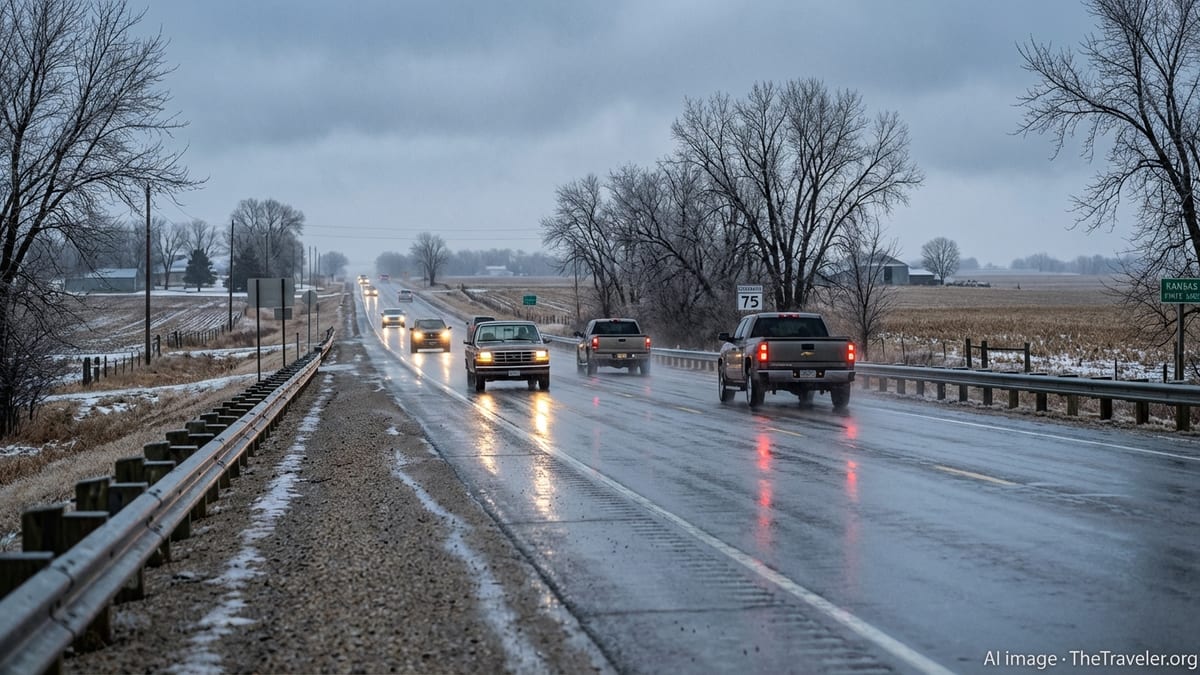
Weather forecasters are sounding the alarm that one of winter’s most deceptive hazards, a light glaze of ice, could catch drivers off guard across parts of Nebraska, Kansas and Missouri late Sunday into Monday, turning otherwise routine trips into dangerous journeys.
From Springlike Warmth to Stealthy Ice Hazard
After a stretch of unseasonably warm, almost springlike weather, a fast-changing storm setup is poised to bring a wintry mix back to the central Plains by late Sunday. Temperatures in the 60s and even low 70s on Saturday across portions of Kansas and Missouri will tumble as a cold front undercuts moist air riding in from the southwest.
That sharp temperature drop is expected to set the stage for a narrow zone of freezing rain and drizzle, mainly from late Sunday afternoon through early Monday morning. While forecast ice amounts are modest, often only a light glaze, meteorologists stress that even a thin film of ice can turn bridges, overpasses and untreated secondary roads into slick hazards.
National Weather Service offices in the region are highlighting the potential for mixed precipitation, including freezing rain, sleet and light snow, especially along and north of Interstate 70. In some areas of northern Missouri, a Winter Weather Advisory calls for snow totals generally under an inch but notes that any accompanying ice could be enough to cause travel disruptions during the Monday morning commute.
Farther west into eastern Nebraska, forecast discussions point to a similar pattern: relatively quiet, dry conditions during the day Sunday followed by pockets of freezing drizzle or light freezing rain overnight, particularly in low-lying areas and along river valleys where cold air tends to pool near the surface.
Why “Light” Ice Can Be More Dangerous Than Heavy Snow
While deep snowstorms and headline-grabbing blizzards often dominate winter news, experts say a light ice event can be every bit as dangerous for drivers, precisely because it is easy to underestimate. A transparent glaze of ice, sometimes described as black ice, can form without dramatic snowfall or obvious accumulation, leaving pavement that looks merely wet but is in fact frozen.
Forecasters note that this weekend’s setup is especially conducive to that kind of subtle hazard. Surface temperatures in many locations are expected to hover near the freezing mark, fluctuating between just above and just below 32 degrees Fahrenheit. In those situations, rain may fall as liquid but freeze instantly on elevated or shaded surfaces, leading to patchy ice.
Unlike major ice storms, which trigger widespread power outages and downed tree limbs, a light ice event may not cause visible damage to infrastructure. That lack of dramatic impact can lull motorists into complacency, even as crash reports spike on highways and local roads. Transportation officials across the three states say they are preparing to treat priority routes, but warn that even treated roads can become slick if freezing rain intensity briefly outpaces road crews.
Complicating matters is the timing. Many of the most troublesome icy spots may develop overnight into the early morning hours, when traffic is lighter and road condition changes are harder to spot. Commuters heading out around daybreak Monday in cities from Omaha and Lincoln to Wichita, Topeka, Kansas City and Columbia could encounter rapidly changing conditions within just a few miles.
Impact Zone: Key Travel Corridors at Risk
The focus of concern stretches across a broad swath of the central Plains and lower Missouri Valley, where northbound cold air undercuts lingering moisture from the departing system. In Nebraska, forecasters are watching corridors along Interstates 80 and 29, particularly across southeast Nebraska where a light glaze of freezing rain or drizzle is possible late Sunday night.
Across Kansas, the greatest risk for light icing appears centered on eastern counties, where temperatures are most likely to dip below freezing during the heaviest precipitation. Forecasters in the Kansas City area expect rain south of major east west routes during the day Sunday, with a transition to a wintry mix closer to and north of Interstate 70 by evening. Brief periods of freezing rain could quickly slick over ramps, flyovers and elevated bridge decks.
In Missouri, a Winter Weather Advisory for parts of north central and northeast counties highlights mixed precipitation late Sunday into Monday morning, with forecasters explicitly calling out a “light glaze” of ice as possible. While snow accumulations are projected to be around an inch or less, the advisory emphasizes that slick road conditions could impact the Monday morning commute for communities from St. Joseph and Kirksville eastward.
Local broadcasters in the Kansas City and central Missouri markets are echoing the National Weather Service messaging, branding Sunday evening and early Monday as impact periods for travel. Some outlets have issued their own weather alert or impact day designations to underscore the risk, despite overall modest snow and ice totals.
What Drivers Should Expect on the Roads
Transportation agencies in all three states are urging motorists to prepare for rapidly changing conditions and to check the latest forecasts and road condition reports before setting out. Even where air temperatures register slightly above freezing, surfaces that cooled quickly Saturday night and Sunday can still support ice formation, particularly on exposed bridges and rural stretches that see less traffic.
Drivers should be ready for pockets of light freezing rain, freezing drizzle or a thin crust of refrozen slush in areas that see a transition from rain or wet snow back to subfreezing temperatures. Road crews often focus first on interstates and major highways, meaning residential streets, hills and curves may remain slick well after main routes are treated.
Forecasters caution that vehicle technology can create a false sense of security during light icing events. Anti lock brakes and traction control systems do not change the physics of ice; stopping distances can still increase dramatically even with a barely visible glaze. Motorists are advised to slow down, increase following distance, and avoid sudden braking or sharp steering inputs on suspected icy stretches.
Pedestrians are not immune to the risks. Sidewalks, parking lots and steps that briefly get wet during rain showers on Sunday could refreeze overnight, leading to dangerous slips and falls Monday morning around schools, workplaces and transit stops. Local officials recommend using handrails where available and wearing footwear with good traction.
Staying Ahead of a Subtle but Serious Threat
Although the looming light ice event is not expected to approach the scale of the recent major blizzard that pummeled the Northeast with feet of snow, weather experts say it still demands respect. History shows that days with thin, patchy ice can generate long chains of spinouts and fender benders along regional interstates, sometimes resulting in serious injuries.
Emergency managers across Nebraska, Kansas and Missouri are using social media and local radio to remind residents that staying informed and adjusting travel plans slightly can make a significant difference. Delaying a nonessential trip until temperatures climb a few degrees, or rerouting to avoid known trouble spots like high bridges and shaded hills, can substantially reduce risk.
The timing of the changeover from rain to freezing rain and snow remains a key uncertainty, and small shifts in the track of the storm system could nudge the narrow ribbon of icing north or south. Forecasters encourage travelers to keep up with updates through Sunday, as short range models often refine the precise location and intensity of freezing rain zones only hours before they develop.
For now, the message from meteorologists is clear: do not be fooled by the word “light” in the forecast. Across the heart of the central Plains, it may only take a paper thin layer of ice to turn a routine winter evening into a treacherous one on the roads.