
More news on this day
Residents across Livingston County are beginning to return to normal routines after a dangerous late-winter snowstorm buried roads in heavy snow, triggered numerous crashes overnight and prompted a countywide travel advisory that has now been lifted as conditions slowly improve.
Get the latest news straight to your inbox!
Storm Winds Down After Hazardous Night on the Roads
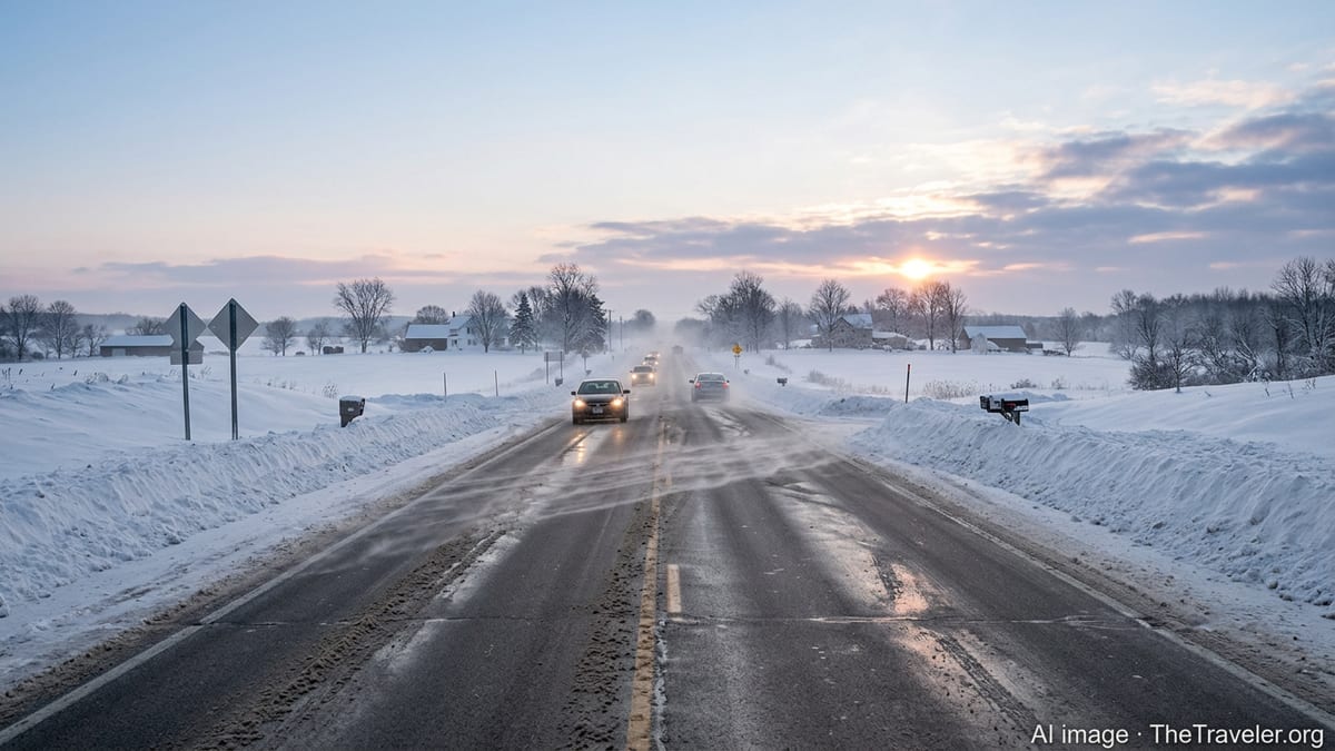
The snowstorm, part of a broader late-season system impacting portions of the Great Lakes region, moved across Livingston County from late Sunday into early Monday, dropping several inches of dense, wind-driven snow. Publicly available information shows that bands of heavy snowfall combined with falling temperatures turned main corridors and local roads icy within hours, creating treacherous travel for anyone still on the move.
Reports from regional media and transportation updates indicate that multiple slide-offs and minor collisions were recorded overnight, particularly on high-speed routes where visibility dropped quickly as squalls intensified. Motorists described stretches of roadway that appeared merely wet but were slick with a thin layer of compacted snow and ice, leading to sudden loss of traction.
As snowfall rates decreased toward daybreak and plows were able to make multiple passes, conditions gradually improved. By mid-morning, agencies monitoring surface conditions reported that primary highways were largely passable at reduced speeds, while secondary roads remained partially snow covered and rutted but no longer impassable in most areas.
In light of these improving conditions, the countywide travel advisory that had urged residents to limit driving to essential trips was lifted, signaling a shift from emergency response back to routine winter operations even as cleanup continues.
Overnight Crashes Underscore Storm’s Swift Intensity
Though snowfall totals in many communities ended within the range of a typical winter event, the timing and character of the storm played an outsized role in its impact. Snow arrived during the evening and intensified overnight, coinciding with temperatures falling below freezing. This produced a rapid transition from wet pavement to ice-glazed surfaces, catching some late travelers off guard.
According to published coverage from local news outlets, first responders and tow services were dispatched repeatedly to assist stranded vehicles, jackknifed trucks and fender benders on both county roads and nearby interstate segments. In several instances, traffic slowed to a crawl as vehicles navigated around disabled cars or waited for plows to reopen narrowed lanes.
Transportation summaries from the region describe a pattern familiar to long-time residents: even with pre-treatment on major routes, bursts of heavy snow and gusty winds quickly obscured lane markings and re-covered cleared pavement. Bridges, overpasses and shaded stretches were among the first to ice over, contributing to a cluster of incidents in those locations.
By early Monday, with sunrise revealing plow berms and spinout tracks along shoulders, motorists encountered evidence of the storm’s hazards even as driving conditions began to stabilize.
Travel Advisory Lifted as Cleanup and Commuting Resume
Once snow intensity decreased and reports indicated that plows were gaining the upper hand, county emergency and road management agencies shifted from broad travel warnings to more targeted cautions about lingering slick spots. The formal advisory, which had strongly discouraged nonessential travel overnight, was lifted after road condition assessments showed significant improvement.
Commuters returning to work found that primary corridors, including key east west and north south routes, were mostly clear but still slushy in places, with narrowed lanes and snowbanks at intersections. Publicly available traffic maps for the morning rush reflected slower-than-normal speeds but far fewer incident markers than during the height of the storm.
Transit and school operations also began to normalize, with many districts and services operating on regular or slightly delayed schedules rather than full closures. Parking lots, sidewalks and side streets lagged behind main roads in the cleanup process, prompting continued caution from local agencies about the risk of slips and falls as packed snow and ice remained on untreated surfaces.
Residents who had heeded earlier warnings to stay off the roads were able to use the improved conditions to run errands, check on relatives and clear driveways, contributing to a visible sense of relief as the community emerged from the intense but relatively short-lived disruption.
Persistent Winter Risks Despite Improving Weather
Even as the snowstorm moved out of the area, forecasters noted that winter hazards do not disappear as soon as flakes stop falling. Public forecast discussions for the region highlighted the potential for refreezing each night, particularly where slush, meltwater and compacted snow remain on surfaces and where drainage is poor.
Motorists are being reminded through public information channels that residual snowbanks can obscure sightlines at intersections and driveways, while rutted side streets can still cause vehicles to fishtail or bottom out. In rural parts of the county, wind can continue to blow powdery snow back across open stretches of road, producing patchy ice and diminishing visibility in localized bursts well after the main storm exits.
Emergency preparedness documents for Livingston County emphasize that traffic accidents on icy roads are among the most common and preventable winter storm impacts. These materials highlight the value of slowing down, increasing following distance and avoiding sudden braking or sharp turns when surfaces are only partially cleared, conditions that match many of the reports from this week’s storm.
With temperatures expected to fluctuate around the freezing mark in the coming days, residents are likely to experience a thaw freeze cycle that can quickly turn slush into black ice during the evening and early morning hours, extending travel challenges beyond the official end of the storm.
Community Response and Lessons for Late-Season Travel
The latest snowstorm served as a reminder that hazardous winter conditions can still arise abruptly late in the season, even as days grow longer and many residents begin to think ahead to spring travel. Social media updates, neighborhood message boards and local news comment sections reflected a mix of frustration with the sudden return of deep snow and appreciation for rapid plowing that kept main routes from remaining shut for long.
Publicly available information from recent county hazard planning reports points out that Livingston County’s mix of rural townships, small communities and commuter routes makes coordinated winter response especially important. The pattern seen in this storm, in which main highways became passable relatively quickly while residential and gravel roads lagged behind, aligns with longstanding priorities to keep emergency and commuter corridors open first.
For travelers, this event underscored the importance of checking updated forecasts, road condition reports and advisories before setting out, particularly during overnight hours when plow coverage may be thinner and deteriorating conditions can go unnoticed. Keeping vehicles fueled, packed with basic winter supplies and equipped with appropriate tires remains a key recommendation in regional preparedness guidance.
As Livingston County residents sweep away the last of the storm’s accumulation and watch plows widen lanes through tall roadside piles, attention is turning to the next round of changing weather. The swift lifting of the travel advisory offers cautious optimism that, for now, the worst of this particular winter blast is over, even as the season continues to demand respect from those who live, work and travel across the county.