
More news on this day
Macau is preparing for another high-impact storm year in 2026, with regional forecasts indicating up to eight tropical cyclones could affect the city as shifting El Niño conditions, intense rainfall and the potential for stronger typhoons heighten concern across the Pearl River Delta.
Get the latest news straight to your inbox!
Forecast Signals Busier-Than-Normal Typhoon Exposure
Recent seasonal outlooks for the western North Pacific point to an active tropical cyclone environment in 2026, with several climate indicators suggesting that Macau could again face a higher-than-average number of storms passing within striking distance. Regional media and government yearbooks have already documented a steady rise in storm frequency around the territory, with 2023 and 2025 both marking years of frequent tropical cyclone influence over the city.
Publicly available information from Macau-focused outlets reports that in 2025 the city was affected by a record 14 tropical storms and typhoons, the highest tally since local records began in the late 1960s. That experience, combined with an official forecast for 5 to 8 tropical cyclones affecting Macau in 2025, has set expectations that a similar range of 5 to 8 systems is plausible again for 2026 under comparable large-scale climate patterns.
Seasonal outlooks produced for the broader western North Pacific indicate that tropical cyclone activity is likely to be near or slightly above the long-term average, with several studies highlighting a tendency for storms to track closer to East and Southeast Asian coastlines during years of rapid shifts in Pacific sea-surface temperatures. For densely built, low-lying Macau, even a modest increase in the number of landfalling or near-miss storms can translate into significant coastal flooding and disruption.
While exact storm counts cannot be pinned down this early in the year, the combination of regional projections and Macau’s recent track record has prompted local planners, businesses and the tourism sector to treat 2026 as another year of elevated tropical cyclone risk, particularly from mid-summer through late autumn when typhoon activity typically peaks in the South China Sea.
El Niño Transition and a Volatile Climate Backdrop
Macau’s 2026 outlook is unfolding against a complex El Niño–Southern Oscillation backdrop. Climate agencies tracking conditions in the equatorial Pacific describe a transition away from La Niña toward neutral or warming sea-surface temperatures during 2026, with some forecasts pointing to the possible emergence of El Niño later in the year. Such transitions are known to reshape wind patterns and ocean heat content across the western North Pacific, where most of Macau’s typhoons are born.
Research cited by international climate centers highlights that even when ENSO is classified as neutral, subsurface heat anomalies and shifting jet stream patterns can fuel periods of intense tropical cyclone formation. A recent NOAA update notes significant subsurface warming across parts of the equatorial Pacific, a signal that can precondition the basin for more vigorous storm development once the seasonal monsoon circulation strengthens.
Scientific studies focused on the South China Sea and nearby waters also underline the importance of regional ocean heat content. One recent analysis of subsurface temperature patterns in the South China Sea shows how warm anomalies in the northern part of the basin can enhance the energy available to passing cyclones, supporting stronger winds and heavier rainfall as systems approach coastal hubs such as Macau, Hong Kong and the Guangdong coastline.
For 2026, these background signals add up to a picture of heightened uncertainty rather than guaranteed extremes. Nevertheless, the alignment of warm ocean conditions, a possible El Niño shift and persistent global temperature records suggests that any storms which do form have more fuel to draw upon, raising the prospect of rapid intensification events and short-notice upgrades that challenge existing warning and preparedness systems.
Extreme Rainfall and Urban Flooding Risks Under Scrutiny
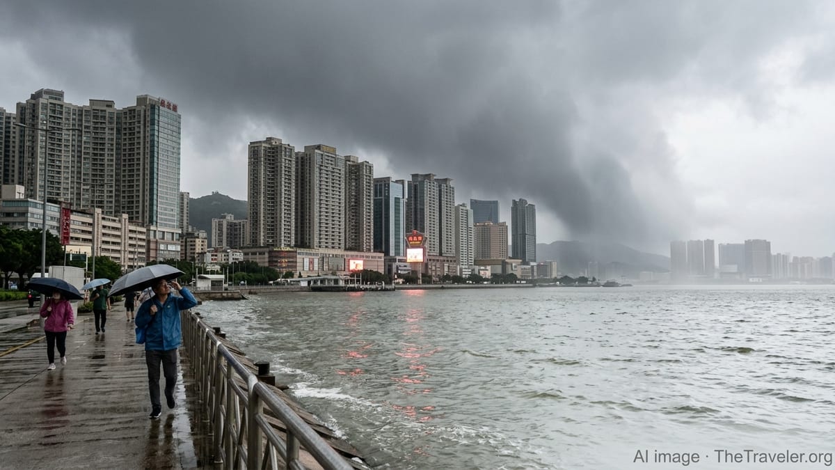
Beyond wind damage, the most pressing concern for Macau’s compact urban core is extreme rainfall. Recent summaries of the city’s climate by official yearbooks describe higher-than-normal average temperatures and humidity in 2023, alongside multiple episodes of heavy rain that triggered landslip alerts and serious street flooding. Coverage of 2025 highlights a similar pattern, with record storm counts often accompanied by cloudbursts that overwhelmed drainage networks.
These experiences reflect a broader regional trend identified by meteorological organizations and insurance-sector reports, which note that tropical cyclones in the western North Pacific are increasingly associated with high rainfall totals, slower forward speeds and lingering moisture plumes. When storms approach the Pearl River Delta, their spiral bands can stall over the same area for hours, delivering rainfall intensities well beyond the design thresholds of older stormwater infrastructure.
In low-lying parts of the Inner Harbour and along reclaimed waterfront districts, such extremes raise the risk of compound flooding, where heavy rain coincides with storm surge and astronomical high tides. Historical accounts of past typhoons in Macau, including severe events in 2017 and more recent systems in 2025, show how quickly underpasses, basements and ground-floor shops can fill with water once tide levels exceed critical thresholds.
Urban planners and engineers are therefore watching the 2026 outlook closely, as another season with up to eight tropical cyclones brushing the region would provide a rigorous real-world test of ongoing flood-mitigation projects. These include upgrades to pumping stations, sea walls, underground storage capacity and smart warning systems intended to give residents and visitors more time to move vehicles, secure property and avoid the most vulnerable zones during peak rainfall.
Typhoon Intensity Trends Raise Safety and Tourism Concerns
Alongside the sheer number of storms, their potential intensity is an emerging focus for Macau in 2026. Reports from the World Meteorological Organization’s Typhoon Committee, which convened in Macau in late 2025, emphasize the growing complexity of the regional storm climate, noting particularly strong systems such as Super Typhoon Ragasa in 2025 as examples of the destructive power that can accompany today’s warm oceans.
Seasonal prediction documents prepared for the western North Pacific in 2025, and used as a reference point for 2026 planning, point to a continued likelihood of severe typhoons forming over waters east of the Philippines before curving toward the South China Sea and East Asia. As global temperatures rise, several peer-reviewed studies suggest that while the total number of storms each year may not dramatically increase, the proportion reaching higher intensity categories is likely to grow.
For Macau’s economy, which relies heavily on tourism, gaming and large-scale entertainment venues, this trend has clear implications. Periods of elevated typhoon threat can prompt flight cancellations, temporary border slowdowns and the suspension of ferry services from Hong Kong and mainland ports, eroding visitor numbers during what would otherwise be peak travel weeks. Hotels and integrated resorts are already accustomed to activating contingency plans when signals are raised, but a future with more very strong storms could see more frequent and longer-lasting interruptions.
Publicly available information on recent typhoon seasons shows that signal upgrades to higher warning levels now occur several times most years, often accompanied by temporary closures of bridges, suspension of light rail segments and pre-emptive shutdowns at construction sites. If 2026 does indeed bring multiple strong typhoons close to the city, authorities responsible for infrastructure and emergency coordination may need to refine protocols to balance public safety with the desire to keep the tourism economy moving where conditions allow.
Preparedness, Regional Cooperation and Traveler Awareness
As Macau looks ahead to a potentially busy 2026 cyclone season, disaster risk management strategies are increasingly framed in regional and international terms. The Typhoon Committee meetings in Macau, coordinated by United Nations and World Meteorological Organization partners, have stressed how experience-sharing, common data platforms and joint training help coastal cities across East and Southeast Asia improve their forecasting, communication and response capabilities.
Macau’s own approach, as reflected in tourism information materials and government yearbooks, centers on clear public messaging around the territory’s tiered tropical cyclone signal system, heavy-rain warnings and flood alerts. Publicly accessible guidance encourages residents and visitors to monitor official bulletins closely from June through October and adjust travel, commuting and outdoor activities when higher signals are in force.
For international travelers, the 2026 outlook means that trip planning to Macau, particularly in late summer, should incorporate a basic understanding of how typhoon signals work, what services typically pause at each level, and the likelihood that severe weather could extend stays or delay departures. Travel industry commentary suggests that flexible booking policies, comprehensive travel insurance and attention to seasonal weather patterns are becoming essential parts of visiting coastal hubs in the western North Pacific.
With forecasts pointing to as many as eight tropical cyclones potentially influencing Macau’s weather in 2026, the city’s experience over the past decade serves as both a warning and a guide. The combination of increasingly intense rainfall, the risk of strong typhoons and a changing El Niño backdrop places a premium on early preparation, resilient infrastructure and well-informed visitors as Macau braces for another challenging storm season.