
More news on this day
A powerful nor’easter is forecast to surge up the East Coast this weekend, placing Pennsylvania and New Jersey under the threat of heavy snow, intense winds and life-threatening travel disruptions from late Sunday, February 22, into Monday, February 23, with forecasters warning of whiteout conditions, widespread road hazards and the potential for major impacts to one of the nation’s busiest travel corridors.
High-Impact Winter Storm Targets Densely Populated Corridor
Forecast models and official bulletins from the National Weather Service indicate that a rapidly strengthening coastal storm will organize off the Mid-Atlantic shoreline on Sunday before curving northward, drawing cold air over Pennsylvania and New Jersey and setting the stage for a classic nor’easter. Meteorologists say confidence is high that the system will produce a broad swath of heavy, wet snow across both states, with the heaviest bands likely to fall Sunday night into early Monday morning when many residents would normally be preparing for the workweek.
From the Lehigh Valley and the Philadelphia metro area to Trenton, Atlantic City and the Jersey Shore, tens of millions of people lie in the potential impact zone. Winter Storm Watches now cover nearly all of New Jersey and large portions of eastern Pennsylvania, signaling the risk for more than 6 inches of snow in many locations, combined with strong winds that could render travel not just difficult but dangerous during peak intensity.
While exact snowfall totals will depend on the storm’s final track, forecasters are increasingly concerned that this will be the most disruptive winter weather event since last month’s deadly multiday storm that buried parts of the East Coast. The key difference this time is the high probability that heavy snow will coincide with critical commuting hours and weekend return travel, compounding the risk of gridlock and accidents on already congested highways.
Heavy Snowfall Projections Raise Alarm in Pennsylvania
Across eastern Pennsylvania, particularly along and southeast of the Interstate 78 and Interstate 80 corridors, meteorologists anticipate a long-duration period of moderate to heavy snow from Sunday afternoon through Monday morning. Current projections suggest widespread accumulations in the 4 to 8 inch range, with localized higher totals where intense snow bands set up. In and around Philadelphia, some forecasts now suggest the potential for close to a foot of heavy, wet snow if the storm hugs the coast and deepens quickly.
Communities in the Lehigh Valley, the northern and western suburbs of Philadelphia and parts of central and northeastern Pennsylvania are expected to see plowable snow that could quickly cover untreated roads. Even areas that start as rain or a mix during the day on Sunday are expected to see a changeover to all snow as colder air filters in behind the strengthening low-pressure system. Once that transition occurs, snowfall rates could increase sharply, with visibility dropping in a matter of minutes.
Officials and forecasters warn that timing will be critical. The heaviest snow in Pennsylvania is expected late Sunday night through daybreak Monday, a window that includes both overnight travel and early morning commutes. Drivers who attempt to be on the roads during this period may encounter rapidly deteriorating conditions, with snow-packed surfaces, drifting, and limited sight distances. Transportation agencies are urging residents to complete essential travel early Sunday, then avoid nonessential driving until plowing and treatment can make progress later on Monday.
New Jersey Braces for Blizzard-Like Conditions and Coastal Impacts
In New Jersey, the storm’s track just offshore raises the stakes further. Winter Storm Watches blanket the state from Sussex and Warren counties in the north to Cape May and Atlantic counties at the southern tip. Current guidance from the National Weather Service’s Mount Holly office points to the potential for more than 6 inches of snow in many communities, with some coastal and southern areas at risk for even higher totals if heavy bands pivot inland and remain nearly stationary for several hours.
Along the Jersey Shore and across South Jersey, forecasters are monitoring the possibility of blizzard-like conditions as strong northeasterly winds develop in tandem with the deepening low. Gusts could reach 35 miles per hour or higher, especially late Sunday night into Monday, producing blowing and drifting snow that may reduce visibility to near zero at times. In a few coastal counties, meteorologists caution that official blizzard criteria could be met for a period if heavy snow and high winds persist together long enough.
The coastal orientation of the storm also heightens the risk of minor to locally moderate coastal flooding during times of high tide. Persistent onshore flow could send water levels rising in back bays and along barrier islands, threatening low-lying roads and properties that are especially vulnerable during winter storms. Local emergency managers are advising residents in flood-prone neighborhoods to stay alert for tidal forecasts and to move vehicles and valuables to higher ground in advance of the storm’s arrival.
Travel Disruptions Expected Across Roads, Rails and Airports
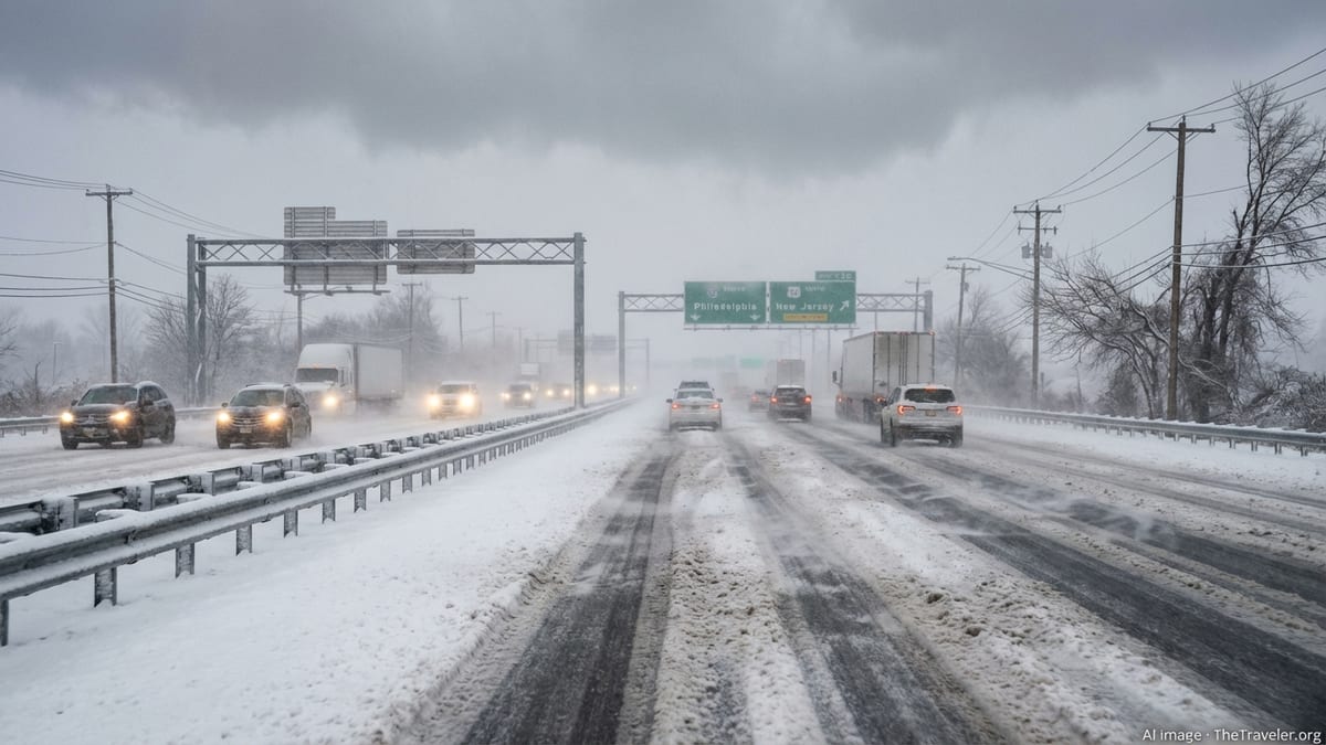
With the storm targeting one of the busiest transportation corridors in the United States, the potential for widespread disruptions is significant. The Interstate 95 spine from Baltimore and Philadelphia through Trenton and into the New York City metro area is likely to experience periods of snow-covered roadways, reduced speed limits and possible closures of key ramps or bridges as conditions worsen. State transportation departments in both Pennsylvania and New Jersey have already begun pre-treating major routes and mobilizing plow crews in anticipation of prolonged operations.
Air travel will almost certainly feel the impact. Philadelphia International Airport, Newark Liberty International Airport and smaller regional hubs in Allentown, Atlantic City and Trenton are all within the storm’s projected snow shield. Airlines frequently consolidate or cancel flights ahead of major winter events to avoid stranding aircraft and crews, and passengers with weekend or Monday morning itineraries are being urged to check with carriers frequently, consider rebooking to earlier flights and pack for extended delays if they must fly.
Rail and transit systems are also preparing for significant challenges. In past nor’easters, heavy, wet snow combined with gusty winds has led to downed branches and power lines along rail corridors, causing signal problems and service suspensions. Commuter lines that feed into Philadelphia and New York may operate on modified schedules or suspend certain routes if snow and ice begin to affect switches and overhead wires. Commuters are being advised to monitor alerts from agencies throughout Sunday and to build extra time into any essential Monday travel plans.
Life-Threatening Hazards: Whiteouts, Power Outages and Cold
Beyond disruptive travel, forecasters stress that the storm carries genuinely life-threatening hazards, particularly for those caught outdoors or on the roads during peak intensity. Periods of whiteout conditions are possible where strong winds coincide with the heaviest snowfall, especially in open areas, elevated stretches of highway and coastal communities. In these situations, visibility can drop to a few feet, disorienting drivers and making it nearly impossible to stay in lanes or see stalled vehicles ahead.
The combination of wet, heavy snow and gusty winds raises the risk of power outages as branches snap and trees topple onto power lines. Utilities across Pennsylvania and New Jersey are staging crews and equipment in advance, but ice and deep drifts may slow response efforts in hard-hit neighborhoods. Residents who rely on electrically powered medical equipment or home heating systems are being urged to secure backup plans, including fully charged batteries, alternative shelter options or generator access where safe and permitted.
Behind the storm, a surge of colder air is forecast to move into the region, locking in snowpack and keeping any residual slush frozen on untreated surfaces. Wind chills may dip well below freezing for an extended period on Monday and into Tuesday, heightening the risk of hypothermia for anyone stranded outside or working prolonged shifts in the elements. Emergency officials recommend that anyone who must travel carry a fully stocked winter safety kit, including warm clothing, blankets, food and water, a shovel and traction materials, and a charged mobile phone.
Officials Urge Residents to Prepare and Rethink Weekend Plans
As forecast confidence grows, state and local authorities in both Pennsylvania and New Jersey are urging residents to use the remaining hours of relatively calm weather on Saturday to prepare. That includes refilling prescriptions, topping off vehicle fuel tanks, purchasing basic groceries and ensuring that flashlights, batteries and portable chargers are in working order. In some communities, emergency management offices are coordinating with shelters and warming centers that can be activated quickly if prolonged outages or dangerous temperatures materialize.
Public safety officials are also asking residents to rethink nonessential weekend travel, particularly late Sunday afternoon and evening as snow intensifies. Those planning to return from ski trips, college visits or weekend getaways have been advised to travel earlier on Sunday or delay until after road crews have had a chance to clear primary routes on Monday. Authorities caution that even experienced winter drivers can be caught off guard by sudden whiteouts, hidden ice patches and snowdrifts that obscure lane markings.
Local governments are expected to deploy parking restrictions on snow emergency routes in many cities and suburbs, allowing plows to operate more efficiently. Residents are being encouraged to monitor municipal announcements for updates on designated snow routes, trash and recycling schedule changes, and any early decisions regarding Monday government operations or public meetings that might be postponed.
Schools, Businesses and Events Eye Potential Closures
With the worst of the storm’s impacts lining up with the start of the school and workweek, education officials and employers across Pennsylvania and New Jersey are watching the forecast closely. Many school districts already operate under protocols that trigger delays or closures when snowfall reaches specific thresholds or when buses cannot safely navigate secondary roads. If overnight snow totals on Sunday reach the upper end of current forecasts, widespread delays and remote-learning days are likely on Monday, especially in suburban and rural areas where plowing smaller roads can take longer.
Businesses that rely on in-person staffing, from manufacturing plants and warehouses to retail shops and restaurants, face difficult decisions about opening hours and employee safety. Some companies have indicated they may shift to remote work where possible for Monday, while others plan to operate on reduced schedules if conditions allow. Hospitality and tourism businesses in cities like Philadelphia and Atlantic City, which often see weekend visitors, are preparing for cancellations and no-shows as travelers opt to stay home or reschedule.
Sports events, concerts and community gatherings scheduled for Sunday evening and Monday are also at risk. Organizers are monitoring conditions and may announce postponements or moves to virtual formats to avoid forcing attendees onto treacherous roads. Residents with tickets to large events are encouraged to watch for official updates and to avoid secondary ticket or unofficial information that may be incomplete or inaccurate.
Storm Timing and What Residents Should Watch Next
While the overall setup for a high-impact winter storm is increasingly clear, forecasters emphasize that subtle shifts in the storm’s track and intensity will determine which communities see the greatest impacts. A track closer to the coastline would draw in more Atlantic moisture, boosting snowfall totals in New Jersey and southeastern Pennsylvania and expanding the zone of strong onshore winds and coastal flooding. A more offshore path, on the other hand, could limit snow amounts near the coast but still deliver a significant event inland.
The general timeline for the storm begins with increasing clouds and light precipitation developing Sunday morning, with a rain and snow mix in some areas before a transition to all snow later in the day as colder air deepens. The most hazardous period is expected from Sunday evening through early Monday morning, when heavy snow bands and strong winds combine to create the greatest risk for whiteouts and rapid accumulations. Snow should taper from southwest to northeast during the day Monday, though lingering flurries and blowing snow may continue to reduce visibility and keep roads slick.
Residents across Pennsylvania and New Jersey are being urged to pay close attention to updated statements and potential upgrades from Winter Storm Watches to Warnings or, in coastal areas, Blizzard Warnings as confidence in the storm’s exact behavior grows. By late Saturday and early Sunday, more precise snowfall maps and timing graphics from official forecast offices and trusted local meteorologists will help households and businesses make final decisions about travel, operations and contingency plans as the powerful winter storm bears down on the region.