
More news on this day
Massachusetts was on edge Saturday as forecasters warned that a powerful blizzard bearing down on the region could bring life-threatening whiteout conditions, coastal flooding, power outages and travel chaos from Sunday night through at least Tuesday morning.
Blizzard Warnings Blanket Eastern Massachusetts
A Blizzard Warning was in effect across much of eastern Massachusetts on Saturday, with meteorologists forecasting between one and two feet of snow for many communities from the New Hampshire border to Cape Cod. The National Weather Service said the storm would intensify rapidly off the mid-Atlantic coast on Sunday before curling toward New England, lashing the state with heavy bands of snow and punishing winds.
Forecasters warned that snowfall rates could exceed two inches per hour at the height of the storm, quickly overwhelming plows and making most roads impassable. With winds expected to gust as high as 60 miles per hour along the coastline and in exposed inland areas, blowing and drifting snow will reduce visibility to near zero at times, creating true blizzard conditions.
Officials emphasized that the most dangerous period appears to be late Sunday night through Monday evening, when the combination of heavy snow, strong winds and bitter wind chills will make any nonessential travel hazardous. The worst impacts are expected along the Boston to Providence corridor and across coastal communities from the North Shore to Cape Cod and the Islands.
Meteorologists also stressed that the storm’s track and intensity could still shift slightly, but the consensus points toward a high-impact event for nearly the entire eastern half of the state. Central and western Massachusetts will likely see significant snow as well, though winds there may be marginally less severe.
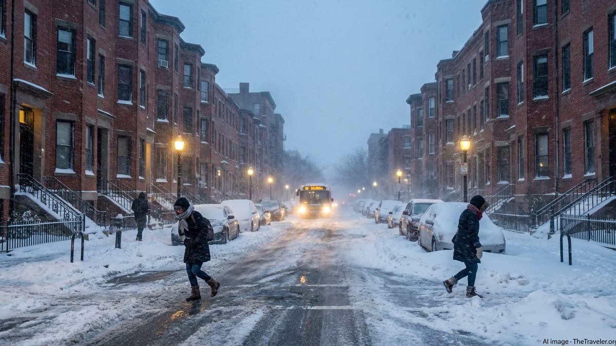
Travel Disruptions and Highway Closures Anticipated
Transportation officials spent Saturday preparing for what they described as a prolonged and dangerous winter weather event, urging residents to complete all nonessential travel before Sunday afternoon. State highway crews were pre-positioning hundreds of plows and salt trucks along major interstates, including I‑90, I‑93, I‑95 and Route 3, in anticipation of rapidly deteriorating conditions.
Authorities signaled that partial or full closures of key highway segments are possible if whiteout conditions make it impossible to keep lanes safely passable. Drivers were cautioned that stranded vehicles could quickly become a serious safety issue as visibility drops, winds strengthen and wind chills plunge well below freezing.
At Logan International Airport in Boston, airlines began issuing travel alerts and waiving change fees as they prepared to trim flight schedules. Widespread delays and cancellations are expected from late Sunday through Monday, with ripple effects likely across the national air network as aircraft and crews become out of position.
Commuter rail, subway and bus services were also bracing for widespread disruption. While transit agencies planned to run at least limited service during the storm, they warned customers to expect reduced frequency, weather-related delays, and possible line suspensions if snow piles up on tracks or power lines are damaged.
Power Outage Fears as Heavy Snow Meets Strong Winds
With a forecast calling for wet, heavy snow combined with wind gusts approaching hurricane force along exposed stretches of coast, utilities across Massachusetts warned of the high potential for scattered to widespread power outages. Tree limbs loaded with snow are likely to snap under the added weight, and strong winds could topple entire trees onto lines.
Utility crews were being staged around the state in advance of the storm, with companies bringing in mutual aid from neighboring states to help speed restoration efforts. Even so, officials cautioned that some customers in hard-hit or remote areas could be without electricity for an extended period, especially if access roads are blocked by drifts.
Emergency managers advised residents to charge phones and backup batteries, stock up on flashlight batteries, and avoid using candles due to fire risk. Households that rely on medical devices powered by electricity were urged to make contingency plans, including identifying shelters or relatives with backup generators in case of prolonged outages.
Authorities also warned about the risk of carbon monoxide poisoning as families turn to portable generators or improvised heating sources. Residents were reminded to keep generators well away from doors, windows and vents, and to ensure that carbon monoxide detectors are installed and functioning properly before the storm hits.
Coastal Communities Brace for Flooding and Beach Erosion
Along the Massachusetts shoreline, the incoming storm posed a dual threat of heavy snow and coastal flooding. While exact tide impacts will depend on the storm’s final track and timing, forecasters indicated that strong onshore winds and low pressure could drive water levels high enough to cause minor to moderate flooding in vulnerable coastal neighborhoods.
Communities on the North Shore, South Shore, Cape Cod and the Islands were watching the forecast closely for signs of worsening storm surge projections. Local officials discussed potential voluntary evacuations for residents in flood-prone areas, especially those with a history of basement flooding or road closures during prior nor’easters.
Beach erosion was another major concern as powerful waves generated by the storm bear down on already fragile dunes and seawalls. Coastal engineers warned that repeated battering from winter storms has left some protective structures weakened, raising the risk of damage to homes, roads and utilities that sit just inland.
Harbormasters up and down the coast advised boat owners to secure vessels, check moorings and remove loose items from docks and piers. With the combination of high winds, rough seas and potential ice, maritime travel and fishing operations are expected to be severely curtailed until conditions improve.
Cities and Towns Rush to Prepare Residents
City and town governments across Massachusetts moved quickly into storm-preparedness mode, activating emergency operations centers, coordinating with state agencies and issuing detailed guidance to residents. Many municipalities announced parking bans that will go into effect on Sunday afternoon or evening to allow plows to clear streets efficiently once snow begins to pile up.
Public works departments spent Saturday checking equipment, topping off fuel supplies and designating priority routes for plowing, including access to hospitals, fire stations and other critical facilities. Officials asked residents to keep fire hydrants and storm drains clear where possible, cautioning that deep snow and ice can obstruct emergency access and contribute to flooding when temperatures rise.
Some communities began preparing to open warming centers and emergency shelters for residents who may lose power or heat. School districts signaled that closures or a shift to remote learning on Monday were increasingly likely, with many planning to announce decisions by Sunday evening once the storm’s onset timing and intensity were clearer.
Local leaders used press conferences, alert systems and social media to press home a simple message: stay off the roads once conditions deteriorate, check on neighbors who may need assistance, and follow official instructions as the storm unfolds. Residents were urged not to assume this would be an ordinary winter snowfall, but rather a high-impact event requiring extra caution.
Grocery Lines, Gas Stations and Last-Minute Storm Prep
Across the state, residents flocked to grocery stores, pharmacies and gas stations in the hours leading up to the storm. Shelves of basics such as bread, milk, bottled water and batteries thinned quickly as people stocked up for what could be several days of limited travel and intermittent power.
Hardware stores reported brisk sales of snow shovels, ice melt, roof rakes and portable generators as homeowners rushed to address lingering winter maintenance and prepare for the possibility of heavy rooftop accumulations. Staff at local shops said they had been tracking the forecasts all week and increased orders of key storm-related items, but demand still exceeded expectations.
At gas stations, lines formed as drivers filled up vehicles, snow blowers and spare containers. Transportation officials recommended that motorists keep at least half a tank of fuel in their cars ahead of the storm in case they become stuck or detoured, and to ensure that heaters can run safely if delays occur on clogged roads.
Despite the anxious mood, there were also familiar scenes of neighborly cooperation. In many communities, residents organized informal efforts to check in on elderly neighbors, share extra supplies and coordinate snow clearing for those who may not be able to shovel or operate equipment on their own.
Tourism, Travel Plans and Winter Getaways Disrupted
The timing of the storm threatened to upend February travel plans for visitors and residents alike. Hotels in Boston and coastal resort towns reported a wave of cancellations from out-of-state guests who were scheduled to arrive on Sunday and Monday, with many opting to postpone trips rather than risk getting stranded.
Ski areas in western Massachusetts and neighboring New England states watched the forecast closely, weighing the benefits of fresh snow against the risks of hazardous travel for guests. While mountain resorts may ultimately benefit from deeper snowpack later in the week, operators acknowledged that driving conditions on access roads during the height of the blizzard could be treacherous.
For those already on vacation in Massachusetts, the storm prompted hasty schedule changes. Visitors scrambled to rebook flights and trains ahead of expected cancellations, while others resigned themselves to riding out the blizzard in hotels and short-term rentals, stocking up on food and preparing for a temporarily quieter, snowbound stay.
Local tourism officials said that while the immediate impact of the storm on revenue could be significant, major winter weather events sometimes draw visitors back later in the season, drawn by dramatic images of snow-covered city streets and coastal landscapes reshaped by the elements.
Safety Guidance and What Residents Should Expect Next
Emergency officials urged residents to treat the approaching blizzard as a serious threat, emphasizing simple but vital safety precautions. People were advised to stay indoors during the worst of the storm, avoid unnecessary driving, dress in layers if they must go outside, and limit time exposed to strong winds and cold temperatures.
Homeowners were reminded to clear snow from roofs, decks and exterior vents once conditions are safe, as heavy accumulation can lead to structural stress and blocked exhausts for furnaces, dryers and other appliances. Shoveling should be done carefully and in stages to reduce the risk of overexertion, particularly for older adults and those with heart conditions.
Officials said residents should prepare for the possibility that cleanup could take several days, especially on side streets and in rural areas where plows may not be able to make frequent passes. Even after the snow and wind subside, lingering drifts, icy patches and downed branches may continue to pose hazards.
As Massachusetts braces for the full impact of the storm, forecasters and emergency managers promised regular updates on snow totals, road conditions, power restoration and coastal impacts. Residents were encouraged to monitor trusted local news outlets and official alerts for the latest information as the powerful winter system moves through the region.