
More news on this day
Holidaymakers heading to Spain’s Canary Islands this week are being urged to brace for unusually powerful Atlantic swells, as a series of storm-driven “Atlantic surges” sends high waves crashing into popular beaches and resort promenades across the archipelago.
Get the latest news straight to your inbox!
Unseasonal Atlantic Swell Pounds Winter-Sun Hotspot
Publicly available meteorological information shows that a potent Atlantic system linked to the current European windstorm season is driving a long-period northwest swell toward the Canary Islands, coinciding with spring tides and onshore winds. The combination is producing rough seas, large breakers and dangerous rip currents around several of the archipelago’s best-known holiday coastlines.
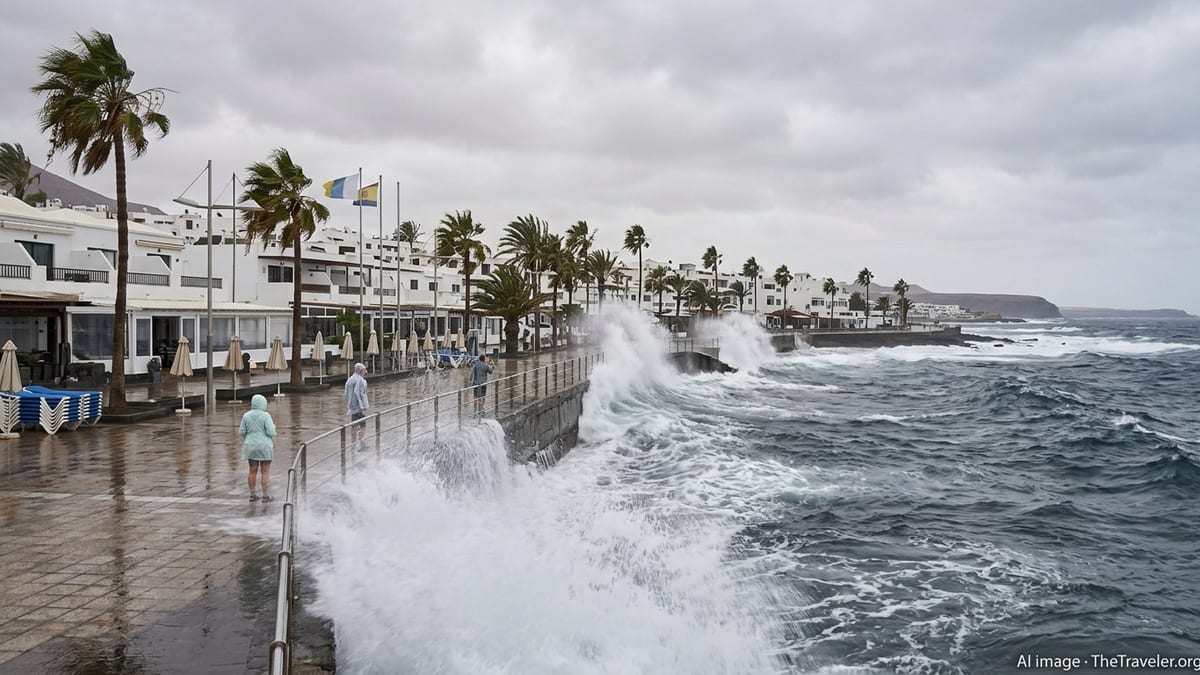
Forecast data from Spain’s state meteorological services indicates that exposed north and west coasts of islands such as Tenerife, Gran Canaria, Lanzarote and La Palma are likely to see waves well above normal for mid-March. In some areas, maximum wave heights of five to seven metres are being discussed in local coverage, particularly around Lanzarote and more open Atlantic stretches.
This pattern follows weeks of unsettled Atlantic weather across the wider region, with recent named storms already delivering heavy rain and disruptive winds to parts of mainland Spain and the Canary Islands. For visitors expecting placid winter-sun conditions, the current sea state may come as an unwelcome surprise just as the Easter getaway period begins to ramp up.
Meteorologists describe the phenomenon as an energetic northwest swell generated far out in the Atlantic, which can travel long distances with little loss of power. When it encounters the steep volcanic coastlines and shallow shelves of the Canary Islands, the energy is released in the form of powerful surf and sudden surges that can reach well above the usual tide line.
Alerts, Closures and Cancellations Across the Islands
Regional bulletins and local media reports indicate that coastal alerts remain in force for parts of the archipelago, with particular attention on waterfront areas where large waves are overtopping sea walls and flooding low-lying promenades. Authorities at island level have been activating emergency plans in recent days in response to a wider high-impact storm setup that includes heavy rain, strong winds and, at high elevations, snow.
On Tenerife, public information shared with participants of the high-profile Tenerife Bluetrail by UTMB trail-running event confirms that all races and outdoor activities linked to the competition have been cancelled. Organisers cite severe weather warnings issued by meteorological agencies and the need to keep emergency services free to respond to potential incidents during the stormy spell.
Elsewhere in the islands, individual municipalities are temporarily closing exposed coastal paths, natural rock pools and some beach access points where waves are breaking over normally safe areas. Coastal roads in known trouble spots are being monitored for overtopping and debris, and some bus routes and seafront car parks have been curtailed or restricted as a precaution.
Ferry operators on inter-island routes are also watching the forecasts closely, with potential schedule adjustments when conditions in harbour entrances become too hazardous for smaller vessels. While major ports are designed to withstand heavy Atlantic swell, prolonged rough seas can still slow operations and lead to delays that ripple through travel plans.
Impact on Tourists: From Beach Plans to Safety Risks
For visitors, the immediate impact of the Atlantic surge is most visible on the shoreline. Beaches on more sheltered southern coasts may remain open but show stronger than usual shore break, while northern and western stretches familiar to surfers are seeing powerful, often messy waves that are far beyond the comfort zone of casual swimmers.
Travel forums and social media posts from the islands in recent days highlight cancelled excursions, closed natural swimming pools and disappointment among families who had planned boat trips or paddleboard outings. In some resort areas, red flags are flying on beaches that are normally considered calm at this time of year, with lifeguards discouraging even experienced swimmers from entering the water.
Safety advisories circulated through local media are urging residents and tourists alike to avoid walking on breakwaters, harbour walls or low-lying seafront promenades when the swell is peaking. Sudden larger sets, sometimes referred to as rogue or sneaker waves, can sweep over these structures with little warning, knocking people off their feet and pulling them into turbulent water.
Indoor attractions, hiking at lower elevations and urban sightseeing are emerging as popular fallback options for those whose sun-and-sea plans have been upended. Hotels and tour operators are encouraging guests to check the latest local advice each morning, as conditions can vary sharply between the windward and leeward sides of the same island.
Why This Atlantic Surge Matters for Future Holidays
Climate and ocean researchers have been examining how changing storm tracks and a warming Atlantic may influence wave patterns around the Canary Islands and other eastern Atlantic coasts. Recent scientific work on regional storm surge and wave climate suggests that, while year-to-year variability remains high, the frequency of intense swell events affecting the archipelago could increase over coming decades.
Projections for the North Atlantic and adjacent basins point to a modest rise in average sea level combined with possible shifts in the strength and direction of winter storm systems. Even a relatively small change in baseline sea level can amplify the impact of high surf during spring tides, allowing waves to reach further inland across beaches and seafront infrastructure.
For tourism planners and local authorities, this raises questions about the resilience of promenades, beachfront hotels and vital coastal roads that underpin the islands’ year-round visitor economy. Some municipalities are already experimenting with more flexible, nature-based defences such as restored dunes and wider beach profiles that can absorb wave energy and reduce the reach of extreme surges.
Travel businesses are also beginning to factor more volatile winter and early-spring conditions into their planning, with a greater emphasis on weather contingencies and alternative experiences away from the shoreline. For visitors, that may eventually translate into clearer seasonal messaging about the small but real risk of high-impact Atlantic swell affecting short stays.
What Travellers Should Know If They Are Booked to Go
For those with imminent departures to the Canary Islands, airlines and airports are currently operating broadly as normal, according to publicly available travel updates. The primary disruption risk lies not in getting to the islands but in what awaits along the seafront once there, particularly during peak swell periods.
Travel industry guidance suggests that holidaymakers monitor island-level alerts in the days before arrival and pay close attention to beach flag systems and local notices once on the ground. Conditions can improve or deteriorate quickly as individual storm systems move through, and sheltered resorts may experience far milder effects than dramatic footage from more exposed headlands might suggest.
Comprehensive travel insurance that covers weather-related disruption to excursions and activities can help soften the financial blow if boat trips, outdoor events or adventure sports are cancelled at short notice. Visitors are also being encouraged to stay in close contact with their tour operator or accommodation provider for the latest practical information.
Despite the eye-catching images of huge waves and flooded promenades circulating in European media, inland resort areas, cultural sights and much of the islands’ hospitality sector remain open and functioning. For now, the main message from local coverage is one of caution at the coast rather than calls to stay away, as the Canary Islands ride out yet another powerful Atlantic surge.