
More news on this day
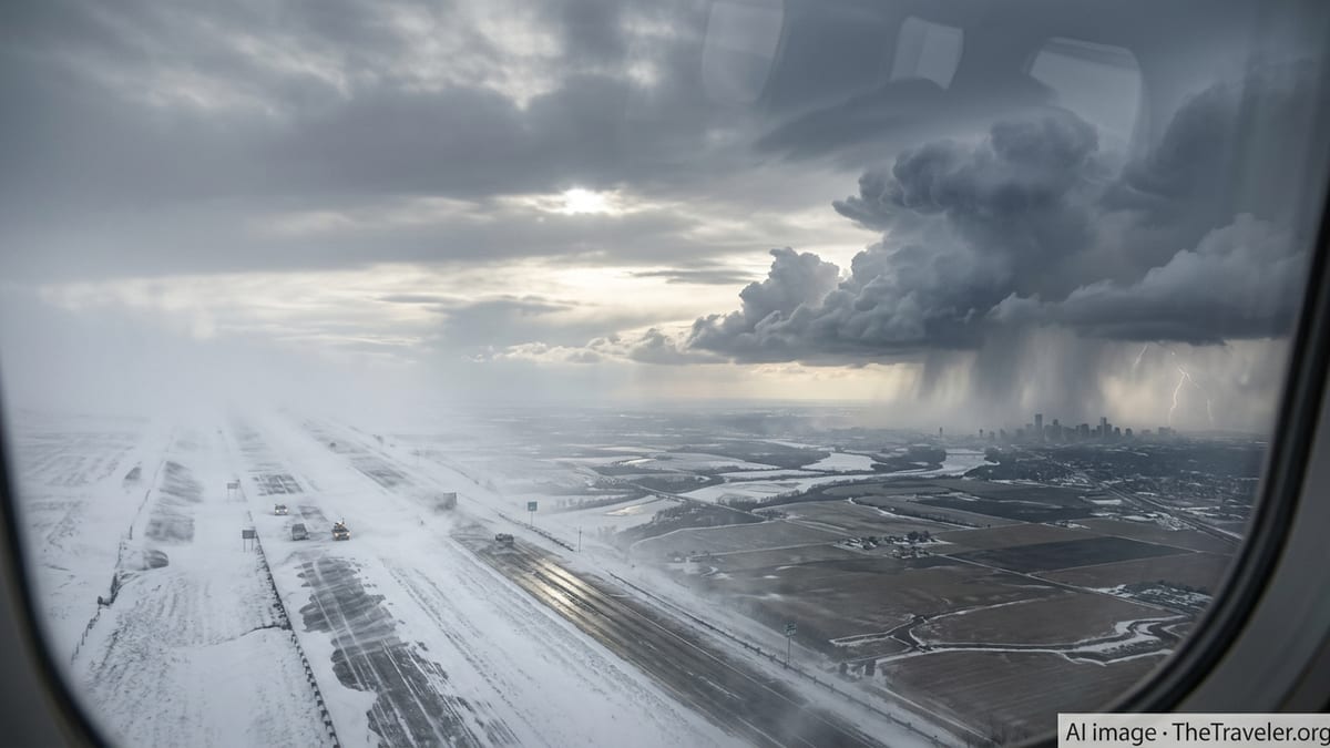
A sprawling March 2026 storm system is unleashing blizzard conditions, dangerous ice and rounds of severe thunderstorms across central and eastern United States, raising the risk of widespread travel disruption just as one of the most volatile winter seasons in recent years continues.
Get the latest news straight to your inbox!
Historic Winter Season Sets the Stage
The latest storm arrives on the heels of a punishing stretch of winter weather that has repeatedly tested transport networks across the country since January 2026. A series of major systems, including a late-January cross-country winter storm and an early February bomb cyclone, have already produced crippling snow, ice and wind from Texas to New England, triggering thousands of flight cancellations and long-lasting power outages.
Publicly available summaries from recent events show that January’s expansive winter storm brought disruptive wintry precipitation from northern Mexico through the southern and northeastern United States, with airlines scrapping more than ten thousand flights on one of the worst single days for cancellations since early 2020. Separate coverage of the February blizzard, widely referred to as the Blizzard of 2026, describes feet of snow, hurricane-force wind gusts and formal travel bans in parts of the Mid-Atlantic and Northeast.
Against that backdrop, the March storm is being watched closely by travelers, airlines and ground transport operators. Forecast discussions highlight the unusual overlap of hazards expected in mid-March: a deep winter storm over the northern tier, a strong cold outbreak over the Midwest and East, and an energetic clash with warmer, humid air to the south capable of producing widespread severe thunderstorms.
Meteorological outlooks indicate that the atmosphere over North America this week is primed for what some forecasters describe as "weather whiplash," with rapid shifts from unseasonable warmth to driving snow, and from quiet conditions to rapidly intensifying low-pressure systems. For those planning trips across central and eastern states, that volatility increases the risk of sudden, hard-to-predict disruptions.
Blizzard Conditions Target Upper Midwest and Great Lakes
The winter side of the storm is expected to hit hardest across parts of the Upper Midwest and Great Lakes, where blizzard warnings and winter storm alerts cover wide areas including portions of the Dakotas, Minnesota, Wisconsin and northern Michigan. Forecast guidance points to a band of heavy snow capable of bringing accumulations measured in feet, accompanied by strong, gusty winds and sharply falling temperatures.
Regional media in states such as Minnesota and Wisconsin are already describing the system as a major March snowstorm, with residents sharing reports of deteriorating conditions, near-zero visibility and fast-building snowdrifts on key interstates and secondary highways. Advisories circulating on social platforms urge drivers to avoid nonessential travel during the height of the storm, citing a growing number of slide-offs and collisions as surfaces turn icy and whiteout conditions develop.
Blizzard criteria in these areas typically involve sustained winds or frequent gusts of at least 35 miles per hour combined with heavy blowing snow that reduces visibility to less than a quarter of a mile for several hours. Forecast briefings for this event suggest that many communities in the northern tier could meet or exceed those thresholds, especially in open country and along east-west highway corridors where crosswinds are strongest.
Rail and bus operators across the Upper Midwest are also preparing for potential impacts. Prior severe winter events this season have already shown how drifting snow and bitter wind chills can slow freight movements, delay passenger services and complicate last-mile deliveries, with knock-on effects for supply chains that depend on just-in-time logistics.
Severe Thunderstorms and Tornado Risk in the South and East
South of the primary snow band, the same storm system is expected to tap warm, moisture-rich air from the Gulf of Mexico, fueling a separate corridor of hazardous weather stretching from the southern Plains through the Mississippi Valley and into parts of the Mid-Atlantic and Southeast. Outlooks from national forecast centers highlight an enhanced risk of severe thunderstorms, with potential for damaging straight-line winds, large hail and a few tornadoes.
Recent multi-day severe weather episodes earlier in March brought numerous tornado and hail reports across Oklahoma, Kansas and neighboring states, demonstrating how quickly storms can intensify when strong upper-level dynamics and rich low-level moisture align. Discussion threads based on Storm Prediction Center outlooks now point to a renewed threat of intense thunderstorms from the Carolinas northward toward southern Pennsylvania, particularly as the March 2026 storm drags a sharp cold front eastward.
For travelers in these regions, the hazards differ from the blizzard zone but can be just as disruptive. Short-notice severe storm outbreaks can temporarily close airports, force inbound flights to divert and shut down exposed stretches of interstate where high-profile vehicles are vulnerable to strong crosswinds. In urban areas, torrential rainfall may overwhelm drainage systems, leading to flash flooding that blocks underpasses and low-lying routes during peak travel times.
Publicly available guidance encourages motorists to monitor local radar and alerts closely on days when severe thunderstorms are forecast, and to build extra time into trips in case of sudden delays. Air passengers traveling through major hubs in the Southeast and Mid-Atlantic are being advised by airlines and travel services to check the status of connections frequently and consider earlier departures where flexibility allows.
Air Travel Braces for Another Wave of Disruptions
After a winter already marked by repeated bouts of mass cancellations, the airline sector is once again bracing for impact. During the January 23 to 27 winter storm, national tracking data showed more than eleven thousand flights canceled in a single day as snow and ice spread across multiple regions, snarling operations at major hubs and creating multi-day backlogs for carriers and passengers.
The February 22 to 23 blizzard in the Northeast produced a second wave of significant aviation disruption, with several thousand flights canceled or delayed as snow and high winds forced runway closures and reduced visibility below safe landing thresholds at airports from Washington to Boston. Coverage of the event pointed to widespread ground stops, extended de-icing operations and lengthy rebooking queues, especially at large coastal gateways that handle dense transatlantic and domestic traffic.
The March 2026 storm threatens to repeat that pattern on a broad scale. With heavy snow and wind in the Upper Midwest and Great Lakes, severe thunderstorms across the South and East, and a sharp temperature gradient slicing through central states, airlines face the challenge of keeping aircraft and crews appropriately positioned while preserving safety margins. Even airports physically outside the heaviest precipitation zones can experience knock-on disruptions as aircraft arrive late or are temporarily repositioned.
Travel industry analysis suggests that passengers with time-sensitive itineraries should treat this week as a period of elevated risk for significant delays. Flexible tickets, awareness of alternative routings and readiness to adjust plans on short notice may be especially valuable for those transiting hubs in the central and eastern United States.
What Travelers Across the Region Should Expect
For road travelers, the biggest concern will be rapidly changing conditions over relatively short distances. A drive that begins in cool rain can transition into freezing rain, heavy snow or even severe thunderstorms within a few hours as the storm’s frontal boundaries shift. Forecast maps for this system depict tight gradients between rain, mixed precipitation and snow, a setup that can catch unprepared drivers off guard.
Highway agencies are deploying plows, salt trucks and maintenance crews in anticipation of significant snow and ice accumulation in the northern and central states, while also warning of limited visibility and the possibility that some routes may become impassable during the peak of the storm. In blizzard-prone areas, prior events this season have demonstrated how quickly plowed roads can drift shut again when strong winds persist.
Rail passengers may also encounter delays as dispatchers reduce speeds through affected corridors to account for slick tracks, strong winds or fallen branches and debris. On some routes, operators may opt for preemptive schedule adjustments rather than risk mid-journey disruptions where access for rescue or repairs is difficult.
For travelers still intending to move across central and eastern states during the storm, publicly available emergency preparedness guidance recommends monitoring reliable local forecasts, packing winter survival supplies in vehicles, keeping mobile devices charged and informing family or colleagues of expected routes and arrival times. With one of the most active winter seasons in recent years still unfolding, situational awareness and flexibility remain key to navigating a complex and fast-changing weather landscape.