
More news on this day
A powerful late-season winter storm is slamming Minnesota and a broad swath of the Upper Midwest this weekend, with forecasters describing a high-impact blizzard that is already disrupting travel, cutting power to thousands and compounding weather-related flight chaos across the United States.
Get the latest news straight to your inbox!
Blizzard Warnings Stretch Across Minnesota and the Upper Midwest
Publicly available forecasts from the National Weather Service show a sprawling March 13 to 16 storm system driving heavy snow, high winds and blizzard conditions from the northern Rockies across the Dakotas into Minnesota, Iowa, Wisconsin and northern Michigan. Blizzard warnings and winter storm warnings cover much of central and southern Minnesota, including the Twin Cities corridor, as snow bands pivot across the region and winds intensify.
Meteorological summaries describe a deep low-pressure system tracking across the Plains and into the Great Lakes, pulling Arctic air south while tapping Gulf moisture. This combination is producing prolonged periods of moderate to heavy snow, with localized totals likely to exceed a foot in parts of Minnesota and neighboring states. In some communities, residents report drifts forming rapidly as wind-driven snow piles up against homes, vehicles and rural roads.
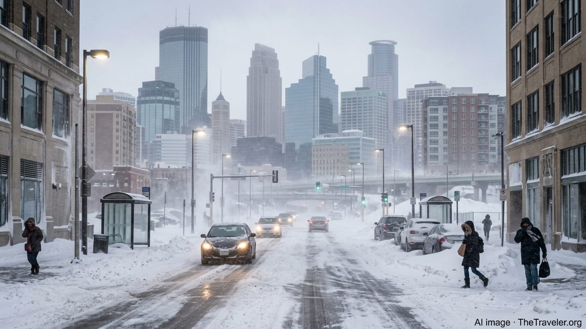
Reports from Duluth and other communities along Lake Superior indicate that blizzard conditions arrived Thursday night and continued into the weekend, with visibility frequently dropping to near zero in open areas. In central Minnesota, social media posts and local coverage describe a landscape turning uniformly white as afternoon light fades behind sweeping curtains of snow.
Although Minnesota is accustomed to harsh winter weather, early indications suggest this storm ranks among the most disruptive of the season. Ongoing updates from regional outlets highlight how quickly conditions can deteriorate, with many areas moving from light snow to full white-out within a few hours as wind speeds increase.
High Winds Drive White-Out Conditions and Power Outages
High wind warnings and advisories are in effect across large portions of the northern Plains and Upper Midwest, overlapping the heaviest snow bands. Forecast discussions point to wind gusts frequently topping 40 to 50 miles per hour in exposed areas of Minnesota, with locally stronger gusts along the Buffalo Ridge, open prairies and the North Shore of Lake Superior.
These winds are rapidly transforming falling and existing snow into ground blizzards, especially in rural areas where long stretches of open fields allow snow to be lofted and carried across roads. Drivers in southern and central Minnesota report sudden loss of visibility as passing squalls and wind gusts whip snow into the air, making it difficult to distinguish road surfaces, medians and ditches.
The same wind field is increasing the risk of power outages. Heavy, wet snow combined with strong gusts is weighing down tree branches and power lines in parts of Minnesota, the eastern Dakotas and western Wisconsin. Regional utilities are reporting scattered to widespread outages, particularly in wooded areas and around lake country where trees are more dense and susceptible to limb breaks.
Emergency managers and transport agencies are using public channels to urge residents to prepare for the possibility of extended outages, especially in rural communities where restoration can be slowed by drifting snow and blocked roads. Residents have been advised through public messaging to charge devices, stock basic supplies and avoid unnecessary travel while crews work to stabilize the grid.
Flight Cancellations Mount as the Storm Disrupts National Travel
The blizzard’s impact extends far beyond roadways. Data from aviation tracking services and airline status pages shows hundreds of flights canceled or delayed across the country as the storm sweeps east. Minneapolis–Saint Paul International Airport is a focal point of disruption, with airlines preemptively consolidating schedules ahead of the worst conditions to avoid aircraft and crew becoming stranded.
Travelers have reported widespread cancellations of evening and overnight departures from Minnesota, including international flights, as carriers factor not only local snowfall but also the risk of crosswinds and low visibility from blizzard-level gusts. In several cases, passengers describe learning of cancellations a day in advance, suggesting that airlines are relying heavily on forecast guidance to make early operational calls.
Because this storm follows a series of high-impact winter systems that already strained airline networks earlier in the season, ripple effects are spreading quickly. Flight-tracking dashboards show weather-related disruptions at major hubs across the Midwest and Northeast, where crews and aircraft are out of position and connecting itineraries are broken.
Travel experts monitoring the situation recommend that passengers departing or arriving anywhere in the northern tier of states check their airline apps frequently, anticipate rolling schedule changes and be prepared for last-minute gate shifts. For those whose flights are still scheduled to operate, extra transit time to and from airports is strongly advised due to hazardous road conditions around major hubs.
Dangerous Travel Conditions and Localized Emergency Responses
Across Minnesota and neighboring states, interstates, state highways and rural routes are becoming increasingly treacherous as snowfall and winds intensify. Publicly available traffic camera feeds show plows struggling to keep up with rapid accumulation, while sections of roadway periodically disappear behind volleys of blowing snow.
State transportation departments report multiple crashes and spinouts attributed to slick surfaces and sudden drops in visibility. Some stretches of highway are being restricted to essential travel only during peak blizzard periods, and localized closures are emerging where jackknifed trucks or pileups block lanes and plows cannot safely operate.
Local coverage from communities in central and southern Minnesota highlights how quickly routine errands can turn risky. Residents recount short drives to grocery stores or workplaces that became hazardous as conditions deteriorated mid-journey, emphasizing the difficulty of judging storm timing based on a window view alone.
Public alerts distributed through weather radios, mobile notifications and broadcaster cut-ins repeatedly stress that even experienced winter drivers can be caught off guard by white-out bursts. Officials are encouraging those who must travel to carry winter emergency kits, including warm clothing, blankets and basic supplies, in case they become stranded before help arrives.
What Travelers Need to Know in the Coming 24 to 48 Hours
Forecasters expect the core of the storm to continue affecting Minnesota and the Upper Midwest into Monday, March 16, before shifting its heaviest snow and wind impacts toward the Great Lakes and interior Northeast. However, lingering snow showers, blowing and drifting snow, and bitter wind chills are likely to persist behind the departing system.
For road travelers, the next 24 hours are expected to bring the greatest hazards across much of Minnesota. Transportation agencies recommend postponing nonessential trips until plows have had time to clear primary routes and winds ease. Those who must drive are urged to stick to main roads, share itineraries with friends or family and monitor updated maps and advisories before departure.
Air travelers should expect continued schedule volatility even after snowfall begins to taper. Airlines commonly require several cycles to reposition aircraft and crews after a major storm, and connecting passengers may face ongoing delays or missed links as the system’s impacts propagate eastward. Flexible rebooking options, alternate routings and extended layovers may help reduce stress as conditions evolve.
For residents and visitors across the affected region, the overarching message from public information channels is to stay informed and ready for rapid changes. This mid-March blizzard is demonstrating that winter is far from over in the Upper Midwest, and that even a region well-versed in snow can be tested when heavy precipitation, high winds and nationwide travel networks collide.