
More news on this day
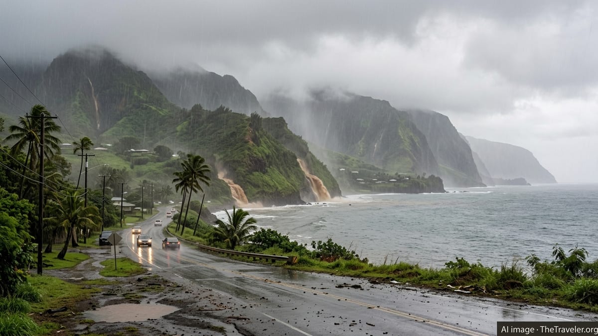
Torrential rains linked to a persistent Kona storm are hammering Molokaʻi and Lānaʻi, triggering flooding, infrastructure disruptions, and hazardous travel as a Flood Watch remains in effect for all Hawaiian islands through Sunday.
Get the latest news straight to your inbox!
Intense Kona Storm Triggers Island-by-Island Flood Alerts
Forecasts from the National Weather Service describe a slow-moving Kona low parked to the west of the state, drawing deep tropical moisture over the islands and producing repeated rounds of heavy showers and thunderstorms through the weekend. Recent outlooks indicate that Maui County, including Molokaʻi and Lānaʻi, is now among the areas most likely to see the heaviest rainfall and the most prolonged flooding concerns.
Weather discussions and publicly available briefings describe saturated ground from storms earlier in March combining with new downpours to heighten runoff, overwhelm drainage systems, and send streams rapidly over their banks. Hydrologic outlooks emphasize that even locations outside of the most intense rain bands can experience sudden flooding because soils across much of the state are already waterlogged.
Reports from local news outlets and community channels point to a complex setup involving multiple low pressure centers drifting northeast of the state. This pattern is expected to maintain unstable, moisture-rich air over Hawaiʻi through at least Sunday, with the potential for training showers that repeatedly pass over the same communities. As a result, forecasters have extended Flood Watch messaging statewide and continue to highlight the risk of flash flooding nearly anywhere heavy showers develop.
Molokaʻi and Lānaʻi Bear Brunt of Weekend Downpours
Within Maui County, recent forecast updates have shifted particular concern toward Molokaʻi and Lānaʻi, where model guidance suggests some of the most persistent rainfall totals could accumulate. Earlier storm cycles this month already dropped significant rain over windward and interior slopes; the new system is expected to add several more inches, especially on higher terrain that wrings additional moisture from passing bands.
Community reports circulating on visitor and resident forums describe localized road ponding, rapidly rising gulches, and intermittent power interruptions on Molokaʻi as squalls move through. On Lānaʻi, visitors are noting muddy backroads, reduced visibility in heavy rain bursts, and brief service disruptions, especially in higher elevation neighborhoods near Lānaʻi City.
Publicly available rainfall projections shared in recent days show potential totals on Molokaʻi and Lānaʻi rivaling or exceeding those seen in many parts of the state during the first March Kona storm. With each new round of showers, the risk increases for landslides on steep slopes, rockfall along coastal routes, and overflow of low-water crossings, particularly on less developed road networks that serve rural communities and resort areas.
Travel Disruptions, Brown Water, and Visitor Safety Concerns
Travel impacts are emerging as one of the most immediate concerns for both residents and visitors on Molokaʻi and Lānaʻi. According to publicly available transportation updates and community posts, short-notice lane closures have been reported where standing water, debris, or minor landslides block portions of coastal and upland roads. Even where roads remain open, hydroplaning risk and reduced visibility during squalls are making inter-town trips slower and more hazardous.
Maritime conditions are also deteriorating. Marine forecasts highlight elevated seas, gusty southerly winds, and poor visibility around channels separating the islands. This raises the possibility of delayed or canceled interisland ferry crossings and excursions, particularly routes serving west Maui, Lānaʻi, and Molokaʻi. Tour operators are already adjusting itineraries or shifting guests to indoor or land-based activities where possible.
Heavy runoff is sending sediment, debris, and possible contaminants into nearshore waters, creating expansive plumes often described locally as brown water. State health agencies routinely advise people to avoid swimming in discolored coastal waters after major rain events, and community forums are echoing warnings that conditions may remain poor even after skies begin to clear late Sunday or early next week.
Statewide Flood Watch Extended as Emergency Declarations Layer In
The current threats come on the heels of significant rain episodes earlier in February and March. Public proclamations from the Governor’s Office have already documented emergency conditions related to earlier heavy rains and a March Kona low, underscoring the cumulative impact of repeated severe weather on infrastructure and response resources. Those emergency measures have included activation of disaster funds and mobilization of state support for counties coping with washed-out roads, damaged public facilities, and cleanup operations.
As the latest system settles in, statewide Flood Watch messaging has been extended through Sunday, reflecting concern that nearly all islands remain vulnerable to flash flooding. Risk assessments released in recent years by Hawaiʻi emergency management planners note that flood watches signal conditions where heavy rain is possible and can quickly escalate to warnings if flooding becomes imminent or is already occurring.
Emergency management materials emphasize that even areas outside official flood zones can experience damaging runoff when back-to-back storms saturate soils and fill drainage systems. Urban neighborhoods, low-lying coastal communities, and valleys with limited road access are all highlighted as particularly susceptible to rapidly changing conditions during prolonged Kona storm events like the one currently affecting the state.
What Residents and Visitors Should Expect Through Sunday
Forecast discussions suggest the most intense rainfall for Molokaʻi and Lānaʻi is likely from late Friday through Saturday, with periodic heavy showers still possible on Sunday as the system slowly pulls away. While precise bands of rain are difficult to pinpoint, guidance indicates that windward and upslope regions will likely see the highest totals, with leeward zones still vulnerable to localized downpours and flooding.
Travelers planning interisland trips or excursions during this period are being urged in public advisories and travel updates to build in extra time, monitor airline and ferry notices, and remain flexible with outdoor plans. With additional storms potentially developing over saturated ground, conditions may shift quickly from light showers to dangerous flooding, particularly near streams, gulches, and low water crossings.
Local emergency preparedness information stresses routine steps such as avoiding walking or driving through floodwaters, steering clear of closed or barricaded roads, and moving to higher ground if water levels begin to rise. On Molokaʻi and Lānaʻi, where many attractions lie along coastal roads or in remote valleys, these precautions are being repeated in visitor-focused advisories as the weekend storm window unfolds.