
More news on this day
Rising in two sweeping tiers for a combined 620 feet above the Columbia River Gorge, Oregon’s Multnomah Falls is drawing renewed attention as one of the country’s most accessible dream travel spots, combining dramatic scenery, retooled access systems and year round adventure appeal within an easy drive of Portland.
Get the latest news straight to your inbox!
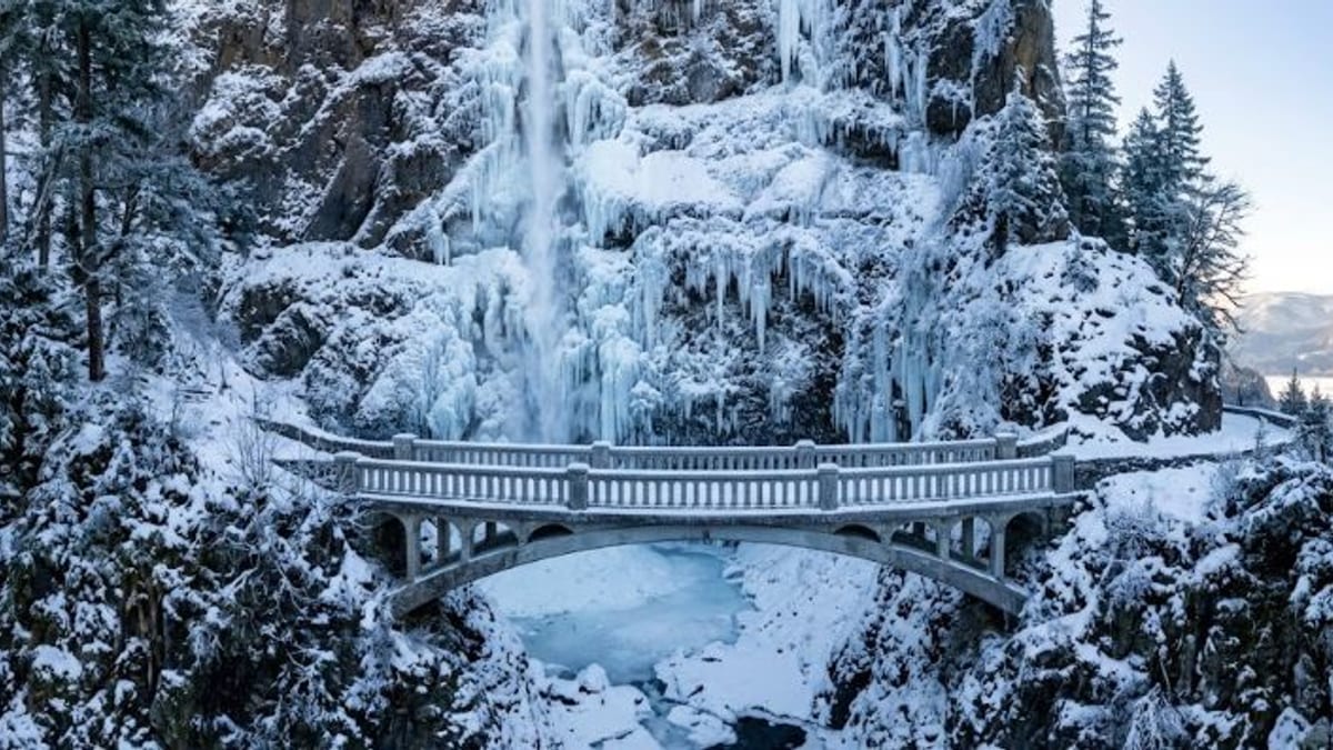
Image by Travel and Tour World – Tourism, Airline, Destination, MICE, Gobal Travel Market, Hotel news that you will find only over here.
A Towering Cascade in a Living Canyon
Multnomah Falls is located on Multnomah Creek in the heart of the Columbia River Gorge National Scenic Area, roughly 30 miles east of downtown Portland. Publicly available information from federal land managers describes it as one of the tallest year round waterfalls in the United States and the most visited natural recreation site in the Pacific Northwest, with visitor numbers frequently topping one million annually.
The falls drop in two main stages, an upper plunge and a lower curtain separated by a narrow ledge, creating the postcard view that has made the site a symbol of Oregon tourism. Interpretive materials highlight how the cliffs behind the white cascade reveal stacked layers of ancient basalt, shaped by volcanic activity and Ice Age floods that carved the Gorge into a steep walled canyon.
Unlike many remote western waterfalls, Multnomah Falls sits immediately beside major transportation routes, which has helped fuel its popularity. Travelers arriving from Portland can reach the site in well under an hour in normal conditions, either on Interstate 84 or along segments of the Historic Columbia River Highway, a scenic roadway that threads past a string of additional waterfalls.
That combination of grand scenery and straightforward access has positioned Multnomah Falls as a gateway experience for first time visitors to the Gorge, while still rewarding repeat travelers with shifting light, seasonal water flows and changing trail conditions throughout the year.
Seasonal Rules Aim to Tame the Crowds
As visitor numbers have grown, transportation agencies and land managers have turned to seasonal systems to manage congestion and safety at Multnomah Falls. Publicly available guidance indicates that timed use permits are now a recurring feature of the busiest months, generally running from late May into early September for vehicles using the dedicated parking area at Interstate 84 Exit 31.
These passes, obtained in advance through an online reservation platform or at limited in person outlets, are intended to meter arrivals into the main lot and reduce the gridlock that has periodically developed when peak season traffic overwhelms the narrow access roads. In recent seasons, published coverage has noted that visitors arriving before mid morning or in the evening hours often do not need a timed entry, a pattern expected to continue as agencies refine the system.
Separate from the permit program, motorists encounter evolving construction related changes along the Historic Columbia River Highway, including viaduct rehabilitation work in the Multnomah Falls area that is scheduled in phases through 2026. State transportation updates describe rolling lane closures and occasional detours, which can alter how drivers approach the waterfall corridor and how long trips take during specific periods.
For travelers, the practical effect is that Multnomah Falls remains accessible but increasingly structured during summer and construction windows. Trip planners are encouraged by tourism agencies to treat permit bookings, alternate routes and possible shuttle or tour options as integral parts of an itinerary, rather than last minute details.
Trails, Bridges and Year Round Adventure
Beyond roadside viewing, Multnomah Falls continues to function as a launch point for short walks and longer hikes that showcase the Gorge’s rugged terrain. Official trail descriptions emphasize the paved climb from the lodge area to the Benson Bridge, the historic span that appears in many photographs midway up the lower falls, as a relatively brief but steep outing suitable for most visitors prepared for switchbacks.
From the bridge, hikers can continue up Larch Mountain Trail number 441, one of the Gorge’s most popular routes, to reach a viewpoint at the lip of the upper falls. Public information notes that this path gains substantial elevation over a modest distance and can feel strenuous, particularly in summer heat or winter conditions when patches of ice linger in shaded corners of the canyon.
More experienced hikers often link Multnomah Falls with neighboring waterfalls on loop routes, creating half day adventures through mossy forest and cliff lined ravines. Trail organizations describe how these routes can involve narrow sections and exposure to steep drop offs, underscoring the importance of proper footwear, staying on marked paths and monitoring seasonal advisories about rockfall or downed trees.
The result is a site that functions both as a quick roadside stop and as the trailhead for more immersive outings, offering options that range from a five minute photo break to a demanding multi hour climb, all within sight or earshot of the constant roar of falling water.
Seasonal Spectacle in Every Direction
Travel information from regional tourism groups presents Multnomah Falls as a true four season destination, with each part of the year emphasizing different aspects of its setting. Winter and early spring typically deliver the strongest water flows, feeding a thundering plume of spray that can coat nearby railings and vegetation. In years with cold snaps, ice formations build around the basalt amphitheater, creating a dramatic but sometimes slippery environment.
Late spring and summer are peak months for casual sightseeing, bus tours and family road trips, coinciding with the busiest days for the timed use permit system and parking controls. Warm weather invites longer hikes into the higher forest, but also brings higher wildfire danger in some seasons, adding another layer to the safety messages shared through official advisories.
Autumn brings thinner crowds and a surge of fall color, as maples and other deciduous trees scattered among the evergreens shift to yellow and red. Photography outlets often highlight this shoulder season as a favorite window for capturing both the falls and the broader Gorge in softer light, especially in the early morning or late afternoon.
Across all seasons, the interplay of the vertical cliffs, the Columbia River below and the changing conditions upstream on Larch Mountain keeps Multnomah Falls visually dynamic, reinforcing its status as a repeat worthy stop rather than a one time checklist item.
A Hub for the Wider Gorge Experience
While the falls are the marquee attraction, Multnomah’s location in the center of the waterfall corridor makes it an effective base for exploring the broader Gorge. Nearby viewpoints such as Crown Point and Vista House, as well as other waterfalls along the Historic Columbia River Highway, are frequently packaged together by tour operators and highlighted in itineraries produced by city and state tourism organizations.
Shuttle services, guided outings and small group tours have expanded in recent years, offering an alternative to self driving during busy periods and construction. Marketing materials promote these options as a way to reduce parking stress, reach multiple viewpoints in a single outing and gain context about the area’s geology and cultural history while leaving the navigation to a professional driver.
At the base of the falls, the historic Multnomah Falls Lodge continues to anchor visitor services, with food, restrooms and information available within a stone building that blends into the cliffside. Public information notes that the lodge operates under a special use arrangement within the national scenic area, helping to maintain services at a site that would otherwise be challenging to manage at such high visitation levels.
For domestic and international travelers alike, Multnomah Falls now occupies a distinctive space on the U.S. travel map: a place where world class scenery sits just off a major interstate, yet is framed by evolving management tools designed to keep that experience safe and sustainable as interest in Oregon’s natural icons continues to grow.