
More news on this day
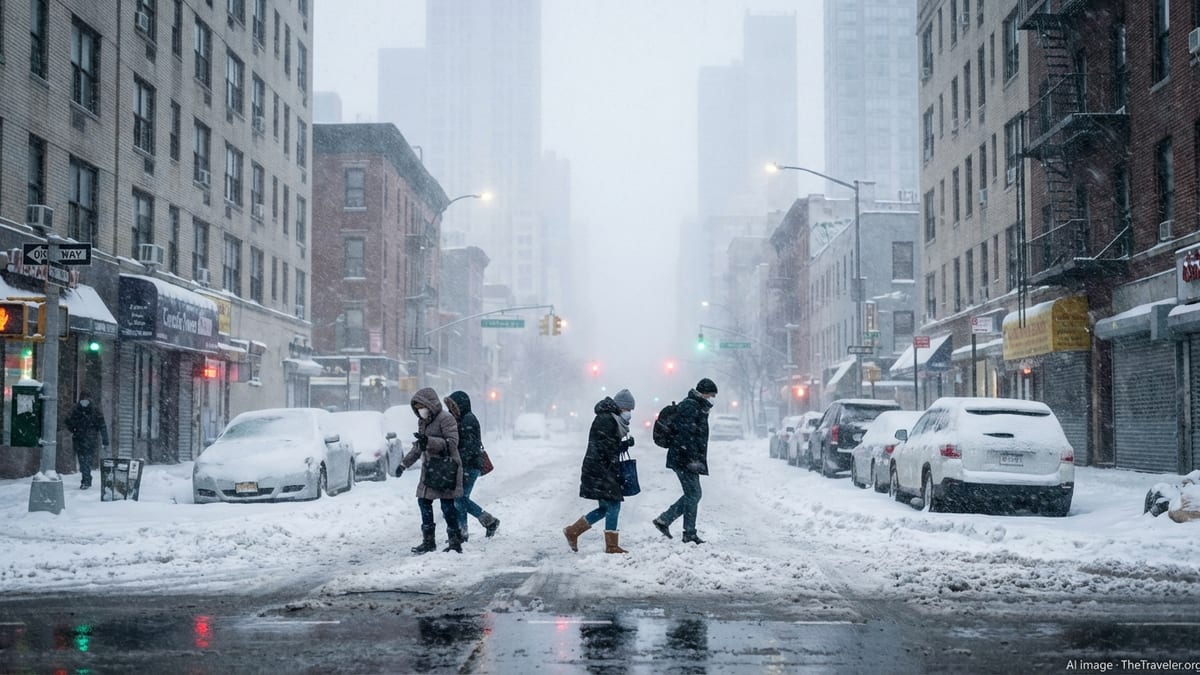
New York is bracing for what officials are calling a potentially historic blizzard, with forecasters warning of life-threatening whiteout conditions, crippling travel disruptions and widespread power outages across the city, Long Island and the lower Hudson Valley from Sunday into Monday.
Forecast: A Powerful Nor’easter Aiming at New York
Forecasters say a rapidly intensifying coastal nor’easter will begin impacting the New York metropolitan area Sunday morning, with snow quickly becoming heavy by afternoon and blizzard conditions developing into the night. The National Weather Service has issued a blizzard warning for all five boroughs, Long Island and parts of the lower Hudson Valley, the first such alert for New York City in nearly a decade.
Snowfall totals across the city and Long Island are expected to reach 15 to 20 inches, with some coastal communities and eastern Long Island at risk of even higher amounts if the storm stalls offshore. Forecast models indicate snow could fall at rates of 1 to 2 inches per hour during the height of the system, especially overnight Sunday into Monday, making it difficult for plows to keep up and quickly burying untreated surfaces.
Powerful winds will compound the danger. Gusts are forecast to reach 50 to 60 miles per hour along the coast, with sustained winds strong enough to create near-zero visibility in blowing and drifting snow. Officials stress that the exact track of the storm could still shift, but the consensus among major forecast centers is that the New York region is squarely in the bull’s-eye for a high-impact event.
Alongside snow and wind, coastal flooding is a growing concern. A combination of high astronomical tides and storm-driven surge is expected to produce minor to locally moderate flooding in vulnerable shoreline neighborhoods from the Rockaways and Coney Island to southern Queens, Brooklyn and Long Island’s South Shore. Residents in low-lying areas are being urged to move vehicles to higher ground and be prepared for road closures around high tide cycles.
State of Emergency and Government Response
In anticipation of the storm’s impact, Governor Kathy Hochul has declared a state of emergency for New York City, Long Island and much of the Hudson Valley. The order, issued on Saturday, covers a swath of downstate counties and unlocks additional powers for state and local agencies to coordinate storm response, restrict travel and rapidly deploy resources where they are needed most.
The governor has activated roughly 100 members of the New York National Guard to support local governments and emergency crews across New York City, Long Island and the lower Hudson Valley. These units will assist with storm cleanup, traffic control, welfare checks in hard-hit communities and logistics for shelters if they are required. State emergency managers have also activated the State Emergency Operations Center to monitor the storm around the clock.
Transportation agencies are shifting into storm mode. The Metropolitan Transportation Authority says crews are pre-positioning equipment, including snow blowers, de-icing trains and extra personnel, to keep critical rail lines and subway infrastructure functioning. On Sunday night, some subway express tracks will be used to store trains underground, protecting them from the heaviest snowfall and allowing faster restoration of service once the storm passes.
Highway officials are preparing for major restrictions as conditions deteriorate. The state has announced a ban on empty tractor-trailers and tandem trucks on Interstate 84 and on major highways south of that corridor, including key stretches of the New York State Thruway near the city. Other commercial vehicles will be limited to right lanes in affected zones, and additional closures are possible if whiteout conditions make roads impassable.
Transit, Flights and Road Travel: Expect Major Disruptions
Travelers are being warned to expect widespread disruptions across all modes of transportation from Sunday through at least Monday evening. Airlines serving John F. Kennedy, LaGuardia and Newark Liberty airports have begun issuing travel waivers and preemptively canceling flights in anticipation of prolonged periods of low visibility and strong crosswinds on runways. Federal aviation planners already list the New York airports among those most at risk for extended delays and ground stops as the storm peaks.
Passengers with flights into or out of the region are being urged to check directly with their carriers before heading to the airport, and to consider rebooking for later in the week if their travel is not essential. Even if runways remain open, airlines may significantly trim schedules to avoid trapping aircraft and crews out of position in the middle of the storm.
On the rails, the Long Island Rail Road plans to operate on a modified Sunday schedule, with the possibility of further reductions or suspensions on branches particularly vulnerable to drifting snow and downed trees. Metro-North Railroad is preparing to run reduced hourly service on its main lines during the storm, with weekend-type schedules on several branches. Officials caution that additional service cuts may be needed if conditions deteriorate or if power problems arise.
For drivers, authorities are using unusually stark language. New York State Police are urging the public to avoid any nonessential travel beginning Sunday afternoon, warning that blowing snow, icy pavement and low visibility will combine to make driving dangerous to nearly impossible at times. Local police departments and public works crews across the region have echoed that appeal, asking residents to stay off the roads so plows and emergency vehicles can move freely.
Utilities, Power Outages and Coastal Risks
Utility companies across downstate New York say they are bracing for significant outages as heavy, wet snow and gale-force winds strain power lines and topple tree limbs. State officials report that more than 5,000 line workers, tree crews and support staff are on standby around the region, with mutual aid teams prepositioned to move into the hardest-hit neighborhoods once it is safe.
The combination of saturated ground from recent storms and the weight of new snow raises the risk that trees and large branches could give way in gusts approaching 60 miles per hour. That could knock out electricity, internet and heat to homes and businesses just as temperatures fall behind the storm. Residents are being urged to fully charge phones and backup batteries, fill prescriptions, and gather flashlights rather than candles to reduce fire risk during any outages.
Along the waterfront, emergency managers are closely watching the potential for coastal flooding, especially on Sunday night and Monday morning. Strong onshore winds associated with the nor’easter are expected to push water into New York Harbor and Long Island’s bays and inlets, leading to water levels one to two and a half feet above normally dry ground in vulnerable areas. Shore roads, parking lots and basements in flood-prone neighborhoods could see water intrusion, particularly if wind-driven waves coincide with high tide.
Officials stress that residents in previously flooded neighborhoods should not wait for last-minute directives. Moving vehicles to higher ground, avoiding underground garages, and securing loose outdoor items are being recommended well before the worst of the storm arrives. Small boats should be firmly tied or hauled out where possible, and people are being advised to stay off jetties, piers and seawalls, where breaking waves and icy spray will pose serious hazards.
How New Yorkers Can Prepare at Home
With the brunt of the blizzard still hours away, emergency management agencies say this is the critical window for residents to prepare. Authorities recommend stocking at least several days’ worth of food, water and essential medications, with an emphasis on items that do not require refrigeration or extensive cooking in case of power loss. Households should locate flashlights, extra batteries and portable chargers, and test smoke and carbon monoxide detectors.
Officials also advise assembling a basic winter emergency kit that can be used at home or, if travel is unavoidable, in a vehicle. Warm clothing layers, blankets, hats and gloves, along with a shovel and ice scraper, are considered essential. Keeping gas tanks at least half full helps prevent fuel line freeze-ups and ensures vehicles can run intermittently for heat if stranded, though residents are reminded to keep tailpipes clear of snow to prevent carbon monoxide buildup.
City and state agencies are reminding New Yorkers to check on elderly neighbors, people with disabilities and others who may need assistance ahead of the storm. Simple steps such as confirming they have enough medication, arranging backup power for medical devices, and sharing contact numbers for local non-emergency hotlines can make a significant difference once conditions deteriorate.
Pet owners are being urged to bring animals indoors and limit time outside during the most intense snow and wind. Officials stress that if it is unsafe for people to be outdoors for more than a brief period, it is unsafe for pets as well. Residents using space heaters are being reminded to keep them at least three feet away from anything flammable and to plug them directly into wall outlets rather than power strips.
Staying Informed and Avoiding Rumors
Authorities emphasize that staying informed through trusted channels is as important as physical preparation. The state is encouraging New Yorkers to ensure that wireless emergency alerts are enabled on their smartphones and to sign up for local notification systems through city or county emergency management offices. These services can deliver real-time information on changing forecasts, road closures, transit disruptions and shelter openings.
Officials warn that during high-impact storms, misinformation and outdated forecasts often circulate widely on social media. Residents are being urged to rely on statements from the National Weather Service, city and state agencies, and established news organizations rather than unverified posts or screenshots. Forecasts for the current storm have evolved quickly over the past 48 hours, with snowfall projections increasing as models converged on a track closer to the coast.
Local governments across the New York metro region are also using text alerts, reverse 911 calls and community email lists to broadcast urgent updates about parking rules, school closures and public facility hours. Residents are encouraged to monitor these messages closely and to pass reliable information to family members who may not have ready internet access, including older adults.
Travelers, meanwhile, are advised to use official airline apps, transit notifications and airport status boards to track changing conditions. Screenshots of earlier schedules may become obsolete as carriers and transit agencies adjust to the storm in real time.
What to Do if You Must Travel
Despite repeated calls to stay home, some New Yorkers will still need to travel during the storm for work, medical care or emergencies. For them, safety experts stress that preparation and caution are nonnegotiable. Before heading out, drivers should clear all snow and ice from windows, mirrors, headlights and roofs, both to improve visibility and to avoid creating hazards for other motorists.
On the road, speeds should be significantly reduced, with extra following distance left between vehicles to allow for longer stopping times on slick pavement. Sudden braking and sharp turns increase the risk of skidding. If visibility drops to near zero in whiteout conditions, drivers are urged to pull off the road at the first safe opportunity, turn on hazard lights and wait for conditions to improve rather than continuing blind into traffic.
If a vehicle becomes stuck, experts recommend staying inside with seat belts fastened until help arrives, particularly on highways where plows and large trucks may have difficulty seeing stranded cars in deep snow. Running the engine periodically for heat is acceptable as long as the exhaust pipe is cleared of snow and a window is slightly cracked to allow fresh air circulation.
For those who rely on public transit, agencies are warning that schedules may change with little notice. Riders should dress for the possibility of extended waits outdoors, carry water and snacks, and have an alternate route or backup plan ready in case a particular line is suspended. Officials caution that station platforms, bus stops and stairways will be extremely slippery at times, and that blowing snow could obscure curbs and gaps.
Looking Ahead: After the Snow Stops
Even after the last flakes fall, New York is likely to face lingering impacts from this storm well into the week. Deep, wind-blown drifts will make side streets, driveways and sidewalks difficult to clear, while mounds of plowed snow at intersections may obstruct sightlines for drivers and pedestrians alike. City sanitation crews are preparing for a multi-day cleanup operation, focusing first on major arteries, bus routes and access to hospitals and firehouses.
Pedestrians are being reminded that property owners are responsible for clearing sidewalks within legally required timeframes once the snow ends, though officials acknowledge that heavy, wet accumulations will make shoveling especially strenuous. They urge residents with health conditions to seek help rather than risk overexertion. Municipal agencies are also asking people to avoid tossing snow back into cleared streets, which can slow plowing and create new ice hazards as temperatures fluctuate.
As winds gradually ease, utility crews will fan out to restore power to neighborhoods that went dark during the height of the storm. Some outages could last into midweek in areas where downed trees have damaged both primary and secondary lines, and where icy conditions slow access for bucket trucks. Emergency managers say they will prioritize critical facilities such as hospitals, nursing homes and shelters, while urging patience from residents in residential areas facing extended restoration times.
For a region still recovering from earlier winter storms, this latest blizzard is expected to test infrastructure, emergency services and residents’ resilience once again. Officials say the next 24 hours will be crucial for preparation, and that the actions New Yorkers take now will help determine how safely the city weathers what could become one of its most memorable winter events.