
More news on this day
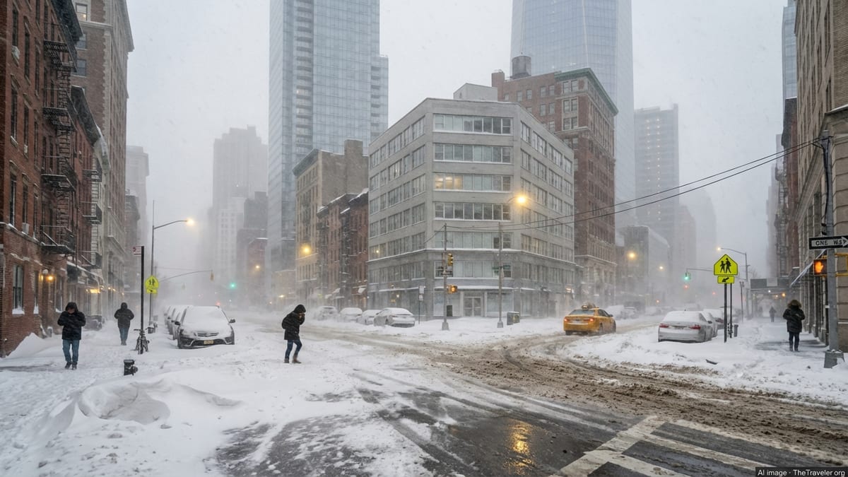
New York City and Long Island are bracing for what officials warn could be a once-in-a-decade blizzard on Sunday night into Monday, with forecasts calling for more than 18 inches of snow in some areas, hurricane-force wind gusts near the coast, widespread power outages and sweeping restrictions on travel across the region.
Rare Blizzard Warning as Nor’easter Rapidly Intensifies
A strengthening coastal nor’easter is expected to undergo explosive intensification off the Mid-Atlantic coastline late Sunday, evolving into a powerful blizzard as it tracks northeastward parallel to the New York and Long Island shoreline. Forecasters say the storm will deliver its most dangerous conditions from late Sunday afternoon, February 22, through midday Monday, February 23, with heavy snow, damaging winds and near-zero visibility for millions of residents.
The National Weather Service has issued a Blizzard Warning for all five boroughs of New York City and for Long Island, where rapidly deteriorating conditions are expected as snow bands pivot inland and winds increase. Forecast models now show 12 to 20 inches of snow across the city, with localized totals exceeding 18 inches in parts of Brooklyn, Queens and eastern neighborhoods most exposed to persistent ocean bands.
Farther east, Suffolk County on Long Island is forecast to bear the brunt of the storm. Meteorologists warn that eastern Long Island, including the Hamptons and Montauk, could see 18 to 24 inches of snow as heavier coastal bands stall over the area and wrap around the strengthening low-pressure system. Combined with severe winds, officials say the event meets every criterion for a historic blizzard for the downstate region.
Unlike more routine winter storms that sweep quickly through the area, this system is expected to slow and deepen off the coast, prolonging the window of intense snowfall and high winds. That slow movement raises the prospect of crippling snow totals, extensive coastal flooding and prolonged disruptions across key transportation corridors from the outer boroughs to the farthest reaches of Long Island.
Hurricane-Force Wind Gusts and Whiteout Conditions Expected
While the projected snowfall totals are alarming on their own, forecasters emphasize that the defining feature of this storm will likely be its winds. Gusts of 55 to 60 miles per hour are expected across much of New York City and coastal Long Island overnight Sunday, with the strongest blasts along exposed stretches of the Atlantic coastline and across barrier beaches.
Along eastern Long Island, wind gusts could approach or even exceed 70 miles per hour at the height of the storm, reaching hurricane-force intensity. Coupled with powdery, wind-driven snow, those gusts are expected to produce frequent whiteout conditions, with visibility dropping to near zero for prolonged periods. Meteorologists caution that travel may become not just difficult but impossible late Sunday night as blowing and drifting snow quickly overwhelm plowing efforts.
The combination of heavy, wet snow and severe winds will also place intense strain on trees, utility poles and above-ground power lines. Officials warn of a significant threat of downed limbs and infrastructure failures, particularly in coastal and suburban communities with mature tree canopies. Power providers across the region are staging extra crews and equipment in anticipation of potentially widespread and long-lasting outages.
Blowing snow and high winds will continue into Monday morning, even as the heaviest snowfall rates begin to diminish. Drifts are likely to reach several feet in some locations, especially around buildings, fences and along highways. Emergency management officials stress that plows and first responders will face extreme challenges navigating blocked or rapidly re-covering roads, underscoring the need for residents to remain off the streets.
State of Emergency and Road Restrictions Across the Region
In anticipation of the storm, New York Governor Kathy Hochul has declared a State of Emergency for 22 counties, including New York City, Long Island and the lower Hudson Valley. The declaration, which took effect Sunday morning, activates additional state resources, including 100 members of the New York National Guard and 25 specialized vehicles pre-positioned across the downstate region to assist with rescue operations, storm response and recovery.
New York City Emergency Management has issued a Hazardous Travel Advisory from Sunday afternoon through Monday, urging residents to avoid all nonessential travel. City officials warn that as snow rates climb to 1 to 3 inches per hour and winds intensify, roads will become treacherous and in some cases impassable. The advisory notes that staying off the streets is critical to allow plows, salt spreaders and emergency vehicles to work effectively.
Local and state transportation agencies are preparing to impose an escalating series of travel restrictions as conditions worsen. These may include speed reductions on major highways, limits or outright bans on tractor-trailers and other high-profile vehicles, and temporary closures of key bridges and parkways vulnerable to high winds and drifting snow. On Long Island, officials are particularly concerned about notorious choke points along the Long Island Expressway and Sunrise Highway, where blinding snow and spinouts have paralyzed traffic during previous storms.
While a full regionwide driving ban had not been implemented as of early Sunday, officials caution that such measures remain on the table if conditions deteriorate more quickly than expected. Residents are being urged to complete any essential travel early in the day and to prepare to remain at home into Monday as cleanup operations begin and crews work to clear main arteries, side streets and emergency routes.
Air, Rail and Transit Networks Face Major Disruptions
New York’s role as a critical transportation hub means the storm’s impacts will extend far beyond city limits. Airlines have already begun issuing travel alerts and waivers for flights into and out of John F. Kennedy, LaGuardia and Newark, with hundreds of preemptive cancellations expected as carriers attempt to reposition crews and aircraft away from the storm’s path. Aviation analysts warn that if forecasts verify, it could take days for the air travel system to fully recover, especially given the interconnected schedules along the busy Northeast corridor.
Major rail providers serving the region, including Amtrak and commuter lines, are warning passengers to anticipate significant delays, truncated schedules and potential suspensions of service. Heavy snow and drifting can obstruct tracks and switches, while high winds pose risks to overhead power lines and catenary systems serving electric trains. Coastal routes, including portions of the Long Island Rail Road, are especially vulnerable to both snow and saltwater spray from storm-driven tides.
Within the city, the Metropolitan Transportation Authority is preparing for a complicated response on both its subway and bus networks. While underground subway lines are generally more resilient to snow, above-ground segments and elevated tracks are prone to accumulation and drifting, potentially forcing service reductions or shutdowns along exposed stretches. Bus routes, meanwhile, are likely to face severe disruptions as streets clog with snow and visibility deteriorates.
Officials are urging riders to check real-time service updates and to expect early shutdowns or reduced operations Sunday evening, when conditions are forecast to deteriorate rapidly. Those who must travel for essential work are encouraged to build in extra time, carry winter gear and consider alternative routes in case of sudden changes to service.
Coastal Flooding Threat for Low-Lying Neighborhoods
In addition to snow and wind, the storm is expected to drive significant coastal flooding along shorelines in and around New York City and Long Island. A prolonged period of onshore winds, combined with astronomically higher tides, will push water into vulnerable bays and inlets Sunday night, raising the risk of inundation in low-lying neighborhoods.
Emergency managers warn that widespread minor coastal flooding is likely, with pockets of moderate flooding possible in areas such as Jamaica Bay, the south shore of Long Island, Staten Island’s east and south shores, and the tip of lower Manhattan. High water levels may coincide with the worst of the snowfall and wind, complicating response efforts and exacerbating damage in waterfront communities.
Residents in flood-prone zones are being advised to move vehicles to higher ground, secure outdoor equipment and be prepared for sudden road closures near shorelines, including sections of the FDR Drive, Belt Parkway and key access roads along the Rockaways and Long Island’s South Shore. Local governments are preparing to deploy temporary barriers and pumps where possible, although officials emphasize that extreme conditions may limit what can be done during the height of the storm.
While the current forecast does not indicate storm surge on the scale of past hurricanes, the overlap of intense snowfall, powerful winds and tidal flooding could produce complex hazards in coastal neighborhoods, especially where drainage systems are already stressed. Authorities urge residents to heed any evacuation guidance or parking restrictions issued at the neighborhood level.
City and State Mobilize for Large-Scale Response
Across New York City and Long Island, public works crews have shifted into 24-hour operations to prepare for the onslaught. The Department of Sanitation has pre-treated major roads and is preparing to deploy thousands of plows and salt spreaders as soon as snow begins to accumulate. Officials say staffing has been ramped up, with personnel placed on extended shifts and nonessential operations suspended to free up workers and equipment.
Hospitals, fire departments and emergency medical services have activated winter storm protocols, including additional staffing, pre-positioned ambulances and coordination with state and local emergency management. Hospitals are working to ensure adequate supplies of fuel, oxygen and critical medications in case hazardous roads delay deliveries. Some facilities have encouraged staff to stay on-site overnight to maintain staffing levels during the worst of the storm.
On Long Island, county executives report close coordination with state agencies to monitor conditions on major arteries and to prioritize the rapid clearing of routes serving hospitals, police and fire stations, and critical infrastructure such as power plants and substations. Utility companies have staged bucket trucks, repair crews and tree removal teams around the region, with mutual-aid agreements in place to call in additional reinforcements from less-affected areas if outages spread.
Emergency shelters and warming centers are on standby in case power failures leave residents without heat for extended periods. Outreach teams are working with unhoused New Yorkers to connect them with indoor accommodations before conditions worsen, while community-based organizations are mobilizing to check on seniors, people with disabilities and others who may have difficulty securing essential supplies or evacuating if conditions demand it.
Residents Urged to Prepare and Avoid Nonessential Travel
As the storm’s arrival nears, officials across city and state government are delivering a consistent message: prepare now and stay off the roads once the snow and wind intensify. Residents are being advised to stock up on essential items such as food, water, medications and batteries, and to ensure that phones and backup power banks are fully charged ahead of potential outages.
Authorities recommend that anyone who must drive carry a winter emergency kit, including warm clothing, blankets, a flashlight, a small shovel and basic supplies in case they become stranded. However, they stress that the safest option, particularly overnight Sunday, will be to avoid travel entirely. With snowfall rates potentially topping 2 to 3 inches per hour at times, even short trips could quickly become dangerous.
New Yorkers are also being reminded to clear snow from sidewalks and building entrances once it is safe to do so, keeping in mind that city regulations require property owners to maintain accessible walkways after storms. At the same time, officials urge residents not to overexert themselves while shoveling, especially in bitterly cold and windy conditions, and to check on neighbors who may need assistance.
For now, forecasters say confidence is high that the region will experience one of its most severe winter storms in years. While exact snowfall totals will depend on the precise track and intensity of the low-pressure system, authorities caution that the combination of deep snow, hurricane-force gusts in exposed coastal areas and extensive travel restrictions will likely bring much of New York City and Long Island to a standstill through at least Monday, leaving a massive cleanup effort in its wake.