
More news on this day
A fast-intensifying nor’easter is bearing down on New York, with Governor Kathy Hochul declaring a state of emergency for more than 20 counties as forecasters warn of blizzard conditions, feet of snow, dangerous travel and the heightened risk of power outages from Sunday night into Monday.
Wide-Ranging State of Emergency Across Downstate New York
The emergency declaration, issued on February 21, covers a broad swath of downstate New York, from the Capital Region through the Hudson Valley and into New York City and Long Island. Counties under the order include Albany, Bronx, Columbia, Greene, Delaware, Dutchess, Kings, Nassau, New York, Orange, Putnam, Queens, Richmond, Rockland, Schenectady, Schoharie, Suffolk, Sullivan, Ulster, Westchester and contiguous areas where conditions are expected to deteriorate rapidly as the storm intensifies.
By Sunday, February 22, blizzard warnings and winter storm warnings stretched from the mid-Atlantic into New England, but New York is forecast to be among the hardest-hit. The nor’easter is expected to tap Atlantic moisture and collide with bitterly cold air, creating a dangerous combination of heavy, wet snow and damaging winds that will test both transportation systems and power infrastructure across the region.
State officials say the emergency order allows agencies to move equipment and personnel more quickly, streamline contracting and waive certain regulations to speed storm response. It also provides a legal framework for travel restrictions and local emergency orders in counties where conditions become life-threatening.
Snowfall Totals and Wind Gusts Threaten Travel and Power
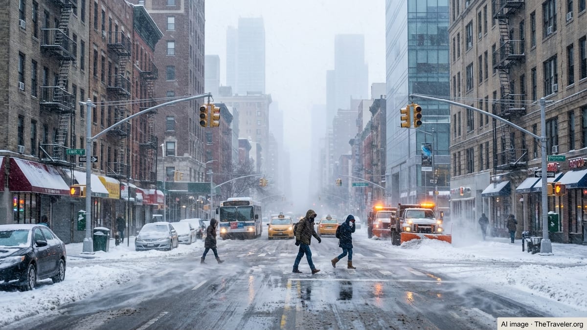
Forecast models on Sunday afternoon pointed to some of the most significant snowfall the New York City region has seen in a decade. Long Island and the five boroughs are projected to receive 18 to 24 inches of snow, with localized totals potentially higher where intense snow bands set up. The lower Hudson Valley, including Rockland, Orange, Putnam, Westchester, Dutchess and Ulster counties, could see 12 to 18 inches, while the Capital Region around Albany is expected to receive 5 to 12 inches depending on elevation and distance from the coast.
Equally troubling are the winds. Along the coast and in the New York City and Long Island metro areas, gusts could exceed 55 to 60 miles per hour at the height of the storm, strong enough to produce whiteout conditions and scattered tree damage. Inland counties such as Columbia, Greene and Delaware still face gusts of 35 to 45 miles per hour, enough to blow and drift snow across already snow-covered highways.
Meteorologists warn that the combination of heavy, wet snow and strong winds will significantly raise the risk of power outages, particularly on Long Island and along coastal sections of Queens, Brooklyn, Staten Island and the Bronx where overhead lines remain vulnerable. Utilities have called in mutual aid crews, with several thousand workers pre-staged across the state to respond to downed lines and damaged equipment once conditions allow them to safely access affected neighborhoods.
Travel Bans, Transit Cuts and a Crippling Monday Commute
Local and state officials are moving aggressively to keep people off the roads as conditions worsen. Rockland County ordered an emergency travel ban beginning Sunday evening, allowing only emergency vehicles and essential personnel on the roads. In New York City, a full travel ban is scheduled to take effect Sunday night, aligning with the period forecasters say snowfall rates could reach one to two inches an hour, combined with near-hurricane-force gusts in exposed areas.
On the state highway system, restrictions on commercial vehicles are being imposed along key corridors. Empty tractor trailers and tandem trucks are barred from I-84 and many routes south of that line, including busy stretches of the Thruway serving Orange, Rockland and Westchester counties. Other commercial vehicles are being confined to right-hand lanes to reduce the risk of jackknifes and multi-vehicle pileups in whiteout conditions.
Rail and transit agencies are also paring back service. The Long Island Rail Road plans to operate on a reduced, Sunday-style schedule with the flexibility to suspend individual branches if drifts overwhelm efforts to keep tracks clear. Metro-North Railroad is shifting to hourly service on core lines into Manhattan and weekend schedules on some branch lines, while the New York City subway is preparing to store dozens of trains underground on express tracks to shield them from snow and ice, a move that will trigger service changes and delays into Monday morning.
Impacts on New York City, Long Island and Key Travel Hubs
For New York City and Long Island, the storm represents the first blizzard warning in nearly a decade, marking a sharp contrast with several comparatively mild recent winters. Officials are warning residents in Kings, Queens, New York, Bronx and Richmond counties to expect near-zero visibility at times, rapidly accumulating drifts and treacherous conditions on all but the most heavily treated roadways.
Major airports are already feeling the strain. Flight tracking data on Sunday showed thousands of cancellations and delays nationwide as airlines preemptively trimmed schedules at John F. Kennedy International Airport, LaGuardia Airport and nearby Newark Liberty International Airport. With heavy snow and crosswinds forecast overnight and into Monday, operations at the region’s three main hubs are likely to be sharply curtailed, with additional disruptions rippling across the national network as crews and aircraft are stranded out of position.
On Long Island, Suffolk and Nassau counties are bracing for some of the highest snow totals and most dangerous wind gusts in the state. Coastal communities along the South Shore face the added risk of minor to moderate flooding as the nor’easter pushes water toward the shoreline, especially during high tide cycles. Officials there are urging residents to move vehicles away from flood-prone streets and to be prepared for localized road closures where plows cannot safely operate.
National Guard Activation and Local Emergency Response
To bolster the front-line response, Governor Hochul has activated 100 members of the New York National Guard, along with approximately two dozen specialized vehicles designed to operate in deep snow and icy conditions. Guard units are being staged across New York City, Long Island and lower Hudson Valley counties, including Westchester and Rockland, where they will support local agencies with welfare checks, debris clearance and transport for critical medical staff.
County emergency operations centers from Albany to Suffolk are operating around the clock, coordinating snowplow fleets, tow trucks, shelter staff and public information officers. In Albany County and the surrounding Capital Region, plow crews are preparing for several rounds of snow as the storm’s bands pivot inland, with some municipalities enacting overnight parking bans to keep streets clear for heavy equipment.
Police and fire departments across the affected counties are asking residents to reserve 911 calls for genuine emergencies, noting that high winds and drifting snow may slow response times. State Police have issued multiple advisories urging drivers to stay home, warning that even four-wheel-drive vehicles can quickly become stranded when visibility drops and plows are temporarily pulled from the roads for safety.
Advice for Residents and Travelers in the Storm’s Path
Emergency managers across the region emphasize that the safest choice for most residents is to complete essential errands before snow intensifies, then remain indoors until plows are able to make meaningful progress. Those living in Albany, Bronx, Columbia, Greene, Delaware, Dutchess, Kings, Nassau and the other counties under the emergency order are advised to have at least several days’ worth of food, water, prescription medications and pet supplies on hand.
Travelers still planning to move through the region are being urged to reconsider. For those who must drive, officials recommend packing blankets, warm clothing, a flashlight, a fully charged phone and an external battery, along with sand or kitty litter for traction should vehicles become stuck. Authorities stress that conditions can change within minutes, with passable roads quickly turning into whiteouts as heavier snow bands rotate across major corridors.
For visitors who may be unfamiliar with harsh Northeast winter storms, local tourism and consular offices are circulating advisories in multiple languages encouraging guests to postpone nonessential travel, stay informed through local media, and confirm directly with hotels, transportation providers and attractions before attempting to move around the metropolitan region.
What to Expect After the Storm Passes
Although snowfall is expected to taper from west to east sometime Monday afternoon, many impacts will linger well beyond the final flakes. Snow removal from city streets, suburban cul-de-sacs, village centers and rural routes across the Catskills and Hudson Valley could take days, particularly in neighborhoods that see more than a foot of accumulation. Narrow streets in older parts of the Bronx, Brooklyn and lower Manhattan will pose an additional challenge as plows struggle to navigate around parked cars and snowbanks.
Airlines caution that even once runways are cleared and skies brighten, getting aircraft and crews back into position will take time, leading to residual delays and cancellations at New York’s airports and at major connecting hubs across the United States. Rail operations may also be affected as agencies inspect tracks, switches and overhead power lines for ice damage and clear snow from platforms and station access points.
A brief warming trend is expected later in the week, which could aid cleanup efforts but also introduce new hazards such as melting snow, slushy sidewalks and refreezing overnight. In low-lying riverfront neighborhoods along the Hudson and in coastal sections of Queens, Brooklyn and Long Island, heavy snowmelt combined with any lingering coastal flooding could lead to ponding on roads and waterlogged basements, underscoring the need for residents to keep storm drains and gutters as clear as possible once it is safe to work outside.
Implications for Winter Travel and Tourism
For travelers and tourism operators, the blizzard is an abrupt reminder of how quickly winter can reshape plans across one of the world’s busiest urban corridors. Hotels in New York City, Westchester and Long Island are preparing for an influx of stranded passengers and motorists seeking last-minute rooms, while some upstate lodging providers in the Capital Region and western Hudson Valley are receiving calls from visitors hoping to ride out the storm in place rather than risk driving home.
Tourism officials say that while iconic attractions from Times Square to Albany’s historic district may be quieter during the height of the storm, the rapid transformation of the cityscape can offer a striking, if temporary, perspective on the region. They caution, however, that iconic winter scenes come with real risks, and that anyone venturing outside for photos or short walks should watch for falling ice, heed police tape around unsafe areas and stay well clear of snowplows and other heavy equipment.
With more storms possible later in the season, emergency managers are urging both residents and returning visitors to treat this blizzard as a learning moment. Having a flexible itinerary, travel insurance that covers weather-related disruptions, and a realistic understanding of how long it takes for a region of nearly 20 million people to dig out after a major snow event can all help minimize stress the next time a nor’easter sets its sights on New York.