
More news on this day
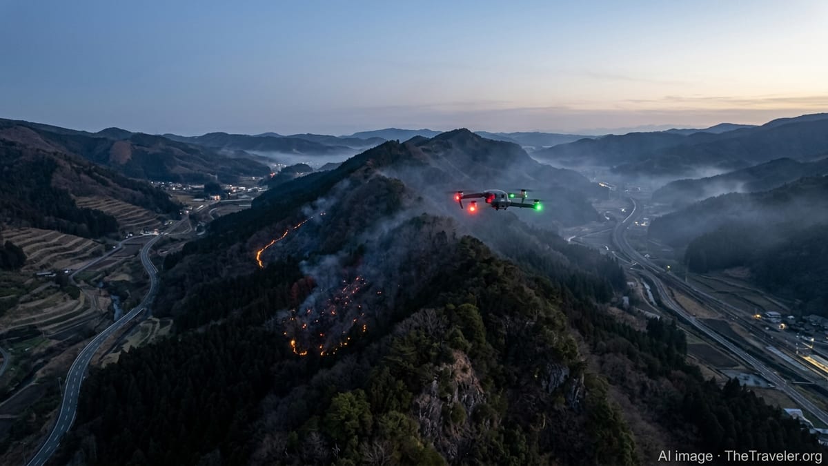
Japan’s latest wildfire on Mount Ogi has become an unexpected test bed for a new generation of disaster-response drones, with Tokyo-based Blue Innovation using night flights and rapid mapping to show how smarter aerial operations could prevent the kind of transport shutdowns and travel chaos that often follow major fires.
Get the latest news straight to your inbox!
Mount Ogi Blaze Becomes a Live Demonstration of Drone Response
The Mount Ogi fire, in a mountainous area known for hiking and scenic travel routes, has underscored how quickly wildfires can spill over into transport disruption in Japan. Steep terrain, narrow roads, and fast-changing winds typically make it difficult for ground teams to assess the spread of flames in real time, leading to precautionary road closures, suspended rail services, and sudden changes to tourism itineraries.
Blue Innovation, a Japanese company specializing in drone and robotics solutions, has moved into this gap by deploying drones to fly at night over the affected slopes. Publicly available information on the company’s broader disaster work shows that it has developed systems to automate launch, flight, and data collection, combining aerial imagery with location and terrain data to generate detailed situational maps. Applying similar methods over Mount Ogi allows emergency planners to see the fire perimeter and smoke behavior during hours when manned aviation is largely grounded.
The night flights provide a continuous layer of observation that ground crews alone struggle to match. By stitching together images into near-real-time maps, the operation turns Mount Ogi into a model for how remote areas with limited access can still be monitored safely, without putting additional personnel into hazardous zones or relying solely on daytime helicopter sorties.
For a region that attracts domestic travelers and international visitors alike, the ability to maintain a clear picture of the fire’s evolution is critical. More precise knowledge of where flames and hotspots are located gives authorities stronger justification for keeping certain roads open, maintaining access to key hubs, or reopening routes sooner once conditions are genuinely safe.
Blue Earth Platform Extends to Wildfire Mapping
The Mount Ogi deployment builds on technologies that Blue Innovation has refined across Japan in recent years. The company’s Blue Earth Platform, a control and data-management system for drones and other autonomous devices, has been used to coordinate fleets for inspections, logistics, and disaster response in complex environments. Reports on its tsunami-alert projects and post-earthquake inspections highlight how the platform links flight control, sensor data, and cloud processing into a single operational picture.
In the wildfire context, the same platform can integrate thermal cameras, optical sensors, and geographic data to map fire lines, identify remaining embers, and estimate likely spread. At Mount Ogi, this type of integrated approach turns a handful of night flights into a continuous information stream that planners can overlay with maps of transport infrastructure, forest trails, and nearby communities.
Previous Blue Innovation projects have demonstrated that drones can be launched from automated ports on rooftops, triggered by national alert systems, and flown along preprogrammed routes. Applying that philosophy to wildfire monitoring suggests a future in which mountain regions like Ogi are ringed by small, unattended drone stations ready to activate as soon as a fire is detected, sending imagery and alerts to control centers without waiting for human pilots to arrive.
Such a model is particularly relevant for Japan’s aging rural populations and labor-constrained local governments. Automated monitoring of remote slopes and forested ridges can support small local teams while still providing the level of data needed to protect major rail lines, highways, and tourism corridors from unnecessary closures.
From Tsunami Alerts to Tourism-Safe Fire Corridors
Blue Innovation’s work at Mount Ogi reflects lessons learned from earlier coastal safety projects. In Chiba Prefecture and Sendai, the company’s drones have already been used as airborne warning tools, automatically launching from dedicated ports when national alert systems detect tsunamis or severe weather. Those operations have shown that drones can broadcast messages along beaches, capture live video, and relay conditions back to municipal control rooms even when roads are flooded or blocked.
Translating that experience inland, the Mount Ogi fire response shows how the same combination of automated launch, preplanned routes, and live video feeds can support wildfire management. Instead of patrolling coastlines, the aircraft now trace ridgelines and valleys, providing clarity on which areas are threatened and which remain safe for transit.
For travelers, this shift could be decisive. Wildfires in scenic mountain regions often prompt blanket closures as a precaution, leaving tourists stranded or prompting mass cancellations. With more precise mapping from night-flying drones, planners are better positioned to maintain so-called fire corridors where risk remains low, keeping key rail links, expressways, and bus routes operating while only the most exposed sections are restricted.
Moreover, the same imagery that informs emergency teams can contribute to public-facing updates that are easier for travelers to understand. Clear maps and route-specific status reports reduce uncertainty for visitors trying to decide whether to proceed with journeys that pass near Mount Ogi and similar destinations.
Limiting Travel Chaos Through Faster, Data-Rich Decisions
Travel disruption during disasters is often less about direct damage to infrastructure and more about information gaps. When decision-makers lack up-to-date data on fire fronts, smoke plumes, or potential landslides, the safest option is to close wide areas to movement. This can strand residents, delay supply deliveries, and derail travel plans for days, even when only a small section of a route is actually at risk.
Night drone deployments like those at Mount Ogi are designed to shrink that information gap. Continuous mapping enables shorter feedback loops: if a fire’s advance toward a rail line slows or reverses, services can resume sooner; if smoke shifts away from a highway, speed restrictions rather than full closures may be sufficient. For airlines and long-distance train operators planning tight schedules, these distinctions matter.
Publicly available studies on wildfire-monitoring drones highlight their value in capturing perimeter changes and spotting new ignitions. Integrating that capability with platforms such as Blue Innovation’s allows transport operators and tourism agencies to move from rough, zone-based decisions toward more granular assessments tied to specific tunnels, bridges, and stations. Over time, this could reduce the number of days each year in which large portions of Japan’s network are shut down as a precaution.
The approach may also support faster post-disaster recovery. Once flames are contained, the same drones can switch to damage assessment, flying set routes over rail beds, road cuttings, and cable corridors to check for heat damage, fallen trees, or loosened slopes, helping engineers decide which segments can safely reopen to traffic.
Implications for Future Travel in Japan’s High-Risk Landscapes
Japan’s combination of dense infrastructure and high natural hazard exposure has long challenged travel planners. Mountainous regions like Mount Ogi offer some of the country’s most scenic rail journeys and hiking routes, but they are also exposed to wildfires, landslides, and strong winds. Until recently, ensuring safety meant accepting frequent, sometimes prolonged interruptions to mobility.
The Mount Ogi night drone operation suggests a different trajectory. As platforms such as Blue Innovation’s mature, they may enable a new standard in which remote destinations are continuously monitored from the air, and where automated vertiports on public buildings and transport hubs form part of a resilient safety net. For travelers, this could translate into fewer last-minute cancellations and more accurate, timely information when disruptions are unavoidable.
There are still hurdles to overcome, including weather limitations, airspace coordination, and the funding required to install automated ports across wide areas. However, the combination of recent disaster-relief experience and ongoing partnerships in logistics, infrastructure inspection, and training indicates that the technology is moving from isolated pilot projects to a more integrated national role.
For Japan’s tourism industry, which depends heavily on reliable rail and road access to mountains and coasts, the Mount Ogi operations are a clear signal. Night-flying drones, sophisticated mapping, and automated launch systems are no longer experimental concepts. They are emerging as practical tools that can keep people moving safely, even when wildfires threaten some of the country’s most visited landscapes.