
More news on this day
As wildfires and extreme weather intensify across Japan, homegrown drone pioneer Blue Innovation is drawing attention with nighttime flights over Mount Ogi, demonstrating how autonomous aerial mapping could sharpen disaster response and help keep travel networks running when nature turns volatile.
Get the latest news straight to your inbox!
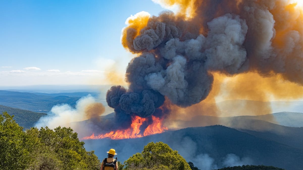
Image by Global Travel Alerts, Advisories, International Travel Alerts
Blue Innovation’s Disaster Tech Reaches Japan’s Mountain Regions
Publicly available information on Blue Innovation shows a company that has spent years building autonomous drone and “drone port” systems for disaster prevention, including tsunami warning and severe weather alerts in Japanese coastal communities. Recent coverage of its BEP Port Disaster Prevention System highlights how fleets of drones can be scrambled automatically when alarms sound, delivering rapid situational awareness over ports and rivers where traditional ground patrols struggle.
Applying that expertise to mountainous terrain such as Mount Ogi marks a logical next step for Japan’s climate resilience strategy. Steep slopes, thick forests and fast-changing winds can turn even a localized fire into a complex emergency, limiting what ground crews can see and how quickly they can react. By flying at night, drones equipped with thermal cameras and low-light sensors can cut through darkness and smoke to map hot spots, track fire lines and spot new ignitions before they flare out of control.
Reports on recent wildfire seasons in Japan and abroad indicate that emergency agencies are increasingly turning to drones to supplement helicopters and manned aircraft. Night operations are emerging as a critical frontier, since fires often intensify after sundown when winds shift and human visibility drops. Mount Ogi’s rugged profile makes it an ideal testbed for proving how automated takeoff, pre-programmed flight paths and real-time data links can function when conditions are at their worst.
Observers of Japan’s disaster policy note that such deployments fit within a broader national push to blend robotics, sensors and artificial intelligence into emergency management. Blue Innovation’s portfolio of autonomous docks and integrated alert systems is seen as part of a new infrastructure layer, where drones are treated less as ad hoc gadgets and more as permanent, networked assets ready to launch the moment a fire is detected.
Thermal Imaging at Night Transforms Fireground Intelligence
At the core of the Mount Ogi concept is the ability to operate safely after dark. Conventional aircraft are often grounded at night or in heavy smoke due to visibility and crew safety concerns. In contrast, unmanned systems can rely on infrared sensors and onboard navigation to fly pre-planned routes over the fire, gathering granular thermal data even when human pilots could not safely remain in the air.
Technical documentation and industry studies on wildfire drones describe how thermal imaging can distinguish between active flame fronts, smoldering material and already cooled areas. When processed into digital maps, those images show fire commanders precisely where suppression resources are needed and where limited water or retardant drops will have the most impact. Over Mount Ogi’s forested slopes, such insight can mean the difference between a quickly contained incident and a growing blaze that threatens surrounding communities or key transport arteries.
Nighttime drone mapping can also support predictive modeling. By repeatedly flying the same routes over several hours, systems can capture how a fire behaves in response to changing wind, humidity and terrain. Analysts can then feed that data into simulations that estimate likely spread patterns by morning, allowing authorities to pre-position crews, protect vulnerable corridors and plan evacuations if necessary.
Global research into wildfire innovation points to a trend toward persistent, 24-hour aerial surveillance using combinations of drones, balloons and fixed cameras. Blue Innovation’s work, as presented in recent disaster-preparedness coverage, places Japan within that movement, adapting international best practices to domestic landscapes such as Mount Ogi and other mountain ranges that anchor the country’s tourism economy.
Protecting Rail Lines, Highways and Visitor Access
For travelers, the most visible impact of wildfires is often disruption rather than direct danger. In Japan’s regional hotspots, a single fire near a pass or tunnel can prompt rail suspensions, highway closures and last-minute cancellations of tour itineraries. By providing detailed, near-real-time maps of fire behavior at night, drone deployments over Mount Ogi have the potential to reduce the scale and duration of those disruptions.
Transport planners and tourism operators increasingly depend on accurate, up-to-date information before deciding whether to shut a route or keep services running. When data is limited, the safest option is usually to close wide areas around a suspected hazard. Drone imagery can narrow that uncertainty, showing exactly which slopes are affected, how far flames remain from tracks or roads, and whether smoke conditions are likely to impair visibility by dawn.
In practice, that means rail operators may be able to keep more sections open or restart morning services sooner after a nighttime incident. Highways that might otherwise face full closures could instead see targeted lane restrictions or rolling speed limits based on precise risk zones. For travelers connecting between regional rail, buses and domestic flights, such fine-grained management can prevent cascading delays that ripple across an entire day’s schedule.
Tourism boards and local governments are also exploring how better disaster intelligence can preserve confidence in mountain destinations. Rather than enduring long periods of blanket advisories that discourage visitors, communities around Mount Ogi could use drone-based assessments to provide more nuanced updates. If fires are contained to specific valleys and key access routes remain secure, travel plans may need only minor adjustments instead of full cancellations.
Japan’s Drone Leadership and Global Disaster-Response Trends
Japan’s expertise in robotics and automation has naturally extended into drones for public safety. Coverage of domestic initiatives highlights a mix of government-backed research projects, private-sector solutions from firms like Blue Innovation and pilot programs in cities and coastal regions. These efforts intersect with global trends in which drones are deployed for early wildfire detection, real-time mapping, damage assessment and logistics support.
In Europe and North America, innovation catalogues and case studies describe heavy-lift autonomous drones that can carry sensors, communications relays and even firefighting payloads, operating around the clock to reduce risks to firefighters. Similar concepts are taking shape in Japan, with an emphasis on tight integration with existing alert systems and the country’s dense network of rail, road and coastal infrastructure.
Mount Ogi’s nighttime operations sit at this crossroads of local need and international experimentation. By focusing on mapping and situational awareness rather than direct suppression, Blue Innovation’s approach aligns with research that identifies information gaps as one of the biggest obstacles in fast-moving disasters. Better data, gathered earlier and shared more widely, is seen as key to limiting economic damage and preserving travel continuity.
Analysts of climate adaptation finance point out that such technologies are moving from niche trials into mainstream planning, as insurers, transport operators and tourism stakeholders factor disruption costs into their risk models. Accurate drone-based mapping over places like Mount Ogi can support more precise loss estimates, influence infrastructure investments and guide policies that balance visitor access with safety.
From Experimental Flights to Everyday Emergency Infrastructure
While Mount Ogi provides a dramatic backdrop for nighttime drone flights, the long-term significance lies in how quickly such operations become routine. Reports on Blue Innovation’s disaster-prevention platforms emphasize automated launch, remote monitoring and minimal on-site staffing, features designed to make drones a seamless part of emergency infrastructure rather than a special-purpose tool.
As regulatory frameworks in Japan and other countries evolve to allow more beyond-visual-line-of-sight and night operations, observers expect drone networks to expand beyond ports and selected test sites into wider regional coverage. In that scenario, a fire on Mount Ogi could trigger a coordinated response in which multiple aircraft launch from dispersed docks, each assigned to specific sectors, feeding data into common mapping dashboards used by both emergency managers and transport coordinators.
For travelers, the shift may be mostly invisible, experienced only as fewer last-minute cancellations and more precise updates when natural hazards occur. For destinations, the presence of always-ready aerial eyes could become a selling point, signaling that local authorities and technology providers are committed to keeping both residents and visitors moving even in the face of climate volatility.
Mount Ogi’s nighttime drone operations thus represent more than a technical demonstration. They encapsulate a broader transition in which autonomous aerial systems, pioneered by Japanese firms such as Blue Innovation, become central to disaster preparedness and, by extension, to protecting the reliability of travel across some of the country’s most scenic yet vulnerable landscapes.