
A brutal late-winter storm is hammering New Hampshire and neighboring New England states with heavy snow, punishing winds and treacherous ice, unleashing a cascading travel nightmare across one of the nation’s busiest cold-weather corridors.
Region Braces as Another Major Winter Blast Sweeps In
The latest in a relentless series of winter systems is surging across the Northeast, targeting New Hampshire, Maine, Rhode Island, Connecticut and Massachusetts with a volatile mix of heavy snow, blowing snow and pockets of freezing rain. Meteorologists say the storm, energized by sharp temperature contrasts and strong upper-level winds, is poised to deliver some of the harshest conditions of the season for parts of New England.
Winter storm warnings and advisories have been hoisted across a broad swath of the region as forecasters warn of rapidly deteriorating conditions on highways, local roads and runways. While snowfall totals are expected to vary from coastal slush to deep inland drifts, the common denominator is hazardous travel, low visibility and bitter wind chills.
The storm follows on the heels of a punishing January system that buried communities from Texas to Maine and a powerful bomb cyclone off the East Coast at the start of February. For many residents and travelers, this latest blast feels less like an isolated event and more like the climax of a winter that has refused to loosen its grip.
Heavy Snow, Fierce Winds and Dangerous Cold
Forecasters with the National Weather Service say the primary threat for interior New Hampshire, Maine and much of inland Massachusetts is heavy, rapidly accumulating snow accompanied by strong wind gusts that could exceed 40 to 50 miles per hour in exposed areas. That combination is likely to produce blowing and drifting snow, near-whiteout bursts and wind chills that can make already subfreezing air feel far colder.
Closer to the coast, including sections of Rhode Island, eastern Massachusetts and coastal Maine, the storm is expected to transfer more of its punch into mixed precipitation. Bursts of snow may flip to sleet and freezing rain before changing back to snow, creating an unpredictable patchwork of slush, ice and compacted snow on roads and sidewalks. Even limited ice accretion, forecasters caution, can transform routine commutes into perilous journeys.
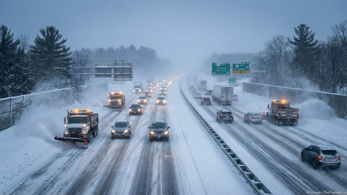
Travel impacts will be magnified by the storm’s timing, with the heaviest bands of snow and mixed precipitation overlapping with morning and evening rush hours in several major metros. Highway cameras have already begun to show slow-moving traffic, long backups and vehicles struggling to gain traction on untreated stretches of pavement as visibility drops and roadway conditions worsen.
Air, Rail and Road Travel Snarled Across New England
Major airports across the region, including those serving Boston, Manchester, Providence and Portland, have enacted proactive cancelations and delays as airlines attempt to stay ahead of the storm’s most intense phase. Carriers are consolidating flights, repositioning aircraft to less affected hubs and urging passengers to rebook early, warning that seats on later flights are already becoming scarce.
On the ground, state transportation departments are deploying plow and salt fleets in continuous shifts, but officials acknowledge that during the peak of the storm, snow may fall faster than it can be cleared. Plows in parts of New Hampshire and Maine are working in tight convoys, trying to keep critical corridors passable while battling blowing snow and low visibility that can reduce sightlines to just a few car lengths.
Rail operators are also under strain. Passenger trains in portions of New England are running on modified schedules, with some routes shortened or temporarily suspended as crews contend with snow-clogged switches, iced-over platforms and downed tree limbs along exposed stretches of track. Travelers are being urged to check schedules frequently and prepare for last-minute changes as conditions evolve.
New Hampshire at the Heart of the Storm’s Snow Belt
New Hampshire sits squarely in one of the storm’s heaviest snow zones, with the state’s interior and higher elevations expected to see some of the largest accumulations. Early reports from transportation officials describe a flurry of spinouts and minor collisions along major interstates and turnpikes as snowfall intensity increases and winds whip flakes into horizontal sheets across the roadway.
State police have reduced speed limits on several key highways in an effort to curb accidents, and troopers are warning drivers not to be fooled by briefly cleared pavement. With temperatures expected to remain well below freezing, even a thin layer of compacted snow can quickly turn to an invisible sheen of ice. Authorities say the number of weather-related calls, from disabled vehicles to crashes, is climbing as the storm deepens.
Mountain communities and ski areas, while accustomed to heavy snow, are also adjusting operations in response to the storm’s intensity. Some resorts are scaling back lift operations during the most severe gusts, citing safety concerns for chairlift lines that are exposed to high winds and blowing snow. Backcountry rescue teams are urging would-be adventurers to postpone outings, noting that avalanche risk and whiteout conditions can escalate rapidly in such dynamic weather.
Connecticut, Rhode Island and Massachusetts Confront Treacherous Mix
Farther south, Connecticut, Rhode Island and much of Massachusetts are dealing with a more complex and often more dangerous mix of precipitation. In these states, relatively mild air aloft is colliding with subfreezing temperatures near the surface, leading to periods of sleet and freezing rain that lay a slick, nearly invisible glaze over busy highways and neighborhood streets.
National Weather Service advisories for central and western Connecticut, as well as interior Massachusetts, highlight the risk of icy roads during key commuting windows. Transportation crews are prioritizing major interstates and commuter routes, but officials caution that side streets and rural roads may remain untreated for longer stretches, posing hidden dangers to drivers who venture out expecting standard winter conditions.
Rhode Island’s coastal communities, while spared the deepest snow totals, are confronting a different set of challenges as gusty winds and wet, heavy snow raise the risk of scattered power outages. Utility companies in the region have staged extra crews on standby, anticipating reports of downed limbs on feeder lines and isolated disruptions that could leave pockets of residents in the dark as temperatures plunge overnight.
Echoes of a Punishing Winter Season
The current storm arrives against a backdrop of an already bruising winter for the Northeast and much of the country. In late January, a sprawling winter system brought blizzard conditions, life-threatening cold and widespread power outages across dozens of states, including significant snowfall and dangerous travel in parts of New England. That storm was followed just days later by a rapidly intensifying coastal low that delivered more snow, strong winds and additional disruptions.
For many residents of New Hampshire and neighboring states, the relentless pattern has meant little time to recover between events. Cities and towns are grappling with tight budgets for overtime staffing and snow removal, while public works crews race from one storm cleanup to the next. Piles of plowed snow now line downtown streets and residential neighborhoods, narrowing travel lanes and making parking increasingly scarce.
Travelers, meanwhile, have faced a rolling series of setbacks, from grounded flights and canceled trains to hazardous highway conditions that stretch across multiple states. For those attempting longer journeys, the compounded impact of successive storms means a heightened risk of cascading delays as disruptions in one hub ripple outward through an already strained transportation network.
Authorities Urge Caution and Flexible Travel Plans
Government officials across the affected states are urging residents and visitors to rethink nonessential travel until the storm’s most intense phase has passed and cleanup operations can make more progress. Emergency management agencies in New Hampshire, Maine and Massachusetts are recommending that people who must drive carry winter emergency kits, including blankets, warm clothing, snacks and charged phones, in case they become stranded.
Public advisories are also highlighting the dangers of overconfidence, especially among drivers with four-wheel drive or winter tires. While such equipment can improve traction, officials stress that it does not alter basic physics on slick surfaces or protect against sudden whiteouts caused by blowing snow. Even experienced motorists, they warn, can find themselves in trouble when visibility drops and braking distances increase on icy pavement.
For air travelers, airlines are waiving some change fees and offering flexible rebooking options, but they are also cautioning that re-accommodating passengers may take time, especially as multiple hubs along the East Coast contend with weather-related schedule disruptions. Passengers are being encouraged to monitor flight status frequently, arrive early at airports that remain open and prepare for longer lines at check-in and security as operations slow.
Looking Ahead: Slow Improvement and Extended Cleanup
Forecasters expect the core of the storm to gradually lift northeastward, with the heaviest snow and mixed precipitation tapering off from southwest to northeast over the next day or so. However, they warn that hazardous conditions will linger well after the last flakes fall, as frigid temperatures lock residual moisture in place and refreeze partially melted slush into hardened ruts and icy patches.
Transportation departments anticipate that full cleanup could take several days, particularly on lesser-traveled secondary roads and in densely built urban neighborhoods where snow has fewer places to go. Crews in New Hampshire and surrounding states are preparing for extended shifts of plowing, salting and snow hauling, even as they contend with fatigue from a winter that has already stretched resources thin.
Travel experts say those with flexibility should consider delaying departures until plows and sun alike have a chance to improve conditions. For those who must move sooner, the advice is consistent across the region: build in extra time, expect delays, and be prepared for a journey that may be slower and more complicated than usual as New England digs out from yet another brutal winter assault.