
More news on this day
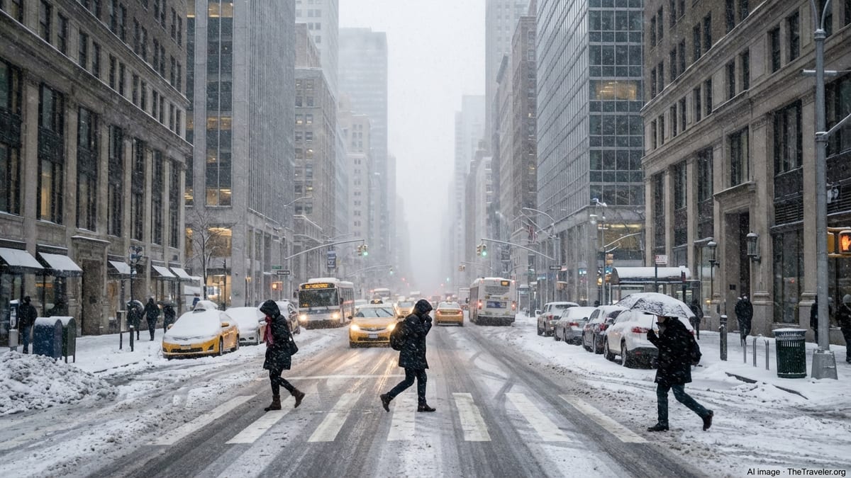
New York City is bracing for its first blizzard warning in nearly a decade as a powerful nor’easter barrels up the East Coast, with forecasters predicting more than a foot of snow, fierce winds and potentially “dangerous, if not impossible” travel from Sunday into Monday.
First Blizzard Warning Since 2017 Marks Rare High-Impact Storm
The National Weather Service has issued a Blizzard Warning for all five boroughs of New York City, along with Long Island and much of coastal New Jersey and southern New England, in effect from 6 a.m. Sunday, February 22, through 6 p.m. Monday, February 23. It is the first time since March 2017 that New York City has been placed under a blizzard warning, underscoring the unusual severity of this late-winter storm.
Meteorologists expect snowfall totals across the city to generally range from 13 to 18 inches, with locally higher amounts possible if the storm’s heaviest snow bands linger over the metro area. Some forecasts indicate there is at least a small chance that parts of the region could approach or even exceed 20 inches, especially across eastern Queens, Brooklyn and Long Island.
Equally concerning are the wind projections, with gusts of 45 to 55 mph expected at the height of the storm Sunday night into Monday morning. Those winds, combined with heavy, powdery snow, are likely to create prolonged whiteout conditions, meeting the technical criteria for a blizzard: winds of at least 35 mph, visibility reduced to a quarter-mile or less and those conditions persisting for three hours or more.
While snowstorms are a familiar part of New York winters, true blizzard conditions are relatively rare. Recent winters have been marked by erratic snowfall patterns, including long stretches with little accumulation punctuated by a few powerful events. This storm, part of the February 2026 nor’easter already being flagged by forecasters as potentially historic for the broader Northeast corridor, is poised to be one of the most significant in years for the city.
Storm Timeline: When Conditions Will Deteriorate
Light snow is expected to begin in the New York City area on Sunday morning, with intensity increasing through the afternoon as the coastal low deepens off the Mid-Atlantic and tracks northeastward. By late afternoon and early evening, forecasters say snow rates could reach 1 to 2 inches per hour, quickly coating roads and reducing visibility.
The most dangerous phase of the storm is projected for Sunday night into early Monday, when the nor’easter is forecast to rapidly intensify just offshore. During this window, snowfall rates may exceed 2 inches per hour in the heaviest bands, while winds ramp up to 30 to 35 mph sustained, with higher gusts. Those overlapping peaks in snow and wind are what have prompted warnings of whiteout conditions.
By Monday morning, the storm’s center is expected to be lifting toward New England, but wraparound snow and strong winds could persist for several more hours. Commuters could wake up to deep drifts, icy sidewalks and limited public transportation options as crews work to dig out the city. Gradual improvement is likely through Monday afternoon as snow tapers to lighter showers and winds slowly ease.
Even after the storm’s main pulse has passed, blowing and drifting snow will remain a concern, particularly in more open areas like coastal Brooklyn, Queens and parts of Staten Island, where gusts will continue to whip loose snow into the air. Temperatures are expected to remain below freezing for much of Monday, limiting melting and extending hazardous conditions on untreated surfaces.
How This Blizzard Compares With Past New York City Snowstorms
For long-time New Yorkers, the looming storm inevitably invites comparisons to past winter benchmarks, from the record-setting blizzard of January 2016 that dropped 27.5 inches in Central Park to the March 2017 event that last triggered a blizzard warning for the city. Early indications suggest this week’s nor’easter may not match the absolute top-tier snow totals of those historic storms, but it may rival them in terms of regional impact.
One key difference is the broader scope of this system. Meteorologists expect heavy snow and blizzard conditions to stretch along a large portion of the Interstate 95 corridor, affecting major population centers from Washington, D.C., and Philadelphia to New York and Boston almost in sequence. That broad footprint may amplify disruptions in air and rail travel, with ripple effects for days.
Another factor is the timing within the season. While February snow is not unusual, a storm of this magnitude arriving so late in the winter calendar is rare. Historical records show that snowstorms producing more than a foot of accumulation this late in February have occurred only a handful of times since the late nineteenth century. That adds to the sense of a high-impact, out-of-the-ordinary event.
Still, experts caution that final totals will depend on subtle shifts in the storm’s track and intensity in the hours before landfall. A jog of even 25 to 50 miles east or west could mean the difference between a top-10 snowfall for the city and a merely significant, though still disruptive, winter storm. For now, forecasters are emphasizing impacts rather than precise inch counts, highlighting the dangerous combination of snow, wind and coastal flooding.
City Prepares: Emergency Declarations, Plows and Transit Changes
City and state officials moved swiftly once confidence grew that the nor’easter would deliver blizzard conditions to the region. New York Governor Kathy Hochul has declared a state of emergency for much of the state, including New York City and Long Island, a step that streamlines the deployment of resources and allows for faster coordination with local governments and utility providers.
Mayor Zohran Mamdani has activated the city’s emergency operations center and ordered agencies onto a storm footing. The New York City Department of Sanitation has issued a snow alert beginning early Sunday morning, signaling a full mobilization of plows, salt spreaders and 12-hour split shifts for thousands of workers. Plows are expected to be pre-positioned at key chokepoints and bridge approaches to keep at least some lanes open for essential travel as the snow intensifies.
Transit agencies are also adjusting plans in anticipation of hazardous conditions. The Metropolitan Transportation Authority has warned riders to prepare for service reductions and possible suspensions on some commuter rail lines, particularly the Long Island Rail Road and Metro-North branches where heavy snow and drifting are most likely. The subway system, mostly underground, is expected to fare better, but elevated lines in outer boroughs are vulnerable to accumulating snow and blowing ice.
On the roads, officials are urging residents to avoid nonessential driving from Sunday afternoon through Monday. Restrictions on certain types of vehicles, including tractor-trailers and buses, are likely on major highways in and around the city as visibility deteriorates. Ride-share companies and delivery services are advising customers to expect delays or temporary pauses in operations during the peak of the storm.
Air Travel Disruptions and Broader Northeast Impact
Airlines have already begun canceling flights at New York’s three major airports, with carriers issuing weather waivers that allow passengers to rebook without change fees. John F. Kennedy International, LaGuardia and Newark Liberty International airports sit squarely in the projected path of the heaviest snow, and aviation experts say that runway closures and cascading delays across the national air network are virtually certain.
Because the same storm is forecast to bring heavy snow to Philadelphia, Providence and Boston as it moves north along the coast, there will be limited options for rerouting flights around the most severely affected hubs. Travelers with scheduled flights from Sunday into Tuesday are being urged to monitor airline alerts closely and, where possible, move travel plans earlier or later to avoid the worst of the disruption.
Amtrak and regional rail services are also preparing for impact. Portions of the busy Northeast Corridor may see reduced schedules or temporary suspensions if snow accumulation interferes with switches, overhead lines or station access. Some bus operators have already announced preemptive cancellations of intercity routes that traverse the I-95 corridor during the height of the storm.
Beyond transportation, the storm’s broad footprint means that utility crews, emergency responders and hospital systems across the Northeast will all be operating under strain at roughly the same time. Coordination between states has ramped up in recent days, with mutual aid agreements and staging areas set up ahead of the first flakes to ensure that extra crews can be shifted swiftly into the hardest-hit communities once the storm passes.
Coastal Flooding and Power Outage Concerns
While the focus for many residents is on snow totals, forecasters and emergency managers are stressing that coastal flooding and power outages may ultimately be the most damaging aspects of this blizzard for some neighborhoods. The nor’easter is expected to generate prolonged onshore winds coinciding with multiple high-tide cycles, raising water levels along the shores of New York Harbor, the Rockaways, southern Brooklyn and parts of Staten Island.
Coastal flood watches and advisories have been issued for portions of the Bronx and northern Queens, with forecasters warning that 1.5 to 2.5 feet of inundation above ground level is possible in vulnerable low-lying areas. Even minor to moderate flooding can make certain shorefront roads impassable, complicating emergency response at the same time that snow-covered inland streets are becoming harder to navigate.
Heavy, wet snow combined with strong winds will also test the resilience of the region’s power grid. Although much of New York City’s electrical infrastructure is underground, significant portions of surrounding suburbs and outer coastal communities rely on aboveground lines that are more susceptible to damage from falling branches and toppled poles. Utilities have brought in extra crews and equipment in advance, but they caution that in the worst-affected zones, power restoration could take many hours or even several days.
Residents in at-risk areas are being advised to charge electronic devices, ensure battery-powered radios and flashlights are working, and prepare to keep homes warm and lit without relying solely on the grid. Officials are also reiterating safety reminders about the dangers of using generators or charcoal grills indoors, which can quickly lead to deadly carbon monoxide buildup.
What Residents Should Do Now to Prepare
With the blizzard warning in effect and the storm’s arrival only hours away, emergency officials say the window for last-minute preparations is quickly closing. New Yorkers are being urged to complete essential errands early Saturday and Sunday morning, including stocking up on nonperishable food, bottled water, medications and any necessary pet supplies enough to last at least several days.
Homeowners and building managers are being reminded of their responsibility to keep sidewalks clear once the snow begins to fall, but officials emphasize that safety comes first. Many are advising residents to shovel in multiple rounds during lulls in the storm, rather than waiting until the end when accumulations may be overwhelming. Applying ice melt before the heaviest snow arrives can help prevent solid sheets of ice from forming underneath drifts.
Drivers who must be on the road are encouraged to keep emergency kits in their vehicles, including blankets, extra clothing, a small shovel, sand or cat litter for traction, and a fully charged phone. Those who rely on medical equipment that requires electricity should check in with their providers and, if necessary, register with local emergency management offices to ensure they are on lists for wellness checks in the event of extended outages.
Above all, officials stress that the safest place to ride out the blizzard will be indoors. Residents are being asked to stay off the streets during the worst of the storm not only for their own protection but to give sanitation and utility crews room to work. Social service agencies are also conducting outreach to bring unsheltered New Yorkers into warming centers and emergency shelters before conditions deteriorate.
Travel, Tourism and the City’s Winter Identity
The blizzard arrives during what is typically a slower but still active period for tourism in New York City, with visitors drawn to museums, indoor attractions and the lingering glow of winter in the parks and on iconic avenues. This weekend, however, many of those plans are being rapidly reshaped as airlines cancel flights, hotels pivot to storm protocols and attractions adjust hours or close temporarily in anticipation of hazardous conditions.
Major cultural institutions and Broadway theaters are monitoring the forecast closely, with some already signaling that Sunday evening performances and events may be canceled or altered if it becomes unsafe for audiences and staff to travel. Hotels across Manhattan and the outer boroughs are preparing to accommodate guests for longer stays if departures are delayed, while also ensuring they have adequate staffing levels and supplies if employees are unable to commute.
For the city’s hospitality sector, the storm is a mixed blessing. Images of a snow-blanketed skyline and a hushed, car-free Times Square are likely to circulate widely on social media and in news coverage, feeding the longstanding romantic association between New York and winter weather. At the same time, prolonged travel disruptions and the possibility of power outages or flooding could pose significant short-term challenges for small businesses, restaurants and neighborhood shops already operating on tight margins.
In the longer view, this latest blizzard reinforces New York’s evolving winter identity in an era of climate volatility, where quieter seasons can suddenly be punctuated by intense, high-impact storms. For residents and visitors alike, the coming days will offer a vivid reminder of both the city’s vulnerability to the forces of nature and its capacity to adapt, dig out and get moving again once the skies finally clear.