
Ontario stretches from the busy streets of Toronto to remote tundra on the shores of Hudson Bay, tying together big-city culture, cottage-country lakes and some of Canada’s most dramatic wilderness. For travelers, it offers a rare combination: world-class museums and food scenes within a day’s drive of quiet canoe routes, thundering waterfalls and boreal forest where cell service simply drops away. This guide outlines how to experience the province’s urban highlights, lake country and vast northern landscapes, with practical advice on when to go and how to plan a trip that matches your time, budget and appetite for adventure.
Understanding Ontario’s Scale and Seasons
Ontario is Canada’s second-largest province, and distance shapes almost every trip here. It takes roughly 14 to 16 hours to drive from Windsor in the southwest to Thunder Bay on the north shore of Lake Superior, and another full day of travel to reach the remote communities on Hudson Bay. Most visitors focus on the more populated south, home to Toronto, Ottawa, Niagara and the popular cottage-country regions. Those with extra time venture north along Lake Superior or into inland parks where roads thin out and towns sit hundreds of kilometres apart. Building realistic driving times into your itinerary is essential, especially in winter when storms can slow travel.
Ontario has four pronounced seasons, and each changes what you can see and how you travel. Summers from late June through August tend to be warm to hot in the south, with comfortable nights in cottage country and cooler days along Lake Superior. This is peak season for festivals, patios and swimming in the lakes. Winter typically runs from December through March, with reliable snow across much of the province and very cold temperatures in the north, ideal for skiing, snowshoeing and northern lights viewing. Spring and autumn are shoulder seasons, quieter and often more affordable, though weather can swing quickly between warm sun and frost.
Many travelers plan their Ontario visit around seasonal highlights. In September and early October, Algonquin Provincial Park and the Muskoka region are famous for blazing fall colours along forested shorelines, often mirrored in glassy lakes. In May and June, southern Ontario sees migrating birds move through wetlands and forests, drawing birders to areas such as Presqu’ile Provincial Park and the shores of Lake Erie. Winter visitors target ski areas around Collingwood, snowmobile trails in cottage country and the possibility of seeing the aurora in northern communities, where dark skies and cold, clear nights create strong viewing conditions.
Weather can vary significantly between southern cities and the north, so packing layers is important. Summers in Toronto often feel humid, while the breeze off Lake Superior can be cool even in July. In winter, major highways are well maintained, but road closures and whiteout conditions still occur. Checking forecasts and road reports before long drives is advisable, especially if you are unfamiliar with driving in snow or on icy surfaces. In northern wilderness areas, weather shifts quickly, so backcountry travelers should be prepared for rain and colder temperatures even during the warmest months.
Toronto and the Golden Horseshoe
Toronto, Canada’s largest city, is usually the entry point to Ontario and anchors what is known as the Golden Horseshoe, the urban and industrial arc that curves around the western end of Lake Ontario. The city’s skyline of glass towers and its dense downtown core contrast with its older brick neighbourhoods and long waterfront. Travelers split time between cultural institutions, neighbourhood exploring and day trips out of the city. The downtown area is walkable and well served by public transit, which makes it simple to combine visits to the major museums, food markets and waterfront parks without a car.
Culturally, Toronto is one of the most diverse cities in North America, and that shows most clearly in its food scenes and street life. Immigrant communities have shaped neighbourhoods from Little Italy and Greektown to Chinatown, Koreatown and pockets of Caribbean and South Asian culture. For visitors, this means you can eat very well at almost any budget, with everything from small family-run restaurants to tasting-menu kitchens led by high-profile chefs. Museums and galleries showcase Canadian and international art, natural history, film and design. Live music, theatre and sports, including hockey and basketball, give the city an energy that carries well into the night, especially in summer.
Beyond the core, the Greater Toronto Area includes smaller waterfront cities such as Hamilton and Oshawa, suburban communities, and green spaces that break up the urban development. Rouge National Urban Park, on the northeastern edge of the city, protects a swath of forests, wetlands and farmland along the Rouge River valley. It offers hiking trails, beaches and wildlife viewing within the metropolitan area, a rarity for a city of this size. West of Toronto, the Niagara Escarpment rises from the plains and creates a band of cliffs and forests that define the landscape all the way to the Bruce Peninsula, offering hiking and viewpoints within reach on a single-day drive.
Practical planning for Toronto often focuses on timing and transport. Summer festivals, major concerts and sports events can strain hotel capacity and push prices up, while winter can be more affordable. The city center is linked by frequent trains and buses to nearby communities, including Niagara Falls and Kingston, so travelers without cars can still explore beyond the core. Renting a car becomes more useful when you want to venture into wine regions around Niagara, small towns along Lake Ontario, or the escarpment trails outside the reach of local transit.
Capital Routes: Ottawa, Kingston and the Rideau Corridor
East from Toronto, the corridor along Highway 401 leads to Kingston and Ottawa, opening a softer, more historic side of Ontario. Kingston, located where Lake Ontario narrows into the St. Lawrence River, once served as Canada’s capital and still wears its 19th-century limestone architecture proudly. Its compact downtown is easy to explore on foot, with waterfront parks, courtyards and patios spilling out in summer. The nearby Thousand Islands region, scattered where the St. Lawrence widens, is known for boat tours among forested islets and for quiet waterfront cabins hidden in coves and channels.
North of the St. Lawrence sits Ottawa, Canada’s capital, on the banks of the Ottawa River. Parliament Hill, federal museums and galleries, and national cultural institutions shape the city, but it is smaller and more relaxed than Toronto. The downtown core hugs the river and the historic ByWard Market area, where restaurants, cafés and stalls cluster in restored brick buildings. During winter cold snaps, part of the Rideau Canal that runs through the city often transforms into a long natural skating route when conditions allow, a signature seasonal experience that draws both locals and visitors.
The Rideau Canal continues south from Ottawa through lakes and rivers linked by historic locks before joining the St. Lawrence near Kingston. This corridor, with small communities, farms and forest along its shores, is popular for leisurely boating, paddling and cycling during the warmer months. Many travelers choose to spend a night or two along the canal, combining short hikes with lock-side picnics and visits to heritage sites. The pace here contrasts with that of the big cities and gives a glimpse into rural Ontario where tourism, agriculture and cottage life intersect.
Traveling between Toronto, Kingston and Ottawa is straightforward by highway, bus or train. Rail services connect the major cities on this route, making it possible to plan a car-free itinerary that still includes lakeside walks and time on the water. Renting a car provides more flexibility to detour into small towns and conservation areas off the main line. As with the rest of the province, midsummer brings the heaviest crowds, while late spring and early autumn often offer clear weather, fewer visitors and vivid colours along the forests that frame roadways and waterways.
Lakes, Cottages and Classic Ontario Outdoors
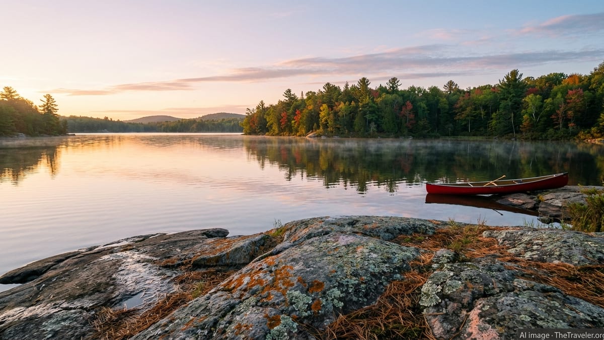
North of the urban corridor, rock and forest begin to dominate and the province’s famous cottage country unfolds. The Muskoka region, the Kawarthas and the Haliburton Highlands are dotted with lakes of all sizes, connected by rivers and backroads and fringed with mixed forest. For generations, families from southern Ontario have spent summers here in cottages and cabins, so travelers find a well-developed network of lodges, rental properties and campgrounds. The classic experience in these regions is simple: swimming off a dock, paddling at sunset, listening to loons call across still water and watching campfire sparks rise into the dark.
Algonquin Provincial Park, established in the late 19th century and stretching across thousands of square kilometres, is the signature protected area in this belt of land. The park lies between Georgian Bay and the Ottawa River and serves as a transition zone between northern conifer forests and southern deciduous woods. More than two thousand lakes, plus rivers and wetlands, create a rich habitat for wildlife including moose, beavers, black bears and wolves. Visitors often base themselves along the Highway 60 corridor on the park’s south side, where campgrounds, short hiking trails, visitor centres and viewpoints make the park accessible even to first-time campers.
Beyond the road-accessible areas, Algonquin is renowned for canoe routes that weave from lake to lake through portages, with simple backcountry campsites on shorelines and islands. Trips can range from a single overnight loop to multi-day expeditions deep into quieter sections of the park. Paddlers should be comfortable with map reading, basic navigation and wilderness camping, and should pack for quickly changing weather, especially in spring and autumn. For those who prefer day activities, the park’s interpretive trails explain its geology, logging history and ecology, and viewpoints over lakes and hills are reachable on relatively short hikes from the main road.
Elsewhere in cottage country, smaller provincial parks and conservation areas offer more compact, less crowded experiences. Queen Elizabeth II Wildlands and other protected tracts safeguard a patchwork of wetlands, granite ridges and small lakes, many without formal facilities. Here, travel is more self-reliant and often suited to experienced hikers and paddlers comfortable with limited signage and rougher put-ins. Wherever you go in this region, summer weekends are busy, and reservations for campsites and popular lodges are essential. Shoulder-season visits in June or September can offer quieter lakes, fewer insects and cooler nights, at the cost of more variable weather.
Lake Superior and the Call of the North Shore
Farther north and west, the landscape hardens again as you approach Lake Superior, the largest of the Great Lakes by surface area and one of the dominant geographic features of Ontario. The Trans-Canada Highway skirts its northern shore, linking Sault Ste. Marie and Thunder Bay with long stretches of pavement that wind between cliffs, boreal forest and vistas over cold, steel-blue water. This is one of the most scenic drives in eastern Canada, with roadside lookouts, trailheads and small towns offering chances to step out and explore the shoreline on foot.
Provincial and national parks along the Superior shore preserve some of its wildest sections. Pukaskwa National Park, for example, protects rugged coastlines, pebble beaches and mixed forest, and is known among hikers for its demanding multi-day coastal trail and shorter routes to suspension bridges and waterfalls. Inland from the shore, smaller parks and protected areas encompass canyons, inland lakes and rivers feeding the big lake. Even in midsummer, the water of Lake Superior stays cold, but beaches and day-use areas become popular with picnickers and campers who come for the combination of wind-shaped pines, lichen-covered rock and endless horizon.
Thunder Bay, the main urban centre in northwestern Ontario, serves as a gateway to both the Superior shore and the inland lakes and forests that stretch toward Manitoba. The city’s working port, historic sites and nearby viewpoints give context to the scale of the lake and the history of trade and settlement in this part of Canada. From here, travelers can continue west toward the Prairies, loop inland toward remote canoe routes, or turn back south along the lake. Services such as accommodations and fuel are concentrated in the larger towns, so planning refuelling and overnight stops carefully is wise, particularly outside peak summer months when some seasonal businesses close.
Driving the north shore rewards slow travel. Distances between major communities are considerable, and many of the finest experiences come from unplanned stops at short trails or small beaches visible from the highway. Wildlife sightings are common, including moose and black bears near the roadside, so drivers should be alert at dawn and dusk. Fog off the lake, sudden storms and winter squalls are part of the Superior story, and travel plans need enough flexibility to account for delays. In return, visitors gain access to a landscape that feels both immense and intimate, with small coves and islands breaking up a seemingly limitless expanse of water.
Deep Wilderness and the Far North
Beyond the north shore of Lake Superior, Ontario stretches into a vast interior of forest, rivers and tundra that sees far fewer visitors. Large wilderness parks, including Wabakimi and Polar Bear Provincial Park, protect remote watersheds and wildlife habitat across hundreds of thousands of hectares. Access to these areas is often by train, floatplane or chartered boat, and facilities are minimal or entirely absent. For experienced paddlers and wilderness travelers, these northern parks represent some of the most remote adventure opportunities in eastern North America, with long canoe routes, world-class fishing and rare chances to experience intact boreal and subarctic ecosystems.
The far north along Hudson Bay and James Bay is one of the least developed coastal regions in Canada. Communities here are primarily Indigenous, and travel often involves coordination with local operators or guides. Polar Bear Provincial Park, for instance, is managed as a strict wilderness area without roads or visitor services. Its primary purpose is to protect sensitive wetlands and the polar bears that migrate along the coast, so access is tightly controlled and requires advance permission, careful planning and a high level of self-sufficiency. Weather is severe and changeable, and visitors must be prepared for delays in flights and challenging conditions on the ground.
Inland, the shield country north of Lake Superior combines dense forest, muskeg, rivers and lakes in a labyrinth that supports remote lodges, outpost cabins and fly-in fishing camps. Travel here is expensive compared with road-accessible regions but offers solitude and dark night skies rarely found farther south. Trip planning in these regions must account for limited emergency services, patchy communications and the need to pack all essential supplies. Working with reputable outfitters and local guides is strongly recommended, particularly for first-time visitors to the northern boreal or tundra environments.
While the far north appeals mainly to dedicated wilderness travelers, its presence shapes the identity of Ontario as a whole. Even if you stay closer to the southern cities and lakes, you will see references to the north in art, literature and everyday conversation. For many residents, the idea of retreating to a cabin or heading “up north” for a long weekend is central to how they relate to the landscape. Understanding that connection can enrich your own trip, whether your northernmost stop is a lakeside town or a remote river reached only after hours in a small plane.
Practical Planning, Transport and Responsible Travel
Ontario is typically reached by air through major airports in Toronto and Ottawa, with additional international and domestic flights into smaller cities such as London, Hamilton and Thunder Bay. Once on the ground, most travelers rely on a mix of rental cars, intercity buses and rail to move between regions. In southern Ontario, trains link major cities along the Windsor–Toronto–Ottawa–Montreal corridor, and buses fill in many of the gaps to mid-sized towns. North of the main corridor, rail and bus options thin out, and driving becomes the most flexible way to explore lakes, small communities and trailheads.
Driving conditions vary throughout the year. In summer, road construction can cause delays on busy routes, particularly near cities, while in winter, heavy snow and ice affect northern highways and even some major southern arteries. Renting a vehicle with good tires and sufficient ground clearance is useful if you plan to travel rural roads or visit parks with gravel access roads. Fuel stations can be far apart in northern sections of the Trans-Canada Highway and in some cottage-country areas after dark, so keeping the tank topped up is a wise habit. In cities, parking can be expensive and hard to find near popular attractions, encouraging the use of public transit or taxis.
Entry requirements for Canada and internal travel rules are subject to change, so international visitors should confirm current regulations with official government sources before departure. Within Ontario, provincial parks and national parks use reservation systems for many drive-in and backcountry campsites, especially in high-demand areas such as Algonquin and along Lake Superior. These reservations often open months in advance and can sell out quickly for popular summer weekends. Checking opening dates and booking early can make the difference between securing a lakefront site and having to reroute your trip.
Responsible travel is an important theme across Ontario, particularly in heavily visited natural areas. Standard Leave No Trace principles apply: pack out what you pack in, minimize campfire impacts, stay on marked trails where requested and respect wildlife by observing from a distance and never feeding animals. Black bears, moose and smaller mammals are part of the landscape, and proper food storage in campgrounds and backcountry sites reduces the chance of negative encounters. In urban settings, supporting local independent businesses, galleries and cultural organizations helps sustain the communities that give Ontario its character.
Choosing Your Ideal Ontario Itinerary
Because Ontario is so large and varied, most travelers will only sample a few regions on a single trip. A first-time visitor with a week might focus on Toronto, Niagara Falls and a short stay in cottage country, combining city culture with lake time and one or two hikes in a provincial park. With 10 to 14 days, you could add Ottawa and Kingston, include a boat trip in the Thousand Islands, or drive a loop that links Toronto, Algonquin Provincial Park, Ottawa and back through the Rideau corridor. Travelers with three weeks or more can reach the north shore of Lake Superior, giving them a deeper sense of Ontario’s wild side.
Your interests should shape your route. For food, museums and nightlife, Toronto and Ottawa can easily fill several days each. For paddling, camping and wildlife, Algonquin, the Kawarthas, Muskoka and the Haliburton Highlands offer accessible choices, while more experienced travelers might look at remote canoe routes in Wabakimi or smaller wilderness parks. Those drawn to road trips and big lakes might prioritize the drive between Sault Ste. Marie and Thunder Bay, supplemented with day hikes and nights under canvas or in simple lakeside cabins.
Seasonality is another key factor in itinerary design. Families bound by school holidays often target midsummer, accepting higher prices and busier beaches in exchange for reliable warmth and long daylight hours. Couples and solo travelers with flexible schedules may prefer late May to June or September to early October, when bugs typically ease, evenings are cooler and forests glow with new leaves or autumn reds and golds. Winter specialists, from cross-country skiers to ice climbers, build itineraries around snow conditions, frozen lakes and the limited daylight of December and January, making sure to budget extra time for travel disruptions from storms.
Whatever shape your trip takes, it helps to anchor your plan with a few key experiences rather than trying to see everything. A city neighbourhood walk guided by a local, a sunrise paddle on a misty lake, a train ride along a river or a simple evening spent watching the sky darken over Lake Superior can all define an Ontario journey. Giving yourself time to slow down, linger and adapt to the rhythm of each place often leads to the most memorable encounters, whether that is a conversation with a café owner in a small town or the sudden appearance of a moose on the far shore of a quiet bay.
FAQ
Q1. How many days do I need to see the main highlights of Ontario?
Most first-time visitors spend 7 to 10 days, which allows time for Toronto, a day trip to Niagara Falls and two to four days in cottage country or Ottawa.
Q2. When is the best time of year to visit Ontario?
July and August are warm and lively, while late September and early October offer striking fall colours. May, June and September are often good for fewer crowds.
Q3. Do I need a car to travel around Ontario?
You can visit major cities by train and bus, but a car is very useful for reaching lakes, provincial parks, small towns and viewpoints along the Lake Superior and cottage-country routes.
Q4. Is it safe to camp in Ontario’s parks with wildlife nearby?
Yes, if you follow park guidelines. Proper food storage, clean campsites and respecting distance from animals greatly reduce the risk of negative encounters with bears or other wildlife.
Q5. How cold does it get in Ontario during winter?
In southern cities, winter temperatures often dip below freezing, while northern regions can experience much colder conditions. Wind and storms can make it feel significantly colder.
Q6. Can I see the northern lights in Ontario?
Northern lights are occasionally visible, particularly in northern Ontario, on clear, dark nights. Activity varies, so there is never a guarantee, but winter and early spring can offer better chances.
Q7. Are there good options for short hikes rather than multi-day treks?
Yes. Many provincial and national parks, including Algonquin and those along Lake Superior, have signed day trails ranging from easy lakeside walks to moderate ridge and waterfall hikes.
Q8. How far in advance should I reserve campsites in popular parks?
For summer weekends in well-known parks, it is wise to book as soon as reservations open, often several months ahead. Weekdays and shoulder seasons may offer more flexibility.
Q9. Is Ontario a good destination for families with children?
Yes. Cities offer museums, aquariums and sports events, while lakeside regions provide safe swimming areas, easy hikes and wildlife viewing opportunities that appeal to a wide range of ages.
Q10. What is the takeaway for planning an Ontario trip?
Recognize the province’s size, choose a few regions that match your interests, account for seasons and travel times, and build in unhurried days to enjoy both its cities and wild places.