
Phnom Penh can feel disorienting when you first arrive. Streets are numbered but not always sequential, the city has grown far beyond its historic core, and three rivers meet at the heart of town.
Once you understand how the districts align around the Tonle Sap and Mekong Rivers and where the main attractions sit on the map, Phnom Penh becomes much easier to navigate. This guide breaks down the city’s layout, explains the key urban districts, and shows how the famous riverfront ties it all together.
Getting Oriented: How Phnom Penh Is Laid Out
Phnom Penh is Cambodia’s capital and largest city, an autonomous municipality divided into 14 administrative districts known as khans. These khans stretch from the historic center around the Royal Palace and Wat Phnom out to new residential zones, industrial estates, and peri-urban farmland. The older districts are compact and walkable, while the outer districts sprawl along major highways on the way to provincial Cambodia.
The city’s basic shape is defined by water. To the east, the Mekong River flows south toward Vietnam. The Tonle Sap River runs roughly north to south through the city and meets the Mekong just downstream from the historic center. To the northeast, the Tonle Sap continues toward the great Tonle Sap Lake. This confluence happens in front of the Chroy Changvar peninsula, a long sliver of land that splits the rivers and frames Phnom Penh’s skyline from across the water.
In practical terms, the rivers and a few key boulevards form your reference points. Norodom Boulevard and Monivong Boulevard run roughly north to south, lined with government offices, banks, hotels, and embassies. Perpendicular to them, major roads such as Sihanouk, Mao Tse Toung, and Russian Federation Boulevards cut west toward the airport and the city outskirts. If you imagine a rough crosshairs with Wat Phnom and the Central Market near the center, you can mentally plot the districts around that point.
Most visitors will spend their time in three or four central districts, all within a short drive of one another. These are Chamkar Mon, Doun Penh, Boeng Keng Kang, and Prampir Makara. River-oriented travelers will also want to remember Chroy Changvar and Chbar Ampov across the water. Beyond them, districts such as Tuol Kouk, Sen Sok, Russey Keo, Dangkao, Pou Senchey, Prek Pnov, Mean Chey, and Kamboul make up the broader metropolitan area.
The Central Core: Doun Penh and the Historic Heart
Doun Penh is the historic and symbolic center of Phnom Penh. It covers the area around Wat Phnom, from which the city takes its name, and stretches south to the Royal Palace and National Museum. If you imagine a classic postcard of Phnom Penh, with a gilded palace roofline and boats on the river, you are looking at Doun Penh.
This district is dense with landmarks. Wat Phnom sits at the northern end of Norodom Boulevard on a small artificial hill, surrounded by mature trees and legend. Just south lie the Central Market, with its striking art deco dome and radiating market halls, and the bustling streets of the old commercial quarter. The Royal Palace complex occupies prized riverfront land, sharing the neighborhood with the silver-floored Silver Pagoda and manicured gardens. The National Museum, in a red sandstone-inspired structure, stands a block behind the riverfront road.
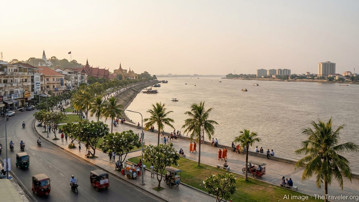
The riverfront itself, Sisowath Quay, forms the eastern boundary of Doun Penh along the Tonle Sap River. This three-kilometer promenade is one of the most important orientation lines on the map. On the city side of the boulevard, low-rise shop houses, hotels, and restaurants face the river, while on the water side open plazas and pathways create space for joggers, street vendors, and festival crowds. From here you can see across to Chroy Changvar and the point where the rivers meet.
Because of its role as civic and cultural core, Doun Penh is also where you will encounter some of Phnom Penh’s busiest intersections. Norodom Boulevard slices through the district from north to south, while smaller numbered streets form a rough grid, although not always as regular as it looks on paper. Grasping that Doun Penh is essentially the “old city” surrounded on three sides by other districts and on one side by the river helps you visualize how the rest of Phnom Penh has grown outward.
Chamkar Mon, Boeng Keng Kang and the Southern City
South of the Royal Palace, the city transitions into a mix of embassies, leafy side streets, and popular neighborhoods for dining and nightlife. Chamkar Mon district covers a large swath of this area, while Boeng Keng Kang, previously part of Chamkar Mon, now forms its own compact central district. For travelers, these names matter because they correspond to many hotel listings and local references.
Boeng Keng Kang, often shortened to BKK, has in recent years become shorthand for Phnom Penh’s modern, international side. The BKK1 neighborhood in particular is dense with cafes, co-working spaces, international restaurants, serviced apartments, and small boutiques. Streets here turn into a checkerboard between Norodom and Monivong Boulevards, making it relatively easy to orient yourself. Walking distances between coffee shops, rooftop bars, and guesthouses are short, although traffic can still be intense at rush hour.
Chamkar Mon surrounds Boeng Keng Kang and stretches farther south, taking in parts of the riverside south of the palace as well as famous city landmarks like the Independence Monument. The monument itself, with its lotus-shaped spire, stands at the junction of Norodom and Sihanouk Boulevards and operates as another key anchor on the mental map. To the south and east you will find river-hugging developments on Koh Pich, or Diamond Island, and new bridges linking to emerging neighborhoods across the water.
When you look at a map, notice that Chamkar Mon and Boeng Keng Kang sit just to the west of the Tonle Bassac and Mekong Rivers, with bridges connecting them to Chbar Ampov and the southern edges of the city. This is also where several of Phnom Penh’s most prominent shopping malls and mixed-use developments are rising, creating a southward pull for both residents and visitors. Thinking of Chamkar Mon and Boeng Keng Kang as the city’s “southern downtown” will help you understand why so many accommodation listings cluster here.
Tuol Kouk, Prampir Makara and the Western Grid
To the west of the historic core, Phnom Penh spreads out into residential and commercial districts punctuated by busy roundabouts and flyovers. Two names appear frequently in local directions: Tuol Kouk and Prampir Makara. Both are part of the inner city, but they feel different from the riverside, with more Cambodian-style townhouses, campuses, and markets than tourist hotels.
Prampir Makara, also known as 7 Makara, sits immediately west of Doun Penh and is the smallest district by land area but the most densely populated. It contains Orussey Market, a major wholesale and retail hub where buses, trucks, and motorbikes converge around textile stalls and hardware shops. On the map, Prampir Makara is framed by some of the city’s key radial roads, including Russian Federation Boulevard heading toward the airport and Kampuchea Krom Boulevard leading west to other provinces.
Further northwest, Tuol Kouk covers a wide area of mid-rise housing, office blocks, and schools. Its grid of streets, combined with several large boulevards, makes it a clear reference point when you book accommodation advertised as being “in the city but away from the tourist center.” Development here is more spread out, and attractions tend to be local rather than iconic, but the district’s location means it is often on the way between the center and the airport or the northern suburbs.
On a city map, Tuol Kouk and Prampir Makara form the western anchor that balances Doun Penh and the riverfront. Russian Federation Boulevard runs between them and the airport, while the 7 Makara Sky Bridge and other flyovers help funnel traffic. For visitors using the public bus network, many bus lines converge on these streets, making western districts practical stepping stones even if they are not your final destination.
The Riverfront: Sisowath Quay and Beyond
For many travelers, the easiest way to grasp Phnom Penh’s geography is to start at the river. Sisowath Quay traces the western bank of the Tonle Sap River through the center of the city, and for orientation purposes you can think of it as the “front door” of Phnom Penh. Running roughly north to south for about three kilometers, it links the area around Wat Phnom to the Royal Palace and then continues toward the junction with the Bassac River.
The riverfront promenade is wide, with pockets of grass and paved plazas that open onto views of the water. In the morning, joggers and tai chi practitioners take advantage of the cooler air, and monks in saffron robes pass on their alms rounds. By late afternoon and evening, the promenade fills with families, street vendors selling iced coffee and fresh fruit, and aerobics classes broadcast through portable sound systems. Locals and visitors alike sit on the low walls to watch boats, sunsets, and festival fireworks.
Lining the land side of the quay are hotels, guesthouses, bars, and restaurants, many with balconies or rooftop terraces overlooking the river. While Phnom Penh has grown upward in other areas, building heights along most of Sisowath Quay remain modest, allowing light and breeze to reach the street. This strip is also home to longstanding institutions such as riverfront cafes, small galleries, and travel agencies that have helped generations of visitors organize onward journeys.
Recent years have seen portions of the riverfront designated as pedestrian-focused areas on weekend evenings, especially during events and public holidays. Sections of the road are closed to through-traffic, turning the quay into a temporary walking street lined with food stalls and pop-up entertainment. Mapping apps may not always reflect these short-term closures, but for visitors they add another layer of life to the already vibrant promenade and reinforce Sisowath Quay’s role as the city’s communal living room.
Across the Water: Chroy Changvar and Chbar Ampov
Understanding Phnom Penh’s map means looking not just at the west bank of the rivers but also at the districts across the water. Chroy Changvar lies to the northeast of the city center on a peninsula between the Mekong and Tonle Sap Rivers. It is connected to the rest of Phnom Penh by bridges that cross the Tonle Sap close to Wat Phnom and the northern end of Sisowath Quay.
From the riverfront in Doun Penh, Chroy Changvar forms part of the skyline view, with newer residential compounds, hotels, and riverfront promenades of its own. For travelers, it offers a quieter vantage point on the city, with easy access back across the bridges to the historic center. The peninsula’s long, thin shape is clear on any map and makes a good reference marker: if you see it, you know you are looking roughly north.
To the southeast, Chbar Ampov district sits on the east bank of the Bassac River, connected to Chamkar Mon and Boeng Keng Kang by the Monivong Bridge and other newer crossings. Historically a more rural fringe of Phnom Penh, Chbar Ampov has seen rapid growth, with housing estates, schools, and markets lining the main roads that lead out of the city. River views and proximity to the center are now drawing more residents to this side of the water.
When you study a map of Phnom Penh, it helps to think of the rivers as axes along which the city has expanded. The traditional core lies on the west bank, but bridges have turned Chroy Changvar and Chbar Ampov into extensions of the urban fabric. Boat cruises often depart from piers along Sisowath Quay and head around these areas, giving you a literal overview of the city’s layout while you glide along the confluence of the Tonle Sap and Mekong.
Outer Districts, New Developments and How the City Sprawls
Beyond the inner ring of central districts, Phnom Penh’s remaining khans form a broad outer belt. Names like Russey Keo, Sen Sok, Dangkao, Pou Senchey, Mean Chey, Prek Pnov, and Kamboul rarely appear on short-stay itineraries, but they are fundamental to understanding how the city actually functions. They are where many of Phnom Penh’s residents live, work in factories or warehouses, and commute from each day.
To the north and northwest, Russey Keo, Prek Pnov, and Sen Sok encompass a patchwork of residential zones, industrial parks, and remaining farmland. Major roads and ring roads carve across this part of the map, connecting Phnom Penh with provincial highways. The city bus network, expanded significantly in recent years, now runs more than 20 routes across these districts, typically linking them back to key central nodes such as the Old Stadium, Central Market, Aeon Mall complexes, and major intersections.
South and west of the center, Dangkao, Kamboul, Pou Senchey, and parts of Mean Chey spread along trunk roads and peri-urban corridors. The international airport sits within this western zone, and development has followed the highways that radiate from it. Warehousing and logistics hubs, large garment and footwear factories, and gated housing projects cluster along these routes, reinforcing the sense that Phnom Penh’s growth is stretching toward the provinces rather than upward in the core alone.
From a traveler’s perspective, these outer districts are most relevant as transit spaces. You will likely pass through them on the way to and from the airport, or when visiting destinations outside the city. However, they also host some of Phnom Penh’s fastest-changing landscapes, where new ring roads, bridges, and satellite developments are reconfiguring how the whole city moves. Keeping an eye on the names of these districts on a digital map can offer clues about where Phnom Penh is headed in the coming years.
Attractions on the Map: From Royal Palace to Killing Fields
Plotting Phnom Penh’s main attractions on a map reveals how compact the core really is. The Royal Palace and the National Museum anchor the Doun Penh riverfront, only a short walk apart. Wat Phnom lies a little to the north along Norodom Boulevard. The Central Market and the nearby Sorya Market complex sit inland but remain only a few minutes by tuk-tuk from the river. Independence Monument and its surrounding park, in Chamkar Mon, are a short ride to the south.
Other significant sites spread into adjacent districts but remain well within the urban grid. The Tuol Sleng Genocide Museum, located in the former S-21 security prison, stands in a quiet residential zone of Chamkar Mon, west of Norodom Boulevard. The Russian Market, known locally as Tuol Tompoung, is also in the southern city, within the same general area. These sites are usually linked in visitor itineraries because they sit only a short drive from one another, and they connect easily back to the riverside and Boeng Keng Kang neighborhoods.
The Choeung Ek Genocidal Center, often referred to as the Killing Fields, lies further out in the southern outskirts, beyond the core grid. It falls into the rural-urban fringe of the city, accessible via a 30 to 45 minute drive depending on traffic. On the map, you will see this journey taking you through Chamkar Mon and into the outer districts, with the landscape gradually turning from dense shop houses to open fields and clusters of roadside businesses.
Smaller but evocative attractions also dot the city map. Pagodas and shrines appear on many street corners. Markets such as Orussey, Olympic, and Boeung Keng Kang offer glimpses of daily life in different neighborhoods. New developments on Koh Pich and along the Bassac River offer riverwalks, cafes, and views back toward the historic skyline. By studying where each of these places sits in relation to the river and the main boulevards, you can quickly build a mental map that makes it easier to improvise your days in Phnom Penh.
Getting Around: Reading the Map by Street and Bus
Navigation in Phnom Penh combines formal addressing and lived practice. Many streets are numbered rather than named, particularly in central districts, with parallel streets sharing similar number ranges. On maps, you will see smaller streets listed as Street 19, Street 240, or Street 51, for example. Locals often refer to them simply as “Street 51” rather than using Khmer names, which makes it easier for visitors to match spoken directions to digital or printed maps.
Major boulevards, however, do carry widely used names. Norodom Boulevard, Monivong Boulevard, Sihanouk Boulevard, and Russian Federation Boulevard all appear clearly labeled on maps. These long, straight roads are useful orientation lines: if you know which one you are on, you can usually work out whether you are moving toward the river or away from it. Bridges such as the Cambodian-Japanese Friendship Bridge near Wat Phnom or the Monivong Bridge to the south mark key crossing points to the eastern districts.
Phnom Penh’s city bus network has grown into a useful secondary tool for understanding the map. With more than 20 lines, including recent extensions added in 2023 and 2024, buses now connect outer districts such as Prek Pnov, Sen Sok, and Ta Khmao with core areas like Central Market, Wat Phnom, and major malls. While many visitors still rely on tuk-tuks and ride-hailing apps, checking bus route maps can highlight how locals move through the city and where the main corridors run.
For most short stays, however, the simplest approach combines a map app with the city’s visual cues. If you can see the river, you know you are at the eastern edge of the core. If you are on a broad boulevard lined with government buildings or banks, you are probably on Norodom or Monivong. If market stalls crowd the sidewalk under a distinctive dome or multi-story concrete block, you may be at Central Market or Orussey Market. Layering these impressions over what you see on a map quickly makes the city legible.
The Takeaway
Phnom Penh’s map reflects a city shaped by rivers, history, and rapid growth. At its center, Doun Penh gathers royal compounds, museums, markets, and the atmospheric sweep of Sisowath Quay. Just to the south and west, Chamkar Mon, Boeng Keng Kang, Tuol Kouk, and Prampir Makara host embassies, apartments, schools, and a rising skyline of malls and offices. Across the water, Chroy Changvar and Chbar Ampov extend the urban footprint along the Mekong and Bassac, while the outer districts absorb the factories, warehouses, and new suburbs of a capital still expanding.
For travelers, understanding this structure is less about memorizing district names and more about orienting yourself to the rivers and the main boulevards. Start at the riverfront, trace the flow of the Tonle Sap and Mekong, and note where bridges and highways intersect. Add in the positions of the Royal Palace, Wat Phnom, Central Market, and the Tuol Sleng Genocide Museum, and you will have a framework that makes the rest of the city easier to read.
Once you see how the map is organized, Phnom Penh ceases to feel like a confusing sprawl and instead becomes a series of distinct zones, each with its character and rhythm. From the colonial facades and promenades of the riverside to the dense markets and new townships in the west and south, the city invites you to explore not just individual sights, but the connective tissue of streets and districts that link them together.
FAQ
Q1. Which district should I focus on if I am visiting Phnom Penh for the first time?
First-time visitors usually focus on Doun Penh for historic sites and the riverfront, plus Boeng Keng Kang and Chamkar Mon for dining, nightlife, and a wide range of accommodation. These districts cluster around the Royal Palace, Sisowath Quay, and Independence Monument, making it easy to reach most major attractions.
Q2. How do I find Sisowath Quay on the map?
Sisowath Quay runs along the west bank of the Tonle Sap River in the central city. Look for the strip of road directly in front of the Royal Palace and the National Museum and continuing north toward Wat Phnom. It will appear as a long, riverside boulevard parallel to the water.
Q3. Are Phnom Penh’s districts important for booking accommodation?
Yes, because many hotels and guesthouses identify themselves by district and neighborhood. Knowing that Doun Penh is the historic core, Boeng Keng Kang is a modern, cafe-filled area, and Chamkar Mon covers much of the southern downtown helps you choose a location that matches your priorities for sightseeing or nightlife.
Q4. How far are the Killing Fields from the city center?
The Choeung Ek Genocidal Center, often called the Killing Fields, lies on the southern outskirts of Phnom Penh. From the riverfront or Boeng Keng Kang, it typically takes 30 to 45 minutes by car or tuk-tuk, depending on traffic. On a map, you will see it positioned well beyond the dense urban grid in a more rural-urban fringe.
Q5. Is it easy to walk between major attractions in the center?
Many central attractions sit within a compact area, making walking feasible in cooler parts of the day. The Royal Palace, National Museum, riverfront, Wat Phnom, and Central Market can all be reached on foot if you are comfortable crossing busy streets. For sites further out, such as Tuol Sleng or the Russian Market, using tuk-tuks or ride-hailing services is more practical.
Q6. How can I use the rivers to orient myself in Phnom Penh?
The Tonle Sap River runs through the city and meets the Mekong just downstream from the center. If you face the riverfront along Sisowath Quay, Chroy Changvar lies across the water to the northeast, while the Royal Palace and central districts are behind you to the west. The rivers effectively mark the eastern edge of the core city and help you judge whether you are moving toward or away from the center.
Q7. What role do the big boulevards play in navigation?
Major boulevards such as Norodom, Monivong, Sihanouk, and Russian Federation Boulevards act as orientation spines. Norodom and Monivong run roughly north to south, while Sihanouk and Russian Federation run east to west. If you know which boulevard you are on, you can usually infer your general direction and how far you are from the riverfront or the airport.
Q8. Are the outer districts relevant for short stays?
Most short-term visitors spend little time in outer districts like Sen Sok, Dangkao, Pou Senchey, or Prek Pnov, apart from passing through on the way to or from the airport or nearby provinces. However, they matter on the map because they host transport hubs, industrial zones, and new residential areas that explain Phnom Penh’s traffic patterns and growth.
Q9. How safe is it to explore the riverfront and central districts on foot?
The riverfront and central districts are among the most public and active parts of Phnom Penh, with families, vendors, and visitors out from early morning until late evening. Petty theft can occur, as in any busy city, so it is wise to keep valuables secure and be cautious with phones and bags near traffic. Staying on well-lit streets and main boulevards helps ensure a comfortable experience.
Q10. Do I need a paper map, or will a phone app be enough?
Most travelers rely on digital maps and ride-hailing apps, which work well in Phnom Penh. However, having at least a basic printed map or screenshot can be helpful if your connection drops or if you want to quickly show a driver where you are heading. Understanding the main districts, rivers, and boulevards in advance will make any form of navigation smoother.