
More news on this day
North Carolina is confronting a fast-evolving wildfire emergency as the Poplar and Tarkiln Ridge fires expand across mountain and foothill forests, underscoring how a historically wet, green state has been drawn into the United States’ growing wildfire crisis.
Get the latest news straight to your inbox!
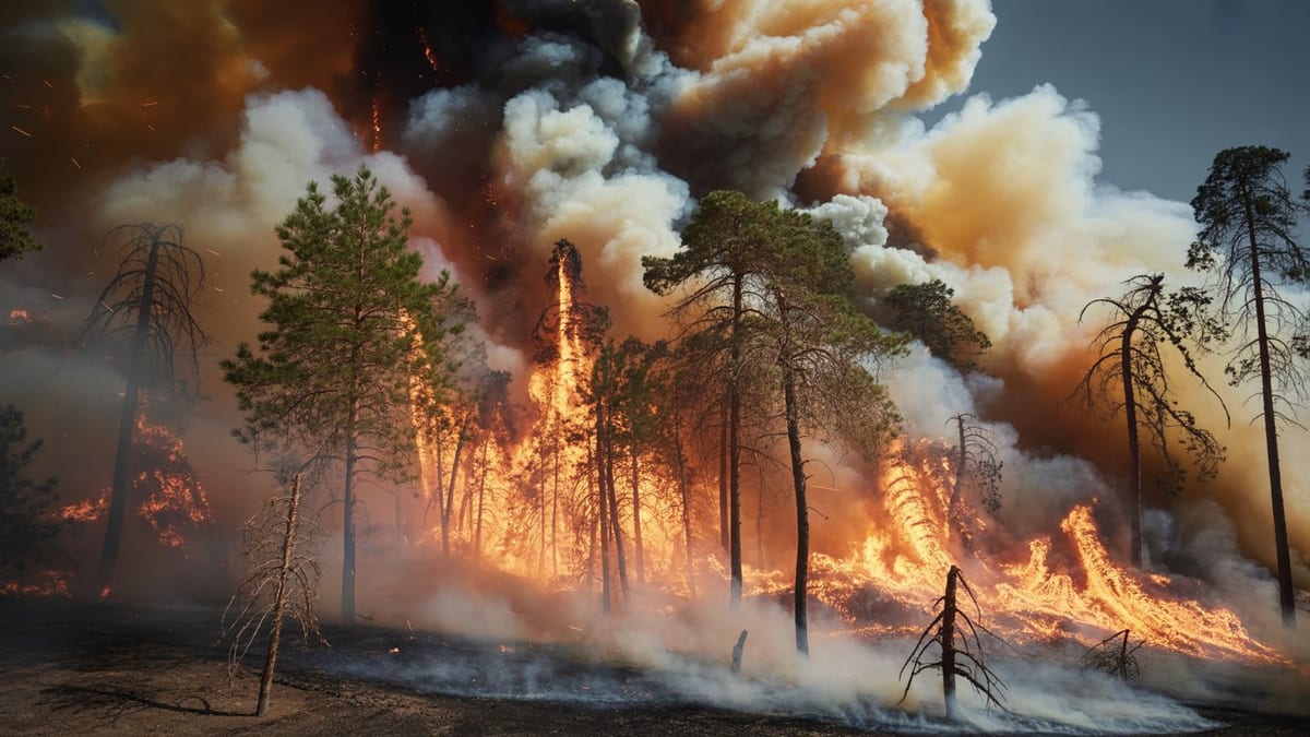
Image by Global Travel Alerts, Advisories, International Travel Alerts
Expanding Fires Reshape a Traditionally Low-Risk State
Recent fire activity at Poplar and Tarkiln Ridge is challenging long-held perceptions of North Carolina as a state largely insulated from the large, landscape-scale wildfires more often associated with the West. Publicly available mapping and incident data indicate that both fires have spread across rugged terrain, in some places advancing through dry leaf litter and dense understory that accumulated after a winter of erratic precipitation. The combination of steep slopes, gusty winds and limited road access has complicated efforts to keep fire lines in place.
These incidents come on the heels of an unusually active fire period for the broader Southeast, where a combination of drought, unseasonably warm temperatures and episodic wind events has driven rapid fire growth from the Appalachian foothills to the coastal plain. Regional climate assessments describe a pattern of longer warm seasons and more variable rainfall, conditions that leave vegetation alternately parched and primed to burn. As the Poplar and Tarkiln Ridge fires expand, North Carolina’s experience is increasingly aligned with this emerging Southeast-wide pattern.
Fire analysts note that the current situation reflects both immediate weather triggers and deeper structural changes in the landscape. Decades of fire exclusion in many North Carolina forests have allowed flammable shrubs and small trees to build up beneath taller canopies. When combined with modern climate extremes, these fuels can carry fire into places where it historically burned less frequently or less intensely, turning what might once have been short-lived flare-ups into more complex wildfires.
Communities at the Forest Edge Face Heightened Threats
The Poplar and Tarkiln Ridge fires are burning in and around areas where forest and community boundaries blur, heightening concern for residents who live along narrow mountain roads or in small subdivisions tucked into coves and ridgelines. According to published coverage of similar recent fires in the southern Appalachians, smoke can reduce visibility on winding highways while embers carried downslope or across drainages can threaten homes that may be several miles from the active flame front. This pattern is familiar to western states but still relatively new for many North Carolina communities.
Local emergency information channels have emphasized the importance of readiness in these so-called wildland urban interface zones, where houses, outbuildings and vehicles sit amid hardwood stands and pine thickets. Guidance in recent years has focused on clearing leaves and debris from roofs and gutters, creating defensible space around structures and understanding evacuation notifications. The growth of the Poplar and Tarkiln Ridge fires is putting that messaging to the test in real time as residents track changing conditions.
Population growth in mountain and foothill counties has added another layer of complexity. As more people seek homes near national forests, state game lands and scenic ridges, the number of properties in potential fire paths increases. Planning documents in western North Carolina already highlight concerns about development on steep slopes and in narrow hollows where escape routes can be limited. The current fires reinforce calls from land-use and wildfire planners for closer coordination between housing decisions and fire-risk mapping.
Ecological Impacts Stretch From High Ridges to Headwater Streams
Beyond immediate threats to homes and infrastructure, the Poplar and Tarkiln Ridge fires are reshaping parts of North Carolina’s forest ecosystems. The affected landscapes include mixed hardwood stands, pockets of pine and rhododendron thickets that, under certain conditions, can burn hot enough to scorch tree canopies. Conservation groups and forest ecologists have long warned that when fires run through heavy fuel loads under dry, windy conditions, they can damage soils, kill mature trees and open the door to erosion on already fragile slopes.
Headwater streams that rise near ridgelines are another concern. Ash and disturbed soil can wash into creeks after heavy rain, affecting water quality and aquatic life downstream. In the southern Appalachians, where tourism and local economies often depend on clear rivers, healthy trout populations and scenic waterfalls, such impacts can linger long after flames are out. Reports from previous large fires in neighboring states describe multi-year efforts to stabilize hillsides, replace damaged culverts and monitor stream health.
Not all ecological effects are negative. Fire has a natural role in many southeastern forests, and low to moderate intensity burns can reduce accumulated fuels, recycle nutrients and create habitat openings for a variety of plants and wildlife. The challenge, specialists emphasize, is that unplanned wildfires like those at Poplar and Tarkiln Ridge are unfolding in landscapes heavily influenced by roads, power lines and homes. That reality narrows the margin for allowing beneficial fire to play out while still protecting people and infrastructure.
Part of a Broader U.S. Wildfire Crisis
The expansion of the Poplar and Tarkiln Ridge fires is occurring against the backdrop of a nationwide increase in destructive wildfires. National summaries from recent years show that the United States has recorded more frequent large incidents across multiple regions, with the Southeast joining the West and parts of the Plains as recurring hotspots. In some seasons, southern and Appalachian states have accounted for a significant share of national fire activity, particularly during dry springs when vegetation is exposed and winds are strong.
Climate research synthesized by federal agencies and academic institutions points to a convergence of factors driving this trend, including higher average temperatures, stretches of intense drought punctuated by heavy rain and storms that topple trees and add to future fuel loads. In North Carolina, this pattern has been visible in recent years through a combination of major hurricanes, severe storms and, increasingly, periods of elevated fire danger in both coastal and mountain regions.
The Poplar and Tarkiln Ridge fires illustrate how this national crisis now encompasses a wider range of landscapes than the conifer forests and chaparral slopes that dominated wildfire imagery a decade ago. Oak-hickory ridges, mixed-use valleys and second-growth forests in the southern Appalachians are now part of the same story, where fire seasons are longer, windows for safe prescribed burning are narrower and the cost of firefighting and recovery continues to rise.
State and Regional Strategies Evolve as Risks Grow
North Carolina’s response to the Poplar and Tarkiln Ridge fires is unfolding within a broader shift in how the state and region approach wildfire risk. Publicly available planning documents show an increased emphasis on community wildfire protection plans, cross-jurisdictional training and investments in specialized equipment suited to the steep, heavily wooded terrain of the mountains. The goal is to move from reactive, incident-by-incident firefighting toward a more integrated strategy that addresses fuels, development patterns and public awareness.
Prescribed burning has become a central part of that strategy across the South, including in North Carolina’s national forests and state-managed lands. When weather and smoke-dispersion conditions allow, carefully planned burns can reduce the very fuels that now power the Poplar and Tarkiln Ridge fires. However, narrow windows of suitable conditions, smoke concerns near populated areas and the need for trained crews all limit how much prescribed fire can realistically be applied each year.
At the community level, recent fire seasons have prompted renewed attention to building codes, road access and neighborhood-level risk reduction. Homeowners near forest edges are being encouraged to think beyond immediate property lines, coordinating with neighbors to remove shared hazards such as overgrown access roads and continuous belts of flammable vegetation. As the current fires evolve, these collective actions may play a decisive role in how well communities weather the advancing flames and what rebuilding and recovery will look like once the smoke clears.