
More news on this day
Morocco is facing a spell of severe winter weather as heavy rain, mountain snow, and powerful winds sweep across wide areas of the country, prompting red and orange alerts from the national meteorological service and fresh safety warnings for travelers.
From the Rif and northern Atlantic coast to the Middle and High Atlas, authorities are bracing for possible flash floods, road closures, and disruption to transport from Monday through Wednesday, with the most intense conditions expected on Wednesday, February 4, 2026.
More News
- TSA Rolls Out $45 ConfirmID Fee for Travelers Without REAL ID at Security
- Flying Blue Launches February 25% Promo Rewards on Transatlantic and Regional Routes
- United Fast-Tracks Starlink Wi‑Fi Across Fleet, Free for MileagePlus Members
Latest Alerts: Where the Weather Is Hitting Hardest
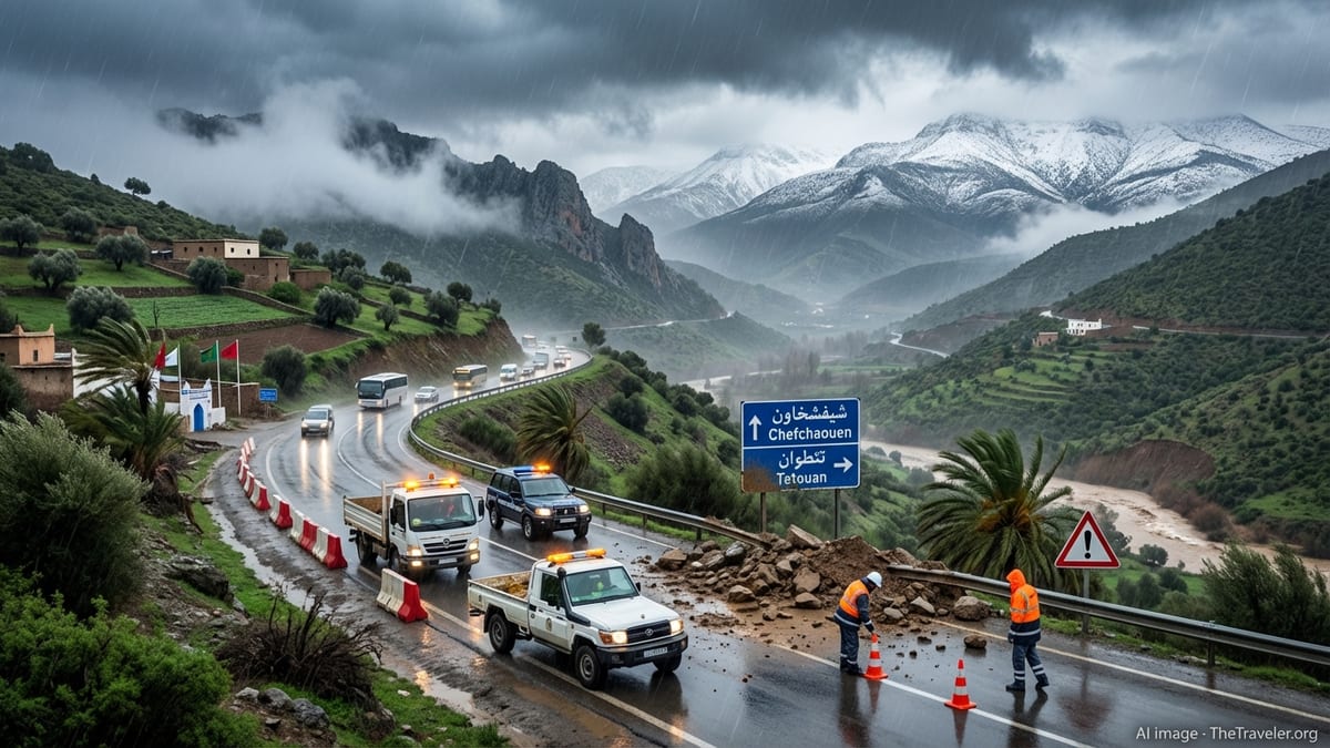
The General Directorate of Meteorology has placed several northern provinces under a red-level alert, the highest in Morocco’s warning system, for very heavy rainfall. Between 100 and 150 millimeters of rain are forecast from midnight until 11 p.m. on Wednesday in Chefchaouen, M’diq Fnideq, Tetouan, Tanger Assilah, Ouezzane, Larache, and Fahs Anjra. These totals, falling in less than 24 hours on already saturated ground, significantly increase the risk of rapid flooding in valleys and low-lying urban areas.
Surrounding provinces are under orange-level alerts for substantial rain totals, generally between 40 and 100 millimeters, including Taounate and Al Hoceima in the north and parts of Kenitra and Taza further south and inland. In earlier bulletins, authorities also highlighted the potential for locally thundery downpours, with embedded storms capable of producing sudden bursts of heavier rain and small hail.
At higher elevations, a separate series of alerts cover heavy snowfall, with accumulations of 40 to 60 centimeters expected above around 1,500 meters in provinces such as Al Hoceima, Sefrou, Boulemane, Taza, Guercif, Ifrane, Midelt, Beni Mellal, Khenifra, and Tinghir. Additional snowfall of 10 to 40 centimeters is anticipated in Al Haouz, Azilal, Ouarzazate, and Chefchaouen, extending hazardous conditions along many popular mountain routes.
Strong wind gusts, sometimes exceeding 75 to 90 kilometers per hour, are forecast for a broad swathe of northern and eastern Morocco. Provinces including Tangier Assilah, Al Hoceima, Larache, Chefchaouen, Tetouan, M’diq Fnideq, Oujda Angad, Figuig, Jerada, Taourirt, Berkane, Driouch, Guercif, Ifrane, Boulemane, and several central regions are on alert for potentially damaging gusts and blowing dust, particularly on exposed plateaus and passes.
Timing the Worst of the Storm: Monday to Wednesday Outlook
The current episode is unfolding in several phases, stretching from Monday, February 2, through Wednesday, February 4, 2026. On Monday, strong winds and the first bands of heavy rain swept into northern and northeastern provinces, with gusts up to 90 kilometers per hour reported in coastal and inland areas from Tangier to the Oriental region. During the same period, snow began accumulating across parts of the Middle and High Atlas as colder air advanced southward.
Forecasts indicate that the period from late Monday into Tuesday midday will bring sustained heavy rain to the northern coastal strip and adjacent inland provinces. Cities and towns in Tangier Assilah, Larache, Tetouan, M’diq Fnideq, Ouezzane, Chefchaouen, Fahs Anjra, Taounate, and Al Hoceima can expect 50 to 80 millimeters of rain during this window, with additional showers continuing into Tuesday night. These conditions will be accompanied by thunderstorms in places, potentially intensifying downpours for short intervals.
The most severe conditions are expected on Wednesday, when the red-level alert for very heavy rainfall comes into force. From midnight to late evening, a slow-moving disturbance is forecast to linger over the Rif region and parts of the northern Atlantic coast, focusing the heaviest precipitation over Chefchaouen, Tetouan, M’diq Fnideq, Tangier Assilah, Ouezzane, Larache, and Fahs Anjra. Higher terrain in these provinces could see even greater localized totals due to orographic effects, where moist air is forced up mountain slopes and condenses into heavy rain.
Throughout the episode, snow will continue to accumulate over elevations above approximately 1,500 meters, with the heaviest falls occurring from Monday afternoon to Wednesday morning. In parallel, a pool of cold air will drop daytime temperatures sharply in interior highlands, with early forecasts pointing to minimum temperatures between minus 6 and 0 degrees Celsius in some mountain areas on Tuesday and Wednesday, further complicating travel.
Impact on Roads, Transport, and Travel Plans
The Ministry of Equipment and Water and Morocco’s road safety authorities have issued strong messages urging drivers to exercise heightened caution and, where possible, postpone non-essential road journeys during the peak of the storm. With heavy rain, sleet, and snow affecting major axes connecting the north to central and eastern regions, intermittent closures or slowdowns are expected on mountain roads, especially on passes in the Rif, Middle Atlas, and High Atlas ranges.
Officials warn that traffic disruptions are likely on segments crossing the provinces most exposed to heavy rainfall, including Chefchaouen, M’diq Fnideq, Tetouan, Tangier Assilah, Ouezzane, Larache, Fahs Anjra, Taounate, and Al Hoceima. Localized flooding, mudslides, and rockfalls are all possible, particularly along steep slopes and in narrow gorges. Drivers may encounter temporary diversions, reduced visibility, standing water, or sections where only one lane remains passable.
In snow-affected areas such as Ifrane, Midelt, Beni Mellal, Azilal, Khenifra, Tinghir, Al Haouz, Ouarzazate, Al Hoceima, and Chefchaouen, authorities are preparing snowplows and gritting operations to maintain priority roads as long as conditions allow. Nonetheless, closures of secondary and tertiary roads are possible as snow accumulates and temperatures fall below freezing, making surfaces slick and increasing the risk of skidding.
For international travelers, the strongest impact is likely to be felt in overland transport rather than in major airports, though flight operations can also be disrupted by strong winds and low cloud. Coach routes between Tangier, Tetouan, Chefchaouen, Fez, Rabat, and Casablanca may see delays or cancellations, particularly for overnight services that traverse mountain corridors. Ferry links across the Strait of Gibraltar have already been affected by recent episodes of rough seas and strong winds, and further schedule adjustments are possible as the storm progresses.
What This Means for Tourists in Northern Cities and Mountain Regions
For visitors currently in Morocco, the severe weather comes at a time when winter tourism is active in both coastal cities and mountain resorts. Travelers based in Tangier, Tetouan, Chefchaouen, or Al Hoceima should anticipate periods of very heavy rain, gusty winds, and localized flooding in urban districts with poor drainage. Outdoor sightseeing, walking tours in medinas, and coastal excursions may need to be rescheduled, and some local attractions could reduce hours or close temporarily depending on conditions.
In popular mountain destinations such as Ifrane, Azilal, Ouarzazate, Midelt, and High Atlas villages that serve as bases for trekking, the mix of heavy snow and strong winds significantly elevates the risk of avalanches, falling branches, and road blockages. Hikes and off-road excursions planned for early this week should be reconsidered, especially those involving unmarked trails, remote passes, or high ridgelines above 2,000 meters. Guides and lodge owners are closely watching the forecasts and may proactively cancel or adjust itineraries.
Tourists driving rental cars are strongly advised to check local advisories before setting off, particularly if their route crosses mountain areas or flood-prone valleys. Many rural roads are not designed for rapid runoff and can quickly become impassable when water levels rise. Travelers without winter driving experience, especially in snow and ice, should avoid mountain roads altogether until conditions stabilize and official agencies confirm that major routes are safe.
Urban travelers in Rabat, Casablanca, and other central coastal cities are not at the core of the highest alerts, but intervals of moderate to heavy rain, brisk winds, and possible water pooling on roads are likely. Visitors should factor slower traffic into airport transfers, train connections, and intercity bus journeys. It is prudent to allow additional time for all movements and to maintain flexibility in daily plans.
Safety Advice and Practical Steps for Visitors
Authorities and road safety agencies have reiterated a series of basic precautions for residents and visitors alike. Road users are being urged to slow down, keep greater distances between vehicles, avoid sudden braking or overtaking, and switch on dipped headlights in poor visibility. Drivers are also asked to check tire tread, brakes, windshield wipers, and lights before traveling, as mechanical issues can quickly become critical in heavy rain or snow.
Travelers staying in mountain areas should pay particular attention to local advice on avalanche and landslide risks. Walking or driving close to steep, saturated slopes, riverbanks, or dry wadis that can suddenly fill is strongly discouraged. Many rural communities rely on roads that snake through narrow valleys and under rocky cliffs, where debris flows are more likely after intense rainfall.
In coastal and port areas, high winds and heavy seas can make waterfront promenades, breakwaters, and harbor walls hazardous. Visitors are advised to stay away from crashing waves, which can unexpectedly surge over barriers and sweep people into the water. Boat trips, small-vessel outings, and certain water sports may be suspended until the weather system passes.
From a broader safety perspective, travelers should ensure that mobile phones are fully charged, carry basic supplies such as water, warm clothing, and snacks when heading out on any longer journey, and keep hotel or local contact details accessible. It is also wise to have a backup plan for accommodation in case planned routes become impassable or transport options are curtailed.
Climate Context: Powerful Storms After Years of Drought
The current episode forms part of a more turbulent pattern of winter weather observed in Morocco over recent seasons. After years of prolonged drought that strained reservoirs, agriculture, and water supplies, the country has seen a succession of powerful storms, including systems such as Storm Francis earlier this year, bringing intense rainfall, strong winds, and renewed concerns about flooding and infrastructure resilience.
Climatologists have noted that while increased rainfall offers some relief to parched basins, the manner in which it arrives is crucial. Long dry spells punctuated by short bursts of very heavy rain can magnify runoff, erode soils, and overwhelm drainage systems, particularly in fast-growing urban areas and steep rural catchments. When combined with snowmelt in the mountains, these downpours can feed sudden surges in rivers and wadis downstream.
In northern Morocco, the Rif mountains are especially susceptible to landslides and flash flooding due to their rugged terrain and geology. Repeated episodes of intense rainfall, such as those currently affecting Chefchaouen and neighboring provinces, place additional stress on hillside communities, road networks, and terraced agricultural plots. Authorities are increasingly focused on both short-term alert systems and longer-term adaptation measures, including slope stabilization and improved drainage.
For the tourism sector, the growing volatility of winter weather underscores the need for flexible planning, better communication with visitors, and robust contingency arrangements. Hotels, tour operators, and transport providers are refining protocols for weather-related cancellations, route changes, and guest support, recognizing that such episodes may become more frequent or intense in coming years.
How Travelers Can Monitor Evolving Conditions
Given that conditions can change rapidly within a single day during severe weather, travelers are encouraged to monitor multiple sources of information. Official bulletins from the General Directorate of Meteorology provide the most authoritative overview of red and orange alerts, indicating both the provinces concerned and the time windows for expected impacts. Updates from the Ministry of Equipment and Water and national road safety agencies offer more granular detail on the status of highways and secondary roads.
Visitors staying in hotels or guesthouses can also rely on local hosts and guides, who typically keep a close eye on regional forecasts and road conditions. Many accommodation providers in mountain and rural areas receive direct notifications about closures or difficult stretches of road on key routes used by tourists, such as those linking Marrakech to the High Atlas passes or connecting northern cities with inland plateaus.
For those traveling by train or coach, operators often post service notices and schedule changes at stations and depots, as well as through their customer service channels. In periods of heavy rain and strong winds, services may be delayed rather than canceled outright, but connections can be missed if travelers do not allow sufficient margin in their itineraries.
Above all, visitors are advised to remain flexible with any plans involving long-distance travel, high mountain areas, or outdoor activities. Booking conditions that allow changes or refunds, especially during the core winter months, can help reduce the financial impact of weather-related disruption. Travelers should think of itineraries as adaptable frameworks rather than rigid timetables when red and orange weather alerts are in force.
FAQ
Q1: Which Moroccan regions are most affected by the current severe weather?
The heaviest impacts are forecast for northern provinces such as Chefchaouen, M’diq Fnideq, Tetouan, Tangier Assilah, Ouezzane, Larache, Fahs Anjra, Taounate, and Al Hoceima, where very heavy rain, strong winds, and, in some higher areas, snow are expected. Mountainous provinces in the Middle and High Atlas, including Ifrane, Midelt, Beni Mellal, Azilal, Khenifra, Tinghir, Al Haouz, and Ouarzazate, are also affected by significant snowfall.
Q2: How long will the severe weather last?
The current episode is expected to unfold from Monday, February 2, to Wednesday, February 4, 2026, with varying intensity. The most critical period for heavy rain in the north is forecast from late Tuesday night through Wednesday evening, while snowfall in the mountains may continue to accumulate from Monday afternoon into Wednesday morning.
Q3: Is it safe to travel by road during this period?
Travel by road is possible but may be hazardous in areas under red and orange alerts. Authorities recommend avoiding non-essential journeys, especially at night and in mountainous or flood-prone regions. If travel is unavoidable, drivers should proceed slowly, keep extra distance from other vehicles, avoid flooded sections of road, and check official advisories for closures or restrictions before departure.
Q4: Are flights and trains likely to be disrupted?
Major airports and intercity rail lines are generally more resilient than smaller roads, but they can still experience delays during episodes of heavy rain and strong winds. While widespread cancellations are not guaranteed, travelers should anticipate possible schedule changes, allow extra time for transfers, and monitor updates from airlines and rail operators on the day of travel.
Q5: What should tourists staying in mountain areas do?
Tourists in mountain regions should consult their hosts or guides, follow local advice closely, and consider postponing hikes, treks, and long drives over high passes until the weather improves. Staying within or near main settlements, avoiding remote trails and unpaved tracks, and ensuring access to warm clothing, food, and communication devices are all recommended.
Q6: How can I stay informed about the latest weather alerts?
The most reliable updates come from Morocco’s General Directorate of Meteorology, supported by statements from the Ministry of Equipment and Water and national road safety agencies. Local news outlets, hotels, guesthouses, and licensed guides also play an important role in relaying the latest information, particularly in remote or mountainous areas.
Q7: What are the main risks for urban visitors in cities like Tangier or Tetouan?
Urban visitors face risks linked primarily to heavy rainfall and strong winds, including localized flooding in low-lying districts, slippery pavements, falling branches or loose objects in gusty conditions, and traffic congestion. It is advisable to avoid walking or driving through deep water, to steer clear of large trees and poorly secured structures during strong gusts, and to allow extra time for getting around the city.
Q8: Will popular tourist activities such as hiking and desert tours be affected?
Yes, many outdoor activities may be postponed or canceled during the alert period. Hiking in the Rif, Middle Atlas, and High Atlas is particularly risky under heavy rain or snow, while desert excursions may face access issues if approach roads are flooded or damaged. Reputable tour operators will typically adjust schedules or offer alternatives in light of safety considerations.
Q9: What precautions should I take if I must drive during the storm?
If you must drive, ensure your vehicle is in good mechanical condition, check the state of tires, brakes, lights, and wipers, and keep your fuel tank well topped up. Reduce speed, increase following distance, use headlights in poor visibility, avoid sudden maneuvers, and never attempt to cross fast-flowing or deep water. Carry warm clothing, water, and basic supplies in case of delays.
Q10: Should I change my travel plans to Morocco because of this weather?
Whether to change plans depends on your itinerary and flexibility. Those planning to focus on high mountain trekking or extensive road trips through the north and interior over the coming days may wish to adjust dates or routes. Travelers with more urban-focused stays can often continue with their trips while building in flexibility for rainy days and potential transport delays. In all cases, monitoring official updates and maintaining adaptable plans is essential.