
Saudi Arabia sprawls across most of the Arabian Peninsula, a country of holy cities, volcanic peaks, coral seas and some of the largest sand deserts on Earth. For travelers, understanding how its regions fit together is the key to planning a rewarding journey, whether you are drawn by Red Sea reefs, modern skylines, mountain villages or the empty silence of the Rub al Khali.
The Big Picture: How Saudi Arabia Is Geographically Divided
At its simplest, Saudi Arabia is often understood through three broad geographic bands: the Red Sea coast in the west, the central plateau of Najd, and the Gulf coast and deserts in the east. Layered on top of this are 13 administrative provinces, from Riyadh and Makkah to the sparsely populated Northern Borders and Najran, each with its own capital city and local character.
The western Hejaz region, which historically includes today’s Makkah, Madinah, Tabuk and Al Baha provinces, forms a spine of mountains and escarpments that drop to a hot coastal plain called the Tihamah along the Red Sea. To the east of these mountains lies the vast Najd plateau, a rocky interior studded with oases and the fast-growing capital region of Riyadh. Farther east, the land descends toward the Gulf, where the Eastern Province combines oil fields, modern coastal cities and swathes of desert.
In the south, the terrain changes again as the Asir and Jazan regions meet the Yemeni border. Here the Sarawat Mountains reach some of the country’s highest elevations, creating a cooler and greener climate than most visitors expect from Arabia. Beyond the highlands, the sands open into the Rub al Khali, or Empty Quarter, a gigantic sand sea that covers much of the kingdom’s southeast and spills into neighboring Oman, Yemen and the United Arab Emirates.
For travelers, these natural regions matter as much as the official map. They shape the seasons, the experiences on offer and how comfortably you can move between urban exploration, heritage sites, wilderness and the sea. A week in Saudi Arabia might mean combining the spiritual gravity of Makkah and Madinah, the cultural pull of Jeddah and AlUla, and the wild vastness of deserts that begin only hours outside the cities.
Hejaz: Holy Cities, Red Sea Gateways and Volcanic Highlands
The Hejaz is the historic western corridor of Arabia, stretching along the Red Sea from the Jordanian border down toward Yemen. It is home to Islam’s two holiest cities, Makkah and Madinah, as well as the modern commercial port of Jeddah and the emerging heritage destination of AlUla. Together they form the most visited region of the kingdom, welcoming millions of pilgrims and, increasingly, leisure travelers each year.
Makkah and Madinah are both set slightly inland from the Red Sea, linked to Jeddah and the wider world by modern highways and high-speed rail. While religious tourism remains tightly regulated, the infrastructure built for pilgrims means improved airports, hotels and transport that benefit secular visitors as well. Jeddah, often described as the country’s most cosmopolitan city, sits directly on the Red Sea and offers a different side of Hejazi life, from its historic coral-stone district of Al Balad to a waterfront lined with cafes and public art.
North along the Hejaz escarpment lies AlUla, where sandstone cliffs and rock formations shelter ancient tombs and inscriptions. The UNESCO-listed site of Hegra, sometimes called Mada in Salih, showcases monumental facades carved by the Nabataeans, the same civilization that built Petra across the border in Jordan. Around these ruins, Saudi authorities have been developing low-density, upscale resorts and outdoor experiences pitched toward international visitors attracted by archaeology and desert scenery.
Climatically, the Hejaz is varied. The coastal Tihamah plain is hot and humid for much of the year, while the nearby escarpment and plateaus bring slightly cooler air and, in some pockets, winter rainfall. That variation allows travelers to pair days by the sea in Jeddah or Yanbu with cooler evenings in mountain towns such as Taif or Al Baha, especially from late autumn to early spring when conditions are most pleasant.
Najd and the Central Plateau: Riyadh and the Heart of the Interior
East of the Red Sea mountains the land rises into the Najd, a broad plateau that historically supported tribal confederations, caravan routes and oasis settlements. Today this interior region is dominated by Riyadh Province and the capital city itself, which has grown into one of the largest metropolises in the Arab world. The landscape surrounding Riyadh is a mix of escarpments, dry riverbeds called wadis and gravel plains that slope gently toward the Gulf.
Riyadh offers the densest concentration of urban experiences in the kingdom, with modern museums, high-rise districts and restored historic quarters like Diriyah, the ancestral home of the Saudi ruling family. Only a short drive from the city center, travelers can reach viewpoints over the Jabal Tuwayq escarpment, sometimes called the Edge of the World, where cliffs drop dramatically to the deserts below. These contrasts, between steel-and-glass urbanity and stark rocky horizons, define much of the Najdi experience.
Beyond Riyadh, other central regions such as Qassim and Hail are dotted with mid-sized cities like Buraidah, Unaizah and Ha’il, each built around oases fed by underground aquifers. These areas have deep agricultural traditions, producing dates and other crops that flourish in pockets of irrigated land surrounded by arid plains. For travelers, they offer a quieter window into everyday Saudi life, with markets, mud-brick architecture and seasonal festivals tied to harvests and camel breeding.
The climate of Najd is sharply continental, with very hot summers and cooler winters that can occasionally bring chilly nights. Rainfall is limited and irregular, falling mainly in short bursts that run through wadis and quickly evaporate. Visiting from roughly November to March makes city walking and desert excursions more comfortable, while the height of summer is better suited to short, well-planned outings bracketed by time in air-conditioned interiors.
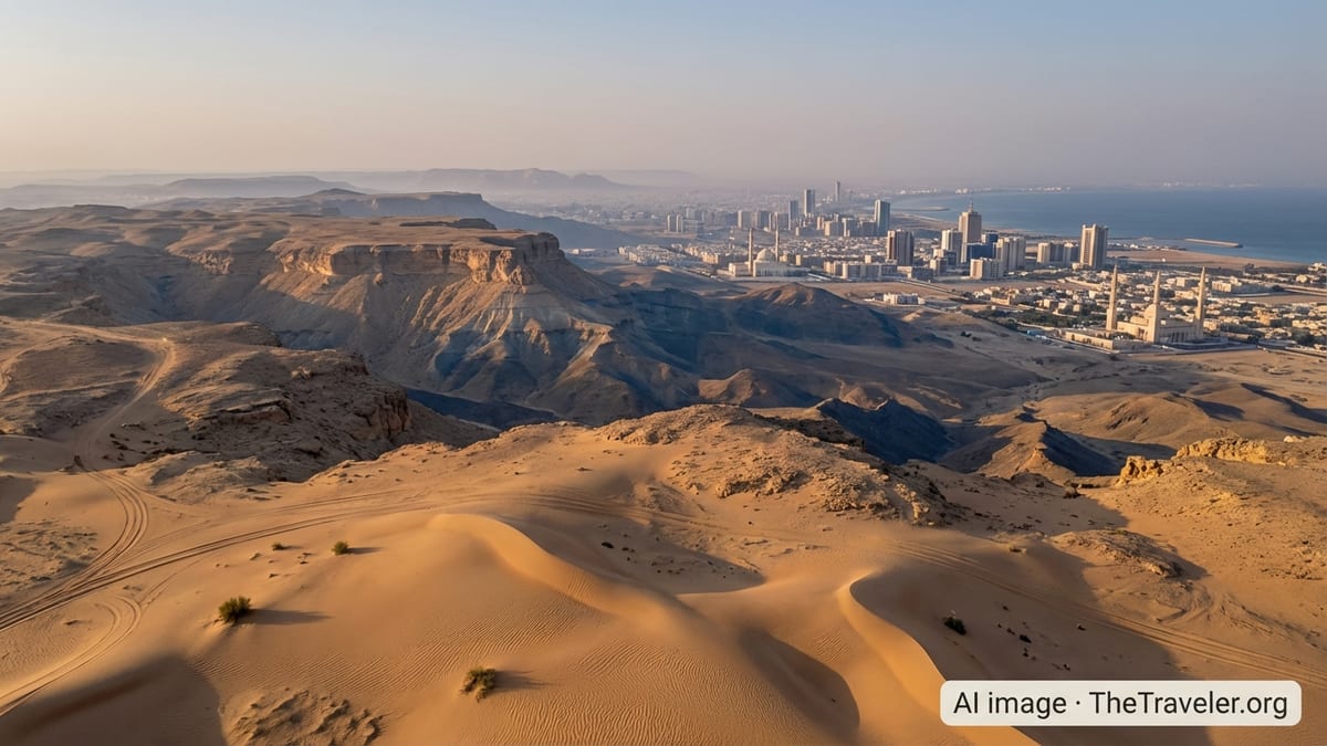
The Eastern Province and Gulf Coast: Oil Cities, Oases and Sand Seas
Saudi Arabia’s entire coastline along the Arabian Gulf lies within the Eastern Province, the country’s largest region by area. Here, modern industrial cities such as Dammam, Dhahran, Khobar and Jubail line the shore, linked by highways and causeways to neighboring Bahrain, Qatar and the United Arab Emirates. Inland, the vast Al Ahsa Oasis and other settlements form green interruptions in a landscape dominated by sand and gravel deserts.
The Eastern Province is central to the country’s energy economy, but it is increasingly important in tourism too. Beachfront corniches in Dammam and Khobar, family-oriented coastal resorts and easy access to nearby Gulf states make the area attractive to regional travelers. Offshore, the Gulf’s relatively shallow waters and small islands appeal to divers and anglers, although visibility and marine life are different from the coral-rich Red Sea.
Inland from the coast, three major deserts shape the region. To the north, the Nafud extends into the Northern Borders, while the narrow Dahna corridor of sand runs south along the edge of the Jabal Tuwayq escarpment. Farther still, the Rub al Khali spreads across the southeastern third of the peninsula. Its reddish-orange dunes can reach heights similar to city skyscrapers and create an environment of extreme aridity, with blistering summer temperatures and minimal rainfall.
Travel into these interior deserts is increasingly possible through guided expeditions, particularly around the fringes of the Rub al Khali and in areas like Hafr al Batin and Al Ahsa. Experiences focus on dune driving, stargazing and encounters with Bedouin cultural traditions. Given the conditions, journeys here require careful planning, experienced operators and a clear understanding that distances are long and services sparse outside established towns.
Southern Highlands and Asir: Green Mountains Above the Desert
Contrary to many expectations of Arabia, Saudi Arabia’s southwestern corner is often cool, misty and green. The Asir and Jazan regions climb into the Sarawat Mountains, where elevations can surpass 2,000 meters, catching moisture from Red Sea air masses. Terraced fields, juniper forests and small mountain villages cling to slopes that drop steeply toward the coastal plain below.
The city of Abha, capital of Asir, has become a domestic tourism hub thanks to its milder climate. Summer temperatures here can be several degrees lower than in the lowlands, and winter evenings can feel brisk. Cable cars, mountain parks and viewpoints over dramatic escarpments draw families during school holidays, while nearby villages showcase traditional stone and mud architecture painted in bright geometric patterns.
Farther south, Jazan Province pairs offshore islands and mangrove-fringed coasts with foothill farms that cultivate crops such as coffee in suitable microclimates. The highlands near the Yemeni border are culturally close to northern Yemen, with shared traditions in dress, architecture and music. While access to some areas can be restricted or sensitive due to security considerations, the broader region is gradually opening to more structured tourism.
For travelers, the southern highlands offer a different palette of experiences than the rest of the country: hiking on marked trails, cooler-weather picnics and opportunities to observe migratory birds that funnel along the Red Sea corridor. Visiting outside the peak of the rainy season reduces the risk of low cloud and fog obscuring the views, though many visitors find the passing mists and sudden clearings part of the region’s charm.
Red Sea Coastline and Island Projects: From Jeddah to the New Resorts
Saudi Arabia’s Red Sea coast stretches for more than a thousand kilometers, with long runs of undeveloped shoreline, coral reefs and barrier islands. The established gateway is Jeddah, with its international airport and cruise-ready port, but new focal points are emerging as the government invests heavily in coastal tourism under its Vision 2030 agenda.
One of the most prominent initiatives is the Red Sea destination being developed between Umluj and Al Wajh. This area, long known locally for its clear waters and offshore islands, is being transformed into a series of low-density, high-end resorts and nature-based experiences. New air links, including a purpose-built airport designed for international arrivals, aim to shorten travel times from Europe, Asia and other parts of the Middle East.
Farther north, on the Gulf of Aqaba, the NEOM region has been promoted as a laboratory for new approaches to urbanism and tourism. While some elements, such as the Sindalah island resort, have already begun hosting guests, other more ambitious components are being reassessed and phased over a longer horizon in light of costs and practical constraints. For travelers, the practical takeaway is that offerings here are evolving; it is worth checking which components are actually operating before planning a visit.
Alongside these headline projects, Saudi authorities have introduced new regulations for beaches and coastal operators, including standardized safety, environmental and service requirements. A digital guide for visitors and investors is being rolled out to help catalog public and private beaches and highlight facilities, which should gradually make it easier for independent travelers to find well-managed stretches of coast suitable for families, water sports or quiet escapes.
Urban Saudi Arabia: Key Cities and How They Relate to the Landscape
Understanding Saudi Arabia’s cities means understanding the landforms beneath and around them. Riyadh sits on the Najd plateau close to the Jabal Tuwayq escarpment, a position that historically gave it access to caravan routes and oases. Today, its ring roads and metro lines trace paths across a dry basin that only occasionally sees surface water flow after seasonal storms.
On the Red Sea, Jeddah and Yanbu have flourished as ports where goods and people from Africa, Asia and Europe connect with the interior. Their districts extend parallel to the shoreline, with seaside corniches acting as communal living rooms during the cooler evenings. Makkah and Madinah, by contrast, are cradled among hills slightly inland, their religious significance ensuring a constant rhythm of arrivals and departures regardless of the season.
In the east, the Dammam metropolitan area, which also includes Dhahran and Khobar, faces the Arabian Gulf and is knitted together with industrial zones, residential districts and seaside promenades. Close by, the extensive Al Ahsa Oasis reminds visitors that even in a hyper-arid environment, groundwater and irrigation can sustain large communities and patchworks of date palms.
Smaller regional centers, from Abha in the mountains to Tabuk in the northern Hejaz, Hail in the interior and Jazan on the southern coast, provide access to the country’s most distinctive landscapes. These cities often serve as staging points for trips into deserts, highlands or island archipelagos. For travelers crafting an itinerary, thinking in terms of “gateway cities” and the natural regions they unlock can be more helpful than focusing purely on provincial boundaries.
The Takeaway
Saudi Arabia is not a single flat expanse of sand but a mosaic of regions shaped by mountains, coasts and deserts, each with its own climate, culture and travel possibilities. The Hejaz offers sacred cities and Red Sea corridors; Najd brings modern skylines and stark interiors; the Eastern Province links oil hubs, oases and the edge of the Empty Quarter; the southern highlands reveal a cooler, greener Arabia; and the Red Sea and Gulf coasts frame it all with beaches and reefs.
For visitors, the most rewarding journeys pay attention to these contrasts. A thoughtfully planned route might start in coastal Jeddah and the holy cities, swing north to the sandstone canyons of AlUla, cross the plateau to Riyadh’s urban energy, dip into the Eastern Province to glimpse Gulf life and desert horizons, then finish amid the cool air of Asir’s escarpments. As large-scale tourism projects continue to unfold alongside longstanding cultural and religious travel, the geography of Saudi Arabia will shape not only where visitors go, but how they experience the kingdom’s rapid transformation.
FAQ
Q1. How many main regions should travelers think about when planning a trip to Saudi Arabia?
Most travelers find it helpful to think in terms of five broad regions: the western Hejaz and Red Sea corridor, the central Najd plateau around Riyadh, the Eastern Province and Gulf coast, the southern highlands of Asir and Jazan, and the far deserts including the Nafud and Rub al Khali.
Q2. What is the difference between the Hejaz and Najd?
The Hejaz is the mountainous and coastal western belt that includes Makkah, Madinah and Jeddah, while Najd is the elevated central plateau dominated by Riyadh and a scattering of oasis towns. The Hejaz faces the Red Sea and has a long history as a pilgrimage and trade route, whereas Najd has traditionally been more inward-looking and pastoral.
Q3. Which Saudi desert is known as the Empty Quarter?
The Rub al Khali, or Empty Quarter, is the huge sand desert occupying much of southeastern Saudi Arabia and spilling into neighboring countries. It is one of the largest continuous sand seas on Earth, characterized by towering dunes, extreme heat and very sparse permanent settlement.
Q4. Are Saudi Arabia’s coastal areas all the same?
No, the Red Sea and Arabian Gulf coasts differ noticeably. The Red Sea shoreline is generally deeper and richer in coral reefs and offshore islands, especially between Jeddah and the northern resort projects, while the Gulf coast around Dammam and Khobar offers shallower waters, island-dotted bays and easier overland access to nearby Gulf states.
Q5. When is the best time of year to visit Saudi Arabia’s deserts?
The most comfortable period for desert travel is usually from late autumn through early spring, roughly November to March, when daytime temperatures are milder and nights, while sometimes chilly, are manageable. Summer conditions in the interior can be extremely hot and require careful planning and short excursions.
Q6. Which cities are best as gateways to Saudi Arabia’s mountain regions?
Abha in Asir Province is the main gateway to the southwestern highlands, while Taif and Al Baha provide access to cooler upland areas farther north along the Hejaz escarpment. These cities have airports, road links and growing tourism infrastructure geared toward visitors seeking mountain scenery and milder weather.
Q7. How are Saudi Arabia’s megaprojects changing its coastal regions?
New developments along the Red Sea and Gulf of Aqaba are adding airports, resorts and marinas in previously remote locations. While some projects are being phased or scaled to match economic realities, early components such as select island resorts and beach destinations are already opening, gradually diversifying the coastal tourism offer beyond established cities like Jeddah.
Q8. Is it possible to combine religious, cultural and nature experiences in one itinerary?
Yes, many travelers now combine pilgrim or heritage visits to Makkah, Madinah and AlUla with time in Jeddah or Riyadh, then add desert or mountain excursions. Modern roads, domestic flights and organized tours make it increasingly practical to move between spiritual sites, historic districts and natural landscapes within a single trip.
Q9. Are there greener or cooler areas in Saudi Arabia suitable for summer travel?
The southwestern highlands around Abha and parts of Jazan and Al Baha tend to be cooler and greener than the lowlands, making them popular domestic summer retreats. Even there, daytime temperatures can still be warm, but evenings are usually more comfortable than in the interior deserts or coastal plains at the same time of year.
Q10. How should travelers think about distances and transport between Saudi regions?
Saudi Arabia is large, and distances between key cities can be significant. Highways are generally modern, and domestic flights link major centers, but travelers should factor in long driving times between regions, especially when crossing from the Red Sea side to the Najd interior or the Eastern Province, and plan overnight stays in gateway cities along the way.