
Southern England is braced for another spell of disruptive winter weather this week, as the Met Office issues fresh yellow warnings for heavy rain and snow that threaten to snarl up road, rail and air travel across the region.
New Weather Warnings Target South and Midlands
Forecasters say a fresh area of low pressure sliding in from the Atlantic on Wednesday will collide with cold air already entrenched over much of the UK, setting up a volatile mix of heavy rain, sleet and snow. The Met Office has issued yellow weather warnings for rain across southern England, from Kent to Cornwall, alongside separate snow warnings for parts of Wales and central England including Birmingham and Worcester on Wednesday into Thursday.
The rain warning for the south is currently in force from Wednesday morning into early Thursday, with the heaviest downpours expected through Wednesday afternoon and overnight. In higher parts of the Midlands, mid and southeast Wales and upland areas such as Dartmoor and the Chilterns, forecasters say 2 to 5 centimetres of snow is likely, with 10 centimetres or more possible on the highest routes.
With temperatures widely stuck between 3 and 5 degrees Celsius away from the far southwest, conditions will feel raw, and any lying snow on higher routes is likely to compact into ice. Even where snow does not settle at low levels in the south, the combination of intense rainfall, strong easterly winds and already-saturated ground raises the risk of renewed flooding and transport disruption.
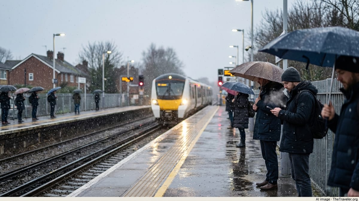
Commuter Corridors in the Firing Line
The latest warnings cover many of southern England’s busiest commuter arteries, including mainline rail routes radiating from London, trunk roads such as the M3, M4 and A303, and sections of the south coast main line through Sussex and Hampshire. With ground conditions saturated after weeks of almost relentless rain, even moderate additional rainfall could be enough to trigger standing water, surface flooding and landslip risks beside transport corridors.
Rail operators are already signalling the possibility of short-notice speed restrictions on exposed stretches of track where heavy rain reduces adhesion or snow begins to settle, particularly on higher sections through the Chilterns and the South West. That in turn could lead to extended journey times, missed connections and a higher risk of short-notice cancellations if rolling stock and crews are displaced.
On the roads, National Highways and local councils are preparing for difficult conditions on higher routes where wet snow may briefly settle, particularly across the Cotswolds, Salisbury Plain and the elevated sections of the A30 and A38 in the South West. Commuters heading into London from satellite towns across Surrey, Berkshire and Kent may also face spray, standing water and localised flooding on key feeder roads into the M25 and other orbital routes.
Flood Risk Elevated After Exceptionally Wet Start to 2026
The warnings come after what meteorologists describe as an exceptionally wet opening to 2026, with repeated Atlantic systems leaving rivers and groundwater levels at or above seasonal records in parts of southern and southwestern England. Hydrologists warn that in some catchments, particularly in the Thames Valley, Wessex and parts of the south coast, the water table is already so high that even relatively small additional rainfall totals could trigger so called groundwater flooding, where water rises up through saturated soil and into streets and properties.
The Environment Agency has maintained dozens of flood alerts and warnings across England in recent days, many of them concentrated in the south and southwest. Officials say that while the coming rainfall totals are not extreme by winter standards, the cumulative effect after weeks of downpours means that drainage networks and smaller rivers have very limited capacity to absorb further water. Low lying communities near chalk streams and in river valleys are among the most exposed.
Urban areas could also see disruption as heavy showers overwhelm highway drains during intense bursts of rainfall. In previous events this winter, commuters in cities such as Exeter, Southampton and parts of outer London have faced road closures and significant delays after short periods of very heavy rain left underpasses and junctions impassable at peak travel times.
Health Officials Issue Cold Weather Alerts
Alongside the Met Office weather warnings, the UK Health Security Agency has activated cold health alerts for most of England, including regions that feed major commuter flows into the capital and other large cities. The alerts, in place from Tuesday evening until at least Friday, warn that the combination of low temperatures, strong winds and wintry precipitation is likely to drive increased demand on health services and poses a heightened risk to elderly people and those with underlying conditions.
Public health officials are urging employers and commuters to factor health risks into their travel decisions this week. Those with respiratory or cardiovascular problems are advised to minimise time spent outdoors in the coldest, wettest conditions and to ensure they carry necessary medication if journeys are unavoidable. There is particular concern for people who may face extended waits for delayed trains or buses on exposed platforms and at unsheltered stops.
Local councils across southern England say they are working to ensure that gritting routes, emergency shelters and support services for rough sleepers are ready for the combined threat of freezing nights and disruptive weather. Commuters are being asked to look out for neighbours who may struggle to get to medical appointments if public transport is affected and to support vulnerable relatives in planning around the worst of the conditions.
How Rail Travellers Can Prepare for Disruption
Rail passengers across the south of England are being advised to treat Wednesday evening and Thursday morning as high risk periods for disruption, particularly on routes crossing higher ground or running through known flood prone areas. Operators typically impose precautionary speed restrictions when heavy rain reduces visibility or when there is a threat of flooding on the track, and more stringent limits may be introduced at short notice if snow begins to settle or if strong crosswinds affect exposed viaducts and coastal stretches.
Industry sources recommend that commuters check live departure boards before leaving home and avoid the last trains of the day if possible, when knock on delays are more likely to result in cancellations. Where employers allow, shifting some or all work to home on the most affected days could ease pressure on peak services and help those whose roles require on site attendance to find seats on earlier or later trains.
Passengers who must travel are also being encouraged to pack as if for a longer journey, even on shorter commuter hops. Warm, waterproof outer layers, hats and gloves, along with a fully charged phone, power bank, water and snacks, can provide a vital safety margin if travellers find themselves held on a stranded train or waiting for rail replacement buses in poor weather. Keeping digital copies of tickets and confirmation emails can also help if journeys have to be rebooked at short notice.
Road Users Face Snow, Standing Water and Strong Winds
Motorists across southern and central England are being urged to plan for slower, more hazardous journeys as the new system moves through. On higher routes in the Midlands, Wales and parts of the South West, forecast snow accumulations of several centimetres may be enough to turn untreated stretches of road treacherous, particularly in the early hours when temperatures are at their lowest and traffic volumes are reduced.
In lower lying southern counties where rain rather than snow will be the main hazard, the primary concern is surface water and poor visibility. Drivers are advised to reduce speed, allow greater stopping distances and be alert for sudden patches of standing water, especially on unlit rural roads and dual carriageways where drainage is poor. Cyclists and motorcyclists may be particularly exposed to strong gusts and spray from passing vehicles during the heaviest downpours.
Motoring organisations recommend that anyone who must drive during the warning period carries basic emergency supplies such as a warm blanket, high visibility vest, jump leads and a small shovel if travelling on higher routes where snow is expected. Ensuring that fuel tanks are kept at least half full, windscreen washer fluid is topped up with winter grade solution and tyre tread depth meets legal and safety standards can all help reduce the risk of becoming stranded in difficult conditions.
Airports and Coastal Routes Monitor High Winds
While the main focus of the latest warnings is inland rain and snow, strong easterly and northeasterly winds accompanying the system could also affect operations at airports and along coastal transport corridors. Short haul flights into and out of London’s airports and regional hubs in the South West and along the south coast may face increased turbulence, holding patterns and occasional diversions if gusts cross safe thresholds for landing or take off on specific runways.
Passengers with early morning or late evening departures during the warning period are encouraged to monitor airline updates closely and to leave additional time for reaching the airport, given the risk of congestion and weather related incidents on access roads. Where possible, checking in online and travelling with hand luggage only can reduce the likelihood of missed flights if security queues build following earlier delays.
Along the Channel and south coast, strong onshore winds coinciding with high tides may exacerbate coastal flooding risks in exposed communities and on low lying sections of railway and road. Operators of ferry services and coastal bus routes say they will keep schedules under review and may adjust or cancel some services if conditions deteriorate, particularly on Wednesday night when the worst of the weather is expected to peak.
Practical Steps for UK Commuters This Week
As southern England braces for another disruptive spell of rain and snow, transport and safety experts say preparation will be key to minimising the impact on daily life. Commuters are being encouraged to build flexibility into their plans by allowing extra journey time, identifying alternative routes and considering whether some trips can be rescheduled or combined to reduce overall exposure to the worst conditions.
For those who have the option, working from home during the highest risk periods on Wednesday afternoon, Wednesday evening and Thursday morning could ease pressure on crowded trains and congested roads, making it easier for emergency services, key workers and those without flexible arrangements to travel. Staggered start times, remote meetings and hybrid working patterns can all help spread demand more evenly across the day.
Households are also being advised to take simple resilience measures such as clearing leaves and debris from drains near their properties, moving valuables off ground floors in flood prone areas and checking that torches and battery powered radios are working in case of localised power cuts. Keeping a small stock of non perishable food, bottled water and essential medications at home can reduce the need for last minute shopping trips during the worst of the weather.
Above all, forecasters and transport agencies stress the importance of staying informed. Weather conditions and warning areas can change at short notice, and localised impacts such as flooded roads or signal failures may not be immediately apparent in regional forecasts. Regularly checking official updates and traffic reports, and heeding any police or local authority advice not to travel in the most severely affected areas, will be critical as southern England faces yet another test of its winter resilience.