
More news on this day
Severe thunderstorms swept through the Chicago metropolitan area Thursday afternoon and evening, briefly prompting tornado warnings across parts of northern Illinois before the immediate tornado threat eased and transitioned to damaging winds, hail and heavy rain.
Get the latest news straight to your inbox!
Storm line marches across northern Illinois
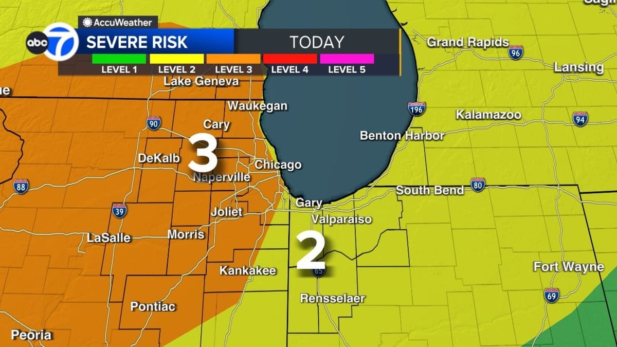
Radar imagery on Thursday showed multiple waves of strong to severe storms tracking from west to east across northern Illinois, impacting the Chicago metro area during the late afternoon and evening. Forecast discussions indicated an enhanced risk for severe weather, with a corridor of stronger storms organizing along and ahead of a cold front as it approached the city.
The most intense activity developed during the prime late day window between roughly 3 p.m. and 9 p.m. Central Time, a period often associated with the highest severe weather potential in the region. Storms quickly intensified as they moved out of Iowa into northern Illinois, tapping into unseasonably warm, humid air that pushed temperatures into the upper 60s and 70s across parts of the metro area.
As the main line approached Chicago, lightning frequency increased and wind gusts strengthened, with radar estimates and surface observations pointing to pockets of 50 to 60 mile per hour winds near the strongest cores. Hail reports ranged from small to near severe criteria in some suburbs, while torrential downpours led to rapid ponding on roads and low-lying areas.
By late evening, the most organized severe storms had moved east toward northwest Indiana and southwest Michigan, leaving behind lighter showers and residual thunder across the city. Forecast guidance showed additional, weaker disturbances possible into the overnight hours, but the overall severe threat was expected to gradually diminish after midnight.
Tornado warnings allowed to expire as rotation weakens
Earlier in the event, several storms embedded within the broader line briefly exhibited rotation signatures on radar, prompting tornado warnings for portions of northern and central Illinois. Discussion threads and alert summaries indicated that the warnings were issued for rapidly developing cells that showed tightening circulation as they moved northeast at highway speeds.
In at least one case, the storm environment evolved quickly enough that the circulation weakened within the lifespan of the warning, leading to the alert being allowed to expire as the threat subsided. Subsequent updates emphasized that, while the tornado potential had decreased, strong straight-line winds and hail remained a concern along the advancing line of thunderstorms.
Publicly available outlooks from national forecast centers had highlighted the risk for a few tornadoes, particularly in areas west and northwest of Chicago during the late afternoon and early evening. However, the dominant mode for much of the metro area appeared to be fast-moving line segments and clusters, which favored damaging winds and hail over long-lived, discrete tornado-producing supercells.
As the storms consolidated and moved east, warnings transitioned from tornado-focused alerts to broader severe thunderstorm warnings covering multiple counties. Radar scans late in the evening showed a more linear structure to the storms, consistent with a decreasing tornado threat even as pockets of strong winds and heavy rain persisted.
Live radar tracks shifting threats through the evening
Television and digital weather outlets in Chicago maintained live radar coverage through the afternoon and evening, tracking individual storm cells as they pulsed in intensity while crossing the region. Composite radar loops highlighted the evolution from earlier scattered storms to a more organized band sweeping toward the lakefront around the evening commute.
Live radar imagery showed classic signatures associated with severe thunderstorms, including bowing segments that signaled strong straight-line wind potential and embedded cores where hail was most likely. As the line moved over the city and into northwest Indiana, reflectivity data indicated repeated rounds of heavy rain over some of the same locations, raising concerns about localized flooding.
Forecast updates noted that additional development was possible behind the main line, particularly across parts of northern and central Illinois, as energy continued to rotate around the broader storm system. This raised the possibility of renewed showers and isolated thunderstorms into the overnight hours and early Friday, although with a generally lower likelihood of severe weather than the initial round.
Radar trends late Thursday suggested that the strongest instability was gradually shifting south and east of the core Chicago metro, which helped reduce the risk of further tornado warnings. Nonetheless, forecasters continued to monitor for any embedded circulations within the line, as even a weakening system can occasionally produce brief spin-up tornadoes along sharp wind shifts.
Wind, hail and flooding now the main concerns
With the primary tornado threat easing, attention turned to non-tornadic hazards across the Chicago area. Strong gradient and thunderstorm-induced winds remained a primary concern, with a wind advisory overlapping portions of the region where gusts could top 45 miles per hour, even outside of the heaviest storms.
In addition to the wind risk, forecasters highlighted the potential for large hail in stronger updrafts, particularly earlier in the evening when instability was greatest. Previous outlooks had warned of hail that could reach one inch in diameter or larger in the most intense storms, a threat that can damage vehicles, roofs and siding in affected neighborhoods.
Heavy rainfall associated with repeated storms also raised the prospect of localized flash flooding. Reports from earlier rounds of thunderstorms noted quick rises in creeks and standing water on urban roadways, conditions that can worsen when multiple storm cells track over the same corridor. Drainage-challenged locations, viaducts and underpasses were viewed as especially vulnerable to rapid water accumulation.
As cooler, more stable air filters in behind the departing system, forecast models indicated that the severe threat would continue to trend downward into Friday. However, lingering showers and a rumble of thunder remain possible, and saturated ground could contribute to additional minor flooding issues even after the strongest storms have passed.
Regional context and seasonal outlook
The severe weather episode comes during the heart of Illinois tornado and severe thunderstorm season, which historically peaks from April through June across the state. Preparedness materials from state and county emergency management agencies note that a significant share of Illinois tornadoes occur between mid-afternoon and late evening, aligning closely with the timing of Thursday’s storms.
In recent years, northern Illinois and the Chicago metro have experienced several notable severe weather events, including past outbreaks that produced strong tornadoes and damaging hail across Kankakee County and northwest Indiana. Climatological data and hazard planning documents for Cook County describe the region as vulnerable to a range of warm-season hazards, from fast-moving squall lines to isolated supercells capable of producing destructive tornadoes.
Seasonal outlooks heading into spring 2026 have emphasized the potential for active storm patterns across portions of the Midwest, with repeated rounds of thunderstorms tracking along sharp temperature gradients. The current system fits that pattern, featuring a surge of warm, moist air ahead of an advancing cold front and upper-level disturbance, a setup that commonly generates severe weather in the region.
As the calendar advances deeper into April and May, forecasters and emergency planners typically encourage residents across the Chicago area to revisit severe weather plans, monitor forecasts closely on days with elevated risk, and take warnings seriously when they are issued. Thursday’s storms, which brought a rapid escalation from routine showers to tornado warnings and intense lightning, provided a clear early season reminder of how quickly conditions can deteriorate during Midwest spring.