
Siem Reap can feel overwhelming on arrival. Temple names blur together, roads radiate out in every direction, and the fabled towers of Angkor Wat seem both close and impossibly far.
Understanding how Siem Reap’s town, temples, and surroundings fit together on the map makes the difference between a rushed checklist and a thoughtful journey through one of Asia’s most remarkable archaeological landscapes.
Orienting Yourself: The Big Picture of Siem Reap
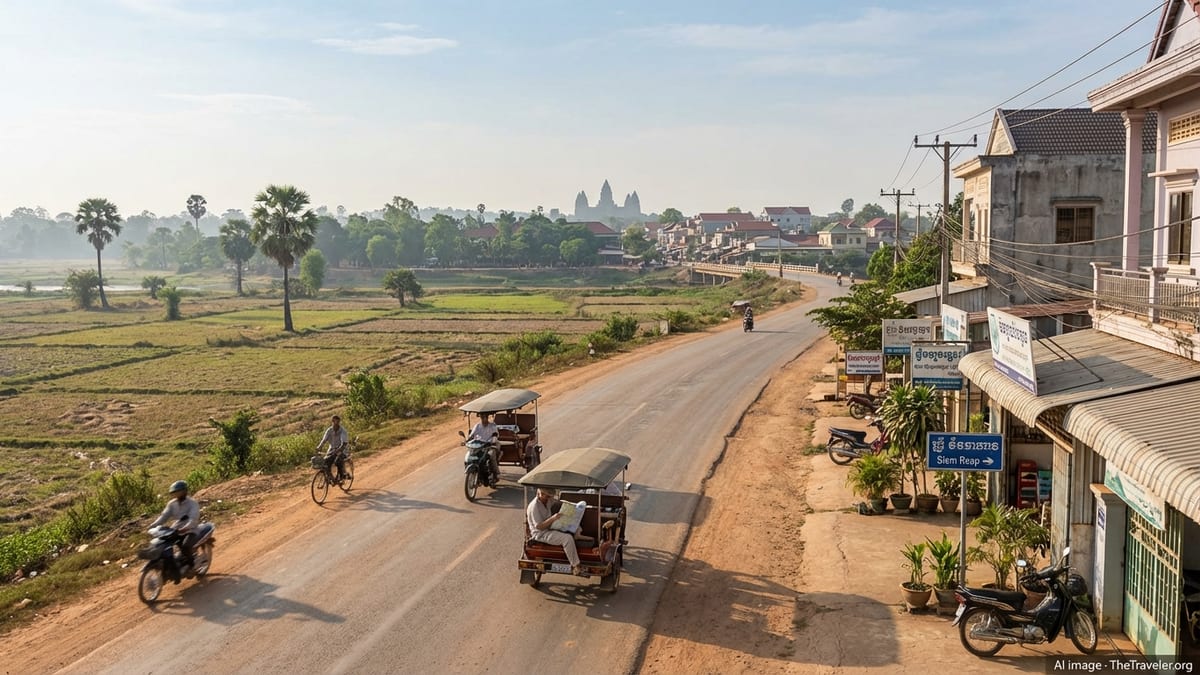
On the map, Siem Reap is a compact river town in northwestern Cambodia, sitting just south of the Angkor Archaeological Park and north of the vast Tonle Sap lake. The modern city is essentially the service hub for exploring Angkor, with guesthouses and hotels stretching along the river and highways, markets and restaurants clustered downtown, and a constant flow of tuk-tuks heading north toward the temples at sunrise. To the east and southeast lie the agricultural plains and the new international airport. To the west are smaller villages, rice paddies, and quieter rural roads.
The Angkor temple complex begins roughly 5 to 7 kilometers north of central Siem Reap. Angkor Wat lies at the southern edge of this archaeological zone, fronted by its broad moat and aligned almost directly north of the city. Beyond Angkor Wat, the fortified city of Angkor Thom spreads even further north, while additional temples extend in a loose fan to the east and west. Further away, satellite sites, floating villages, and countryside attractions round out the wider region.
When you look at a map, it helps to divide the area into three rings. The inner ring is Siem Reap town itself: where you sleep, eat, and plan. The middle ring is the Angkor Archaeological Park and immediately adjacent sites. The outer ring consists of more remote temples, Tonle Sap, and countryside excursions. Thinking in rings clarifies distances, daily logistics, and what is realistic to combine in one outing.
Downtown Siem Reap: River, Roads, and Neighborhoods
Central Siem Reap is built along the east and west banks of the Siem Reap River, a modest waterway flowing south from the Angkor area. On the map, the river acts as the easiest reference line. Bridges connect the two sides frequently, but many visitors gravitate to the western bank, where the Old Market, Pub Street area, and a dense cluster of hotels, cafes, and tour agencies are located. This compact core is walkable and serves as the social and commercial heart of town.
National Road 6, the main east–west highway across Cambodia, runs just north of the central core and is another key landmark for orienting yourself. Many larger hotels line this road as it approaches town from the airport side in the east and from the Battambang direction in the west. South of Road 6, streets grow narrower and busier, eventually blending into local neighborhoods and small markets. North of Road 6, the city starts to thin into quieter residential pockets and light commercial areas before rice fields take over.
The so-called “French Quarter” and surrounding blocks near the river offer a slightly more relaxed feel, with colonial-era shopfronts, boutique hotels, and leafy side streets. This area sits roughly between Pub Street to the south and Road 6 to the north. A short walk in any direction brings you to different moods: night-market bustle to the south, riverside promenades to the north, and backstreets filled with local eateries in between. Once you locate the river and Road 6 on your map, it becomes much easier to understand where you are at any moment.
Getting In and Out: Airports, Roads, and Arrival Points
A major recent change to the Siem Reap map is the opening of the new Siem Reap–Angkor International Airport in October 2023. Located about 50 kilometers east of town in Sotr Nikum district, the new airport replaced the former airport that once sat just a few kilometers from the center. For visitors, this means that the initial drive into Siem Reap now takes roughly one to one and a half hours by road, depending on traffic and time of day.
On most route maps, the airport appears as a large enclave amid rural fields east of the city, connected by a main access road that joins National Road 6 for the final stretch into town. Shuttle buses, private taxis, and pre-arranged transfers carry passengers from the terminal to central Siem Reap. Tuk-tuks are not permitted to wait at the airport itself, so you typically transfer to smaller local transport only after reaching town. Once there, most movement becomes much more compact and informal, with tuk-tuks, bicycles, and walking all practical options.
From Siem Reap, major roads fan out in several directions. National Road 6 continues east toward the Roluos Group of temples and Phnom Penh, while to the west it leads toward Battambang and the Thai border. Smaller paved roads and rural tracks head north toward Angkor, and south toward the Tonle Sap lake and its floating villages. Studying a basic road map before you arrive helps clarify how these routes interconnect and why certain day trips are paired together in tour itineraries.
Angkor Archaeological Park: Mapping the Classic Circuits
The Angkor Archaeological Park lies directly north of Siem Reap and is the core of most visitors’ experience. Angkor Wat sits near the southern edge of the park, with its iconic towers facing west across a wide moat and grand causeway. Roughly 1.7 kilometers north of Angkor Wat’s main entrance stands the South Gate of Angkor Thom, the walled city that once functioned as the Khmer capital. Angkor Thom’s walls form a square roughly 3 kilometers on each side, enclosing the Bayon and several key royal sites at its center.
Within this area, most guidebooks and tour operators refer to the “Small Circuit” and “Grand Circuit,” two looping routes that link the principal temples. The Small Circuit typically includes Angkor Wat, Angkor Thom with the Bayon, the Terrace of the Elephants, the Terrace of the Leper King, and the jungle temple of Ta Prohm to the east. This loop stays relatively close to town and is often recommended for a first full day of exploration, since it delivers many of the best-known sights with modest travel times between them.
The Grand Circuit extends further out, looping around additional temples such as Preah Khan, Neak Pean, Ta Som, and Pre Rup. It begins from the same general access point but then arcs farther east and north, reaching quieter corners of the archaeological zone. On a map, the Grand Circuit traces a wider oval around the Small Circuit. Many travelers dedicate at least one day to each loop, with sunrise and sunset stops layered on top.
Distances within the park are not vast, but the heat and the sheer amount of walking inside each complex make them feel larger than they appear. For example, it is only a few kilometers from Angkor Wat to Ta Prohm, yet you may spend hours at each site. When planning with a map, allow for time not only to travel between temples, but also to traverse their long causeways, galleries, and courtyards once you arrive.
Understanding Distances: How Far Everything Really Is
Visual scale can be deceiving when looking at a tourist map of Siem Reap and Angkor. It is roughly 5 to 7 kilometers from central Siem Reap to Angkor Wat, depending on where you start in town. By tuk-tuk, this drive usually takes about 15 to 20 minutes in the early morning, slightly longer later in the day. Cycling to Angkor Wat is common and generally takes around 30 to 45 minutes at a relaxed pace, following paved roads and well-marked turnoffs.
From Angkor Wat to the South Gate of Angkor Thom is approximately 1.7 kilometers, and then another short stretch to reach the Bayon at the heart of the walled city. Ta Prohm, the famous temple overgrown with tree roots, sits a few kilometers to the east of Angkor Thom’s walls. Travel times between these sites are usually under 20 minutes by tuk-tuk, but the walking involved once you arrive can be substantial, particularly at sprawling sites like Angkor Wat and Preah Khan.
More distant temple groups lie significantly farther out. The Roluos Group, home to early Angkorian sites such as Bakong and Preah Ko, is located roughly 12 to 13 kilometers east of central Siem Reap along National Road 6. Farther still, temples like Banteay Srei, Beng Mealea, and Koh Ker can lie 30 to 80 kilometers away from town. These journeys typically require a dedicated half day or longer by car or hired vehicle, and cannot realistically be folded into a heavy schedule inside the main park on the same day without feeling rushed.
Mapping attractions against travel times helps you avoid overcommitting. A practical rule is to treat the inner park as one zone and any site beyond about 15 kilometers from town as a separate excursion. Grouping nearby sites such as the Roluos temples with Tonle Sap, or Banteay Srei with countryside stops, makes the most of the time you spend on the road.
Practical Navigation: Tickets, Entrances, and Daily Flow
One feature that often confuses first-time visitors is the location of the main Angkor ticket office. The ticket center is not at Angkor Wat itself, but along a road northeast of Siem Reap, on the way to the archaeological park. On most maps, it appears between town and the temples, slightly off the most direct route to Angkor Wat. This means that on your first day of visiting, your tuk-tuk or car will typically detour past the ticket office to purchase or validate passes before reaching the temples.
Once inside the park, there are multiple access roads and entrances. Angkor Wat is usually approached from the west via the grand causeway, while Angkor Thom is entered through one of its monumental gates, most often the South Gate. Your driver will circulate along the loop roads surrounding the moats and walls, dropping you at designated parking areas near each site. It is common practice for drivers to wait in these lots while you explore on foot, then meet you at a pre-agreed spot and time.
Carrying a printed map or downloaded offline map on your phone is helpful not just for orientation but also for communication. Many drivers know the temples by their Khmer names or by landmarks rather than by English pronunciations, and pointing at a map can avoid confusion over similarly sounding sites. It is also wise to know the name and approximate location of your accommodation in town on the map, so that you can always find your way back even if you change tuk-tuks later in the day or evening.
Beyond the Temples: Tonle Sap, Villages, and Countryside
Looking south from Siem Reap on a map, you will see the massive outline of Tonle Sap, Southeast Asia’s largest freshwater lake. The lake’s northern shore lies roughly 10 to 15 kilometers from town, but the actual travel distance depends on which embarkation point you use. The road to Chong Kneas, one of the closest boat docks, leads south through suburbs and rice fields before reaching the lake’s edge. Other floating villages, such as Kampong Phluk and Kampong Khleang, lie further east along the edge of Tonle Sap and require longer drives.
These lakeside communities and stilted villages are often presented as “floating village tours.” On the map, they appear as small clusters of settlement along canals and lake inlets. Reaching them involves driving south or southeast from Siem Reap, then transferring to local boats. Because water levels and access channels change with the seasons, it is important to remember that fixed map lines on a screen may not fully reflect current navigation routes across the lake. Local guidance is essential.
North and east of town, away from the main cores of Angkor and Tonle Sap, lie quieter roads threading through paddies, sugar palms, and small market villages. Cycling routes and countryside tours often follow these lanes. Banteay Srei, a delicately carved temple in pink sandstone, sits to the northeast of the main Angkor group and is commonly paired with rural stops or a visit to the Landmine Museum nearby. Further still, remote temples like Beng Mealea and Koh Ker dot forested landscapes that once formed part of a much larger Angkorian network.
Safety, Seasonality, and Choosing When to Go Where
Siem Reap and Angkor welcome visitors year-round, but the experience on the ground is tied closely to climate and current events. On the map, dry season and wet season change what certain routes feel like. From roughly November to March, roads are generally dry, skies are clearer, and cycling or long tuk-tuk rides are more comfortable, though midday heat and crowds at popular temples can be intense. From around May to October, heavier rains transform the countryside into a vivid green patchwork, but some smaller roads become muddy and access to certain Tonle Sap villages can vary as water levels rise and fall.
In recent years, regional tensions and border incidents have also warranted attention. While Siem Reap itself remains open and busy with tourism, some governments have periodically urged travelers to exercise additional caution in areas near the Thai border and in specific provinces. Before setting out on overland routes beyond the immediate Siem Reap and Angkor area, it is sensible to check your own country’s latest travel advisories and consult local operators, who monitor security and road conditions closely.
Within the city and park, practical safety considerations are more routine: staying hydrated, protecting yourself from sun exposure, carrying a copy of your passport and visa, and using common sense when moving around at night. Tuk-tuks and local taxis follow well-traveled routes between town and temples, and the density of tourism infrastructure means that help is rarely far away. Knowing the basic layout of Siem Reap and Angkor on a map simply adds an extra layer of confidence to your movements.
The Takeaway
Understanding the geography of Siem Reap and Angkor profoundly shapes your visit. Instead of treating the temples as isolated photo stops, reading the map reveals them as pieces of a much larger cultural and physical landscape, strung along ancient processional ways, royal roads, and the edges of water reservoirs and rivers. Siem Reap town sits at the southern hinge of this world, linked now to a distant new airport in the east and to the Tonle Sap lake in the south, just as the Angkorian capitals once pivoted between upland cities and water-based communities.
By dividing the region into clear zones, recognizing realistic distances, and learning the main roads and arteries before you arrive, you can plan each day with purpose. One day might trace the classic Small Circuit, another the Grand Circuit, a third the early sites of Roluos or the intricately carved sanctuary of Banteay Srei, and yet another the floating villages of Tonle Sap. Each of these journeys follows lines you can trace in advance on even a simple map.
Most importantly, a solid grasp of the map gives you the freedom to move beyond rigid itineraries. With a sense of direction, you can adjust on the fly for weather, energy levels, or a sudden desire to revisit a favorite temple at a quieter hour. In Siem Reap, where history, landscape, and living communities interweave so closely, that freedom to wander thoughtfully is one of the greatest rewards of understanding the terrain.
FAQ
Q1. How far is Siem Reap town from Angkor Wat?
From central Siem Reap to the main entrance of Angkor Wat is roughly 5 to 7 kilometers, depending on where you start. By tuk-tuk, the journey usually takes about 15 to 20 minutes, while cycling at a relaxed pace can take around 30 to 45 minutes.
Q2. Where is the new Siem Reap–Angkor International Airport located on the map?
The new airport sits in Sotr Nikum district about 50 kilometers east of Siem Reap town. It is connected to the city by a main access road that links with National Road 6 for the final section into town, so your arrival transfer will typically follow that highway corridor.
Q3. Is it possible to walk between temples inside Angkor Archaeological Park?
You can walk short stretches between some neighboring temples, but the park is large and the climate can be demanding. Most visitors use tuk-tuks, bicycles, or cars to travel the main distances between sites, then explore each complex on foot once they arrive.
Q4. How are the Small Circuit and Grand Circuit different on the map?
The Small Circuit forms a tighter loop around Angkor Wat, Angkor Thom, and a few nearby temples such as Ta Prohm. The Grand Circuit traces a wider oval that reaches further north and east to include sites like Preah Khan, Neak Pean, and Ta Som, covering more ground and usually requiring a longer day.
Q5. Where is the Angkor ticket office located relative to the temples?
The main ticket office is situated northeast of Siem Reap, on the way to Angkor Archaeological Park but not right at Angkor Wat. Vehicles typically stop there first in the morning so visitors can buy or validate passes before continuing to the temple entrances.
Q6. How far is the Roluos Group from Siem Reap?
The Roluos Group, which includes Bakong and Preah Ko, lies about 12 to 13 kilometers east of central Siem Reap along National Road 6. Travel time is around 20 minutes by car or roughly 30 minutes by tuk-tuk, making it feasible as a half-day excursion.
Q7. What is the best way to get from Siem Reap to Tonle Sap lake?
To reach Tonle Sap, you travel south or southeast from Siem Reap by road to a chosen boat landing, such as those serving Chong Kneas, Kampong Phluk, or Kampong Khleang. From there, local boats take you onto the lake and through the floating or stilted villages.
Q8. Can I rely on online maps for navigating Siem Reap and Angkor?
Online maps are useful for orientation and planning, but mobile coverage and battery life can be unreliable in the field. It is wise to download offline maps in advance and carry a simple printed map as backup, especially if you plan to cycle or explore less visited routes.
Q9. How should I think about safety when planning routes around Siem Reap?
Within Siem Reap town and the main Angkor park, safety concerns are mostly practical: sun exposure, hydration, and normal urban awareness. For longer overland trips or visits near border regions, it is important to monitor current travel advisories and consult local operators who track both security and road conditions.
Q10. How many days do I need to cover what I see on the map?
If you want to see the main temples without rushing, plan at least three full days: one for the Small Circuit, one for the Grand Circuit, and one for either more distant temples such as Banteay Srei or the Roluos Group, or for Tonle Sap. Additional days allow for slower exploration, revisits at sunrise or sunset, and time to enjoy Siem Reap town itself.