
More news on this day
A sudden, fast-moving snow squall over northeastern Washington state on Thursday morning triggered urgent warnings to roughly 33,000 people, as forecasters cautioned that near-zero visibility and rapidly icing roads could turn routine commutes into life-threatening journeys within minutes.
Warning Blasts Across Northeastern Washington
The National Weather Service office in Spokane issued the rare snow squall warning shortly before 8 a.m. local time on Thursday, targeting communities in southeastern Stevens County and southern Pend Oreille County. The alert urged residents to delay all nonessential travel as the wall of snow and wind swept across the region.
Forecasters warned that the squall would bring intense bursts of heavy snow combined with strong, gusty winds, sharply reducing visibility to near zero at times. Within the polygon-shaped warning area, roughly 33,000 people were advised that any drivers caught on open roads could suddenly find themselves unable to see beyond the hood of their vehicles.
The warning, which was scheduled to remain in effect until around 9 a.m., covered small towns and rural communities including Colville, Chewelah, Newport, Springdale, Cusick and several nearby lakeside and campground areas. While the event was brief, meteorologists stressed that conditions could deteriorate so quickly that motorists might have little time to react.
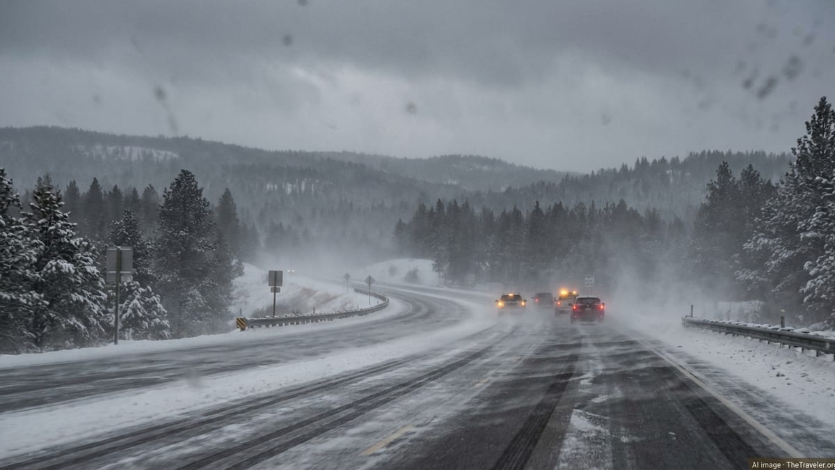
As the band of snow moved through, residents reported abrupt shifts from lightly falling flakes to whiteout conditions. Within a matter of minutes, familiar landscapes disappeared into a curtain of wind-driven snow, with local authorities urging people to pull off the road where possible and wait for visibility to improve.
Highways Turn Treacherous in Minutes
The snow squall cut across key travel routes in northeastern Washington, including stretches of U.S. Highway 20 and U.S. Highway 395. The warning specifically highlighted mile markers 355 to 436 on Highway 20 and mile markers 189 to 235 on Highway 395, corridors that carry a mix of commuter traffic, commercial trucks and winter travelers headed toward recreation areas.
State transportation officials and Washington State Patrol troopers moved quickly to relay the changing conditions, emphasizing that the danger came not only from fresh snow accumulation but from the sudden loss of visibility and slick, rapidly freezing pavement. Drivers were told to slow to well below the posted speed limits and be ready for abrupt stops.
Even a minor spinout or fender-bender in squall conditions can trigger a chain reaction as approaching motorists are unable to see stalled vehicles until it is too late. In past winter seasons across the United States, similar squalls have been linked to multi-vehicle pileups involving dozens of cars and trucks, some of them deadly.
On Thursday, road crews monitored the affected corridors for crashes and ice patches as the squall line advanced. With temperatures already below freezing, any slush created by vehicle traffic was expected to refreeze quickly, creating black ice on bridges, overpasses and shaded stretches of pavement long after the heaviest snow had passed.
What Makes a Snow Squall So Dangerous
Unlike a typical winter snow shower or a prolonged snowstorm, a snow squall is a compact, fast-moving burst of intense snowfall accompanied by strong winds and falling temperatures. The National Weather Service classifies it as a short-lived but high-impact event, capable of transforming road conditions from manageable to perilous in a matter of minutes.
Visibility in a snow squall can drop below one quarter of a mile, sometimes to effectively zero, as wind lifts fresh flakes and existing powder into the air. At the same time, subfreezing surface temperatures allow moisture on roads to flash-freeze into a thin, nearly invisible sheet of ice, catching drivers off guard.
The brevity of a snow squall can be deceptive. Many produce only an inch or less of total accumulation, yet they have a long history across North America of causing serious and sometimes fatal traffic accidents. Drivers often underestimate the risk, assuming that a quick burst of snow is less threatening than a named winter storm.
In recent years, meteorologists have worked to improve public understanding of squalls by issuing dedicated snow squall warnings, akin to severe thunderstorm or tornado warnings. These alerts are designed to be highly localized and time specific, urging those in the path to either delay travel or take immediate shelter off the roadway until the worst conditions pass.
Part of a Wider Pattern of Western Winter Extremes
The sudden squall in Washington arrived amid a broader pattern of powerful winter weather systems pummeling the western United States during February. In the days leading up to Thursday’s event, a series of storms had been forecast to deliver several feet of snow at higher elevations in the Cascades and inland Northwest, along with pockets of hazardous driving conditions at lower elevations.
Farther south, forecasters warned of a separate, exceptionally intense sequence of storms bearing down on California and Nevada, capable of dumping double-digit feet of snow on parts of the Sierra Nevada and generating wind gusts over 100 miles per hour. Those storms were expected to create prolonged whiteout conditions over mountain passes and ski corridors, disrupting both regional travel and tourism.
Closer to the Puget Sound lowlands, colder air and intermittent moisture have already produced slick roads and school closures following light to moderate snowfall this week. Transportation and emergency officials across Washington have been using the high-profile snow squall warning as an opportunity to underscore just how quickly winter conditions can escalate.
Meteorologists say that while snow squalls are not new to the Inland Northwest, improvements in radar, modeling and communication have allowed forecasters to pinpoint their development and path more effectively. As the atmosphere remains primed with cold air and passing disturbances, similar localized bursts of heavy snow remain possible through the current storm cycle.
Travelers Caught Between Routine and Risk
For residents of northeastern Washington, winter travel is a familiar reality, but Thursday’s squall illustrated the fine line between a routine drive and a dangerous one. Many commuters were already on the road when mobile phones across the region buzzed with the snow squall alert, forcing quick decisions about whether to continue, turn back or pull over.
Those who encountered the heart of the squall described a disorienting white curtain that erased the horizon and dulled sound, with only the faint glow of brake lights ahead to indicate other vehicles. Even drivers accustomed to snow found themselves reducing speed to a crawl, hazard lights flashing as they navigated barely visible lane markings.
Public safety officials repeatedly emphasized one key message: treating a snow squall like a typical snow shower can be a deadly mistake. Motorists were urged to avoid slamming on brakes, which can trigger skids on the newly formed ice, and instead to ease off the accelerator, increase following distance and, where possible, exit to a safe location away from traffic lanes.
For those planning longer journeys across the region, the squall served as a reminder of the importance of checking updated forecasts and real-time road reports before departure. Even when broader regional forecasts call for only light snow, narrow bands such as Thursday’s can temporarily turn a single stretch of highway into a high-risk zone.
How Authorities Respond to a Squall
Behind the scenes, a sudden squall sets in motion a rapid-response effort that involves meteorologists, emergency managers, transportation departments and law enforcement. At the Spokane forecast office, forecasters monitor radar and satellite imagery for the formation of intense, narrow bands of snow along advancing cold fronts.
Once a squall’s trajectory and timing appear clear, the office issues a polygon-based snow squall warning aimed at the specific counties, towns and highway segments in its path. Local emergency management agencies in Stevens and Pend Oreille counties then help amplify the message, relaying the alert across social media, local radio and emergency notification systems.
On the roads, Washington State Department of Transportation crews work to pre-treat priority corridors where possible and respond quickly with plows and sanders as conditions worsen. Troopers with the Washington State Patrol increase patrols along affected stretches of Highway 20 and Highway 395, watching for crashes, stranded drivers and sudden icing on bridges and overpasses.
Officials stress that their efforts are most effective when drivers heed the warnings. In many past snow squall events elsewhere in the country, some of the worst pileups have involved motorists who pressed on at highway speeds despite alerts, only to encounter a solid wall of white and slick pavement a few miles down the road.
Safety Guidance for Drivers and Winter Travelers
As winter storms continue to sweep across the western United States, safety experts and meteorologists are urging anyone who plans to travel by road to review basic winter driving precautions, especially in regions where snow squalls are possible. The first recommendation is simple: if a snow squall warning is issued for your area, delay travel until the threat has passed whenever possible.
If you are already driving when a squall hits, officials advise immediately reducing speed, turning on low-beam headlights and hazard lights, and avoiding sudden lane changes. Following distance should be increased significantly to account for the longer stopping distances on icy roads. If visibility drops to near zero, it is safer to exit the roadway entirely at a designated off-ramp or rest area than to stop in a travel lane or on the shoulder.
Drivers are also encouraged to keep an emergency kit in their vehicles throughout the winter season, including warm clothing, blankets, water, basic tools, a flashlight and a fully charged mobile phone. In rural parts of northeastern Washington, where cell coverage can be spotty and distances between towns are large, these supplies can be critical if a vehicle becomes stranded.
For visitors to the region, including winter sports travelers headed to mountain resorts, local officials recommend building flexibility into itineraries. That may mean planning extra travel time, being prepared to change routes, or even delaying departures to avoid being on exposed highways when squall-prone cold fronts are expected to move through.
Tourism and the Winter Weather Reality in Washington
Washington state’s winter landscape, particularly in its northeastern reaches, draws a steady stream of visitors seeking snow sports, scenic drives and quiet cabin getaways. Towns near the mountains often count on this seasonal influx, even as they grapple with the realities of severe weather that can both attract and endanger travelers.
Events like Thursday’s snow squall highlight the delicate balance between promoting winter recreation and ensuring public safety. Local tourism boards emphasize that, with proper planning and respect for weather conditions, visitors can still enjoy the region’s forests, lakes and trails while minimizing risk.
Many lodging operators encourage guests to arrive with vehicles equipped for winter, including good-quality snow tires or chains where required, and to sign up for local emergency alerts. Some provide printed guidance on nearby routes most susceptible to sudden weather changes, along with alternative plans in case conditions deteriorate.
For now, residents and travelers across northeastern Washington are watching the skies and the forecast closely. While Thursday’s squall passed quickly, the season is far from over, and the same atmospheric setup that produced the sudden wall of snow could repeat as new storm systems roll in from the Pacific and sweep inland over the next several days.