
More news on this day
A powerful late-February nor’easter is slamming the Northeastern United States, with Maine joining Pennsylvania, Massachusetts, Rhode Island, New Hampshire and other states in a sprawling “snowpocalypse” that is dumping up to three feet of snow, grounding flights, closing highways and disrupting travel across one of the nation’s busiest corridors.
Blizzard Conditions Sweep From Mid-Atlantic to Northern New England
The fast-deepening coastal storm, a classic winter nor’easter, is tracking up the Eastern Seaboard from Sunday into Monday, delivering heavy, wind-driven snow from the central Appalachians to Downeast Maine. Forecasters warn that snow totals could exceed 30 inches in localized bands, particularly from eastern Pennsylvania through interior New England, where intense snowfall rates are expected to persist for hours.
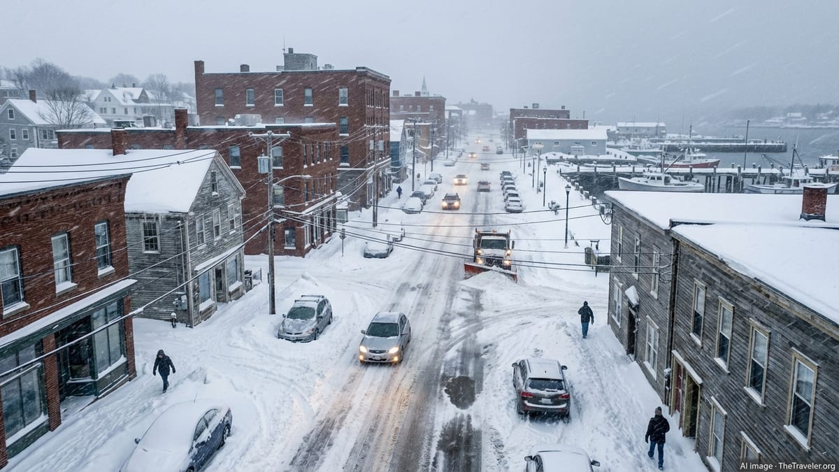
In Maine, where state offices will be closed Monday by order of Governor Janet Mills, the snow is forecast to build on already wintry ground, with the heaviest bands arriving overnight into Monday. While official projections focus on a general 7 to 14 inches across much of the state, meteorologists caution that narrow, slow-moving bands along the coast and higher terrain could see significantly higher totals as the system stalls and intensifies offshore.
Across southern New England and the Mid-Atlantic, including parts of Pennsylvania, Massachusetts, Rhode Island and New Hampshire, the nor’easter is combining deep Atlantic moisture with arctic air. That setup is producing widespread snow totals of one to two feet, with pockets pushing toward three feet where the heaviest bands pivot repeatedly over the same areas. Winds gusting above 40 to 60 miles per hour are turning otherwise heavy snow into near-blizzard conditions along exposed coastlines and open highways.
From the outer suburbs of Washington and Philadelphia to the coastal communities of Boston and Portland, whiteout conditions have periodically reduced visibility to near zero, turning routine weekend trips into dangerous journeys. Officials across the region are urging residents to stay off the roads unless absolutely necessary and to prepare for the possibility of being stranded if they venture out.
Air Travel Disrupted as Major Hubs Grind to a Halt
Air travel across the Northeast is bearing the brunt of the storm’s early punch, with thousands of flights delayed or canceled at key hubs stretching from Philadelphia and Newark to Boston and Portland. Airlines began issuing travel waivers well ahead of the storm, encouraging passengers to rebook for later in the week as forecast models converged on a high-impact scenario.
By Sunday afternoon, departure boards at major airports across Pennsylvania, New York and New England showed waves of red cancellations as blizzard conditions and poor visibility made operations unsafe. Ground crews have struggled to keep runways and taxiways clear amid persistent snow and strong crosswinds, while de-icing operations have slowed even those flights still attempting to depart.
Maine’s Portland International Jetport and Bangor International Airport have both warned of extensive disruptions, with many regional flights into smaller New England and Canadian airports canceled outright. Travelers already in the air have faced diversions to less-affected airports farther south and west, lengthening travel times and complicating airline logistics at the tail end of a busy midwinter school vacation period.
Rail services are also under pressure. Along the Northeast Corridor, operators have reduced schedules, preemptively canceled select trains and lowered maximum speeds in anticipation of snow-clogged tracks and drifting snow. The combined impact has left many travelers scrambling for alternative plans or resigned to extended layovers as the storm peaks.
Highways Turn Treacherous as States Urge Drivers to Stay Home
On the ground, major interstates and secondary roads from Pennsylvania to Maine have rapidly deteriorated as snow accumulates and winds pick up. Transportation departments across the region deployed plow and salt crews ahead of the storm, but heavy snowfall rates of one to two inches per hour have quickly outpaced efforts to keep surfaces clear.
In Pennsylvania, officials reported numerous accidents and jackknifed tractor-trailers on key stretches of Interstate 80 and 81 as visibility crashed and surfaces turned slick. Similar scenes have played out along Interstate 95 through New Jersey, New York, Connecticut and Rhode Island, where lane reductions, lowered speed limits and temporary closures have become commonplace through the day.
New Hampshire and Maine, accustomed to harsh winter conditions, have nonetheless urged drivers to avoid nonessential travel as the storm intensifies. Rural routes and mountain passes are expected to become particularly treacherous as drifting snow fills in plowed lanes and strong winds create sudden whiteouts, even in areas that receive somewhat lower accumulations.
State police and emergency responders are bracing for a surge in calls from stranded motorists as evening falls and temperatures tumble. Officials have emphasized that every vehicle stuck in the roadway not only endangers its occupants but also slows plow operations, prolonging hazardous conditions for everyone else.
Power Outages and Coastal Flooding Add to the Threat
Beyond snow and travel disruption, the storm poses a significant threat to power infrastructure along the Mid-Atlantic and New England coasts. With heavy, wet snow clinging to tree branches and power lines, and wind gusts periodically topping 50 to 70 miles per hour along exposed capes and headlands, utilities are warning of scattered to widespread outages through at least Monday night.
Crews in Pennsylvania, Massachusetts, Rhode Island and coastal Maine have been pre-positioned to respond quickly, but dangerous conditions may delay restoration efforts in the hardest-hit areas. Some communities still recovering from earlier winter storms this season now face the prospect of yet another round of downed lines and darkened neighborhoods.
Coastal flooding is emerging as a parallel concern. As the low-pressure system deepens off the coast, strong onshore winds are driving water toward shorelines from the Delaware and Chesapeake bays northward to Cape Cod and the Maine coast. With the storm overlapping high tide cycles, forecasters expect pockets of moderate flooding, overtopped seawalls and water-covered roadways in vulnerable low-lying areas.
In Rhode Island, Massachusetts and New Hampshire, local officials have advised residents in flood-prone waterfront neighborhoods to move vehicles to higher ground and avoid travel during high tide windows. Along sections of the Maine coast, where narrow harbors and inlets can amplify tidal surges, emergency managers are closely monitoring for rapid water rises that could affect homes, marinas and working waterfronts.
States Activate Emergency Measures as Storm Intensifies
With confidence growing in the high-impact nature of the storm, governors and local leaders across the Northeast have enacted emergency measures aimed at keeping people safe and preserving critical services. In Maine, Governor Janet Mills ordered all state offices closed statewide on Monday, citing forecasts for heavy snow, strong winds and dangerous travel conditions. Other states have followed suit with remote-work directives, delayed openings or full closures for many government offices.
Emergency operations centers in states including Pennsylvania, Massachusetts, Rhode Island and New Hampshire are operating at elevated readiness levels, coordinating with transportation agencies, utilities, local governments and hospitals. Many jurisdictions have placed tow and plow restrictions on certain roads, particularly for high-profile trucks, in advance of the worst conditions.
Snow emergency declarations are in effect in numerous municipalities, triggering parking bans on major arteries to keep lanes open for plows and emergency vehicles. In Boston, Providence and Portland, residents have been urged to move cars off designated snow routes to avoid towing and ensure plows can operate efficiently overnight.
School districts across the region preemptively canceled Monday classes or announced remote learning, recognizing that the combination of deep snow, bitter wind chills and reduced visibility would make bus routes too dangerous. For families just returning from winter break or ski trips, the storm has abruptly extended the vacation, albeit in far less relaxing fashion.
Travelers and Tourism Sector Face Major Midwinter Setback
The travel and tourism sector, already contending with a bruising stretch of back-to-back winter systems, is facing another costly disruption. Hotels near major airports and along interstate corridors from Philadelphia to Bangor have reported a spike in last-minute bookings as stranded travelers look for a place to ride out the storm.
In Maine, where winter tourism is a vital pillar of the economy, the nor’easter is a mixed blessing. Ski resorts and snowmobile destinations in the western mountains and northern interior stand to gain from deep new snow, but hazardous road conditions are likely to deter visitors in the crucial hours and days immediately surrounding the storm. Many operators are urging guests to delay arrival until plow crews can safely reopen key access routes.
Along the coasts of Massachusetts, Rhode Island and New Hampshire, coastal inns and short-term rentals that cater to off-season getaways are grappling with cancellations. Some properties have shifted to serving local residents seeking backup lodging in case of extended power outages or impassable roads, transforming restful retreats into emergency refuges.
Airlines and rail operators expect the ripple effects of the storm to be felt well beyond the Northeast. Equipment and crews stranded by the snowpocalypse will disrupt schedules across the national network, and carriers are cautioning travelers with connections through the region to monitor their itineraries closely and build in extra time for rebooking.
Communities Lean on Preparedness and Past Storm Lessons
For many residents across the Northeast, the unfolding storm revives memories of earlier blockbuster blizzards that crippled the region, from the Blizzard of 1978 to more recent bomb cyclones and multi-day whiteouts. In the wake of those events, communities have refined their approach to storm preparation, communication and recovery, lessons that are proving valuable once again.
Supermarkets and hardware stores from Pennsylvania through Maine saw brisk business in the days leading up to the nor’easter, as residents stocked up on food, batteries, snowmelt and generator fuel. Local officials have emphasized the importance of having enough supplies to remain safely at home for at least 48 to 72 hours, particularly for those living on secondary or rural roads likely to be among the last plowed.
Digital tools and social media are playing a central role in keeping people informed, with meteorological agencies, transportation departments and emergency managers issuing frequent updates on snowfall totals, changing road conditions and power restoration efforts. At the same time, authorities are warning residents to treat unverified posts with caution and to rely on official channels for critical safety information.
Community groups, from volunteer fire departments to neighborhood associations, are checking in on older residents and those with limited mobility, encouraging the use of phone trees and text chains to ensure that vulnerable neighbors are not left isolated as the storm intensifies. In many towns, storm preparation has become a collective ritual, reinforcing social ties even as the weather keeps people physically apart.
What Comes Next as the Storm Slowly Moves Offshore
Forecasters expect the nor’easter to continue strengthening into Monday before gradually tracking farther offshore and beginning to loosen its grip on the coast. However, the storm’s slow movement means that many areas, particularly across New England and coastal Maine, will remain under heavy snow and strong winds well into the workweek.
Even after the final flakes fall, hazardous conditions will linger. Deep drifts, narrowed roadways and blocked sidewalks will complicate commutes and emergency responses. As temperatures remain below freezing in the days ahead, refreezing of melted snow and slush will create fresh layers of ice each night, preserving treacherous surfaces long after skies clear.
For travelers, the advice from officials and industry leaders is clear: expect delays, stay flexible and prioritize safety over rigid schedules. Those planning road trips through the region are being urged to monitor state transportation alerts, carry winter emergency kits and be prepared to postpone departures if conditions do not improve as quickly as hoped.
In a winter already marked by a string of powerful systems from the southern Plains to the New England coast, this latest snowpocalypse underscores the enduring power of late-season storms to reshape plans, test infrastructure and remind travelers of the risks that can come with venturing out at the height of a Northeast blizzard.