
More news on this day
A fast-changing spring storm pattern over the western United States is steering pockets of heavy rain, gusty thunderstorms and even accumulating snow into a wide arc of cities from Palm Springs and Phoenix to Las Vegas, Denver and Flagstaff, creating unusual travel conditions across some of the country’s most popular desert and mountain gateways.
Get the latest news straight to your inbox!
Storm Track Shifts, Linking Desert Resorts and Mountain Hubs
Publicly available meteorological analyses for late March 2026 indicate that a series of upper-level disturbances is sweeping across the West, tapping Pacific moisture and colliding with lingering pockets of colder air over the Rockies and high plateaus. As the storm energy moves east, it is helping to trigger thunderstorms over desert metros such as Palm Springs, Phoenix and Las Vegas, while the same system produces snow over higher terrain near Denver and Flagstaff.
Forecast discussions and regional outlooks describe a broad corridor of unsettled weather, with bands of showers and storms pivoting from Southern California through the lower Colorado River Valley and into the Four Corners region. In many locations, bursts of rain are being accompanied by strong, shifting winds that can produce localized blowing dust in the deserts and brief whiteout conditions over nearby mountain passes.
The pattern follows a winter already marked by notable extremes in the United States, including major snowstorms, cold outbreaks and earlier episodes of heavy Western precipitation. Current projections suggest this latest round of active weather will be shorter-lived but still impactful, especially for travelers expecting reliably dry and mild spring conditions in the Southwest.
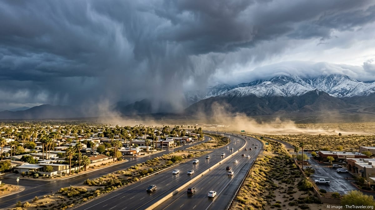
Palm Springs Sees Unsettled Skies on the Edge of the Storm
For Palm Springs and the broader Coachella Valley, outlooks show the city sitting near the southern and western flank of the storm corridor, where scattered showers, isolated thunderstorms and gusty winds are possible as individual disturbances move inland. While long-term climatology for March in Palm Springs favors dry, sunny days, recent weeks have already featured periods of rain and cooler temperatures between hotter spells, priming visitors for more changeable conditions than usual.
Rainfall amounts in the valley itself are expected to be modest compared with higher surrounding terrain, but brief downpours can still create slick roads and reduced visibility on Highways 111 and 74, as well as on Interstate 10. When thunderstorms develop, they may bring sudden wind shifts that can affect outdoor dining setups, pool decks and open-air events that are central to the region’s tourism economy.
Higher elevations overlooking Palm Springs, including the upper slopes reached by the Palm Springs Aerial Tramway, are more exposed to colder air and heavier precipitation. Forecast discussions point to the potential for wet snow at the highest ridges, a reminder that winter conditions can linger just above the desert floor even as valley temperatures quickly rebound between storm pulses.
Desert Southwest: Phoenix and Las Vegas Navigate Thunderstorms and Wind
Across the lower Colorado River Valley, travel hubs such as Phoenix and Las Vegas are also in the path of the unsettled pattern. Short-term outlooks point to waves of cloud cover, showers and thunderstorms spreading across both metros, punctuated by windy periods that could influence air travel operations and driving conditions on long, exposed highway stretches.
In Phoenix, guidance highlights the possibility of afternoon and evening storms forming along boundaries where cooler air aloft overlaps with daytime heating. These storms may produce brief heavy rain, lightning and small hail, along with strong outflow winds that can quickly lower visibility with blowing dust on roadways leading to and from popular desert parks and suburban resorts.
Las Vegas is anticipated to see a similar mix of passing showers and isolated thunderstorms, with the strongest activity more likely over surrounding mountains and plateaus. Visitors moving between the Las Vegas Strip, nearby national recreation areas and regional highways could encounter rapidly changing skies, from bright sun to dark, gusty cloud decks within a short drive.
Denver and Flagstaff Face Late-Season Snow and Difficult Travel
Farther northeast along the storm track, colder air entrenched over the central Rockies and the Colorado Plateau is supporting periods of accumulating snow in and around Denver and Flagstaff. Recent storm summaries for the region have already noted significant snowfall in Colorado earlier in March, and the latest updates point to additional rounds of late-season snow, especially at higher elevations.
In Denver, publicly available data shows that the city has experienced sizable snow events this season when similar systems tapped moisture and upslope flow along the Front Range. With the current pattern, forecasters are again emphasizing the potential for slushy to snow-covered roads, localized flight delays and visibility reductions during heavier bursts of precipitation, particularly during morning and evening commute windows.
Flagstaff, sitting at over 6,000 feet in northern Arizona, routinely transitions from rain to snow during strong March storms. The newest outlooks indicate that colder segments of this system could deliver several inches of wet snow to the city and more on surrounding peaks. Snow-packed stretches of Interstates 17 and 40, along with state routes that connect to Grand Canyon National Park and other high-country attractions, may see travel slowdowns or temporary restrictions as plows work to keep up.
What Travelers Should Expect in the Coming Days
Across the West, the evolving storm pattern means that travelers can expect large day-to-day swings, with sunshine and mild air quickly giving way to clouds, showers or snow depending on elevation and timing. Forecast products suggest that the most intense impacts from the current system will likely play out over a several-day window, but lingering disturbances may keep conditions unsettled in some areas longer.
For desert destinations including Palm Springs, Phoenix and Las Vegas, the primary concerns are likely to be gusty winds, brief heavy rainfall, lightning and the possibility of sudden temperature drops during frontal passages. Visitors planning outdoor activities or road trips are being encouraged by publicly shared advisories to monitor short-term forecasts closely, particularly during afternoons and evenings when thunderstorms are more likely to develop.
In higher-elevation corridors around Denver, Flagstaff and nearby mountain communities, accumulating snow, icy spots and low visibility remain important considerations. Travel-oriented guidance continues to recommend flexible itineraries, extra time for airport connections, and readiness for winter driving conditions even as the calendar moves deeper into spring. The result is a snapshot of the American West where iconic sun-soaked resort towns and snow-covered mountain gateways are once again linked by the same far-reaching storm track.