
More news on this day
A sprawling late-season winter storm sweeping across the central and eastern United States this weekend is colliding with peak spring break travel, triggering widespread flight cancellations, blizzard warnings and dangerous road conditions from the Rockies to the Great Lakes and into the Northeast.
Get the latest news straight to your inbox!
Storm System Slams Busy Spring Break Corridors
Publicly available forecasts and news coverage on March 15 indicate that a deep low-pressure system is tracking from the central Plains into the Upper Midwest, spinning off heavy snow, high winds and severe thunderstorms along a broad front. Blizzard conditions are being reported or forecast in parts of the Dakotas, Minnesota, Wisconsin and the upper Great Lakes region, while rain, thunderstorms and strong crosswinds extend south and east along key airline and interstate corridors.
The timing is particularly disruptive for families and college students heading to and from popular spring break destinations. Major hubs that connect sun destinations in Florida, Texas, Arizona and the Caribbean with the rest of the country are in the path of the unsettled weather, increasing the likelihood that delays and cancellations in one region ripple across the national network.
Travel industry data and airport projections show that this weekend and the days around it rank among the busiest of the season. Dallas–Fort Worth International, for example, expects millions of passengers between early and mid-March, with March 13 to 16 highlighted as peak days. Similar surges are being reported at Chicago, Denver and Atlanta, placing additional pressure on airlines and airport operations as the storm intensifies.
Meteorologists describe a classic March clash of lingering Arctic air with building spring warmth across the South. That pattern is supporting heavy wet snow and whiteout conditions on the cold side of the storm, while fueling bands of severe thunderstorms, damaging winds and possible tornadoes along its warmer flank, especially across parts of the Midwest and Ohio Valley.
Airlines Cancel Hundreds of Flights and Issue Weather Waivers
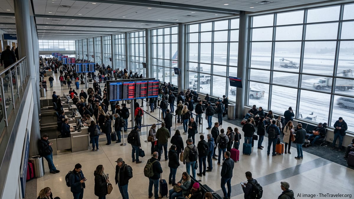
According to airline status dashboards and aviation tracking services on Sunday, carriers have already canceled or delayed hundreds of flights at hubs in Chicago, Minneapolis–St. Paul, Denver and Detroit as the combination of snow, low visibility and strong winds disrupts operations. Additional knock-on delays are being reported at downstream airports that depend on connections through those hubs.
Several major airlines have responded by publishing flexible travel policies for affected regions. Public advisories show systemwide or regional weather waivers covering Midwest winter weather, Chicago-area thunderstorms and approaching East Coast storms, allowing travelers with tickets between roughly March 10 and March 22 on select routes to rebook without change fees or fare differences within specified windows.
The goal of these waivers is to encourage passengers to shift trips away from the most dangerous or congested time periods, helping carriers pre-emptively thin schedules and reposition aircraft and crews. Travel analysts note that after the widespread disruptions linked to January’s Winter Storm Fern, airlines have become more aggressive about canceling flights early when high-impact weather appears likely.
Despite these efforts, images and social media posts from airports on Sunday show long lines at customer service counters, crowded gate areas and departure boards filled with delays. For travelers bound for beach destinations or returning from week-long breaks, even short disruptions can cascade into missed connections and lost vacation days, especially where flights operate only once daily.
Blizzard Warnings and Hazardous Roads Across the Upper Midwest
National Weather Service alerts issued this weekend include blizzard warnings, winter storm warnings and winter weather advisories from parts of the northern Rockies across the northern Plains into the Upper Midwest and Great Lakes. These bulletins highlight periods of intense snowfall combined with wind gusts strong enough to create near-zero visibility and rapidly drifting snow on open stretches of highway.
State transportation agencies in the Dakotas, Minnesota, Iowa and Wisconsin are reporting deteriorating conditions on interstates and rural roads, with sections of some highways temporarily closed or designated as travel not advised. Even in areas where total snow accumulations are moderate, strong winds are creating ground blizzards and sudden whiteout conditions that can catch drivers off guard.
For spring break travelers who opted to drive to ski resorts in the Rockies or to visit family in the northern tier, the storm is causing logistical headaches similar to those at the airports. Roadside cameras and traveler information systems show spinouts, jackknifed trucks and long stretches of slow-moving traffic, particularly near mountain passes and exposed prairie corridors.
Travel experts stress that, in many of these regions, March is historically one of the snowiest months, and powerful late-season storms are not unusual. However, the overlap this year with elevated leisure travel and lingering infrastructure challenges from earlier winter events is magnifying the disruption.
Severe Weather Threat Expands Toward the East
While heavy snow and blizzard conditions dominate headlines in the north and west, the warm sector of the storm is producing a different set of hazards. Forecast discussions from national storm centers outline a corridor of severe thunderstorms, damaging straight-line winds and potential tornadoes stretching from portions of the Plains into the Midwest and eventually the mid-Atlantic and Southeast through early next week.
Recent multi-day tornado outbreaks earlier in March have already impacted communities in Oklahoma, Illinois, Indiana and neighboring states. The same active jet stream and sharp temperature contrasts that supported those events are helping to energize the current system, raising concerns that new rounds of severe weather could impact ground transportation and airport operations far from the heaviest snow.
Major East Coast airports from Washington and Baltimore to New York and Boston are monitoring the progression of the storm as it tracks toward the Atlantic seaboard. Publicly posted travel alerts from at least one large carrier already extend to March 16 and 17 for potential thunderstorm impacts along the Eastern corridor, suggesting that spring break travelers could face renewed disruptions even after the worst of the blizzard conditions subside in the Midwest.
Rail and bus operators are also preparing for potential weather-related slowdowns, with expectations of downed tree limbs, scattered power outages and localized flooding in some urban areas. For travelers attempting multi-modal journeys, these overlapping risks complicate contingency planning.
Travelers Weigh Options as Spring Break Plans Unravel
With airline schedules in flux and highway conditions changing by the hour, spring break travelers across the country are being forced to make quick decisions about whether to press ahead, reroute or postpone trips altogether. Travel insurance providers and booking platforms report increased inquiries about change policies and same-day cancellations as the storm intensifies.
Consumer advocates note that in weather events of this scale, federal rules do not require airlines to provide hotel or meal vouchers when flights are canceled for safety reasons, though some carriers choose to offer limited assistance as a goodwill gesture. Travelers are encouraged by public advisories to check their airline’s mobile apps and text alerts frequently, verify the status of both outbound and return flights, and allow extra time for security and ground transportation.
For those still planning to fly in the coming days, aviation experts recommend avoiding tight connections through storm-affected hubs, traveling with carry-on baggage only where possible and being prepared for last-minute gate or aircraft changes. Drivers are being urged by transportation agencies to keep emergency kits in their vehicles, monitor road condition maps and be ready to delay or reroute if blizzard conditions intensify along their path.
As the current system continues its march eastward, forecasters indicate that additional waves of unsettled weather are possible later in March. With the spring break calendar stretching into early April for many school districts and universities, the 2026 travel season may continue to feel the impact of a volatile transition from winter to spring across much of the United States.