
More news on this day
A potent late-winter storm system sweeping across the eastern United States has triggered a cascade of flight cancellations and delays at Raleigh–Durham International Airport, stranding travelers and snarling airline schedules at one of the fastest-growing hubs in the region.
Get the latest news straight to your inbox!
Storm System Slams the East and Snarls RDU Operations
The severe weather hitting Raleigh–Durham is part of a larger storm complex that has marched east across the country over recent days, bringing heavy rain, powerful winds, and disruptive conditions to major population centers. Publicly available weather analyses describe a sprawling low pressure system generating a mix of thunderstorms, gusty crosswinds, and low cloud ceilings along key air corridors in the Mid Atlantic and Southeast, including North Carolina.
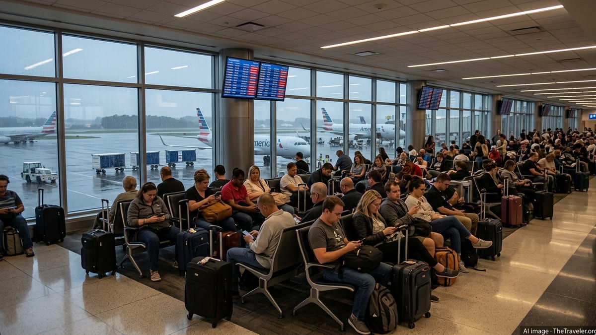
Flight tracking data and airline status boards on March 17 and March 18 indicate that this broader storm band has translated into elevated disruption at Raleigh–Durham International Airport, with waves of cancellations and rolling delays through the morning and afternoon peak periods. While totals have fluctuated by the hour as carriers attempt to reset their schedules, the airport has repeatedly appeared among the U.S. facilities experiencing the highest percentages of impacted flights in the region.
Operationally, weather impacts at RDU are being driven less by snow or ice and more by instability in the atmosphere. Strong upper level winds and bands of thunderstorms have reduced the window for safe departures and arrivals, limited usable runway configurations, and constrained the number of aircraft controllers can move per hour. The result for travelers has been a familiar pattern across concourses: crowded gate areas, long standby lists, and frequent gate-change announcements as airlines reshuffle aircraft and crews.
Ripple effects from the storm have been amplified by ongoing weather-related disruptions at other hubs, particularly along the East Coast and in major Midwestern cities. With carriers still working to reposition aircraft and crews from earlier storms this month, Raleigh–Durham has become both a victim of local conditions and of a systemwide scramble to restore normal operations.
How Many Flights Have Been Hit and Which Routes Are Worst Affected
Based on real-time flight tracking services and airline status pages reviewed on March 18, several hundred flights connected to Raleigh–Durham across a multi day window have been cancelled, delayed, or diverted as the storm system passed through. On the worst affected days, a significant share of the airport’s departures and arrivals either did not operate as scheduled or left hours behind plan, with disruption most acute during the early morning and late afternoon banks.
Routes linking RDU to major East Coast and Midwestern hubs appear to have absorbed the brunt of the cancellations. Flights to and from New York area airports, Washington, Boston, Chicago, and Atlanta showed elevated disruption as the same storm complex tightened capacity at multiple ends of those routes. When weather simultaneously reduces arrival rates at both a hub and spoke airport, schedules quickly unravel and recovery becomes more complex.
Long haul connections have also been affected. Transcontinental flights to West Coast destinations and onward international services, which depend on precise inbound connections from regional RDU feeders, have seen knock on delays when those shorter segments could not depart on time. In some cases, aircraft scheduled to operate longer routes remained out of position after being held or cancelled the previous day, leading airlines to proactively scrub or consolidate flights even before the most intense weather reached the Triangle.
Despite the severity of cancellations, many short haul flights within the Carolinas and neighboring states have continued to operate during quieter weather windows, albeit with slower turn times and occasional holding patterns. This uneven pattern has made it difficult for travelers to predict whether a particular service will run, contributing to the perception of chaos even as overall airport operations remain technically open.
Airlines Activate Weather Waivers and Recovery Schedules
Several major U.S. carriers serving Raleigh–Durham have activated weather related travel waivers this week covering a cluster of East Coast airports, including RDU. Publicly posted advisories by airlines describe flexible rebooking policies for customers scheduled to fly during the height of the storm, allowing them to change dates or routing within a limited window without additional change fees or fare differences in many cases.
These waivers are a common tool during large storm events and are designed to encourage travelers with flexible plans to move voluntarily to flights outside the most affected period. By spreading demand across more days, airlines can ease crowding at customer service desks and reduce the number of passengers stranded overnight when flights are eventually canceled for safety or operational reasons.
In parallel, carriers have been running recovery schedules to reposition aircraft and crews once conditions temporarily improve. Public operations dashboards and pilot reports referenced in online aviation communities indicate that some RDU bound aircraft have been routed through alternate hubs or turned on shorter legs to rebuild schedule integrity. This has sometimes resulted in last minute aircraft swaps and seat reassignments for travelers, particularly on busy business routes.
Industry data from past storms suggest that full recovery from a regional weather event can take several days, even after skies clear. With this storm interacting with earlier winter and early spring systems across the country, travelers flying through Raleigh–Durham in the coming days are being advised, through airline communications and travel alerts, to build in extra time and to monitor flight status frequently.
Inside the Traveler Experience at a Crowded RDU
Reports shared on public social media platforms and local discussion forums over the past several days depict a Raleigh–Durham terminal under strain but still functioning. Travelers have described crowded security checkpoints during early morning waves, gate areas filled with passengers from multiple canceled departures, and long queues at airline customer service counters as people seek rerouting options after missed connections.
As is often the case during severe weather disruptions, the experience has varied considerably depending on departure time, airline, and destination. Some passengers arriving to the airport in the middle of the day reported moving quickly through security and boarding flights that left with only minor delays. Others who were scheduled on late evening or early morning services affected by ground stops or reduced arrival rates encountered far longer waits and, in some cases, overnight stays in nearby hotels.
Ground transportation links to and from the airport have remained generally available, with regional transit information and ride share platforms showing heightened demand but no sustained shutdowns. However, heavy rain and gusty winds along Interstate 40 and surrounding highways have slowed travel times, prompting local travel advisories to recommend additional time for the trip to the airport.
Food concessions and retail outlets inside the terminals have seen surging demand as travelers spend unexpected extra hours at the airport. While no widespread closures have been reported, some concessions have operated with limited menus or earlier closing hours, a familiar pattern during irregular operations when staffing and deliveries are disrupted.
What Travelers Through RDU Should Expect Next
Short term forecasts indicate that the most intense phase of the storm is expected to move away from central North Carolina within the next day, reducing the immediate risk of further large waves of cancellations driven purely by local weather. However, with the same storm complex still tangling operations at other East Coast and Midwestern hubs, residual delays and scattered cancellations are likely to persist at Raleigh–Durham as the national system resets.
Airlines are continuing to encourage passengers with upcoming itineraries to use mobile apps and online tools to track their flights, select alternative routings where possible, and confirm seat assignments as aircraft types and schedules change. Historical patterns from previous multi day storms suggest that early morning departures often recover first, while late night and marginally profitable routes are more likely to remain consolidated or suspended until reliability improves.
For travelers connecting through RDU, travel experts and consumer advocates commonly recommend allowing longer layovers than usual, particularly for itineraries involving multiple weather sensitive hubs. Rebooking onto flights with more generous connection times can reduce the risk of missed onward segments, especially while airlines are still operating with limited spare aircraft and tight crew rotations.
As the Triangle region heads into the busy spring travel period, this latest episode of weather related disruption underscores the vulnerability of even sunbelt airports to major storm systems. With more passengers choosing Raleigh–Durham as a gateway for both domestic and international trips, any future storm of similar scale is likely to produce comparably visible ripples across the air travel network.