
More news on this day
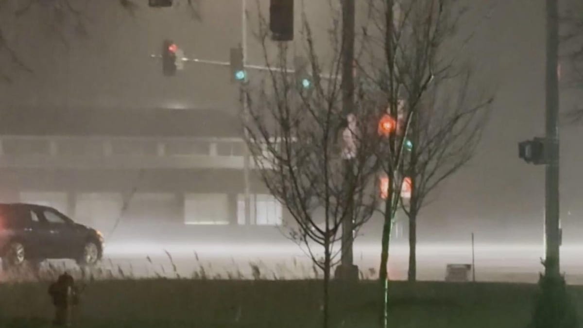
A volatile spring storm system swept across the Chicago area late Thursday and into Friday, unleashing heavy rain, powerful wind gusts and widespread travel disruptions across one of the Midwest’s busiest hubs.
Get the latest news straight to your inbox!
Two Rounds of Severe Weather Batter the Metro Area
Publicly available coverage indicates that the Chicago region endured at least two distinct rounds of thunderstorms on Thursday, April 2, as a vigorous storm system tracked across the Midwest. Early-day showers gave way to more intense evening storms, with radar estimates and media reports pointing to torrential downpours across much of northeastern Illinois.
According to regional news reports, peak wind gusts in parts of the metro area reached around 70 miles per hour as the strongest cells moved through. The storms were accompanied by frequent lightning, pockets of small hail and rapidly changing conditions that left little margin for drivers and commuters already on the move.
Storm coverage notes that a tornado watch was in effect for several hours Thursday as thunderstorms organized into stronger clusters capable of producing damaging winds and brief spin-ups. As of late Thursday night, however, there were no reports of a confirmed tornado directly impacting the core Chicago urban area, with the most significant hazards instead tied to wind, rain and localized flooding.
The unsettled pattern has continued into Friday, April 3, with additional showers and thunderstorms developing along and south of the city. Forecast discussions suggest that further downpours and gusty winds remain possible through the evening, maintaining an elevated risk of travel disruption.
Flooded Roads, Slick Highways and Challenging Commutes
Travelers across the Chicago region have faced difficult conditions on highways and local roads as the storms have rolled through. Reports from transportation corridors such as the Kennedy, Eisenhower and Stevenson expressways describe periods of very low visibility, ponding water and sudden bursts of wind that made lane-keeping difficult, particularly for high-profile vehicles.
Media outlets documented standing water at key access points near O’Hare International Airport on Thursday morning, including ramps leading to airport corridors. Similar problems were reported on stretches of I-90, I-55 and I-294, where drainage struggled to keep up with intense rainfall rates during the heaviest bursts.
Local coverage from regional outlets notes that some secondary roads and neighborhood streets saw minor flooding as leaves, branches and urban debris clogged storm drains. In a number of communities, drivers were forced to slow to a crawl or detour around water-covered intersections as bands of rain passed through during both the morning and evening rush periods.
Transportation summaries indicate that while widespread, long-duration closures were limited, the cumulative effect of repeated downpours and gusty winds has been a generally slower, more hazardous travel environment. Motorists moving in and out of the city core, particularly during peak hours, have been urged to allow extra time and remain alert for rapidly changing weather just ahead of each new wave of storms.
Flight Delays and Airport Operations Under Strain
With the Chicago area serving as a major aviation hub, the storms have had an outsized impact on air travel. Publicly available flight-tracking data and media reports from Thursday describe delays and congestion at both O’Hare and Midway airports as thunderstorms repeatedly passed over the region.
Earlier in the week, a separate round of thunderstorms prompted a ground stop at O’Hare, and the latest system has renewed weather-related strain on operations. While Thursday’s storms did not result in a prolonged full ground stop of the same magnitude, airlines contended with temporary holds, reroutes and reduced arrival and departure rates whenever lightning or severe weather approached airport airspace.
Passengers connecting through Chicago have encountered ripple effects, with some flights held on the tarmac until cells cleared and others diverted to alternate airports during the most active periods of lightning and wind. Published coverage notes that airlines have encouraged travelers to monitor their flight status closely and be prepared for rolling delays as storms continue to move across the wider Great Lakes corridor.
Given the potential for additional showers and storms into Friday evening, aviation observers expect intermittent disruptions to persist. Travelers heading into or out of the region are being advised to build extra flexibility into their plans, particularly for tight connections.
Power Outages, Event Disruptions and Localized Damage
Alongside travel headaches, the storms have produced scattered damage across parts of northern Illinois. Local media and utility updates cite pockets of downed branches and a limited number of toppled trees as intense wind gusts swept through neighborhoods and parkways late Thursday.
Thousands of customers across Illinois, Wisconsin and Michigan experienced power interruptions at the height of the storms, according to regional storm summaries. In and around Chicago, most outages were short-lived as crews moved quickly to remove branches from lines and reset equipment once lightning threats eased.
Recreational activities and large gatherings also felt the impact. Published coverage notes that the Chicago White Sox postponed their home opener on Thursday because of the volatile forecast and the risk of lightning and heavy rain over the ballpark. Smaller outdoor events and practices across the suburbs were scaled back or moved indoors as the storm threat became clearer through the day.
Structural damage across the core metro area has generally been limited, with reports largely focused on minor roof issues, damaged siding and shattered windows where debris became airborne. Nonetheless, the combination of strong winds and driving rain has underscored the vulnerability of older buildings and trees ahead of what is typically the most active severe-weather stretch of the year.
Ongoing Risks and What Travelers Should Expect Next
Forecast discussions from meteorologists indicate that the broader pattern driving this week’s storms remains in place into the weekend, keeping the door open for additional rounds of showers and thunderstorms. Cooler air aloft and lingering frontal boundaries over the Great Lakes continue to interact with Gulf moisture, fueling repeated waves of convection over the region.
For travelers, the immediate concern centers on short-notice changes. As cells blossom during the afternoon and evening, conditions can deteriorate quickly, with sudden bursts of heavy rain and wind even in areas that appear relatively calm just minutes beforehand. Those driving long distances across the Chicago area or connecting through its airports are being encouraged by public forecasts and travel advisories to keep a close eye on timing, particularly late in the day.
Rail and transit passengers may also encounter slower operations as agencies monitor track conditions and overhead lines in periods of strong wind and lightning. While large-scale cancellations have not been widely reported, schedules can become compressed when storms coincide with peak commuting windows, adding to crowding on platforms and in terminals.
Looking ahead, publicly available outlooks suggest that the most intense severe weather threat may gradually shift eastward, though showers and embedded thunderstorms could linger across northern Illinois into early Saturday. Until the current system fully exits, those planning trips in or through the Chicago area are likely to face a patchwork of improving but still changeable conditions, shaped by the timing and track of each successive band of storms.