
More news on this day
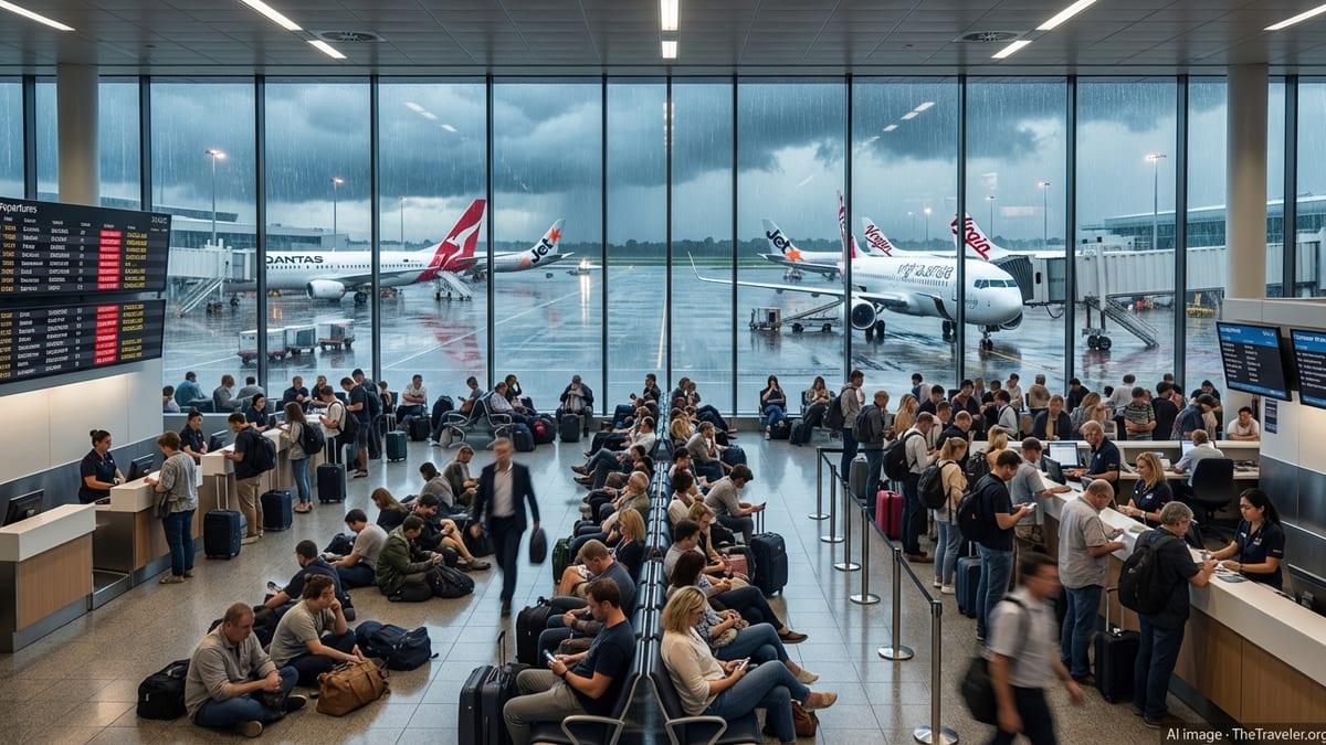
Spring thunderstorms across the Mid Atlantic have disrupted air travel at Washington’s three major airports, triggering ground stops and widespread delays at Reagan National, Baltimore/Washington International Thurgood Marshall and Washington Dulles International.
Get the latest news straight to your inbox!
Thunderstorms Trigger Ground Stops Across the Region
Strong, fast moving storm cells over the Washington and Baltimore region on April 1 led to temporary ground stops at Ronald Reagan Washington National Airport, Washington Dulles International Airport and Baltimore/Washington International Thurgood Marshall Airport. According to published coverage drawing on Federal Aviation Administration status updates, departures to the three airports were held while controllers slowed overall traffic into the storm affected airspace.
Publicly available FAA airport status pages for DCA, BWI and IAD indicated weather related arrival and departure delays as thunderstorms developed in the late afternoon and early evening. At one point, all three airports were under formal flow restrictions, with some flights held at their origin and others rerouted around the most intense storms.
Local television reports described the situation as a rolling disruption, with conditions shifting rapidly as the line of storms crossed the metro area. Operations were not fully halted for an extended period, but ground stops and delay programs were introduced and lifted in stages, producing uneven schedules and unpredictable departure times throughout the evening.
By late night, the most severe weather had cleared the immediate vicinity of the airports, but residual congestion in the national airspace system and continued pockets of rain in the wider Mid Atlantic region kept delays in place for some routes.
Passengers Face Cascading Delays and Missed Connections
For travelers passing through DCA, BWI and Dulles, the combination of thunderstorms and traffic management restrictions translated into long waits at gates and a spike in missed connections. Flight tracking boards at all three airports showed growing lists of late departures and arrivals, with some flights delayed by more than two hours.
Travel forums and social media posts from passengers described aircraft waiting on taxiways for takeoff clearance, as well as flights inbound to Washington that were placed in holding patterns or diverted to other airports until conditions improved. A number of travelers reported missed connections at major hubs when their Washington departures left too late to meet downline flights.
Airlines responded by offering same day rebooking where seats were available and, in some cases, waiving change fees tied specifically to Mid Atlantic thunderstorms. Publicly posted advisories from carriers referenced “weather in the Washington, DC region” and encouraged customers with flexible plans to move flights to earlier or later times within a limited window.
While the majority of disrupted flights eventually departed, the knock on effects extended into the following morning as aircraft and crews were out of position. Early day schedules on April 2 showed scattered delays and a few cancellations linked to aircraft that had not returned to their planned bases overnight.
Stormy Weather Adds Pressure to an Already Strained System
The latest disruptions come at a time when Washington area air travel has already been under pressure from a series of recent weather events and infrastructure issues. Earlier in March, a separate episode involving a chemical odor at the Potomac consolidated radar facility prompted region wide ground stops that also affected DCA, BWI and Dulles, leading to multi hour delays across the network.
Those earlier operational interruptions, combined with winter storms that swept across the Northeast and Mid Atlantic in late winter, have left airlines and travelers with little margin when new weather related problems arise. Schedule recovery can take longer when aircraft and crews are still cycling back from past disruptions, and publicly available performance data suggest that delay statistics for the Washington region have trended higher during the past several seasons.
Analysts who follow airline operations note that the Washington metro area is particularly sensitive to convective weather because of its location along major north south and east west corridors. When thunderstorms build over the region, traffic management initiatives can affect not only local departures and arrivals but also flights that would otherwise transit the underlying airspace, compounding gridlock.
In this instance, published flight tracking information indicated that some airlines chose to proactively slow their schedules into the area as the storm line approached, in an effort to reduce diversions and lengthy airborne holding. While such moves can add ground delay at origin airports, they can also prevent more disruptive midflight changes later in the evening.
Advice for Travelers Using DCA, BWI and Dulles
With spring thunderstorm season now underway, travel industry observers suggest that passengers using the Washington region’s three major airports prepare for intermittent weather related setbacks in the coming weeks. Publicly available guidance from airlines and the FAA emphasizes several practical steps that can help reduce the impact of sudden ground stops.
First, travelers are encouraged to monitor flight status closely through airline apps or airport displays, particularly in the 24 hours leading up to departure when weather forecasts become more precise. Same day schedule adjustments are often easier to secure before a storm fully develops, when more alternative seats remain open.
Second, passengers connecting through busy hubs may wish to build in longer layovers during periods of unsettled weather across the Mid Atlantic. Industry data and past disruptions show that relatively modest delays leaving DCA, BWI or Dulles can quickly erode tight connection windows, especially on evening departures when the schedule has less slack.
Finally, travelers are advised to factor in potential delays when planning time sensitive activities at their destination. Reports from recent episodes in the Washington area indicate that while many flights operate with only minor disruption, storms strong enough to trigger ground stops can still create multi hour delays for a meaningful share of departures.
Outlook for the Coming Days
Forecasts for the Washington and Baltimore region in the short term suggest a return to more stable conditions after the latest round of storms, with only scattered showers expected for portions of the upcoming weekend. However, meteorologists note that the broader pattern remains conducive to additional thunderstorm development as warmer, more humid air moves into the Mid Atlantic.
Publicly available long range outlooks point to an active spring for convective weather across the eastern United States, which could bring further periods of travel disruption to major hubs on the Interstate 95 corridor, including the Washington area. Airlines typically adjust staffing and fleet utilization in anticipation of these seasonal risks, but even well prepared operations can experience strain during peak storm events.
For now, operations at Reagan National, BWI Marshall and Dulles have largely returned to normal, aside from residual delays on a handful of routes where aircraft and crews remain out of sequence. As the busy spring and summer travel seasons approach, travelers using Washington area airports may continue to see intermittent weather related slowdowns whenever strong storms pass through the region.