
More news on this day
A fast-moving Sunday snowstorm blanketed the city in heavy, wet snow, disrupting air travel and leaving a glaze of ice on major roads just as residents prepared for the workweek ahead.
Get the latest news straight to your inbox!
Heavy Snowfall Transforms Sunday Morning Landscape
The storm arrived before dawn on Sunday, with radar imagery and local observations showing a band of intense snowfall sweeping across the metropolitan area and nearby suburbs. By midmorning, parks, rooftops and arterial corridors were covered in several inches of accumulation, with some neighborhoods reporting higher totals where snow bands stalled overhead.
Publicly available weather data indicates that temperatures hovered near the freezing mark for much of the event, allowing snow to stick quickly to untreated surfaces. That combination of marginal temperatures and steady precipitation produced a dense, moisture-laden snow that weighed on trees and power lines while also compacting into a slick layer on pavement.
Forecasters had flagged the system over the weekend as a disruptive event for transportation, noting the potential for rapid accumulation during the core Sunday morning travel window. As the snow intensified, visibility dropped sharply along major highways and approach routes to the city’s primary airport, complicating both ground and air operations.
By late morning, plows and salt trucks were making repeated passes on key corridors, but new snow continued to cover traffic lanes between treatments. Side streets and residential hills remained particularly difficult to navigate, with many drivers choosing to delay trips until later in the day.
Flight Schedules Strained by Snow and Ice
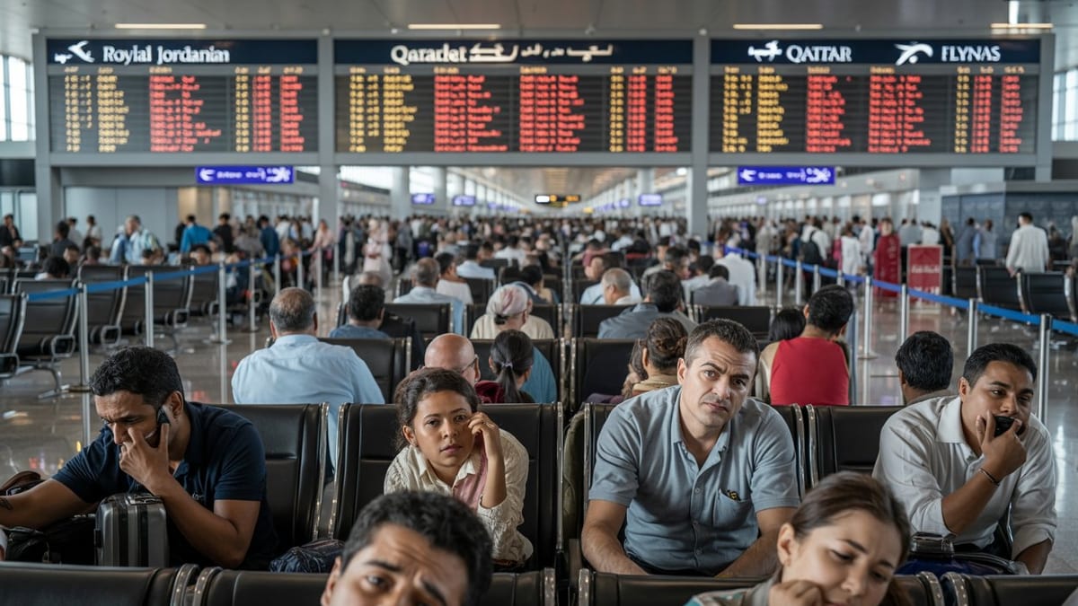
The storm’s greatest impact was felt at the city’s main airport, a critical hub for regional and cross-country travel. According to flight-tracking data, hundreds of departures and arrivals across the broader region were either delayed or canceled as airlines adjusted schedules to the changing runway and taxiway conditions.
As snow rates increased during the early morning push, crews conducted repeated cycles of plowing and deicing to keep key runways open. Ground operations were periodically slowed while equipment cleared accumulation and applied anti-icing treatments, stretching turnaround times for aircraft and causing a cascading effect through the day’s schedule.
Published coverage of the storm’s travel fallout describes extended queues at check-in counters, with many travelers attempting to rebook weekend returns or make tight connections onward. Some carriers issued flexible travel waivers in advance of the system, encouraging passengers to shift itineraries away from the Sunday morning peak.
By afternoon, as the heaviest snow moved offshore and visibility improved, operations gradually stabilized. However, lingering deicing needs and aircraft out of position from earlier disruptions meant that delays persisted well beyond the end of the snowfall, affecting flights into the evening and spilling into Monday’s schedule for some routes.
Icy Roads Turn Routine Drives Into Hazardous Journeys
On the ground, the storm converted familiar commutes and weekend errands into challenging drives. With air and pavement temperatures hovering near freezing, the earliest flakes melted on contact before refreezing into a thin glaze. As more snow accumulated on top, that ice layer became difficult to detect, creating what transportation agencies describe as classic black ice conditions.
Traffic cameras and publicly available transportation updates showed reduced speeds on major interstates and bridges, with scattered spinouts and minor collisions reported around ramps and elevated sections. Bridges, overpasses and shaded stretches were particularly prone to icing, even in areas where treatment trucks had made recent passes.
City and state transportation departments urged residents through social media and automated alerts to avoid unnecessary trips during the most intense snowfall. For those who had to be on the road, officials recommended allowing extra stopping distance, reducing speeds and taking additional time to clear snow and ice from vehicle windows and lights.
Pedestrians also contended with slippery conditions. Sidewalks and crosswalks near busy intersections became slick where foot traffic compacted the fresh snow. Transit riders navigating bus stops and station entrances faced icy steps and platforms, adding another layer of complexity to already slowed bus and rail networks.
Transit Networks and Local Services Adjust
The wider transportation network responded with a mix of service reductions and schedule adjustments. According to service alerts shared by local transit agencies, several bus routes were temporarily detoured away from steep hills and untreated side streets, while some express services operated on modified Sunday schedules.
Rail corridors fared somewhat better, but delays developed as crews cleared blowing and drifting snow from switches and station platforms. Commuter rail providers warned that travel times could be longer than usual, and some early-morning departures were consolidated to ensure adequate staffing and equipment.
Municipal public works departments activated winter response plans, deploying additional plows to cover residential neighborhoods once primary routes were stabilized. In some districts, on-street parking restrictions went into effect to create room for plows to push snow back from curbs and intersections, improving sightlines and making room for pedestrians at crosswalks.
Utilities monitored the situation closely as heavy, wet snow accumulated on tree limbs. While early reports indicated only localized outages, companies advised customers to prepare for potential interruptions if the weight of snow and ice increased or winds picked up behind the departing storm system.
Travelers and Residents Look Ahead to the Workweek
With the storm’s core now past, attention has shifted to cleanup efforts and the potential for lingering ice into Monday morning. Forecasts indicate that temperatures could dip below freezing again overnight, a pattern that often leads to refreezing of meltwater on sidewalks and secondary roads, especially in shaded areas and at intersections.
Airport operators and airlines have been working to realign schedules and crews for the coming days, aiming to restore normal operations ahead of the busy midweek travel period. Travelers are being advised, through airline alerts and public bulletins, to check their flight status frequently and allow additional time to move through security and deicing queues.
For local commuters, the focus will be on how quickly plows and salt crews can transition from main arteries to neighborhood streets. Morning bus routes and school transportation services will depend on improved traction on side roads and at bus stops, where packed snow can take longer to melt.
As the city digs out from another impactful winter event, transportation planners and weather agencies are expected to review the storm’s timeline and response, using the data to refine forecasts and operational strategies for the remainder of the cold season. For many residents and visitors, however, the defining memory of this system will be the quiet of a snow-covered Sunday morning contrasted with the complicated journeys that followed.